Plans, policies and reports
Great Barrier Island issues and options
Back to contents
Background
What is a district plan? | Why reveiw the
district plan | The HGI District Plan | The
HGI District Plan and Great Barrier Island | Land Units
1-10
What is a district plan?
The Resource Management Act 1991 (RMA) requires the council to have a
district plan for Auckland City. A district plan is a legal document, which sets
out the council's policies and strategies for managing the natural and physical
resources of the city.
The Auckland City District Plan is comprised of three sections:
- the Central Area section
- the Isthmus section and
- the Hauraki gulf Islands sections (HGI District Plan)
Why reveiw the district plan
Once a district plan is operative, the RMA requires it to be reviewed every
ten years.
As the current HGI District Plan became operative in July 1996, the council
is aiming to publicly notify the proposed (reviewed) plan in August 2006.
Another key driver for reviewing the HGI plan is to ensure it meets the
foreseeable needs of the environment and the communities for the ensuing ten
years.

The HGI District Plan
The current HGI District Plan is a single document and brings together all
the resource management issues facing the islands of the Hauraki Gulf: Waiheke,
Great Barrier, Rakino, Pakatoa, Ponui, Motuihe, Motutapu, Rotoroa, Brown's and Rangitoto
and a larger number if other smaller islands (the current plan applies to more
than 65 islands overall).
The resource management method adopted for the current HGI District Plan has
three primary elements:
Strategic Management Areas (SMA's)
There are 20 separate SMA's in the HGI plan. these are generally based on
natural drainage catchments. Common objectives and policies have been developed
for each SMA.
Land units - within each SMA
All land is given a land unit classification. the land
unit classification relates to the natural characteristics of the particular
land or the activities to be undertaken on that land. Each land unit has a set
of objectives, policies and rules which determine the nature and extent of
development that can occur in each land unit.
Policy areas
Policy areas are an additional layer of district plan provisions which contain
objectives. policies and rules which have been put in place where a more
developed and targeted planning approach is required eg wharf areas, commercial
areas and beach areas subject to relatively heavy development pressure.
The HGI District Plan and Great Barrier Island
The resource management method explained above is applied to Great Barrier
Island as shown in the diagram below
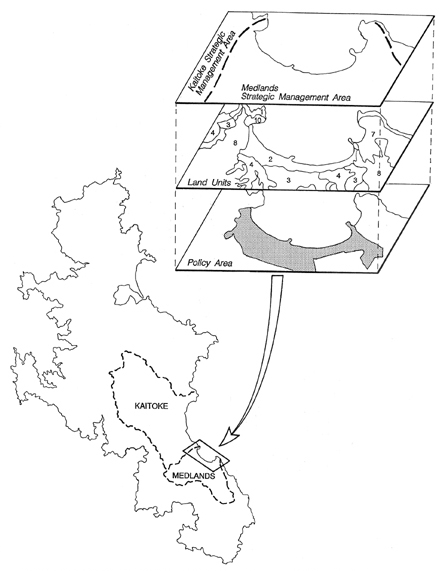
The current HGI District Plan contains 26 land units,
however only land units 1-10 are applied to Great barrier Island, the other
outer islands and eastern Waiheke.
Land units 1-10
| Land Unit 1 |
- Coastal Cliffs |
| Land Unit 2 |
- Dune Systems and Sand Flats |
| Land Unit 3 |
- Alluvial Flats |
| Land Unit 4 |
- Wetland Systems |
| Land Unit 5 |
- Foothills and Lower Slopes |
| Land Unit 6 |
- Steep Pastured Slopes |
| Land Unit 7 |
- Steep Infertile Coastal Slopes |
| Land Unit 8 |
- Regenerating Slopes |
| Land Unit 9 |
- Low Fertility Hills |
| Land Unit 10 |
- Forest and Bush Areas |