Plans, policies and reports
District Plan Hauraki Gulf Islands Section - Proposed 2006
(Notified version 2006)
Street index |
Planning maps |
Text |
Appendices |
Annexures |
Section 32 material |
Plan modifications |
Help |
Notified - Home |
Decision - Home
Appendix 1c - Schedule of conservation areas - inner islands
1.0 Introduction
2.0 Disclaimer for all diagrams in appendix 1c
3.0 Diagram of Rocky Bay conservation area
1.0 Introduction
This appendix contains key information about scheduled
conservation areas. The only such area currently scheduled in the Plan
is the Rocky Bay conservation area. This appendix contains a diagram
identifying the boundaries of the conservation area and its key components.
The character statement for the Rocky Bay conservation
area is contained in appendix 3 - Character statements for conservation
areas.
The criteria for scheduling conservation areas is contained
in appendix 4 - Criteria for scheduling heritage items.
2.0 Disclaimer
for all diagrams in appendix 1c
The diagrams show a green polygon (or several polygons)
around the scheduled item. The polygon (or polygons) constitutes the
definitive identity and location of the scheduled item.
Some diagrams may include parts of an item extending
below mean high water springs (MHWS). Areas below MHWS fall within the
jurisdiction of the Auckland Regional Council, and are therefore outside
the jurisdiction of this Plan. Any areas below MHWS are indicative and
shown for information purposes only.
3.0 Diagram of
Rocky Bay conservation area
hgiApp01c-15-10
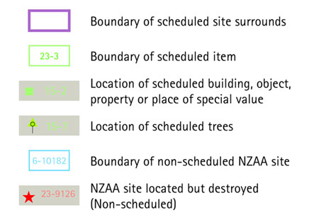
Diagram legend