District Plan Hauraki Gulf Islands Section - Proposed 2006
(Notified version 2006)
Street index |
Planning maps |
Text |
Appendices |
Annexures |
Section 32 material |
Plan modifications |
Help |
Notified - Home |
Decision - Home
Hearing reports index
| Report on submissions to the Auckland City
District Plan: Hauraki Gulf Islands Section - Proposed 2006 |
| Topic: |
Land units and settlement areas - general |
| |
|
| Report to: |
The Hearing Panel |
| Author: |
Katherine Dorofaeff, senior planner |
| Date: |
9 April 2008 |
| Group file: |
314/274013
|
1.0 Introduction
This report considers submissions and further submissions ('submissions') of
a general nature that were received by the council in relation to the provisions
for land units and settlement areas as contained in the Auckland City District
Plan: Hauraki Gulf Islands Section - Proposed 2006 ('the Plan'). The Plan was
publicly notified on 18 September 2006. The closing date for lodging submissions
was 11 December 2006. The submissions and summary of decisions requested were
publicly notified for further submission on 29 April 2007. The closing date for
lodging further submissions was 28 May 2007.
This report has been prepared under section 42A of the Resource Management
Act 1991 ('the RMA'), to assist the hearings panel to consider the general
submissions on the provisions applying to land units and settlement areas. The
submissions considered are those which relate to generally to parts 10a, 10b and
10c of the Plan but which cannot be allocated to any specific land unit, or
settlement area, or clause of the Plan. This report discusses the submissions
(grouped by subject matter or individually) and includes recommendations from
the planner who prepared this report. The recommendations identify whether each
submission should be accepted or rejected (in full or in part) and what
amendments (if any) should be made to the Plan to address matters raised in
submissions. Further submissions are not specifically addressed but are dealt
with in conjunction with the submissions to which they relate.
The recommendations contained in this report are not decisions of the
council. The council will issue its decisions following consideration of the
submissions, further submissions, any supporting evidence presented at the
hearing, and this report. The council's decisions will be released after all the
hearings to the Plan have been completed.
2.0 Statutory framework
This section of the report briefly sets out the statutory framework within
which the council must consider the submissions. In preparing this report the
submissions and, in particular, the decisions requested in the submissions, have
been considered in light of the relevant statutory matters. These were
summarised by the Environment Court in Eldamos Investments Limited v Gisborne
District Council W
047/05 where the court set out the following measures for evaluating
objectives, policies, rules and other methods in district plans:
- The objectives of the Plan are to be evaluated by the extent to which
they:
- Are the most appropriate way to achieve the purpose of the RMA
(s32(3)(a)); and
- Assist the council to carry out its functions in order to achieve the
purpose of the RMA (s72); and
- Are in accordance with the provisions of part 2 of the RMA (s74(1).
- The policies, rules, or other methods in the Plan are to be evaluated by
the extent to which they:
- Are the most appropriate way to achieve the objectives of the Plan
(s32(3)(b)); and
- Assist the council to carry out its functions in order to achieve the
purpose of the RMA (s72); and
- Are in accordance with the provisions of part 2 of the RMA (s74(1)); and
- (If a rule) achieve the objectives and policies of the Plan (s76(1)(b)).
The purpose of the RMA is "to promote the sustainable management of natural
and physical resources", and "sustainable management" is defined in section 5(2)
as meaning:
"... managing the use, development, and protection of natural and physical
resources in a way, or at a rate, which enables people and communities to
provide for their social, economic, and cultural wellbeing and for their health
and safety while—
(a) Sustaining the potential of natural and physical resources (excluding
minerals) to meet the reasonably foreseeable needs of future generations; and
(b) Safeguarding the life-supporting capacity of air, water, soil, and
ecosystems; and
(c) Avoiding, remedying, or mitigating any adverse effects of activities on
the environment."
Along with section 5, part 2 of the RMA includes sections 6 (matters of
national importance), 7 (other matters) and 8 (Treaty of Waitangi), which set
out a range of matters that the council needs to recognise and provide for in
achieving the purpose of the RMA. Those matters are also relevant when
considering submissions.
The Plan must assist the council to carry out its functions under section 31
of the RMA. These functions are:
"(a) The establishment, implementation, and review of objectives, policies,
and methods to achieve integrated management of the effects of the use,
development, or protection of land and associated natural and physical resources
of the district:
(b) the control of any actual or potential effects of the use, development,
or protection of land, including for the purpose of—
(i) the avoidance or mitigation of natural hazards; and
(ii) the prevention or mitigation of any adverse effects of the storage, use,
disposal, or transportation of hazardous substances; and
(iia) the prevention or mitigation of any adverse effects of the development,
subdivision, or use of contaminated land:
(iii) the maintenance of indigenous biological diversity:
(c) ...
(d) The control of the emission of noise and the mitigation of the effects of
noise:
(e) The control of any actual or potential effects of activities in relation
to the surface of water in rivers and lakes."
In addition to the matters listed above from the Eldamos decision:
- The Plan must "give effect to" any national policy statement and any New
Zealand coastal policy statement (s75(3)(a) and (b)).
- The Plan must "give effect to" the regional policy statement (made
operative after 10 August 2005) (s75(3)(c)).
- The Plan must be "not inconsistent with" any regional plan (s75(4)).
- The council must ensure that that the Plan does not conflict with sections
7 and 8 of the Hauraki Gulf Marine Park Act 2000 ("the HGMPA"). Section 10 of
the HGMPA requires that sections 7 and 8 of that Act be treated as a New
Zealand coastal policy statement under the RMA.
3.0 Background
This section of the report sets out background information about the topic
under consideration. It briefly describes those parts of the Plan that deal with
land units and settlement areas and associated objectives, policies and rules.
This report deals with general submissions about land units and settlement
areas. The objectives, policies and rules for land units and settlement areas
are contained in the following parts of the Plan:
- part 10a - Land units: objectives, policies and activity tables
- part 10b - Settlement areas: objectives, policies and activity tables
- part 10c - Development controls for land units and settlement areas.
More specific submissions will be dealt with in the hearings on particular
land units, the settlement areas, or the development controls.
All land, other than formed roads, is allocated to either a land unit
classification or a settlement area. The division into land units has been done
by grouping land according to common physical, locational, and development
characteristics. The land units have been categorised as follows:
- landform 1-7
- island residential 1-2
- commercial 1-7
- Matiatia
- recreation 1-3
- rural 1-3
- conservation
- other islands - Rotoroa, Pakatoa.
Each land unit classification carries with it a set of issues, objectives,
policies and rules. The issues, objectives and policies are contained in part
10a. The rules are contained in part 10a and in part 10c.
Some specific locations on Great Barrier, which require a different
management approach, are allocated to settlement areas rather than land units.
There are nine settlement areas as follows:
- Tryphena
- Medlands
- Claris
- Okupu
- Whangaparapara
- Awana
- Okiwi
- Port Fitzroy
- Aotea (encompassing Motairehe and Kaoa).
Settlement areas appear only on Great Barrier.
Each settlement area carries with it a set of issues, objective, policies and
rules. The issues, objectives and policies are contained in part 10b. The rules
are contained in part 10b and in part 10c.
4.0 Analysis of submissions
4.1 Introduction
This section of the report discusses the decisions requested in general
submissions about the land units and settlement areas and recommends how the
panel could respond to the matters raised and decisions requested in
submissions. The submissions are addressed under subject headings. While the
relevant statutory matters (identified in section 2.0 of this report) will not
necessarily be referred to directly, the discussion and recommendations have
given appropriate consideration to these and any other relevant matters.
A list of the submissions considered in this report together with the related
further submissions is contained in appendix 1. Appendix 2
contains the summary of the decisions requested by the submissions considered in
this report. Any amendments to the Plan recommended in response to submissions
are identified in this section of the report and are further detailed in
appendix 3.
The list of submissions contained in appendix 1 may include some submissions
and further submissions which were received 'late', ie they were received after
the closing date for lodging submissions (11 December 2006) or further
submissions (28 May 2007). All late submissions were considered by the hearing
panel at the start of the hearing process and the panel has already waived the
failure to comply with the time limit for any late submissions or further
submissions listed in appendix 1. This has been done in accordance with sections
37 and 37A of the RMA.
4.2 Submissions about the format and layout of the land units and settlement
areas
Submissions dealt with in this section:
821/38,
1199/3,
1254/1,
1272/1,
1272/2,
1289/12,
2714/4,
2763/1,
2766/4,
2766/17,
2932/1,
3061/59,
3726/2,
3726/3,
3726/4
4.2.1 Decisions requested
The submissions considered in this section seek decisions which:
- support the integration of policy areas into the land unit text
- provide for smaller rural residential type land units with single
dwellings
- provide an appropriate zoning for the land occupied by the Waiheke Boating
Club on Causeway Road
- provide a land unit for Waiheke specifically covering areas (a) of exotic
trees and / or weeds and / or (b) where mixed species of native bush is being
actively regenerated by landowners
- more appropriately apply the land unit categorisations for Waiheke
- provide a special sub-zone of island residential 2A (bush residential) for
the Walden Family Trust property at Onetangi Road
- return to land use zones, farm zone, commercial zone (for Great Barrier)
- identify land units or areas according to the views and perceptions of the
affected residents
- duly consider the four areas of human well-being (social, economic,
cultural and environmental) in respect to the formation of land units
- identify and address the 'issues' from the proper perspectives for the HGI
and for each land unit, policy area or settlement area
- identify and recognise in objectives, policies, assessment criteria and
rules the amenity values making up the separate villages
- change the number, type, style and nomenclature of the land units to
reflect the re-structuring of the strategic management areas back to a
catchment framework
- provide a comprehensive and coherent set of proposed issues, objectives,
policies, etc for each proposed area or land unit so that people can
participate effectively in the evaluation and review of the views of council's
experts
- state the changes proposed relating to an area or land unit, the reason
for the changes, and the rejected alternatives, including doing nothing, with
reasons.
4.2.2 Planner's analysis and recommendations
4.2.2.1 Submission
821/38
Submission
821/38 supports the integration of policy areas into the land unit text.
It is recommended that submission
821/38 be accepted as it supports the way in which policy areas (from the
operative plan) have been integrated into the land units (on Waiheke) in the
proposed Plan. The submission notes that this makes the Plan easier to use.
4.2.2.2 Submission
1199/3
Submission
1199/3 states that policy 4 on page 17 can be satisfactorily achieved with
smaller rural residential type land units with single dwellings.
It is not clear which policy, on which page 17, is being referred to by this
submission. The preceding subpart of this submission (
1199/2) seeks to reduce the minimum site size in rural 1 (rural amenity)
from 5ha to 2ha. That request will be considered in the hearing report on part
12 - Subdivision.
It is recommended that submission
1199/3 be rejected as it is not clear what amendments are sought to the
Plan, or what policy is being referred to.
4.2.2.3 Submission
1254/1
Submission
1254/1 seeks to include within the Plan a new land unit or a variation of an
existing land unit to apply to the area of land occupied by the Waiheke Boating
Club on Causeway Road. The land unit should, through an appropriate set of
objectives, policies and methods, recognise and provide for the continuing use
of this land for the activities being carried out on this land, including (but
not limited to):
- boat retrieval and launching activities
- boat repair and maintenance activities
- clubhouse operation.
The Waiheke Boating Club currently occupies some land on the southern side of
Causeway Road. It has leased land this land from the council since 1982 and the
current lease expires in September 2012. The land is used as a boat haul out
area and also contains clubrooms.
Figure 1 below shows the area of land currently leased to the club. Part of
the lease area is on recreation reserve (Ostend Domain) but most of it is on the
legal road. The status of the lease is complicated by the fact that legal road
cannot be leased because the public have the right to use legal road for access.
Figure 1 also shows an area of road, 2940m2 in total, to be stopped in
accordance with the process set out under schedule 10 of the Local Government
Act 1974. The road stopping has been notified and one objection was received.
The objection generally supports the road stopping on the understanding that the
land becomes an esplanade reserve. The objection submits that any change of
classification from esplanade reserve will then follow the provisions of section
24 of the Reserves Act 1977, and at the same time a reserves management plan
should be prepared considering all of the land in the reserve.
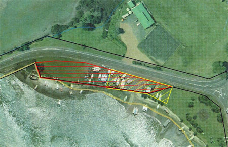
Figure 1: Causeway Road - road stopping and current lease area for the
Waiheke Boating Club
Legend
- larger horizontally hatched area is road to be stopped
- smaller diagonally hatched area is land currently leased to the club
Officers from council's Arts, Community and Recreation Policy group have
advised that once the road has been stopped, the club's lease will be revisited
to ensure that it addresses the needs of the club and the wider community and
that it is consistent with the council's policy on leasing areas of reserve. The
area of road that is proposed to be stopped is larger than that leased to the
club. The additional area will be available for public use and enjoyment and is
better held as recreation reserve than as road. It is noted that the aerial
photo in figure 1 indicates that some of the boats on the hardstand are stored
outside the lease area. It is understood that since this photo was taken some
vessels have been removed and moved to within the leased area. It is still
possible that some are outside the leased area, but these may not be associated
with the club.
The area shown as 'road to be stopped' on figure 1 is shown as primary road
on the planning maps in the proposed Plan, and is therefore not classified with
a land unit. The triangle of land at the eastern end, which is not legal road,
is classified as recreation 1 (local parks). The land used a boat haul out area
is identified in the Plan as contaminated or potentially contaminated land. This
is due to the nature of the activities which have been occurring on the land.
The council's Arts Community and Recreation Policy group is supportive of the
club continuing to operate from this site in an effective and appropriate
manner. Officers from that group have indicated that they would support whatever
land unit achieves this in due course. They have advised that the reserve
management plan for the Ostend Domain, ratified following public consultation in
1987, supports the club's occupation.
It is considered that prior to the road stopping and lease processes being
completed it would be premature for the Plan to classify the land to be leased
to the club with an appropriate recreation land unit. It is therefore
recommended that submission
1254/1 be rejected. However if the road stopping and lease processes are
completed prior to the decisions being completed on these submissions, the panel
should give further consideration to applying a mix of recreation 1 (local parks
and esplanade reserves) and recreation 2 (community facilities and sports parks)
to the land.
Submission
1272/1 seeks to include a land unit for Waiheke specifically covering areas
(a) of exotic trees and / or weeds and / or (b) where mixed species of native
bush is being actively regenerated by landowners - either from what was
previously productive land or from land where the flora was primarily exotic
trees and / or weeds.
Submission
1272/2 seeks to review the proposed land unit categorisations for Waiheke
with a view to applying them more appropriately.
In its supporting reasons, the submission suggests that there are significant
land areas on Waiheke where the dominant flora is either:
- Exotic trees (such as Pinus radiata, Cupressus macrocarpa and Acacia
species) and / or weeds (such as Ulex spp., Solanum mauritanum, Asparagus
scandens, Asparagus asparagoides etc)
- Young regenerating bush perhaps recently planted by landowners, where
kanuka and manuka are not the predominant vegetation.
The submission notes that most of areas appear to have been categorised
principally as landform 6 (regenerating slopes) or landform 7 (forest and bush
areas) and suggests that these land units are not really appropriate. This
submission would appear to be most relevant to the eastern end of Waiheke. The
landform 6 and 7 classifications are not used on the more developed western end.
The landform land units are by their nature broad-brush and may include areas
of land which do not readily fit into the generic descriptions which are found
in the introduction to each land unit. Examples of the generic descriptions are
found at clause 10a.7.1 for landform 6 (regenerating slopes) and clause 10a.8.1
for landform 7 (forest and bush areas) as follows:
" 10a.7.1 Introduction
This land unit is applied to extensive areas of regenerating bush where
kanuka and manuka are the predominant vegetation.
Regenerating slopes is characterised by:
- High natural character and visual amenity value, as a result of its visual
prominence (in both coastal locations and as a backdrop to settlement areas)
and its unbroken expansive qualities.
- Varying rates of regeneration due to differences in factors such as soil
quality and stability, aspect and exposure.
- High ecological values, especially in areas where the regenerating
vegetation has been long established and consequently there is an increased
diversity of podocarp and broadleaf species and wildlife habitats.
- Small, scattered and unobtrusive buildings, if there are buildings at all.
- Isolated pockets of erosion particularly on north facing slopes.
Overall, regenerating slopes makes a significant contribution to the natural
character, ecological and the visual amenity value of the islands."
" 10a.8.1 Introduction
Forest and bush areas include extensive podocarp and broadleaf forest areas,
areas of secondary regenerating forest and some isolated areas of manuka and
kanuka.
Forest and bush areas are characterised by:
- Steep upper slopes and valley systems with some gently sloping areas.
- High conservation and ecological value as these areas have either survived
or significantly recovered from milling activity in the past.
- High natural character and visual amenity due to the sheer dominance,
scale and age of the vegetation cover.
- An absence of built structures.
Overall, forest and bush areas make a significant contribution to the natural
character, conservation, ecological and visual amenity values of the islands."
It is not necessary for every piece of land to fit precisely within the
generic description. Rather the land needs to be considered in its overall
context, and having regard to the objectives, policies and rules applying in the
particular land unit.
It is recommended that submission
1272/1 be rejected as there would be little value added by creating the two
additional land units proposed by the submitter. The related submission
1272/2 should also be rejected.
4.2.2.5 Submission
1289/12
Submission
1289/12 seeks to create a special 'sub-zone' of island residential 2A (bush
residential) for the Walden Family Trust property (being some 42.68ha) at
Onetangi Road. This would provide for a buffer residential land unit as a
transition to rural 1. The submission states that the density under the island
residential 2A land unit should be based on a providing for maximum number of 80
dwellings as a restricted discretionary activity (being discretionary beyond
that). The land unit could potentially be a deferred 'zoning' triggered when the
stated Essentially Waiheke "90% take up rate need trigger" kicks in.
The site referred to in this submission is classified as rural 1 (rural
amenity) in the Plan. Parts of the site are also subject to the rules for
significant ridgeline areas. The location of the site is identified in
appendix 6.
Considerably more investigation would need to be undertaken by the council
before it could be determined whether this land is suitable for more intensive
residential development in the manner sought in the submission. It would be
premature to change the land unit applying to the land until such work has been
done. Further public consultation would also be required. In addition the land
is located outside the metropolitan urban limits for Waiheke as shown in the
Auckland Regional Policy Statement (map 1, sheet 23). Strategic policy
2.5.2(3)(i) of the Regional Policy Statement is as follows:
"expansion of urban activities outside the metropolitan urban limits as
defined and shown in the RPS from time to time is not permitted;"
It would be therefore be contrary to the RPS to reclassify the land for more
intensive residential development.
It is recommended that submission
1289/12 be rejected.
4.2.2.6 Submission
2714/4
Submission
2714/4, from a Great Barrier resident, seeks a return to land use zones,
farm zone, commercial zone (for Great Barrier).
The general nature of this submission makes it difficult to analyse further.
As noted in section 3.0 of this report, all land other than formed roads, is
allocated to either a land unit classification or a settlement area. The
division into land units has been done by grouping land according to common
physical, locational and development characteristics. Some specific locations on
Great Barrier, which warrant a different management approach, are allocated to
settlement areas rather than land units. The land units and settlement areas
applying to Great Barrier do provide for farming and commercial development in
appropriate locations. For instance, farming and horticulture are provided for
as listed activities in the following land units which are found on Great
Barrier:
| Land unit |
Activity status for pastoral farming |
Activity status for horticulture |
| Landform 2 (dune systems and sand flats) |
P
(sand flats area only) |
P
(sand flats area only) |
| Landform 3 (alluvial flats) |
P |
P |
| Landform 5 (productive land) |
P |
P |
| Landform 6 (regenerating slopes) |
- |
P |
| Conservation |
P |
- |
Legend
P = Permitted
Commercial development is primarily provided for in the settlement areas. In
addition, the wharves at Whangaparapara, Port Fitzroy, Tryphena and Okupu are
classified as commercial 7 (wharf).
It is noted that future hearings will consider submissions which seek
specific amendments to the activity lists for the land units and settlement
areas applying on Great Barrier. Similarly, future hearings will also consider
submissions which seek to reclassify land from one land unit classification to
another - for example there are a number of submissions which seek to reclassify
land to landform 3 (alluvial flats) or landform 5 (productive land).
It is recommended that submission
2714/4 be rejected to the extent that it seeks amendments to the Plan.
4.2.2.7 Submission
2763/1
Submission
2763/1 states that land units or areas must be identified according to the
views and perceptions of the affected residents, after performing an open survey
and public consultation on the matter within the existing established 'land
units'. In its supporting reasons, submission
2763/1 suggests that the land units have been created in an arbitrary
manner, without adequate regard to cultural, social and economic considerations
or to the express will of the people affected.
It is recommended that this submission be rejected. As has been noted in
earlier hearing reports, the consultation undertaken by the council prior to
formulation of the Plan met and at times exceeded the requirements of the RMA
and the Local Government Act 2002. The issues raised in consultation were one of
a range of factors taken into account in formulating the land units. It is also
considered that the land units have appropriate regard to cultural, social and
economic factors. In addition, the land units are not a new concept, rather they
build on and refine the approach of the operative Plan.
Submission
2766/4 (from the same submitter as
2763/1) states that the prioritisation or weighting of the four areas of
human well-being (social, economic, cultural and environmental) to which the RMA
and LGA are directed must be duly considered in general, in respect to the
formation of land units, and in respect to specific objectives for such agreed
'units' or localities. Submission
2766/17 states that the council must identify and address the 'issues' from
the proper perspectives for the HGI and for each land unit, policy area or
settlement area.
It is recommended that submissions
2766/4 and
2766/17 be rejected to the extent that they seek amendments to the Plan. The
land units have been considered in the context of section 32 which requires that
objectives be evaluated by the extent to which they achieve the purpose of the
RMA. Policies, rules, or other methods have been evaluated by the extent to
which they are the most appropriate way to achieve the objectives of the Plan.
The purpose of the RMA includes reference to enabling "people and communities to
provide for their social, economic, and cultural wellbeing and for their health
and safety". The four areas of human wellbeing referred to in submission
2766/4 have therefore been appropriately considered.
It is considered that the council has appropriately identified and addressed
issues for each land unit and settlement area.
4.2.2.9 Submission
2932/1
Submission
2932/1, from a Waiheke resident, seeks that the amenity values that make up,
and that might make up, our separate villages are identified, recognised
generally in objectives, policies, assessment criteria and rules and listed in
any activity as discretionary.
It is not clear what amendments, if any, are sought in this submission to
recognise the amenity values associated with the separate villages
[1] on Waiheke. It is considered that the proposed Plan
does appropriately recognise and seek to protect the amenity values of the
villages on Waiheke through the use of the following land units: island
residential 1 (traditional residential), island residential 2 (bush
residential), commercial 1 (Oneroa village), commercial 2 (Ostend village) and
commercial 3 (local shops).
The submission also suggests that it would be inappropriate to establish a
bulk retailer such as The Warehouse on the island as this would be contrary to
existing amenity values. Rather the Ostend facility should be saved for food and
hardware. In using the term 'Ostend facility' it is likely that the submitter is
referring to the vacant land located between Belgium Street and Putiki Road in
Ostend (13-19 Belgium Street and 20-28 Putiki Road). The location of the land is
identified in appendix 6. This land is 1.3ha in size and is classified as
commercial 2 (Ostend village). There are plans to locate a supermarket on this
land, replacing the existing one which is located at 102 Ostend Road.
Retail premises are a permitted activity in commercial 2, but resource
consent would be required for the construction of the associated buildings so
that the scale, form and location can be assessed. The scale of any retail
development would also be limited by the height (8m), building coverage (40%),
and impermeable surface rules set out in part 10c. As well there are specific
front yard requirements and landscape amenity controls applying in commercial 2
(clauses 10a.12.7.4 and 10a.12.7.5).
In terms of the requirements of the RMA, it would be difficult to justify
including a rule in the Plan that limited retail development on the Ostend site
to sale of food or hardware. However it would be possible to control the design
and appearance of buildings on this site to avoid a 'big box' appearance along
the street frontage. This issue will be considered further in the hearing report
on the commercial land units.
It is recommended that submission
2932/1 be rejected to the extent that it seeks amendments to the Plan.
4.2.2.10 Submission
3061/59
Submission
3061/59 seeks changes to the number, type, style and nomenclature of the
land units to reflect the re-structuring of the strategic management areas back
to a catchment framework.
Submission
3061/59 builds on the decision requested in another subpart of submission
3061 (in particular
3061/25) seeking that the strategic management areas be replaced with
catchment based provisions, with specific reference to Waiheke. That subpart has
been considered in an earlier hearing report (see section 4.2.2.1 of the hearing
report on part 3 - Strategic management areas), where officers recommend that it
be rejected. It is noted that submission 3061 has stated that the strategic
management areas for Waiheke in the operative Plan are 'catchment based'. This
is not correct if catchment is taken in its strict technical sense to refer to
water catchments which are based on areas of land or topography from which
surface water flows via a self-contained drainage system. However it may be that
the submitters are using the term 'catchment' in a more general sense and are
referring to the differences between western Waiheke (which is a more urban
'catchment') and eastern Waiheke (which is a more rural 'catchment').
The use of the term 'catchment' by the submission appears to have its origins
in an Auckland City document from the early 90s entitled A summary review on
the preparation of the Plan. This document was prepared to support the
proposed Plan notified in 1992. The document uses the term 'catchment', but at
times the term is used in a generalised manner and it is clear that the meaning
is not limited to physical water catchments. For instance, page 12 of the
document uses the term 'catchment boundaries' when describing the way in which
Waiheke and Great Barrier have been divided into strategic management areas. It
then goes on to clarify that on Waiheke the strategic management areas recognise
major urban / rural identity areas while on Great Barrier the strategic
management areas relate entirely to catchment systems (due to the predominantly
rural / natural state of the landscape as a whole).
The operative Plan has two strategic management areas for Waiheke - the
western Waiheke strategic management area, and the eastern Waiheke strategic
management area. The division between the western and eastern strategic
management areas is defined by a line joining the eastern end of Onetangi Bay on
the north coast with the eastern end of Omiha (Rocky Bay) on the south coast.
The boundary between the strategic management areas defines the separation
between the major areas of urban (western Waiheke) and rural (eastern Waiheke)
activities.
The proposed Plan adopts a similar approach to the operative Plan. The
proposed Plan has only one strategic management area for Waiheke but it
continues to differentiate between western and eastern Waiheke. The boundary
between western and eastern Waiheke is identified on figure 3.1 of the proposed
Plan and is identical to that contained in the operative Plan.
If the strategic management areas for Waiheke in the operative Plan are
considered to be catchment based, then the strategic management area for Waiheke
in the proposed Plan must also be considered to be catchment based. Both the
operative and the proposed Plan differentiate between western and eastern
Waiheke.
It is recommended that submission
3061/59 be rejected, as there is no need to make any changes to the land
units to reflect the restructuring of the strategic management areas back to a
catchment framework.
It is noted that the operative Plan has two types of land units:
- landscape based land units (land units 1 -10)
- activity based and special land units (land units 11-27).
The proposed Plan has a similar approach:
- landscape based land units (landforms 1-7)
- activity based and special land units (island residential 1-2, commercial
1-7, Matiatia (mixed use), recreation 1-3, rural 1-3, conservation, Rotoroa
and Pakatoa).
Submission
3726/2 (from the same submitter as submissions 2763 and 2766) seeks that for
each proposed area or land unit, a comprehensive and coherent set of proposed
issues, objectives, policies, etc be provided so that people can participate
effectively in the evaluation and review of the views of council's experts.
Submission
3726/3 seeks that the proposal for each area include:
- Proposals for each land unit (as per section 10 etc), including settlement
areas
- A transparent and clear list of activities which are not permitted (as per
the operative Plan)
- The proposed subdivision rules and minimum site areas
- Applicable developments controls
- Applicable heritage and other rules
- Other information necessary for understanding the policies and rules
applicable to each area and community
- The specific weighting or significance to be applied to each criterion
provided in policies and rules.
Submission
3726/4 seeks that each section relating to an area or land unit state the
changes proposed, the reason for the changes, and the rejected alternatives,
including doing nothing, with reasons.
Another subpart of submission 3726 (ie submission
3726/1) seeks that the Plan be rewritten. Submissions
3726/2,
3726/3, and
3726/4 follow on from that position and suggests how the council could then
present information about each area or land unit so as to enable effective
public participation. Submission
3726/1 has been considered in an earlier hearing report (see section 3.6 of
the hearing report on the whole Plan) and officers recommended that it be
rejected. It is recommended that submissions
3726/2,
3726/3,
3726/4 also be rejected. As has been noted in section 4.2.2.3 of this
reports, adequate consultation was undertaken by the council prior to the
formulation of the Plan.
Planner's recommendations for submissions about the format
and layout of the land units and settlement areas
- That submission
821/38 be accepted.
- That submissions
1199/3,
1254/1,
1272/1,
1272/2,
1289/12,
2714/4,
2763/1,
2766/4,
2766/17,
2932/1,
3061/59,
3726/2,
3726/3,
3726/4 be rejected.
|
4.3 Submissions about activities and activity statuses
Submissions dealt with in this section:
358/4,
358/5,
618/49,
618/50,
618/55,
619/15,
619/16,
619/18,
754/16,
754/17,
754/19,
754/20,
852/4,
859/16,
859/19,
859/20,
1074/2,
1101/25,
1101/26,
1101/31,
1125/1,
1175/1,
1243/70,
1243/72,
1282/1,
1287/31,
1287/32,
1287/37,
1289/32,
1289/33,
1289/38,
1350/1,
1355/1,
1453/1,
1465/1,
1470/1,
1489/1,
1514/1,
1896/1,
1896/2,
2243/1,
2273/1,
2488/1,
2670/15,
2670/16,
2670/17,
2670/18,
2670/19,
2721/6,
2861/1,
3583/5,
3611/2,
3636/1,
3671/1,
3757/1
4.3.1 Decisions requested
The submissions considered in this section seek decisions which:
- amend the activity tables for all land units and landforms so they clearly
provide for residential uses as permitted activities
- provide for new buildings or additions to existing buildings as a
controlled activity in all places where the Plan makes them restricted
discretionary activities
- if the restricted discretionary status is to remain for new buildings and
alterations, then modify the application of the ridgeline rules
- provide for all new buildings in residential areas as controlled
activities with visual impact criteria included in the amended provisions.
Provide for buildings not meeting these requirements as restricted
discretionary activities
- classify residential as a controlled activity in residential land units,
subject to compliance with all development standards. If the development
standards are not complied with, the residential activity should be classified
as a restricted discretionary activity
- provide for emergency service facilities as permitted activities in
appropriate land units and settlement areas
- include appropriate clauses recognising all existing paths, walkways, bush
tracks, tracks, driveways, quad-bike tracks, accessways as existing uses or
permitted activities within each landform description and tables, and in
settlement areas
- amend the statuses for all activities on Great Barrier
- limit the restricted discretionary status to exceptional situations and
features, and only impose in full consultation with the local Great Barrier
community
- replace the prescriptive activity lists and default non-complying status
with an 'effects based' approach
- amend the proposed list of activities for 'rural zones'
- amend the proposed list of activities (as set out in submission
2721/6)
- ensure that consent for function facilities includes proper mitigation
controls physically containing the activity and noise
- provide for bridle paths in landforms 1-7, recreation 1-3, and rural 1-3
- provide for continuous canopy native forestry as a permitted activity in
rural land units
- provide for agriculture and forestry as permitted activities in all
landform and rural land units
- include an intrinsic 'right to farm' in the rules governing all rural and
rural amenity land units
- provide for rural property management plans in all landform and rural land
units as discretionary activities
- provide for helipads as a discretionary activity in all rural land units.
4.3.2 Planner's analysis and recommendations
4.3.2.1 Residential uses (submission
618/49 and others)
Submissions
618/49,
754/16,
859/16,
1101/25,
1287/31,
1289/32,
2670/15 seeks that the activity tables for all land units and landforms be
amended so they clearly provide for residential uses as permitted activities -
as a dwelling is a building and not a use. Submission
619/15 seeks a similar decision but includes specific reference to landform
5 (productive land).
This submission suggests that all the activity tables for the land units need
to clearly provide for residential uses as a permitted activity. This option was
considered during the drafting of the Plan. However the approach that was taken
was to provide for 'dwelling (one per site)' as a permitted activity in land
units and settlement area where residential uses are provided for. The
definition of 'dwelling' contained in part 14, and the related definition of
'household unit'
are intended to provide for residential uses. However it is acknowledged that
the linkage between dwellings and the associated residential uses could be
clearer and for this reason the council has lodged a submission (
2096/4) which seeks to amend the definition of dwelling by adding a sentence
which states "It also includes the use of land for uses ancillary or incidental
to a dwelling". Submission
2096/4 will be considered in the hearing on part 14. The amendment suggested
in this submission would meet the concerns raised in submission
618/49 and others. For this reason it is recommended that these submissions
be rejected.
4.3.2.2 Buildings and controlled activities
Submissions
754/17,
1101/26,
1287/32,
1289/33 and
2670/16 seek that the activity tables for all land units and landforms be
amended so that new buildings or additions to existing buildings are provided
for as a controlled activity in all places where the Plan makes them restricted
discretionary activities. Submissions
618/50 and
619/16 seeks a similar decision but also make specific reference to landform
5 (productive land).
Some of these submissions (
618/50,
619/16 and
2670/16) also suggest that where buildings do remain (following
determinations on submissions) as restricted discretionary activities then where
there are ridgeline rules applying to such land then that additional development
control should be deleted as the restricted discretionary criteria can be
amended to include proper consideration of location and visual impact matters.
Submission
1125/1 and
1282/1 seek to amend the Plan provisions so that all new buildings in
residential areas are controlled activities with visual impact criteria included
in the amended provisions. Submission
1125/1 also seeks to provide for any development not meeting those
requirements as a restricted discretionary activities.
It is recommended that submissions which seek a controlled activity status
for buildings be rejected as buildings have been appropriately provided for as a
restricted discretionary activity (rather than a controlled activity) in those
land units and settlement areas where there is a need for the council to more
carefully assess the scale, form, colour and location of buildings.
Issues with controlled activity status
During the formulation of the Plan, the council reached the view that the
controlled activity status was not appropriate for any of the activities
identified in the Plan. In the past, the council has used the controlled
activity status in the Isthmus Plan, the Central Area Plan and in the operative
Hauraki Gulf Islands Plan. Considerable experience in administering these Plans,
together with the development of case law, has led council to the view that, in
the main, the use of the controlled activity status does not provide the council
with sufficient discretion to address the potential adverse effects associated
with particular proposals. The council cannot decline an application for a
controlled activity. While the council may impose reasonable conditions that
relate to the matters over which it has reserved control, it cannot impose
conditions which require such significant modification as to fundamentally alter
the proposal. To do so would effectively negate the consent granted and prevent
the activity from taking place. Not all proposals which warrant assessment
through the resource consent process can be adequately mitigated by the use of
conditions. Some proposals need to be declined or substantially modified. The
controlled activity status should be reserved for situations where the council
is confident that every proposal should be consented to and that adverse effects
can be adequately addressed via conditions without substantial modification to
the original proposal. While the controlled activity approach does provide
greater certainty to applicants, this needs to be balanced against the need to
ensure good environmental outcomes.
Comparison between proposed and operative Plans
There has been a well considered change in approach between the proposed and
the operative Plans in terms of the activity status applied to the construction
of buildings (including alterations and additions) in the more sensitive land
units. The operative Plan relies on the controlled activity status for dealing
with construction of buildings (including alteration and additions) in some land
units ie land units 11, 12, 17, 18, 19, 20, 21, 22, 23, 24 and 25. The proposed
Plan instead applies the restricted discretionary status to the construction of
buildings (including alterations and additions) in some land units and parts of
settlement areas. This is consistent with policies in the Plan about ensuring
that the scale, form (design and materials), colour and location of buildings do
not have adverse effects on the character and amenity values of the more
sensitive land units and settlement areas. It is considered that continuing with
the approach in the operative Plan of relying on a controlled activity status
would not give the council sufficient certainty that these critical policies
could be achieved. At times it may be necessary to require considerable
modifications to a building or decline a particular building in a particular
location. For this reason the restricted discretionary status is preferred and
is considered to be more consistent with achieving the purpose of the RMA.
Not all activities which were controlled in the operative Plan have been
moved into the restricted discretionary status in the proposed Plan. In some
cases, building work which was identified as a controlled activity in the
operative Plan is now a permitted activity in the proposed Plan. This has
occurred for properties which are within the Tryphena or Claris policy areas in
the operative Plan and are within the residential amenity part of the Tryphena
or Claris settlement areas or within the light industry part of the Claris
settlement area in the proposed Plan.
Relationship with ridgeline controls
Submission
2670/16 also suggests that where the council decides that buildings should
remain as restricted discretionary activities, then where the ridgeline rules
apply, those additional rules should be deleted. The restricted discretionary
criteria should instead be amended to address those matters which would
otherwise be assessed under the ridgeline rules. It is noted that this matter
will also be considered in the hearing report for part 10c as it has been raised
in other submissions (
754/18 and
859/18) which will be considered at that time.
For buildings as a restricted discretionary activity, the matters of
discretion to be considered by the council are identified in clause 11.5. The
matters of discretion are limited to:
- scale
- form (design and materials)
- colour (except that this matter will not be considered in commercial 1 and
2)
- location
- any relevant open space strategy or reserve management plan (for
recreation 1-3 only).
The notification requirements set out in clause 11.5.1 provide that
applications for buildings as a restricted discretionary activity will be
considered without notification.
Any building which infringed the ridgeline control set out in clause 10c.4.7
would be considered as a discretionary activity. The council's assessment would
include consideration of the assessment criteria set out in clause 10c.3.1.
Those matters are general, and are not specific to ridgeline infringements.
However clause 10c.3.1(3) does require the assessment to consider whether the
development remains consistent with the intention of the development control it
infringes having regard to the explanation given in the Plan for the particular
control. The explanation given in clause 10c.4.7 Ridgeline control, is as
follows:
" Explanation
Buildings that protrude above significant ridgelines can compromise the
visual landscape qualities of the ridge and appear visually obtrusive giving
rise to adverse visual effects. The location and height of buildings within 100m
either side of a significant ridgeline is therefore controlled to manage the
adverse visual impact that can occur when a building protrudes above the
ridgeline."
If the approach suggested in submission
2670/16 was adopted, an infringement of the significant ridgeline control
would be treated as follows:
- If the building does not require consent as a restricted discretionary
activity, then the ridgeline infringement would be treated as a discretionary
activity.
- If the building did require consent as a restricted discretionary activity
then the ridgeline infringement would be considered as part of that consent.
It would not be treated as a discretionary activity.
If the approach currently in the Plan was retained, where a building did
require consent as a restricted discretionary activity, but it also infringed
the ridgeline rule (which is a discretionary activity) then the entire proposal
would be assessed as a discretionary activity.
The submitter's suggestion is not supported as it is difficult to justify
effectively changing the status of a ridgeline infringement from discretionary
to restricted discretionary just because the building itself is otherwise
restricted discretionary.
However this submission does raise the issue as to whether a restricted
discretionary status would be more appropriate for a ridgeline infringement. The
matters of discretion could be limited to scale, form (design and materials),
colour and location (including the screening effects of any existing
vegetation). This a matter that will be considered further in the hearing report
for part 10c. There are a wide range of submissions to the ridgeline control,
including some which seek a restricted discretionary status for proposals which
do not comply with the permitted activity standard.
4.3.2.3 Residential activities
Submission
358/4 seeks that residential activity be classified as a controlled activity
in residential land units, subject to compliance with all development standards.
Submission
358/5 states that if the development standards are not complied with, the
residential activity should be classified as a restricted discretionary
activity, with assessment criteria restricted to the matters of non-compliance
with those standards and the matters set out in clause 10c.5.7 (as proposed to
be amended elsewhere in submission 358).
It is not entirely clear what these submissions are seeking. They are found
in a part of the overall submission 358 which deals with part 10c - Development
controls for land units and settlement areas. However the reference to
residential activity which complies with all development standards being
provided for as a controlled activity is more relevant to the activity tables
for the land units in part 10a of the Plan.
It is noted that another subpart of submission 358 (ie
358/3) specifically seeks that residential activities (listed as the first
and second activities in the activity table in clause 10a.10.5) that meet the
development standards be reclassified as controlled activities in island
residential 2 (bush residential). That submission will be considered in the
hearing report on the island residential land units.
Controlled activity status for residential activity complying with
development standards
In using the term 'residential activity' it appears that the submission is
referring to the fact that buildings and additions are provided for as a
restricted discretionary activity in many land units. This means that resource
consent would be required to construct or alter a dwelling and associated
residential accessory buildings. This issue has already been addressed in
section 4.3.2.2 of this report. For the reasons set out previously, use of the
controlled activity status is not supported. It is therefore recommended that
submission
358/4 be rejected.
Restricted activity status for residential activity not complying with
development standards
Submission
358/5 appears to seek greater use of the restricted discretionary activities
in part 10c. Clause 10c.3.1 provides that unless otherwise specified an
application to infringe one or more of the development controls in part 10c, or
part 10a or part 10b, is a discretionary activity. Part 10c does provide for
some types of development control modification to be considered as a restricted
discretionary activity. In particular, the following development control
modifications are restricted discretionary activities:
- the use of exterior building materials in settlement areas which do not
comply with the permitted activity standards
- an infringement of the impervious surface area controls
- some types of vegetation removals
- some types of earthworks.
It is considered that both the restricted discretionary and the discretionary
category have been appropriately used in part 10c. Submission
358/5 expresses particular concern about clause 10c.5.7 which contains rules
for coastal, wetland and water body protection yards.
Recommendation
It is recommended that submission
358/4 be rejected.
4.3.2.4 Emergency service facilities (submission
1074/2)
Background
Submission
1074/2, from the NZ Police, seeks amendments to the Plan to provide for
emergency service facilities as permitted activities in appropriate land units
and settlement areas. The submission does not explain what sort of activities
would be encompassed by the term 'emergency facilities' but does refer to
particularly to police stations. It is not clear whether police stations are the
extent of the submitter's concern.
The submission notes that no specific provision has been made for emergency
services but suggests that police stations could fit within the definition of
offices or community facilities contained within part 14 of the Plan. Offices
and community facilities are defined as follows:
" Offices means land or buildings used for administration,
consultation, or management of business transactions.
It includes any of the following:
- Administrative offices for managing the affairs of an organisation,
whether or not trading takes place.
- Commercial offices such as banks, insurance agents, or real estate agents
where trade (other than the immediate exchange of money for physical goods) is
transacted.
- Professional offices such as the offices of accountants, solicitors,
architects, engineers, surveyors, stockbrokers and consultants where a
professional service is available and carried out. This does not include
healthcare services."
" Community facilities means land or buildings used for community or
public use and run on a not-for-profit basis.
It includes places used for the gathering of people for recreation, worship,
cultural and spiritual instruction and deliberation, public halls and libraries.
It does not include any of the following:
- entertainment facilities
- healthcare services
- restaurants, cafes and other eating places."
Offices or community facilities are provided for as listed activities in the
following land units and settlement areas:
| Land unit or settlement area |
Activity status listed for community facilities |
Activity status listed for offices |
| Island residential 1 (traditional residential) |
D |
D |
| Island residential 2 (bush residential) |
D |
D |
| Commercial 1 (Oneroa village) |
P |
P |
| Commercial 2 (Ostend village) |
P |
P |
| Commercial 3 (local shops) |
D |
- |
| Matiatia (mixed use) - within the mixed use area shown on
figure 10a.1 |
P
(subject to threshold control) |
P
(subject to threshold control) |
| Recreation 2 (community facilities and sports parks) |
P |
- |
| Recreation 3 (Rangihoua Park) |
P in area A and D, D in area E |
- |
| Pakatoa - within the tourist complex area |
- |
P |
| Tryphena, Medlands, Claris, Okupu, Whangaparapara, Awana,
Okiwi, Port Fitzroy and Aotea settlement areas - within the residential
amenity areas
|
P |
D |
| Tryphena, Claris and Port Fitzroy settlement areas - within
the local retailing areas |
P |
P |
| Claris settlement area - Claris airport area |
- |
P |
Legend
P = Permitted
D = Discretionary
The minister of police has the power to designate sites for police purposes
and therefore does not need to rely on the standard provisions of the Plan. The
minister of police has designated the following three sites in the islands:
| Description and site |
Map reference |
Land unit classification |
Waiheke Island Police Station
21-23 Waikare Road |
2-9 |
Island residential 1 (traditional residential) |
Waiheke Island Police Station
104 Ocean View Road |
2-12 |
Commercial 2 (Ostend village) |
Great Barrier Island Police Station
175 Hector Sanderson Road
|
54-10 |
Landform 3 (alluvial flats) |
Another subpart of submission 1074 (ie
1074/1) requests that a definition for emergency service facilities be
included in part 14 of the Plan. Submission
537/17 from the NZ Fire Service Commission also requests a definition for
emergency service facilities. Both these submissions (
1074/1 and
537/17) will be considered in the hearing report on part 14. There are also
submissions from the NZ Fire Service Commission (
537/5,
537/7,
537/9,
537/10) seeking that emergency service facilities be provided for as a
permitted activity in some land units and parts of settlement areas. Those
submissions will be considered in other hearing reports.
Recommendation
It is acknowledged that the Plan could make better provision for some
emergency service facilities - in particular police stations, ambulance stations
and fire stations. These activities do not readily fit into any of the existing
definitions in part 14 of the Plan. It is noted that medical emergency services
such as hospitals and doctors' surgeries fit within the definition of healthcare
services and are therefore appropriately provided for in the Plan.
As noted above, the minister of police has been able to designate land for
police stations in the islands. However the authorities responsible for
ambulance and fire stations do not have the ability to designate land as they
are not requiring authorities under the RMA. Emergency service facilities are
critical for the health and safety of the community and as such they should be
clearly provided for in appropriate land units and settlement areas.
In order to make better provision for emergency service facilities, one
option is to broaden the definition of community facilities to specifically
include police stations, ambulance stations and fire stations. However this
approach is not recommended as the definition currently focuses on activities
which involve the gathering of people. Emergency service facilities are likely
to have particular characteristics and effects which differ from those of
activities which involve the gathering of people. Many emergency service
facilities involve some degree of 24 hour operation which can be disruptive to
surrounding uses. They may also have particular access requirements so that
emergency vehicles can exit quickly and safely.
It is therefore recommended that a separate definition for emergency service
facilities be added to part 14 of the Plan. As noted above, this matter will be
raised again in later hearing reports - particularly the report on part 14.
However it also needs to be considered now, as the activity cannot be
appropriately provided for unless a definition is also determined. The NZ Fire
Service Commission has suggested the following definition (in submission
537/17):
" Emergency services facilities means those facilities or authorities
which are responsible for the safety and physical welfare of the people or
property in the community and includes fire stations, ambulance stations and
police stations."
However this definition is considered to be too broad as it is not confined
to fire stations, ambulance stations and police stations. The following
definition is instead recommended:
" Emergency services facilities means land and buildings used for a
fire station, ambulance station or police station. This may include
administration, vehicle and equipment storage and maintenance, and training."
It is recommended that emergency services facilities be provided for as a
listed activity in the following land units and settlement areas:
| Land unit or settlement area |
Status |
| Landform 3 (alluvial flats) |
d |
| Island residential 1 (traditional residential) |
d |
| Island residential 2 (bush residential) |
d |
| Commercial 1 (Oneroa village) |
rd |
| Commercial 2 (Ostend village) |
rd |
| Commercial 5 (industrial) |
rd |
| Settlement areas - within the residential amenity areas,
and the local retailing areas |
D |
Legend
P = Permitted
RD = Restricted discretionary
D = Discretionary
NC = Non-complying
In commercial 1, 2 and 5, where use of the restricted discretionary status is
recommended, the council should restrict its discretion to considering the
following matters:
- access for emergency vehicles
- noise
- the reverse sensitivity effect of the activity on existing industrial
activities (for commercial 5 only).
Table 11.1: Assessment criteria for particular discretionary activities, will
also need to be amended. 'Emergency services facilities' should be added, with
all items (1 to 18) identified with an asterisk.
4.3.2.5 Recognition of existing paths etc on Great Barrier
Submissions
1350/1,
1355/1,
1453/1,
1465/1,
1470/1,
1489/1,
1514/1,
2243/1,
2273/1,
2488/1,
2861/1,
3636/1 and
3671/1 seek inclusion of appropriate clauses recognising all existing paths,
walkways, bush tracks, tracks, driveways, quad-bike tracks, accessways as
existing uses or permitted activities within each landform description and
tables, and in settlement areas. Submission
3757/1 seeks similar amendments. These submissions are all from Great
Barrier residents or landowners.
It is acknowledged that there are some long standing problems of access for
private properties on Great Barrier. However the suggestion that all existing
paths, walkways, bush tracks, tracks, driveways, quad-bike tracks, accessways
should be recognised in the Plan as existing uses or permitted activities is not
supported. In some cases the continued use of existing accessways will be
protected by the existing use rights provisions of section 10 of the RMA. In
other cases, the construction of accessways may have been permitted by a
particular resource consent or subdivision consent and it is appropriate that
they remain subject to the conditions of that consent rather than being provided
for as a permitted activity. There are likely to be some accessways which do not
have existing use rights as they were not legally established.
It is recommended that submissions
1350/1,
1355/1,
1453/1,
1465/1,
1470/1,
1489/1,
1514/1,
2243/1,
2273/1,
2488/1,
2861/1,
3636/1 and
3671/1 be rejected.
4.3.2.6 Activity statuses on Great Barrier
Submission
1564/1 seeks that all rules and activity tables for landforms 1 to 7 on
Great Barrier and settlement areas be amended so that all non-complying
activities become restricted discretionary, and all restricted discretionary
activities become discretionary, and all discretionary activities become
permitted. All permitted activities should remain permitted. Submission
1896/1 seeks similar amendments to all tables for activities and land use
restrictions for Great Barrier. Submission
1896/2 further suggests that the restricted discretionary status should be
limited to exceptional situations and features, and be imposed in full
consultation with the local Great Barrier community.
It is likely that the submitters have misunderstood the hierarchy of
activities when it comes to discretionary and restricted discretionary
activities. The discretionary category is a more rigorous and onerous
requirement than restricted discretionary. However what it clear is that the
submissions seek to liberalise the resource consent requirements for activities
on Great Barrier.
In general terms the activity statuses applied to the various land units and
settlement areas on Great Barrier are considered appropriate. There may be
specific instances where the status applied to a particular activity in a
particular land unit or settlement area warrants further consideration, however
this submission does not identify any. The Plan applies the restricted
discretionary status where the potential effects of an activity warrant
consideration via a resource consent application but where the matters of
concern can be restricted. In most cases, the Plan also expressly provides for
restricted discretionary activities to be processed without service of notice or
public notification. The Plan applies the discretionary activity status where a
more comprehensive assessment of potential effects is required. The
non-complying activity status applies to activities which, due to their
potential effects, do not appropriately fall into the permitted, restricted
discretionary, or discretionary activity category.
It is recommended that submissions
1564/1,
1896/1 and
1896/2 be rejected.
It is noted that other reports will consider submissions which seek to amend
the status of specific activities in specific land units.
4.3.2.7 Prescriptive activity lists
Submission
2670/17 asks the council to delete the approach taken in the Plan
(specifically in part 10) to managing activities through prescriptive activity
lists and then deeming all activities outside of such lists to be non-complying.
The submission seeks to replace this prescriptive approach with an effects based
approach similar to the operative Plan. Submissions
754/19 and
859/19 seek a similar decision. Submission
2670/17 also suggests that the council retain and restructure the current
effects based approach of the operative Plan (amending existing discretionary
use lists taking into account monitoring feedback on administration of the
operative Plan for the last 10 years).
The proposed Plan adopts an approach of listing specific activities as either
permitted, restricted discretionary or discretionary in particular locations. In
some situations (eg table 7.2), non-complying and prohibited activities are also
specifically listed in the Plan. The general rule contained in clause 4.2
applies a non-complying status to activities not otherwise provided for as
permitted, controlled, restricted discretionary or discretionary. Also included
in the Plan are development controls which apply to all activities.
The approach taken in the operative Plan is, in general, to state in each
land unit that an activity that complies with the standards in part 6B of the
Plan is permitted unless it is otherwise provided for in the rules for the
particular land unit as a controlled, discretionary or prohibited activity.
Those activities which have been identified for a particular land unit as having
the potential to generate adverse effects which need to be specifically
addressed are identified as either controlled or discretionary activities. There
also is a general rule in part 2.2 stating that an activity which contravenes a
rule in the Plan, but which is not a prohibited activity, is a non-complying
activity.
The standards in part 6B of the operative Plan address:
- infrastructure and services (including effluent disposal; parking, access,
traffic generation, roading and aircraft movements)
- bulk and location of buildings (height, daylight control, lot yards, lot
coverage, gross dwelling area, ridgeline control)
- conservation amenity (sites of ecological significance, indigenous
vegetation clearance, hazard areas, noise, earthworks, protection yards,
building restriction yards, artificial lighting, and hazardous substances).
It is noted that the approach now taken in land unit 27 (Matiatia) of the
operative Plan (as introduced by plan change 38) is to list activities in a
similar manner as the proposed Plan.
The approach taken in the operative Plan is sometimes described as 'effects
based'. However it is considered that this description is misleading and
unhelpful as the purpose of all district plans is to assist territorial
authorities to carry out their functions including "the control of any actual or
potential effects of the use, development, protection of land" (s31(1)(b) of the
RMA). Neither is the approach taken in the operative Plan based solely on
performance standards as that Plan does identify a consent status for certain
activities. To differing degrees, both the operative and proposed Plan allocate
particular activities to a specific activity status based on the potential of
those activities to generate adverse effects.
The following difficulties have been identified with the operative Plan:
- The performance standards in part 6b relating to traffic and parking are
inadequate, and in some cases, ultra vires [2] . They
are inadequate as a basis for determining whether or not an activity not
otherwise listed is permitted.
- There are relatively few activities listed in the land units as controlled
or discretionary. Sometimes activities with potentially adverse effects
qualify as permitted while activities with lesser effects require a consent.
- The approach does not recognise the value of grouping or separating
certain types of activities. For example, there are good resource management
reasons for separating residential activities from industrial and commercial
activities.
- The approach relies too heavily on performance standards and gives little
indication about the activities considered suitable (ie permitted) for each
land unit or policy area.
- Those activities which are listed as controlled or discretionary are
sometimes poorly described by the definitions in part 11 of the Plan.
It is recommended that submissions
754/19,
859/19 and
2670/16 be rejected as it is considered that the prescriptive approach taken
to activity lists in the proposed Plan is appropriate. The approach taken has
satisfactorily addressed these difficulties experienced with the operative Plan
without unduly creating other complexities. It has also avoided the complication
which occurs with some district plans whereby a comprehensive and complicated
range of performance standards need to be considered before it can be determined
whether or not an activity is permitted. It is acknowledged that people who are
used to the operative Plan, and who have not used plans with more extensive
activity lists, may find the new approach somewhat intimidating.
4.3.2.8 Suggested activity lists for rural zones
The submissions considered in this section seek various activity lists for
the 'rural zones' or rural land units. It is not clear whether the submissions
are referring to only the rural 1-3 land units, or whether the term 'rural
zones' is intended to encompass the landform 1-7 land units as well. Given the
location of the submitters' properties [3] it is likely
that the main interest is in rural 1 and 2 which occur only on western Waiheke.
The table below summarises the activity lists sought in these submissions:
| Activity |
Column 1
(
618/55,
1101/31,
1289/38)
Status |
Column 2
(
619/18,
754/20,
859/20,
2670/18)
Status |
Column 3
(
1287/37)
Status |
| Art galleries and museums |
RD |
RD |
RD |
| Cafes/restaurants |
RD |
RD |
RD |
| Care centres |
RD |
RD |
RD |
| Churches and places of worship, and church towers |
RD |
- |
- |
| Clustered residential developments |
RD |
- |
RD |
| Comprehensive management plans (or rural property
management plans dependant on relief granted for other submissions) |
D |
- |
D |
| Disposal of treated wastewater |
RD |
- |
RD |
| Educational facilities |
D |
RD |
D |
| Exotic forestry |
D |
- |
- |
| Farm buildings |
C |
RD |
C |
| Function facilities |
D |
RD |
D |
| Grape growing |
P |
- |
- |
| Helipads |
D |
- |
D |
| Indigenous plantation forestry |
P |
- |
- |
| Integrated visitor development |
D |
RD |
D |
| Management and enhancement activities that facilitate
wetland management |
RD |
- |
RD |
| Minor dwellings |
RD |
- |
RD |
| Open air markets |
RD |
RD |
RD |
| Outdoor recreation/adventure activities |
RD |
RD |
RD |
| Residential use |
P |
RD |
P |
| Rural property management plans |
- |
RD |
- |
| Sustainable farming and land management |
P |
- |
P |
| Tourist complexes |
D |
RD |
D |
| Windmill towers to 15m for generation of electricity |
RD |
- |
- |
| Wineries |
RD |
RD |
RD |
Legend
P = Permitted
RD = Restricted discretionary
D = Discretionary
Submissions
618/55,
1101/31,
1289/38 seek the activity list from column 1 of the table above for all for
all rural zones as well as for the submitter's land specifically. The land
belonging to these submitters is as follows:
- 205 Church Bay Road -
618/55
- Obsidian vineyard, Te Makiri Road -
1101/31
- 73 Onetangi Road (either where it remains rural 1 or is rezoned
residential 2a as sought in submission) -
1289/38
The submissions state that the activity tables should be amended to include
activities identified in addition to those already in the proposed activity
tables.
Submissions
619/18,
754/20,
859/20,
2670/18 seek the activity list from column 2 of the table above for all
rural land units.
Submission
1287/37 seeks the activity list from column 2 of the above table for all
rural zones as well as for the submitter's land specifically (at 306 Sea View
Road, Thompsons Point, whether or not it is reclassified as sought). The
submission states that the activity tables should be amended to include the
identified activities in addition to those already in the proposed activity
tables.
The location of the sites referred to above is identified in appendix 6.
Rural 1 and 2 activity lists
The activity lists for rural 1 and 2 provide for the following activities:
| Activity |
Rural 1
Status |
Rural 2
Status |
| The construction and relocation of buildings, including
buildings used for any of the other activities listed in this table |
RD |
RD |
| Alterations and additions to the exterior of existing
buildings including buildings used for any of the other activities listed in
this table. However this does not apply to minor alterations and additions
as defined in part 14 - Definitions |
RD |
RD |
| Dwelling (one per site) |
P |
P |
| Entertainment facilities within the Onetangi Road area
identified on figure 10a.2 |
D |
- |
| Function facilities within the Onetangi Road area
identified on figure 10a.2 |
D |
- |
| Home occupations |
P |
P |
| Homestay |
P |
P |
| Horticulture |
P |
P |
| Multiple dwellings |
P |
- |
| Pastoral farming |
P |
P |
| Residential accessory buildings |
P |
- |
| Restaurant, cafe and other eating places within the
Onetangi Road area identified on figure 10a.2 |
D |
- |
| Tourist complex within the Onetangi Road area identified on
figure 10a.2 |
D |
- |
| Visitor accommodation for more than 10 people |
D |
D |
| Visitor accommodation for up to 10 people |
P |
P |
| Winery within the Onetangi Road area identified on figure
10a.2 |
D |
- |
Legend
P = Permitted
RD = Restricted discretionary
D = Discretionary
Assessment of the additional activities proposed
There are other submissions which seek to amend the activity lists applying
in rural 1 and / or 2. Most of those submissions will be considered in the
hearing report on rural 1 and 2. For this reason no firm recommendation is given
on these submissions at this time. Rather the panel should consider its position
on these submissions following completion of the hearings on rural 1 and 2.
However, to assist the panel, and the submitters, a limited assessment of the
merits of the activities sought in these submissions is provided in the table
below. Where an activity is identified in the table as 'not considered
appropriate' in a particular land unit (or part of a land unit), this is due to
the likely scale and effects, and consistency with the objectives and policies
of the land unit.
| Activity |
Assessment |
| Art galleries and museums |
Not considered appropriate as a listed activity for rural 1
and 2 |
| Cafes/restaurants |
Appropriately provided for as a discretionary activity in
the Onetangi Road area of rural 1. Not considered appropriate as a listed
activity elsewhere. |
| Care centres |
Not considered appropriate as a listed activity for rural 1
and 2. |
| Churches and places of worship, and church towers |
Not considered appropriate as a listed activity for rural 1
and 2.
Note: this term is not defined in the Plan or used elsewhere in the Plan.
It would fit within the definition of community facilities. |
| Clustered residential developments |
In rural 1, clause 12.9.4 already provides for cluster
subdivision associated with the protection of significant environmental
features. |
| Comprehensive management plans (or rural property
management plans dependant on relief granted for other submissions) |
Considered in section 4.4 of this report. |
| Disposal of treated wastewater |
It is not clear what this activity is intended to cover.
|
| Educational facilities |
Not considered appropriate as a listed activity for rural 1
and 2. |
| Exotic forestry |
Not considered appropriate as a listed activity for rural 1
and 2.
Forestry is also considered in section 4.3.2.11 of this report. |
| Farm buildings |
The status of farm buildings does need to be clarified.
Submission
560/18, which will be considered in the hearing report on part 14 -
Definitions, seeks to amend the definition of pastoral farming to include
the use of accessory buildings. This approach is preferred as it will
clarify the status of farm buildings in all land units where pastoral
farming is provided for. |
| Function facilities |
Appropriately provided for as a discretionary activity in
the Onetangi Road area of rural 1. Not considered appropriate as a listed
activity elsewhere. |
| Grape growing |
Included within the definition of horticulture which is
already a permitted activity in rural 1 and 2. |
| Helipads |
Considered in section 4.3.2.11 of this report. |
| Indigenous plantation forestry |
Not considered appropriate as a listed activity for rural 1
and 2 due to the adverse effects associated with extraction.
Continuous canopy native forestry is also considered in section 4.3.2.11
of this report. |
| Integrated visitor development |
Not considered appropriate as a listed activity for rural 1
and 2. Note: the Plan provides for this activity only in the Rotoroa land
unit.
|
| Management and enhancement activities that facilitate
wetland management |
It is not clear what this activity is intended to include.
|
| Minor dwellings |
This term is not defined in the Plan or provided for in any
other land units or settlement areas. However there are other submissions
asking for it to be provided for in some land units. |
| Open air markets |
Not considered appropriate as a listed activity for rural 1
and 2. |
| Outdoor recreation/adventure activities [4]
|
These activities may be appropriate on a limited scale in
rural 1 and 2. |
| Residential use |
Already considered in section 4.3.2.1 of this report. |
| Rural property management plans |
Considered in section 4.3.2.11 of this report. |
| Sustainable farming and land management |
It is understood from these submissions that this term is
intended to include permaculture, biodynamic farming, indigenous plantation
forestry etc. It is not considered necessary to separately provide for this
activity. Permaculture and biodynamic farming would fit within the
definitions of pastoral farming and horticulture. |
| Tourist complexes |
Appropriately provided for as a discretionary activity in
the Onetangi Road area of rural 1. Not considered appropriate as a listed
activity elsewhere. |
| Windmill towers to 15m for generation of electricity |
The standard height limit for rural 1 and 2 is 8m. Extra
height may be warranted for some types of windmill. However it is preferable
to consider each proposal on its merits by means of a development control
modification under clause 10c.3. |
| Wineries |
Appropriately provided for as a discretionary activity in
the Onetangi Road area of rural 1. Not considered appropriate as a listed
activity elsewhere. |
4.3.2.9 Suggested activity list (submission
2721/6)
Submission
2721/6 seeks amendments to the proposed list of activities to include the
following:
| Activity |
Status |
| Cafes/restaurants |
RD |
| Outdoor recreation/adventure activities |
RD |
| Residential use |
P |
| Wineries |
RD |
| Farm buildings |
C |
| Indigenous plantation forestry |
P |
| Exotic forestry |
D |
| Art galleries and museums |
RD |
| Care centres |
RD |
| Educational facilities |
D |
| Function facilities |
D |
| Integrated visitor development |
D |
| Open air markets |
RD |
| Comprehensive management plans (or rural property
management plans dependant on relief granted for other submissions) |
D |
| Tourist complexes |
D |
| Helipads |
D |
| Disposal of treated wastewater |
RD |
| Clustered residential developments |
RD |
| Minor dwellings |
RD |
| Farm buildings |
C |
| Grape growing |
P |
| Management and enhancement activities that facilitate
wetland management |
RD |
| Sustainable farming and land management |
P |
Legend
P = Permitted
C = Controlled
RD = Restricted discretionary
D = Discretionary
The submission asks that the Plan be amended to include a particular activity
list. However the submission does not identify whether the suggested activity
list is sought for all land units or settlement areas. Neither does the
submission provide any supporting information to justify the list sought. For
these reasons, it is recommended that submission
2721/6 be rejected.
4.3.2.10 Function facilities (submission
3611/2)
Submission
3611/2 seeks that adequate controls be put in place to ensure that consent
for function facilities includes proper mitigation controls physically
containing the activity and noise. The submitter considers that the controls
need to be architectural.
Function facilities are defined in part 14 of the Plan as follows:
" Function facilities means land or buildings, or parts of buildings,
where the primary use is the holding any of the following activities on a
commercial basis:
- Organised conferences, conventions, seminars and meetings.
- Events and celebrations such as parties, wedding and funeral receptions.
It does not include community facilities."
Function facilities are also included within the definition of tourist
complex which is as follows:
" Tourist complex means land or buildings which are used for the day
to day accommodation of tourists and short-stay visitors away from their normal
place of residence.
It includes visitor accommodation in association with one or more of the
following:
- function facilities
- taverns
- restaurants, cafe and other eating places
- entertainment facilities
without limiting the use of such facilities to people staying in the complex.
It may include premises licensed under the Sale of Liquor Act 1989.
It does not include:
- camping facilities; or
- boarding houses or hostels."
The table below identifies which land units or settlement areas provide for
function facilities or tourist complexes.
| Land unit or settlement area |
Activity status listed for function facilities |
Activity status listed for tourist complex |
| Commercial 1 (Oneroa village) |
D |
D |
| Commercial 2 (Ostend village) |
D |
D |
| Commercial 4 (visitor facilities) |
- |
D |
| Matiatia (mixed use) - in mixed use area shown on figure
10a.1 |
D (subject to threshold controls) |
D (subject to threshold controls) |
| Rural 1 (rural amenity) - within the Onetangi Road area
identified on figure 10a.2 |
D |
D |
| Conservation |
D |
- |
| Pakatoa - in tourist complex area |
P |
D |
| Tryphena, Medlands, Claris, Okupu, Whangaparapara, Awana,
Okiwi, Port Fitzroy and Aotea settlement areas - within the residential
amenity areas
|
D |
D |
| Tryphena, Claris and Port Fitzroy settlement areas - within
the local retailing areas |
P |
D |
| Whangaparapara - within the visitor accommodation area
|
P |
P |
Legend
P = Permitted
D = Discretionary
Submission
3611/2 seeks to ensure that there are adequate controls to ensure that
consent for function facilities includes proper mitigation controls. The
submission is from a Waiheke resident and it is possible that the concerns are
restricted to Waiheke. It is noted that function facilities and tourist
complexes are not provided for as a permitted activity in any land units on
Waiheke - rather a resource consent for a discretionary or non-complying
activity will always be required. This gives the council the ability to consider
an application on its merits, and impose conditions or decline a proposal.
Where a function facility or a tourist complex requires resource consent,
part 11 (assessment matters) of the Plan provides guidance on the particular
matters to be addressed. Table 11.1 identifies that all of the assessment
matters listed in clause 11.3 are relevant when the council is considering a
discretionary activity application for a function facility or a tourist complex.
This includes clause 11.3(3) which deals with noise and includes reference to
mitigation methods such as "screening the noise generator using natural or
man-made materials".
There are some parts of the Great Barrier settlement areas and the Pakatoa
land unit where function facilities and tourist complexes are permitted as of
right. However developments in those places will still need to comply with the
noise controls set out in part 10c of the Plan (see clause 10c.5.4 and tables
10c.5 and 10c.6).
It is recommended that submission
3611/2 be rejected to the extent that it seeks amendments to the Plan. It is
considered that the Plan already appropriately addresses the concerns raised in
this submission.
It is noted that another subpart of submission 3611 (ie
3611/1) seeks a change to this definition to distinguish between private
meeting facilities and private function facilities. This submission will be
considered in the hearing on part 14 of the Plan.
4.3.2.11 Other activities
Bridle paths
Submission
852/4 seeks to provide for bridle paths in landforms 1 to 7 inclusive;
recreation 1, 2, 3; and rural 1, 2, 3.
Bridle trails are listed as a permitted activity in recreation 1 and 2, and
are also listed as either permitted, discretionary or non-complying in the
different areas within recreation 3 (Rangihoua Park).
It is not considered necessary to specifically provide for bridle trails in
the landform and rural land units. This should not prevent horses being ridden
as a means of transport or recreation within these land units.
It is noted that the issue of bridle paths is also raised in other
submissions which will be considered in the report on part 13 which is the
transport section of the Plan.
Agriculture and forestry
Submission
1175/1
Submission
1175/1 seeks to provide for the continuous canopy native forestry concept as
a permitted activity in rural land units.
In its supporting reasons the submission explains that under the continuous
native forestry the landowner would plant indigenous trees as part of a
self-sustaining productive forest. The forest can never be clear felled,
although it can be carefully and selectively logged for high quality timber. The
submission states that this use should be permitted in all rural areas of the
gulf.
Forestry and commercial firewood harvesting are both provided for as a
discretionary activity in landform 3 (alluvial flats) and in landform 5
(productive land). Forestry is a non-complying activity in all other land units.
The type of forestry proposed in this submission warrants specific
consideration. It does not involve clear felling, is intended to be sustainable
and encourages the planting of indigenous species. It can also be used to obtain
carbon credits under the government's permanent forest sink initiative.
Continuous canopy indigenous forestry could be provided for as a
discretionary activity in some land units. Further work would need to be
undertaken to determine how to best define and assess this activity. It is noted
any indigenous forest planted now will not be suitable for harvesting for high
quality timber for 30 to 80 years.
At this stage, it is recommended that this submission be rejected.
Submission
1243/70
Submission
1243/70 seeks to provide for agriculture and forestry as permitted
activities in all landform and rural land units.
The table below identifies the status of agricultural activities (ie pastoral
farming, and horticulture) and forestry in the landform and rural land units:
| Land unit |
Pastoral farming |
Horticulture |
Forestry |
Commercial firewood harvesting |
| Landform 1 (coastal cliffs and slopes) |
NC |
NC |
NC |
NC |
| Landform 2 (dune systems and sand flats) |
P
(sand flats area only) |
P
(sand flats area only) |
NC |
NC |
| Landform 3 (alluvial flats) |
P |
P |
D |
D |
| Landform 4 (wetland systems) |
NC |
NC |
NC |
NC |
| Landform 5 (productive land) |
P |
P |
D |
D |
| Landform 6 (regenerating slopes) |
NC |
P |
NC |
NC |
| Landform 7 (forest and bush areas) |
NC |
NC |
NC |
NC |
| Rural 1 (rural amenity) |
P |
P |
NC |
NC |
| Rural 2 (western landscape) |
P |
P |
NC |
NC |
| Rural 3 (Rakino amenity) |
NC |
NC |
NC |
NC |
Legend
P = Permitted
C = Non-complying
D = Discretionary
Forestry is not provided for as a permitted activity in any of these land
units, but is a discretionary activity in landform 3 (alluvial flats) and
landform 5 (productive land). Forestry involves the felling and removal of
timber and can have adverse effects. It is appropriate to assess these via the
resource consent process.
In general, it is considered that pastoral farming, horticulture, forestry
and commercial firewood harvesting, has been appropriately provided for in the
landform and rural land units. The request in submission
1243/70 that agriculture and forestry be provided for as permitted
activities in all landform and rural land units is not supported and it is
recommended that submission be rejected.
Submission
3583/5
Submission
3583/5 suggests that an intrinsic 'right to farm' should be included in the
rules governing all rural and rural amenity land units.
This submission, from a Waiheke landowner, appears to relate particularly to
the rural 1 (rural amenity) land unit. In its supporting reasons the submission
suggests that a 'right to farm' is essential to ensure that farming activities
carried out on the rural and rural amenity land units are sustainable and could
not be curtailed as the result of action taken by nearby residential property
owners who may object to such activities. The submission notes that if the rural
amenity properties cannot be sustainably farmed then it will be difficult to
retain them as natural rural landscapes.
It is not clear whether this submission is seeking any changes to the rules
applying in rural 1, or rural 2. However the Plan does provide for pastoral
farming and horticulture as permitted activities in these land units.
It is recommended that submission
3583/5 be rejected to the extent that it seeks amendments to the Plan. The
Plan already acknowledges the role of farming and horticulture in enabling the
maintenance of the rural 1 and 2 landscapes on Waiheke.
Rural property management plans
Submission
1243/72 seeks to provide for rural property management plans in all landform
and rural land units as discretionary activities.
Rural property management plan is defined in part 14 of the Plan as follows:
" Rural property management plan means a long term management plan
which comprehensively details all land use activities proposed to be undertaken
on a site, including the location of buildings and activities, and the
mitigation of effects proposed to manage adverse effects from those buildings
and activities."
The Plan provides for rural property management plans as a separately listed
activity in the following land units:
| Land unit |
Activity status for rural property management plans |
| Landform 2 (dune systems and sand flats) - sand flats area
only
Landform 3 (alluvial flats)
Landform 5 (productive land)
Landform 6 (regenerating slopes)
Landform 7 (forest and bush areas) |
Discretionary |
Rural property management plans are not provided for in landform 1 (coastal
cliffs and slopes) or landform 4 (wetland systems) or in the dune systems area
within landform 2 (dune systems and sand flats). Land with these classifications
is environmentally sensitive and the only permitted activity listed within the
Plan is ecosourced planting. Rural property management plans are therefore not a
suitable activity to be listed for these land units.
Rural property management plans are intended to provide a means by which a
landowner or occupier can plan comprehensively, and on a long term basis, for
the use of a site, and obtain a consent for a range of buildings and activities
which may otherwise require a succession of separate consents on an ad hoc
basis. It appears that a rural property management plan can, as a discretionary
activity, provide for activities which would otherwise be non-complying in the
particular land unit.
Given the sensitivity of the rural 1 and 2 land on Waiheke to pressures for
larger scale developments such as the Isola tourist complex, it is necessary to
maintain a greater distinction between discretionary and non-complying
activities in these land units. It is therefore not appropriate to provide for
rural property management plans, as currently defined in the Plan, in these land
units.
It is recommended that submission
1243/72 be rejected.
Helipads
Submission
2670/19 suggests that helipads should be included in the activity lists for
all rural land units as discretionary activity.
Helipads are provided for in clause 13.8 of the Plan rather than in the
activity lists for the land units. Clause 13.8 provides for helipads as a
discretionary activity in rural 1-3 provided they are used for no more than
three inward and three outward movements in a seven day period. Where more
flights are proposed, the helipad becomes a non-complying activity.
There other submissions seeking to increase or decrease provisions for
helipads in the Plan. Most of those submissions will be considered in the
hearing on part 13 of the Plan. For this reason, no recommendation is given on
this submission at this time. Rather the panel should consider its position on
submission
2670/19 following completion of the hearing on part 13 of the Plan.
Planner's recommendations for submissions about activities
and activity statuses
- 1 That submissions
358/4,
358/5,
618/49,
618/50,
619/15,
619/16,
754/16,
754/17,
754/19,
754/20,
852/4,
859/16,
859/19,
1101/25,
1101/26,
1125/1,
1175/1,
1243/70,
1243/72,
1282/1,
1287/31,
1287/32,
1289/32,
1289/33,
1350/1,
1355/1,
1453/1,
1465/1,
1470/1,
1489/1,
1514/1,
1896/1,
1896/2,
2243/1,
2273/1,
2488/1,
2670/15,
2670/16,
2670/17,
2721/6,
2861/1,
3583/5,
3611/2,
3636/1,
3671/1,
3757/1 be rejected.
- 2 That submissions
618/55,
619/18,
754/20,
859/20,
1101/31,
1287/37,
1289/38,
2670/18, which relate to the activity lists in rural 1 and 2, should
be considered further following the completion of the hearings on those
land units.
- That submission
1074/2 be accepted in part and the Plan be amended accordingly to:
- Include a definition of 'emergency services facilities' in part 14
- Provide for 'emergency services facilities' in appropriate land unit
and settlement areas
- Include emergency services facilities in table 11.1 Assessment
criteria for particular discretionary activities
- That submission
2670/19, which relates to helipads, should be considered further
following the completion of the hearings on part 13 - Connectivity and
linkages (ie transport).
|
4.4 Submissions about comprehensive management plans
Submissions dealt with in this section:
618/128,
618/130,
618/134,
618/135,
1101/13,
1101/15,
1101/19,
1101/20,
1284/13,
1284/17,
1284/18,
1284/22,
1286/110,
1286/114,
1286/115,
1287/29,
1287/47,
1287/48,
1287/52,
1287/54,
1287/58,
1289/18,
1289/20,
1289/24,
1289/25,
1289/29,
2721/7,
2721/10,
2721/14,
2721/15,
2878/111,
2878/115,
2878/116
4.4.1 Decisions requested
These submissions seek to provide for comprehensive management plans as a
discretionary activity in various 'zones' (with allied assessment criteria) as
follows:
- in all rural zones (and non-conservation islands) excluding landforms 1-4
(submissions
618/128,
1284/13,
1286/110,
1287/29,
1289/18,
2721/10,
2878/111)
- in all residential type zones (and particularly within the submitter's
proposed residential 2A zone)
(submissions
618/130,
1101/15,
1289/20)
- in all rural zones (and non-conservation islands) but not including the
rural 2 zone (other than for Thompsons Point) and only on sites over 4ha in
the rural 1 zone and excluding landforms 1-4
(submissions
1101/13,
1287/52)
- in residential and retail type zones
(submission
1284/22)
- within the submitter's proposed residential zone (at 306 Sea View Road,
Thompsons Point)
(submission
1287/54)
- in rural zones
(submission
2721/7).
Some submissions seek to provide for cluster [subdivision and / or] land use
activities as a development option within comprehensive management plans
(submissions
618/135,
1101/20,
1284/18,
1286/115,
1287/48,
1289/25,
2721/15,
2878/116)
Submissions
1287/58 and
1289/29 seek to include provisions providing a comprehensive management
approach to residential land use whereby bonus density is enabled at a ratio in
relation to securing areas of protected land and management and environmental
enhancement proposals including re-plantings of native vegetation.
Some submissions seek to include, as an appendix, a set of environmental and
design principles that apply to comprehensive management plans. They suggest as
an example the Far North District provisions, rule 12.9.2 (submissions
618/134,
1101/19,
1284/17,
1286/114,
1287/47,
1289/24,
2721/14,
2878/1).
4.4.2 Planner's analysis and recommendations
Submissions 618, 1101, 1284, 1286, 1287, 1289, 2721 and 2878 include a number
of inter-related subparts seeking amendments to the Plan to provide for
comprehensive management plans in a range of land units. Some of the requested
amendments will be considered further in other hearing reports, particularly in
the hearing report for part 12 - Subdivision. Most of these submissions are from
Waiheke landowners but at least one (ie 1284) is from a Great Barrier landowner.
As described in these submissions, a comprehensive management plan is a means
of providing for integrated land use and subdivision proposals that relate to
the whole of a property and include land management, enhancement, and
environmental protection outcomes. The submissions suggest that comprehensive
management plans should be provided for as a discretionary activity in various
land units and also in the subdivision controls. The Plan should also be amended
to include allied assessment criteria and an appendix containing environmental
and design principles. The submissions suggest that the following types of land
use and subdivision could be applied for as part of a comprehensive management
plan:
- Subdivisions not otherwise complying with the minimum site sizes in part
12
- Land use activities currently deemed non-complying in the Plan
- Cluster subdivision
- Residential development consolidation.
Only one comprehensive management plan should be granted during the life of
the Plan for any site or property. The submissions seek that comprehensive
management plan be defined in part 14 - Definitions, by combining and amending
the definitions of 'rural property management plan' and 'comprehensive
development'.
In addressing these submissions, which seek an integrated land use /
subdivision approach, reference will be made to various provisions within part
12 - Subdivision. It is noted that the provisions referred to are also subject
to submissions and that those submissions will considered in the hearing report
on part 12.
Operative Plan
In considering these submissions seeking to provide for comprehensive
management plans, it is relevant to consider the approach of the operative Plan
to this type of development. The operative Plan provides for 'comprehensive
rural development' as a discretionary activity in land unit 22 (western
landscape) which occurs only on Waiheke. This is provided for in parts
6.22.4.3(C)(c) and 8.7.4(B) of the operative Plan. The Plan states that any
application for a comprehensive rural development will only be considered in
conjunction with a discretionary application for subdivision.
Land at Owhanake, Church Bay and Park Point has already been subdivided using
the provisions for comprehensive rural development existing in the operative
Plan. These subdivisions have included provisions for protecting and enhancing
existing indigenous vegetation and replanting. In addition many sites have
identified building platforms. The restrictions relating to building locations,
vegetation protection and enhancement are recorded on the certificates of title
by means of covenants or consent notices. It is considered that subdivision in
these areas has reached the full potential intended by the provisions in the
operative Plan.
Proposed Plan
Land which was previously classified in the operative Plan as land unit 22
(western landscape) is included within rural 2 (western landscape) in the
proposed Plan. Rural 2 has also been applied to the following areas:
- land at Te Whau Peninsula which was previously land unit 21 (Te Whau
Peninsula)
- land at Thompsons Point which was previously land unit 6 (steep pastured
slopes).
The proposed Plan does not provide for further comprehensive subdivision at
Owhanake, Church Bay, Park Point, or Te Whau Peninsula [5]
as it is considered that these areas have already been subdivided to their
maximum potential. Part 12 - Subdivision, of the Plan, does however provide for
'comprehensive development' as a discretionary activity at Thompsons Point.
Comprehensive development is defined in part 14 of the Plan as follows:
" Comprehensive development means a subdivision which creates at least
three sites and which provides for the integrated assessment of the proposed
sites, access (including any public access) and the development to be located on
those sites."
Thompsons Point consists of approximately 141ha of land currently held in
four titles by three landowners. As stated in clause 10a.20.4, comprehensive
development is intended to provide for a rural-residential style of living at
Thompsons Point in the context of a landscape enhanced by regenerating
vegetation. The subdivision provisions relating to comprehensive development at
Thompsons Point are found at clauses 12.9.7, and 12.12.4. The average gross site
area is to be 7.5ha, with the minimum area being 4ha. This compares with the
standard minimum site size in rural 2 of 25ha. The application for a
comprehensive development at Thompsons Point must detail revegetation on each
proposed site and include an ongoing management programme that specifies any
protection and enhancement.
Comprehensive development is also provided for in the Pakatoa and Matiatia
land units.
Further analysis
It appears likely that the submitters see the following benefits in including
provisions for comprehensive management plans in the manner suggested in their
submissions:
- Ability to consider proposed subdivisions together with proposed land use
- Greater flexibility in terms of site size and land use
- Ability to achieve environmental protection and enhancement by means of
conditions on resource consents, and covenants.
It is considered that part 12 - Subdivision, of the Plan already
appropriately recognises the relationship between subdivision and the effects on
landscape character from built forms (such as dwellings) that may arise from
subsequent land use activities on any new sites created. Part 12 includes a
general rule for all subdivisions (at clause 12.6.1) which requires all sites to
demonstrate that a complying building, access and parking, can be accommodated.
If this cannot be demonstrated, the council may, in accordance with section 91
of the RMA, defer considering the subdivision application and require a land use
consent to also be lodged. The assessment criteria set out in clause 12.11 for
subdivision applications also includes consideration of land use matters. For
example clause 12.11.5 requires site boundaries to be located so as to have
regard to the effects of the development associated with the subdivision. Clause
12.11.6 Access to sites, includes consideration of the impact of roading and
access on the natural character and landscape values of the coastal environment,
and on water bodies, ecosystems, drainage patterns and other amenities.
It is not clear why the submissions suggest that it is appropriate to
consider land use activities which would otherwise be treated as non-complying
activities as discretionary activities when they form part of a comprehensive
management plan. It is considered appropriate to consider the effect of
additional built forms when assessing a subdivision application. However actual
land use activities can be appropriately assessed via a separate resource
consent application. Notwithstanding this, an applicant can apply for a joint
land use / subdivision consent and have the council assess the two consents at
the same time.
Comprehensive management plan type provisions are sometimes used in district
plans to secure replanting or protection of existing bush or other features in
return for allowing smaller site sizes than would otherwise be permitted.
However it is considered that the Plan already provides appropriately for this
by means of the subdivision provisions (in clauses 12.9.3 and 12.9.4) relating
to the protection of significant environmental features, and associated cluster
subdivision. These are provided for as a discretionary activity in landforms 2-7
and in rural 1. Significantly smaller site sizes are provided for (see table
12.2) in association with this type of subdivision. For example, in landforms
4-7, the minimum site size for standard subdivision is 25ha. However this may be
reduced to a minimum of 4ha in with an average of 7.5ha in association with
protecting significant environmental features. For other types of discretionary
subdivision, not relying on clauses 12.9.3 and 12.9.4, there is still the
ability for the council consider the protection and enhancement of vegetation,
landscape, and heritage features. These matters are covered in the general
assessment criteria contained in clauses 12.11.13 and 12.11.14.
Some submissions seek to include, as an appendix, a set of environmental and
design principles that apply to comprehensive management plans. They suggest as
an example rule 12.9.2 of the Far North District Plan. Rule 7.14.2.7 of the
Rodney District Plan has also been suggested elsewhere in these submissions. In
the time since these submissions were lodged the relevant provisions of the
Rodney and Far North District Plans have been amended as a result of decisions
on submissions and / or appeals. For completeness, the updated provisions are
attached as appendix 4. It is noted that the relevant rule in the Far
North District Plan is now numbered as 13.9.2. The request that the Plan include
'comprehensive management plans', in the manner proposed by the submissions is
not supported and it is therefore recommended that the request for an associated
set of environmental and design principles also be rejected.
It is recommended that the submissions considered in this section be
rejected, and that no amendments be made to the Plan to provide for
comprehensive management plans.
| Planner's recommendations for submissions about
comprehensive management plans
That submissions
618/128,
618/130,
618/134,
618/135,
1101/13,
1101/15,
1101/19,
1101/20,
1284/13,
1284/17,
1284/18,
1284/22,
1286/110,
1286/114,
1286/115,
1287/29,
1287/47,
1287/48,
1287/52,
1287/54,
1287/58,
1289/18,
1289/20,
1289/24,
1289/25,
1289/29,
2721/7,
2721/10,
2721/14,
2721/15,
2878/111,
2878/115,
2878/116 be rejected. |
4.5 Submissions about multiple dwellings and residential development
consolidation
Submissions dealt with in this section:
331/1,
331/2,
618/52,
618/53,
618/54,
618/137,
1101/28,
1101/29,
1101/30,
1101/22,
1284/20,
1286/117,
1287/34,
1287/35,
1287/36,
1287/56,
1287/60,
1289/13,
1289/27,
1289/35,
1289/36,
1289/37,
2721/17,
2878/118,
3844/1
4.5.1 Decisions requested
The submissions considered in this section seek decisions which:
- clarify the provisions for multiple dwellings as it applies to large bush
blocks and Maori land
- amend the multiple dwelling provisions to:
- o remove confusion that will arise from the reference to one dwelling
per site
- o specifically reference the subdivision rules that form the basis of
any multiple dwelling application
- provide a cross reference to the rural property plan in the multiple
dwelling provisions, (subject to the relief sought in respect of comprehensive
management plans)
- provide for proposals for multiple dwellings which do not meet the
standards and terms relating to density to be treated as discretionary rather
than non-complying activities
- provide for more than 1 dwelling per site in rural land units as a
discretionary activity
- provide for residential development consolidation as a development
alternative to residential clusters where it is more appropriate on a site
specific basis to create a hamlet form of development. The balance area is to
be set aside into a combination of productive land (where it exists), and
environmental enhancement and protection.
- provide for a bonus density regime on sites over 6000m2 on Waiheke, as a
means of securing higher residential density within a bush protection
environment. It should allow cluster development to occur up a maximum density
of one dwelling per 1000m2 but only with communal infrastructure and where
covenants protect over 50% of the site.
4.5.2 Planner's analysis and recommendations
4.5.2.1 Summary of Plan provisions
As defined in part 14 of the Plan, 'multiple dwellings means more than one
dwelling on a site'. The table below sets out the way in which multiple
dwellings are provided for in the various land units and settlement areas:
| Land unit or settlement area |
Status |
Limitations |
| Landform 2 (sand flats area only)
Landforms 3, 5, 6, 7
Commercial 1, 2
Rural 1 [6] |
D |
An application for multiple dwellings will only be
considered as a discretionary activity where one or more of the following
criteria are met:
- The resulting number of dwellings on the site will be no more than
that which would occur if the site were subdivided in accordance with the
rules in part 12 - Subdivision applying to this land unit (with one
dwelling per site).
- An application is made at the same time for subdivision resulting in
the amalgamation of sites such that the number of dwellings on the new
site created would be no greater than that which could be achieved through
locating a dwelling on each of the original sites.
- The dwellings are for papakainga housing.
- The land has been owned co-operatively by a number of individuals
since prior to 29 September 1992.
Proposals which do not meet these standards are a non-complying activity
|
| Conservation |
D |
Where they are required to support conservation or
education activities on a particular site or island |
| Pakatoa - tourist complex area, and residential area |
P |
A maximum of 50 dwellings and / or visitor accommodation
units is permitted |
| Rotoroa - conservation / residential area |
RD |
Up to ten dwellings located within the indicative house
sites identified |
| Residential amenity areas (occurs within all nine
settlement area)
Local retailing areas (occurs within Tryphena, Claris, Okiwi and Port
Fitzroy)
Headland protection area (occurs within Tryphena only) |
D |
An application for multiple dwellings will only be
considered as a discretionary activity where one or more of the following
criteria are met:
- The resulting number of dwellings on the site will be no more than
that which would occur if the site were subdivided in accordance with the
rules in part 12 - Subdivision applying to this land unit (with one
dwelling per site).
- An application is made at the same time for subdivision resulting in
the amalgamation of sites such that the number of dwellings on the new
site created would be no greater than that which could be achieved through
locating a dwelling on each of the original sites.
- The land has been owned co-operatively by a number of individuals
since prior to 29 September 1992.
Proposals which do not meet these standards are a non-complying activity
|
Legend
P = Permitted
RD = Restricted discretionary
D = Discretionary
For completeness it is noted that 'dwellings' rather than 'dwelling (one per
site)' are provided for as a permitted activity in the mixed use area of the
Matiatia land unit. More intensive residential development is envisaged in this
area.
It is noted that part 6F.1.18A of the operative Plan states that applications
will only be considered by the council for multiple dwellings under the
following circumstances:
"(i) Where the resultant number of dwellings will be no greater than that
which would occur if the lot was subdivided in terms of the relevant rules for
the land unit or policy area as specified in Part 8 (Subdivision) of the Plan,
or
(ii) Where application is made at the same time for subdivision resulting in
the amalgamation of lots such that the resultant density of dwellings on the new
lot created would be no greater than that which could be achieved through the
siting of a dwelling on each of the original lots, or
(iii) Where the dwellings are for the purpose of providing for papakainga
housing, or
(iv) Where the land was owned co-operatively by a number of individuals prior
to 29 September 1992."
4.5.2.2 Submissions
331/1 and
331/2
Submission
331/1 sees no reason why more than one dwelling should be allowed on large
bush blocks. Submission
331/2 asks why Maori owned land can have multiple housing (rather than one
dwelling per title).
In terms of allowing more than one dwelling on large bush blocks, in most
cases the multiple dwellings provisions would only provide for this where the
resulting number of dwellings was no more than could be achieved if the site
were subdivided. The exceptions are for papakainga housing and for land owned
co-operatively by a number of individuals since prior to 29 September 1992. As
noted in the table in clause 4.5.2.1 above, papakainga housing is one of the
criteria which will enable an application for multiple dwellings to be
considered as a discretionary activity in landforms 2, 3, 5, 6, 7; commercial 1,
2; and rural 1. This specific recognition of papakainga housing also appears in
the operative Plan (see part 6F.1.1.8 of the operative Plan). As defined in part
14 of the Plan, "papakainga housing means residential accommodation on any land
classified as Maori land by the Maori land court".
The specific provision for papakainga housing in the Plan is in keeping with
the requirement in section 6 of the RMA for the council to recognise and provide
for the following matter of national importance:
"(e) The relationship of Maori and their culture and traditions with their
ancestral lands, water, sites, waahi tapu, and other taonga."
It is recommended that submissions
331/1 and
331/2 be rejected to the extent that they seek amendments to the Plan.
4.5.2.3 Standards and terms for multiple dwellings
Criterion 1
Submissions
618/52,
1101/28,
1287/34 and
1289/35 seek amendment to the multiple dwelling provisions (eg at clause
10a.3.6(1) and all the places where the rule is repeated in the Plan) to remove
confusion that will arise from the reference to one dwelling per site. The
submissions also seek amendments to specifically reference the subdivision rules
that form the basis of any multiple dwelling application.
The particular wording referred to in these submissions states as follows:
"1. The resulting number of dwellings on the site will be no more than that
which would occur if the site were subdivided in accordance with the rules in
part 12 - Subdivision applying to this land unit (with one dwelling per site)."
This criterion is intended to ensure that the multiple dwelling provisions do
not allow the construction of any more dwellings than would be permitted if the
site were subdivided in accordance with the rules in part 12 of the Plan. It is
acknowledged that the wording could be clearer and the following wording is
therefore recommended:
For land units:
"1. The resulting number of dwellings on the site will be no more than that
which would occur if :
a. the site were subdivided in accordance with the rules in part 12 -
Subdivision applying to minimum site areas set out in table 12.1 for this
land unit (with one dwelling per site). and
b. one dwelling was located on each site. "
For settlement areas:
"1. The resulting number of dwellings on the site will be no more than that
which would occur if :
a. the site were subdivided in accordance with the rules in part 12 -
Subdivision applying to minimum site areas and minimum average site areas set
out in table 12.3 for this land unit settlement area (with one
dwelling per site). and
b. one dwelling was located on each site. "
These amendments will need to be made in the standards and terms for multiple
dwellings contained in the following land units and settlement areas:
- landform 2 (sand flats area only) - clause 10a.3.6(1)
- landforms 3, 5, 6, 7 - clauses 10a.4.6(1), 10a.6.6(1), 10.7.6(1),
10a.8.6(1)
- commercial 1, 2 - clauses 10a.11.6(1), 10a.11.6(2)
- rural 1 - clause 10a.19.6(1)
- residential amenity areas, local retailing areas, headland protection area
- clauses 10b.15.2(1), 10b.16.2(1), 10b.17.2(1).
It is recommended that the submissions which seek amendments to criterion 1
of the standards and terms for multiple dwellings be accepted in part, and that
the Plan be amended as described above.
Cross-reference to rural property management plans
Submissions
618/53,
1101/29,
1287/35,
1289/36 asks that cross reference to the rural property plan be made in the
multiple dwelling provisions (eg at clause 10a.3.6(1)), subject to the relief
sought in respect of comprehensive management plans.
It is recommended that these submissions be rejected as the Plan does not
intend there to be a linkage between the multiple dwelling provisions and rural
property management plans. Rural property management plans are discussed
earlier in section 4.3.2.11 of this report.
Activity status
Submissions
618/54,
1101/30,
1287/36,
1289/37 seek amendment to the multiple dwelling provisions (eg at clause
10a.3.6(1)) to delete the statement that 'provisions that do not meet these
rules are non-complying'. Rather make any such variations to the multiple
dwelling provisions a discretionary activity in regard to density variations.
The approach taken in the Plan is that, with the exception of papakainga
housing and land communally owned prior to 29 September 1991, the multiple
dwelling provisions should not allow the construction of any more dwellings than
would be permitted if the site were subdivided in accordance with the rules in
part 12 of the Plan. As set out in clause 12.10(3), any subdivision which does
not meet the minimum site sizes specified in tables 12:1, 12:2 and 12:3, is a
non-complying activity. It is appropriate that the non-complying activity status
also be applied to multiple dwelling proposals which do not meet the density
requirements. It is therefore recommended that these submissions be rejected.
4.5.2.4 Provision for additional dwellings in rural land units
Submission
3844/1 seeks to provide for more than 1 dwelling per site in rural land
units as a discretionary activity.
In its supporting reasons, the submission states that the lifestyle use and
cultural traditions of rural properties involve extended families. It notes that
the Plan already permits visitor accommodation in addition to a dwelling and
suggests that provision for extended families and therefore multiple dwellings
should be specifically provided for separate to visitor accommodation.
The Plan does provide for multiple dwellings as a discretionary activity in
rural 1 (rural amenity), but not in rural 2 (western landscape) or rural 3
(Rakino amenity). It is likely that the submission is seeking more liberal
provisions for multiple dwellings than currently applies in rural 1.
Providing for more than one dwelling per site in the rural land units is
likely to lead to subsequent pressure for subdivision as separate titles are
sought for each dwelling. It is for this reason that, in general, the multiple
dwelling provisions seek to ensure that no more dwellings are provided for than
would occur if the site were subdivided in accordance with the minimum site
areas set out in table 12.1 and one dwelling was located on each site.
The submission notes that visitor accommodation is provided for and suggests
that this is already equivalent to a multiple dwelling. One reason why the Plan
provides for visitor accommodation is to allow property owners to develop an
alternative income source. It is also in recognition of the need to provide a
range of types of accommodation for tourists as they are a key contributor to
the economy of the Waiheke.
It is recommended that submission
3844/1 be rejected.
4.5.2.5 Provision for residential development consolidation
Submissions
618/137,
1101/22,
1284/20,
1286/117,
1287/56,
1289/27,
2721/17 and
2878/118 seek that the land use provisions provide for residential
development consolidation as a development alternative to residential clusters
where it is more appropriate on a site specific basis to create a hamlet form of
development. The balance area is to be set aside into a combination of
productive land (where it exists), and environmental enhancement processes and
protection mechanisms. Similar submissions which seek related amendments to the
subdivision provisions will be considered in the hearing report for part 12 -
Subdivision.
It is not clear what these submissions mean when they suggest that
'residential development consolidation' should be provided for as a development
alternative to 'residential clusters'. However, as has been noted in section
4.2.2 of this report, clause 12.9.4 of the Plan does provide for cluster
subdivision associated with the protection of significant environmental
features. This is provided for in landforms 2 to 7 and in rural 1. Sites of
between 3000m2 and 5000m2 can be created as a cluster or group of clusters with
one further site created that contains the balance of the land subject to
subdivision and most of the significant environmental feature. Each site which
is the subject of a cluster or group of clusters must hold an equal and
undivided share in the balance site. Access to these sites must be via a common
vehicle accessway and shared infrastructure is preferred.
It is considered that clause 12.9.4 already provides appropriately for
cluster development. In addition it is not clear what these submissions are
seeking. It is recommended that these submissions be rejected.
4.5.2.6 Provision for bonus density regime
Submissions
1287/60 and
1289/13 suggest that the land use rules for the residential zones on Waiheke
in relation to any sites over 6000m2 should include a provision for a bonus
density regime, being the equivalent of the rural significant environmental
feature type approach but in a urban context. This is means of securing higher
residential density within a bush protection environment. It should allow
cluster development to occur within such land up to a maximum density of one
dwelling / 1000m2 only where communal infrastructure is proposed and where
significant environmental feature type protection covenants secure the greater
(>50%) proportion of the site.
It appears that in referring to the 'residential zones' these submissions are
referring to island residential 1 (traditional residential) and island
residential 2 (bush residential). The Plan permits one dwelling per site in
these land units, and the minimum site area is 2000m2 (see table 12.1). However
there are many existing sites created by past subdivisions which are smaller
than 2000m2. There are also submissions which seek to reduce or increase minimum
site sizes and this will be considered in the hearing report on part 12 -
Subdivision.
It is noted that another subpart of submission 1287 seeks to reclassify about
4ha of land at Thompsons Point from rural 2 (western landscape) to island
residential 1. Another subpart of submission 1289 seeks to reclassify 42.68ha of
land at Onetangi Road (being the Walden Family Trust property) from rural 1
(rural amenity) to a new 'sub-zone' of island residential 2A (bush residential).
The Walden Family Trust property is considered in section 4.2.2.5 of this report
where it is recommended that the rural 1 classification be retained. It is
likely that a similar recommendation will be made with respect to the land at
Thompson's Point, as this land is also outside the metropolitan urban limits
identified in the Auckland Regional Policy Statement.
The bonus density regime sought by this submission would apply to island
residential sites of over 6000m2 in size. Appendix 5 contains a list of
sites of greater than 6000m2 in island residential 1 and 2. This information has
been attached from the council's GIS system. Forty-two sites have been
identified but this includes land some land which is already developed or
occupied (eg by the Waiheke Retirement Village, Seaside Rest Home, and by the
schools in Donald Bruce Road). Of those properties which are available for
development, some may be suitable for the type of bonus density regime sought by
the submitter. However further work would need to be done to look at the
properties and determine the likely costs and benefits of introducing such a
regime.
At this stage this work has not been undertaken and it is recommended that
the submissions be rejected.
Planner's recommendations for submissions about multiple
dwellings and residential development consolidation
- That submissions
331/1,
331/2,
618/52,
618/53,
618/54,
618/137,
1101/28,
1101/29,
1101/30,
1101/22,
1284/20,
1286/117,
1287/34,
1287/35,
1287/36,
1287/56,
1287/60,
1289/13,
1289/27,
1289/35,
1289/36,
1289/37,
2721/17,
2878/118,
3844/1 be rejected.
- That submissions
618/52,
1101/28,
1287/34 and
1289/35 be accepted in part to the extent that they are met by the
proposed amendments to criterion (1) of the standards and terms for
multiple dwellings.
|
4.6 Submissions about wetlands, coastal issues and the HGMPA
Submissions dealt with in this section:
Group 1:
302/3,
374/3,
570/3,
575/3,
636/3,
639/3,
643/3,
652/3,
672/3,
685/3,
715/3,
732/3,
737/3,
797/3,
805/3,
806/3,
814/3,
823/3,
869/3,
888/3,
911/3,
921/3,
926/3,
955/3,
1019/3,
1040/3,
1055/22,
1153/3,
1166/10,
1231/3,
1240/3,
1720/3,
1721/3,
1722/3,
1723/3,
1724/3,
1725/3,
1726/3,
1727/3,
1728/3,
1729/3,
1730/3,
1731/3,
1732/3,
1733/3,
1734/3,
1735/3,
1736/3,
1737/3,
1738/3,
1739/3,
1740/3,
1741/3,
1742/3,
2113/3,
2116/3,
2281/3,
2783/3,
2831/3,
2992/3,
3004/3,
3189/3,
3203/3,
3217/3,
3224/3,
3239/3,
3244/3,
3256/3,
3266/3,
3272/3,
3276/3,
3282/3,
3308/3,
3326/3,
3328/3,
3339/3,
3353/3,
3363/3,
3368/3,
3383/3,
3417/3,
3562/3,
3623/3,
3818/3
Group 2:
302/9,
374/9,
570/9,
575/9,
636/9,
639/9,
643/9,
652/9,
672/9,
685/9,
715/9,
732/9,
737/9,
797/9,
805/9,
806/9,
814/9,
823/9,
869/9,
888/9,
911/9,
921/9,
926/9,
955/9,
1019/9,
1040/9,
1055/28,
1153/9,
1166/16,
1231/9,
1240/9,
1720/9,
1721/9,
1722/9,
1723/9,
1724/9,
1725/9,
1726/9,
1727/9,
1729/9,
1730/9,
1731/9,
1732/9,
1733/9,
1734/9,
1735/9,
1736/9,
1737/9,
1738/9,
1739/9,
1740/9,
1741/9,
1742/9,
2113/9,
2116/9,
2281/9,
2783/9,
2831/9,
2992/9,
3004/9,
3189/9,
3203/9,
3217/9,
3224/9,
3239/9,
3244/9,
3256/9,
3266/9,
3272/9,
3276/9,
3282/9,
3308/9,
3326/9,
3328/9,
3339/9,
3353/9,
3363/9,
3368/9,
3383/9,
3417/9,
3562/9,
3623/9,
3818/9
Other:
651/1,
677/1,
723/1,
929/1,
964/1,
1017/1,
1242/3,
1664/1,
1665/1,
1666/1,
1667/1,
1728/9,
2992/10,
3061/72,
3643/1,
3650/1,
3701/1
4.6.1 Decisions requested
The submissions considered in this section seek decisions which:
- ensure that all subsections under part 10a - Land units: objectives,
policies and activity tables, include the conservation and wise management of
wetlands
- include protection for wetlands in part 10c - Development controls for
land units and settlement areas
- introduce specific reference to the HGMPA into all resource management
issues, objectives and policies, and rules sections of part 10a (land units)
- include additional statements and rules preventing more intensive
residential development in coastal locations
- include objectives, rules and policies that prevent built development on
the peninsulas and promontories around Waiheke
4.6.2 Planner's analysis and recommendations
4.6.2.1 Wetlands
Submissions
651/1,
677/1,
723/1,
929/1,
964/1,
1017/1,
1664/1,
1665/1,
1666/1,
1667/1,
3643/1 and
3650/1 seek that all subsections under part 10a - Land units: objectives,
policies and activity tables, include the conservation and wise management of
wetlands. Submission
3061/72 also seeks this and adds a request for consequent protection under
part 10c - Development controls for land units and settlement areas
[7] .
It is recommended that these submissions be rejected to the extent that they
seek amendments to the Plan. The Plan has dealt appropriately with the
conservation and wise management of wetlands and no further amendments are
recommended. Clause 10c.5.7 includes a wetland protection yard which requires
consent for any buildings and earthworks located within a specified distance of
a wetland. A specific land unit, landform 4 (wetland systems) has also been
developed and is applied to wetlands.
4.6.2.2 Hauraki Gulf Marine Park Act 2000
The group 1 submissions seek the introduction into all resource management
issues, objectives and policies, and rules sections of part 10a (land units) of
specific reference to the HGMPA. Submission
672/3 also seeks this decision, and adds that this in particular includes
the protection and enhancement of matters within the gulf.
It is recommended that the group 1 submissions be rejected as no value would
be added to the Plan by referring specifically to the HGMPA in all issues,
objectives, policies and rules sections of part 10a. As is noted in section 2.0
of this report, the Plan must give effect to sections 7 and 8 of the HGMPA. This
does not however mean that the Plan needs to refer specifically to the HGMPA in
all issues, objectives, policies and rules of part 10a.
It is considered that the Plan does appropriately recognise the role of the
HGMPA. The HGMPA is addressed in the following places within the Plan:
- clause 1.3.6
- clause 2.3.2
- clause 2.5 (at clause 2.5.3, issue (3); clause 2.5.8, objective (2))
- clause 11.2(1)
- appendix 10 - which contains sections 7, 8 and 9 of the HGMPA.
In addition, the HGMPA was considered by the council in its section 32
reports.
4.6.2.3 Coastal areas
The group 2 submissions seek to include statements in the objectives and
policies of all land units that medium and high density residential development
on or adjacent to beaches and coastal areas is highly undesirable. Submission
1242/3 seeks that the council incorporate in the Plan clearly stated rules
for the protection of both beach areas and all coastal areas from substantial
intensive apartment development. Submission
1728/9 also seeks this and adds 'not permitting non-complying activities.'
Submission
2992/10 seeks no high rises and overdevelopment of the beachfront and
beachfront sections.
It is not considered necessary to include statements in the objectives and
policies of all land units stating that medium and high density residential
development on or adjacent to beaches and coastal areas is highly undesirable.
The land units already have objectives, policies and associated rules which have
appropriate regard to the values of the coastal environment. In addition it is
not clear what level of residential development the submitters would regard as
medium or high density, or as high rise and overdevelopment.
Submission
1728/9 also seeks a statement about 'not permitting non-complying
activities'. However such a statement is contrary to the RMA which provides for
resource consents to be applied for and granted with respect to non-complying
activities. Section 104D of the RMA sets out the particular restrictions the
council must consider when considering an application for a non-complying
activity.
It is recommended that the submissions
1242/3,
1728/9,
2992/10 and group 2 submissions be rejected.
The panel may be able to better respond to the concerns of these submitters
if they provide more specific information at the hearing to identify the
following:
- the scale of residential development of particular concern to them
- the particular land units and objectives and policies of concern.
4.6.2.4 Peninsulas and promontories
Submission
3701/1 seeks the formulation of objectives, rules and policies that prevent
built development on the peninsulas and promontories around Waiheke.
It is recommended that submission
3701/1 be rejected as the Plan already includes objectives, policies and
rules and policies that prevent inappropriate built development on the
peninsulas and promontories around Waiheke. This is achieved through:
- the application of appropriate land units eg landform 1 (coastal cliffs
and slopes)
- limits on the scale and intensity of development
- requiring a restricted discretionary consent for buildings (including
alterations and additions) in the more sensitive land units so that the scale,
form, colour and location of buildings can be assessed
- controlling building development within the significant ridgeline areas
identified on the planning maps.
Planner's recommendations for submissions wetlands,
coastal issues and the HGMPA
- That submissions
302/3,
374/3,
570/3,
575/3,
636/3,
639/3,
643/3,
652/3,
685/3,
715/3,
732/3,
737/3,
672/3,
797/3,
805/3,
806/3,
814/3,
823/3,
869/3,
888/3,
911/3,
921/3,
926/3,
955/3,
1019/3,
1040/3,
1055/22,
1153/3,
1166/10,
1231/3,
1240/3,
1720/3,
1721/3,
1722/3,
1723/3,
1724/3,
1725/3,
1726/3,
1727/3,
1728/3,
1729/3,
1730/3,
1731/3,
1732/3,
1733/3,
1734/3,
1735/3,
1736/3,
1737/3,
1738/3,
1739/3,
1740/3,
1741/3,
1742/3,
2113/3,
2116/3,
2281/3,
2783/3,
2831/3,
2992/3,
3004/3,
3189/3,
3203/3,
3217/3,
3224/3,
3239/3,
3244/3,
3256/3,
3266/3,
3272/3,
3276/3,
3282/3,
3308/3,
3326/3,
3328/3,
3339/3,
3353/3,
3363/3,
3368/3,
3383/3,
3417/3,
3562/3,
3623/3,
3818/3 be rejected
- That submissions
302/9,
374/9,
570/9,
575/9,
636/9,
639/9,
643/9,
652/9,
672/9,
685/9,
715/9,
732/9,
737/9,
797/9,
805/9,
806/9,
814/9,
823/9,
869/9,
888/9,
911/9,
921/9,
926/9,
955/9,
1019/9,
1040/9,
1055/28,
1153/9,
1166/16,
1231/9,
1240/9,
1720/9,
1721/9,
1722/9,
1723/9,
1724/9,
1725/9,
1726/9,
1727/9,
1729/9,
1730/9,
1731/9,
1732/9,
1733/9,
1734/9,
1735/9,
1736/9,
1737/9,
1738/9,
1739/9,
1740/9,
1741/9,
1742/9,
2113/9,
2116/9,
2281/9,
2783/9,
2831/9,
2992/9,
3004/9,
3189/9,
3203/9,
3217/9,
3224/9,
3239/9,
3244/9,
3256/9,
3266/9,
3272/9,
3276/9,
3282/9,
3308/9,
3326/9,
3328/9,
3339/9,
3353/9,
3363/9,
3368/9,
3383/9,
3417/9,
3562/9,
3623/9,
3818/9 be rejected
- That submissions
651/1,
677/1,
723/1,
929/1,
964/1,
1017/1,
1242/3,
1664/1,
1665/1,
1666/1,
1667/1,
1728/9,
2992/10,
3061/72,
3643/1,
3650/1,
3701/1 be rejected
|
4.7 Submissions about miscellaneous matters
Submissions dealt with in this section:
537/12,
1243/71,
1272/3,
1272/4,
1284/10,
2804/1,
2805/1,
2809/1,
2811/1,
2813/1,
2816/1,
2821/1
4.7.1 Decisions requested
The submissions considered in this section seek decisions which:
- include an additional development control requiring water supply for any
new development, which is proposed to be by way of water tank supply, to meet
the New Zealand Fire Service Water Suppliers Code of Practice NZS 4509:2003
- provides an incentive based scheme in all landforms and rural land units
where the council desires to remove private land from agricultural use
- encourage landowners to undertake ecosourced regeneration programmes and /
or exotic tree removal, and plant and animal pest control programmes by:
- relaxation of resource consent processes by means of an holistic land
management plan
- use of rates relief or access to incentives.
- establish objectives, resource management strategies, rules, activity
tables etc for such land which are in accordance with the RMA, part 1 purpose
and principles and which support landowners in meeting the objectives of a
holistic land management plan for the enhancement of the land's amenity
values, quality of the environment and the development of natural and physical
resources etc.
- amend the land use provisions for all rural zones (including
non-conservation islands) to provide more opportunities for land use and
development outside of the existing settled areas
- reject the entire part 10a - Land units: objectives, policies and activity
tables, and revert to the existing operative Plan.
4.7.2 Planner's analysis and recommendations
4.7.2.1 Water storage
Submission
537/12 (from the NZ Fire Service Commission) seeks to amend part 10a (for
island residential 1 and 2, commercial 1, 2, 3, 4 and 5, rural 1, 2 and 3,
Pakatoa and Rotoroa) where applicable to include an additional development
control as follows:
"Water Storage
Where water supply for any new development is proposed to be by way of water
tank supply, it shall meet the New Zealand Fire Service Water Suppliers Code of
Practice NZS 4509:2003"
The standard referred to (NZS 4509:2003) is used to establish the quantity of
water required for fire fighting purposes in relation to fire hazard in premises
located in urban fire districts. For any premises, this code of practice
establishes the minimum fire fighting water supply that is required for the fire
hazard. To comply with this standard it must be shown that this minimum supply
is designed to be available at all times.
Appendix B to the standard addresses alternative fire fighting water sources
for situations where reticulated water supplies are not available or are
inadequate. This is the situation in the islands where water is provided from
bores or tank supply. The requirements in appendix B are quite detailed and
also, in some places, discretionary as they provide for methods to be agreed
with the Chief Fire Officer. Due to the detailed and discretionary nature of
these standards, it is considered that they are not suitable for inclusion in a
district plan. It is therefore recommended that submission
537/12 be rejected.
The submission refers to a New Zealand standard, NZS 4509:2003 New Zealand
Fire Service Water Suppliers Code of Practice. It is noted that this standard
has not been incorporated in the district plan by reference as provided for in
part 3 of schedule 1 of the RMA. For this reason, there would be legal
difficulties in using this standard to determine compliance with a rule in the
Plan.
4.7.2.2 Incentives for removing land from agricultural use (
1243/71)
Submission
1243/71 (from Federated Farmers of New Zealand Inc.) seeks that all
landforms and rural land units provide an incentive based scheme where the
council desires to remove private land from agricultural use. In its supporting
reasons, the submission notes that agriculture and forestry, including pastoral
farming, is not provided for as a permitted activity in several of the landform
and rural land units (this is addressed further in submission
1243/70 which is considered in section 4.3.2.11 of this report). The
submission includes the following statement:
"Land owners have a basic right to the natural use of their land, and in the
case of rural land, this natural use is for agriculture. FFNZ considers that if
council wishes to change the use of land that is in private ownership, it should
provide for this by means of an incentive based scheme, or it should purchase
the rights of land owners to use their land for agricultural purposes from the
land owners."
Section 10 of the RMA, which deals with existing use rights, recognises that
over time changes in district plans may lead to a situation where previously
complying activities now contravene a district plan.
Section 85 of the RMA clearly identifies that compensation is not payable in
respect of controls on land. Section 85 does provide for a landowner to use the
submission process to challenge a provision in the plan on the grounds that they
consider that the land would be incapable of reasonable use.
If the council did wish to provide an incentive based scheme to encourage
removal of private land from agricultural use, this would not need to be
provided for in the Plan. The council is able to use such techniques without
needing them to be included in the Plan.
It is recommended submission
1243/71 be rejected.
4.7.2.3 Encouragement for ecosourced regeneration programmes
Submission
1272/3
Submission
1272/3 asks the council to encourage landowners generally to undertake
ecosourced regeneration programmes and / or exotic tree removal, and plant and
animal pest control programmes by (a) allowing landowners to bypass a range of
resource consent processes (ie the proposed exotic tree removal consents) by
submitting a holistic land management plan for the land; and (b) giving such
landowners rates relief or access to incentives in the form of grants (with
particular reference to Waiheke).
The exotic tree protection controls referred to in the submission are
contained in clause 10c.5.2 of the Plan. These controls apply only on Waiheke.
Some trees are exempt from these requirements - in particular pinus and acacia
species, and any plant pest species listed in appendix 14 - List of plant pest
species. There are submissions which seek to remove or modify the exotic tree
protection controls. They will be considered in the hearing report on part 10c -
Development controls for land units and settlement areas.
Rural property management plans are listed as a discretionary activity in
landform 2, 3, 5, 6 and 7. This is intended to provide a means by which a
landowner or occupier can plan comprehensively, and on a long term basis, for
the use of a site, and obtain a consent for a range of buildings and activities
which may otherwise require a succession of separate consents on an ad hoc
basis.
Proposals for rates relief or access to incentives do not need to be
addressed in the Plan. The council is able to introduce such techniques without
needing them to be included in the Plan.
It is recommended that this submission be rejected to the extent that is
seeks amendments to the Plan.
Submission
1272/4
Submission
1272/4 seeks to establish objectives, resource management strategies, rules
- activity tables etc for such land which are in accordance with the Resource
Management Act 1991 Part 1 [8] purpose and principles
and which support landowners in meeting the objectives of a holistic land
management plan for the enhancement of the land's amenity values, quality of the
environment and the development of natural and physical resources etc.
It is not clear what amendments are sought by this submission or which land
is being referred to. As is set out in section 2.0 of this report, the council
recognises its statutory obligations to evaluate the objectives of the Plan
against part 2 of the RMA. Due to the absence of any specific requests, it is
recommended that submission
1272/4 be rejected.
4.7.2.4 More flexible and diverse opportunities (submission
1284/10)
Submission
1284/10 seeks amendments to the land use provisions for all rural zones
(including non-conservation islands) to incorporate more flexible and diverse
opportunities for land use and development outside of the proposed strategic
limitations imposed by the proposed focus on concentrating development within
existing settled areas with limited subdivision and use options elsewhere.
Submission
1284/10 is from a Great Barrier landowner and it seems likely that the
concerns in the submission relate particularly to that island. The submitter
appears to seek more opportunities for land use and development outside of the
nine settlement areas identified in the proposed Plan.
The high level objectives and policies for the Great Barrier strategic
management area are set out in clause 3.2 of the Plan. The Plan does seek to
focus growth and development within, and in some cases around, existing
settlements. It does limit the level of development that can occur outside of
the settlement areas so that the natural landscape and natural features of the
islands are protected. This is considered an appropriate approach which meets
the following objective set out in clause 3.2.3:
"To provide for the economic, social and cultural wellbeing of the Great
Barrier community while ensuring the protection of the natural landscape
character and the natural features of the island."
It is recommended that submission
1284/10 be rejected. It is noted that the submission has other subpoints,
some of which are more detailed, which will be considered in other hearing
reports.
Submissions
2804/1,
2805/1,
2809/1,
2811/1,
2813/1 and
2816/1 ask the council to reject the entire part 10a - Land units:
objectives, policies and activity tables, and revert to the existing operative
plan. Submission
2821/1, prepared by the same planning consultant, was probably intended to
seek the same relief but the submission form is incomplete so that no decision
is requested, and no indication of support or opposition given.
The supporting reasons given in these submissions for seeking rejection of
part 10a - Land units: objectives, policies and activity tables, are as follows:
- the provisions do not adequately address the requirements of the RMA,
particularly sections 5 to 8
- the provisions do not adequately reflect the environmental and
socio-economic context of the island and the submitters' land in particular,
and fail to enable sustainable land use and development
- the section 32 documentation does not reflect the rationale for the
changes
- any changes should reflect an effects based solution, not a prescriptive
approach.
The submissions do not clearly identify the location of the submitters' land.
However it appears that the following Waiheke properties are being referred to:
| Sub. no |
Property address |
Land units under operative Plan |
Land units under proposed Plan |
|
2809/1
|
52 Delamore Drive |
Land unit 22 (western landscape) |
Rural 2 (western landscape) |
|
2813/1
|
50 Korora Road |
Land unit 20 (landscape protection) |
Rural 1 (rural amenity)
Landform 1 (coastal cliffs and slopes) |
|
2816/1
|
48 Korora Road |
Land unit 20 (landscape protection) |
Rural 1 (rural amenity)
Landform 1 (coastal cliffs and slopes) |
|
2804/1
|
14 Vintage Lane |
Land unit 21 (Te Whau Peninsula) |
Rural 2 (western landscape) |
The location of these sites is indicated in appendix 6. Submission
2805/1 does not include a property address and submission
2811/1 is from the Hauraki Gulf Planning Group.
Given the general nature of these submissions, it is difficult to respond in
a detailed and specific manner. It is considered that the proposed Plan does
meet the requirements of the RMA, including sections 5 to 8 and section 32. The
issue raised about the prescriptive nature of the Plan has been addressed in
section 4.3.2.7 of this report.
It is recommended that submissions
2804/1,
2805/1,
2809/1,
2811/1,
2813/1 and
2816/1 be rejected.
4.7.2.6 Submission
2821/1
This submission should be rejected as the submission form is incomplete and
no decision is requested.
| Planner's recommendations for submissions about
miscellaneous matters
That submissions
537/12,
1243/71,
1272/3,
1272/4,
1284/10,
2804/1,
2805/1,
2809/1,
2811/1,
2813/1,
2816/1,
2821/1 be rejected. |
5.0 Conclusion
This report has considered the decisions requested in submissions of a
general nature lodged in relation to the provisions for land units and
settlement areas as contained in the Proposed Auckland City District Plan:
Hauraki Gulf Islands Section 2006. The submissions considered in this report
are those which relate generally to parts 10a, 10b and 10c of the Plan but which
cannot be allocated to any specific land unit, or settlement area, or clause of
the Plan.
The report recommends whether submissions should be accepted or rejected and
how associated further submissions should be dealt with, and how the Plan should
be modified as a result. These recommendations are made prior to the hearing of
submissions and therefore without the benefit of evidence which may be presented
at that time. At this stage before the hearing, it is recommended that the Plan
be approved, with amendments (as outlined in appendix 3), for the reasons
outlined in this report.
| |
Name and title of signatories |
Signature |
| Author |
Katherine Dorofaeff, Senior planner, islands |
|
| Reviewer |
Megan Tyler, Manager: islands |
|
| Approver |
Penny Pirrit, Manager: City Planning |
|
Appendix 1
List of submissions and further submissions
Appendix 2
Summary of decisions requested
Appendix 3
Recommended amendments to the Plan
Schedule of amendments
- Amend clauses 10a.3.6(1), 10a.4.6(1), 10a.6.6(1), 10a.7.6(1), 10a.8.6(1),
10a.11.6(1), 10a.11.6(2), 10a.19.6(1) to read as follows:
"1. The resulting number of dwellings on the site will be no more than that
which would occur if :
a. the site were subdivided in accordance with the rules in part 12
- Subdivision applying to minimum site areas set out in table 12.1 for
this land unit (with one dwelling per site). and
b. one dwelling was located on each site. "
- Amend clauses 10b.15.2(1), 10b.16.2(1), 10b.17.2(1) to read as follows:
"1. The resulting number of dwellings on the site will be no more than that
which would occur if :
a. the site were subdivided in accordance with the rules in part 12
- Subdivision applying to minimum site areas and minimum average site areas
set out in table 12.3 for this land unit settlement area (with one
dwelling per site). and
b. one dwelling was located on each site. "
- Amend the activity tables for landform 3, island residential 1, island
residential 2, residential amenity areas, and local retailing areas at clauses
10a.4.5, 10a.9.5, 10a.10.5, 10b.15.1, and 10b.16.1 to include the following
activity:
| Activity |
Status |
| Emergency services facilities |
d |
- Amend the activity tables for commercial 1, 2 and 5 at clauses 10a.11.5,
10a.12.5, and 10a.13.5 to include the following activity:
| Activity |
Status |
| Emergency services facilities |
Rd |
- 5 Amend the assessment matters for commercial 1, 2 and 5 at clauses
10a.11.8, 10a.12.8, and 10a.15.7 to include the following text:
" Matters of discretion for emergency services facilities
When considering an application for emergency services facilities, the
council has restricted its discretion to the following matters:
- access for emergency vehicles
- noise
- the reverse sensitivity effect of the activity on existing industrial
activities (for commercial 5 only)."
- Amend table 11.1: Assessment criteria for particular discretionary
activities, by adding an additional row (in alphabetical order) for the
activity 'Emergency services facilities'. All items (1 to 18) should be
selected with an asterisk (*).
- Amend part 14 by inserting, in alphabetical order, the following
definition in 14.3 Definition of terms used in the Plan:
" Emergency services facilities means land and buildings used for a
fire station, ambulance station or police station. This may include
administration, vehicle and equipment storage and maintenance, and training."
Appendix 4
Rule 13.9.2 of the Partly Operative Far North District Plan 2007
Rule 7.14.2.7 of the Proposed Rodney District Plan 2000 (updated for
decisions and appeals)
Appendix 5
Sites of over 6000m2 in island residential 1 and 2
Appendix 6
Maps showing location of sites on Waiheke referred to in the report
| Sheet no. |
Site |
| 1 & 2 |
52 Delamore Drive |
| 2 |
48 Korora Road
50 Korora Road |
| 4 |
Answer Services Holdings, 306 Seaview Road |
| 7 |
205 Church Bay Road
241 Church Bay Road |
| 7 & 8 |
Mudbrick, 126 Church Bay Road
Cable Bay Vineyards, 12 Nick Johnstone Drive |
| 9 |
'Supermarket site', 13-19 Belgium Street and 20-28 Putiki
Road
|
| 10 |
Obsidian Vineyard, Te Makiri Road |
| 10 & 15 |
15 Vintage Lane |
| 11 |
73 Onetangi Road (Walden Family Trust) |
Footnotes to hearing report
[1] For the purposes of its yearly survey of vacant
residential land on Waiheke, the council identifies the following villages on
Waiheke: Oneroa, Blackpool, Surfdale, Hekerua Bay, Onetangi, Palm Beach, Orapiu
/ Rocky Bay, Kennedy Point, Ostend.
[2] Ultra vires: beyond the scope or in excess of
legal power or authority
[3] The submitters' properties are located as
follows: 618 Parkinson and Crawford, 205 Church Bay Road; 619 B &
J Ardern, 241 Church Bay Road; 754 Jones, Mudbrick (126 Church Bay Road)
and other Waiheke properties; 859 Cable Bay Vineyards, 12 Nick Johnstone
Drive; 1101 Wiltshire Family Trust, Obsidian Vineyard, Te Makiri Road;
1287 Answer Services Holdings, 306 Seaview Road, Thompsons Point; 1289
Walden Family Trust, 73 Onetangi Road; 2670 B Ardern, 241 Church Bay
Road. The location of these sites is identified in appendix 6.
[4] Outdoor adventure activities is defined in part
14 - Definitions, as follows:
" Outdoor adventure activities means an adventure sport undertaken
outdoors. It includes paintball, mountain biking and associated tracks,
bungyjumping, kayaking, and other outdoor pursuits. It does not include
motorised activities such as motorcross or go- karting."
[5] Te Whau Peninsula has been subdivided under the
provisions included in part 8.7.3 of the operative Plan. These rules allowed a
greater number of lots to be created in association with protection of
significant landscape features, indigenous vegetation, or sites of ecological
significance.
[6] Multiple dwellings are listed as permitted in
rural 1 (see clause 10a.19.5). However this is obviously an error as the
standards and terms set out in clause 10a.19.6 describe multiple dwellings as
discretionary. There are several submissions which will enable this error to be
corrected, including a submission lodged by the council (submission
2105/3)
[7]
1664/2,
1665/2,
1666/2,
1667/2,
3643/2 and
3650/2 also seek this but will be considered in the hearing report on part
10c.
[8] The submission probably meant to refer to Part 2
- Purpose and principles. Part 1 of the RMA is Interpretation and application.