Plans, policies and reports
District Plan Hauraki Gulf Islands Section - Proposed 2006
(Notified version 2006)
Street index |
Planning maps |
Text |
Appendices |
Annexures |
Section 32 material |
Plan modifications |
Help |
Notified - Home |
Decision - Home
Appendix 1g - Schedule of trees - inner islands
1.0 Introduction
2.0 Key to reasons for scheduling trees
3.0 Disclaimer for all diagrams in appendix 1g
4.0 Diagrams of scheduled trees
5.0 Scheduled trees on Motuihe and Motutapu
1.0 Introduction
This appendix contains key information about scheduled
trees. In particular it identifies:
- The location of scheduled trees, including
the site surrounds.
- The category (A or B) applying to each
tree.
- The reasons for scheduling each tree.
Scheduled trees are shown on the planning maps. Part
7 - Heritage contains the objectives, policies and rules applying to
scheduled trees.
Section 4.0 of this appendix contains diagrams identifying
the location of scheduled trees. The diagrams are ordered according
to their planning map reference number.
Section 5.0 lists scheduled trees on Motuihe and Motutapu.
2.0 Key to reasons
for scheduling trees
Each diagram includes a record of the reasons for scheduling
the particular tree or group of trees. The reasons relate to the criteria
identified in appendix 4 - Criteria for scheduling heritage items. The
list of reasons for scheduling trees is as follows:
| Letter |
Reason |
| A/a |
Spatial characteristic |
| B/b |
Form / visual appearance / character |
| C/c |
Occurrence of the species |
| D/d |
Provenance |
| E/e |
Age |
| F/f |
Environmental factors |
| G/g |
Health of tree |
| H/h |
Public accessibility |
| I/i |
Visual importance to the site |
| J/j |
Visual contribution to the landscape |
| K/k |
Group significance |
| L/l |
Associated with a person |
| M/m |
Associated with an event |
| N/n |
Social context |
| O/o |
Natural history |
The reasons are identified on each diagram in the following
manner:
- A capital letter (eg A, D, L) means that
the scheduled tree or trees scored significantly (ie above the median)
for this criteria.
- A lower case letter (eg a, d, l)
means that the scheduled tree or trees have scored moderately (i.e.
below the median) for this criteria.
- Where a letter is omitted, the scheduled
tree or trees have not scored against this criteria.
Further information about the criteria for scheduling
trees is contained in appendix 4.
3.0 Disclaimer
for all diagrams in appendix 1g
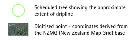
The diagrams show a green ellipse or circle (or several
ellipses or circles) around the scheduled tree. The polygon (or polygons)
form the definitive location of the scheduled tree.
Some diagrams may include parts of a tree extending
below mean high water springs (MHWS). Areas below MHWS fall within the
jurisdiction of the Auckland Regional Council, and are therefore outside
the jurisdiction of this Plan. Any areas below MHWS are indicative and
shown for information purposes only.
4.0 Diagrams of scheduled trees
Diagrams legend
5.0 Scheduled
trees on Motuihe and Motutapu
This table lists trees which were scheduled in the previous
district plan and which have been carried over without further detailed
evaluation. The locations of the trees are also identified on the planning
maps. Part 7 - Heritage contains the objectives, policies and rules
that apply to scheduled trees.
| Planning
map ref |
Common
name |
Scientific
name |
Location |
Category
1 |
| 31-6 |
Olive grove |
Olea europaea |
Motuihe |
B |
| 31-7 |
Norfolk pines (2), Moreton Bay
fig |
Araucaria heterophylla, Ficus
macrophylla |
Home Bay, Motutapu |
B |
| 31-8 |
Norfolk pines (12), Plane trees
(2) |
Araucaria heterophylla, Platanus
acerifolia |
Emu Bay, Motutapu |
B |
Note:
- A category B status has been allocated
to all these trees.