District Plan Hauraki Gulf Islands Section - Proposed 2006
(Notified version 2006)
Street index |
Planning maps |
Text |
Appendices |
Annexures |
Section 32 material |
Plan modifications |
Help |
Notified - Home |
Decision - Home
Hearing reports index
Report on submissions to the Auckland City District Plan: Hauraki Gulf Islands
Section - Proposed 2006
| Topic: |
Part 12 - Subdivision |
| Report to: |
The Hearing Panel |
| Author: |
Kym Lewis |
| Date: |
13 June 2008 |
| Group file: |
314/274030 |
1.0 Introduction
This report considers submissions and further submissions ('submissions') that
were received by the council in relation to the subdivision provisions of the Auckland
City District Plan: Hauraki Gulf Islands Section - Proposed 2006 ('the Plan'). The
Plan was publicly notified on 18 September 2006. The closing date for lodging submissions
was 11 December 2006. The submissions were publicly notified for further submission
on 29 April 2007. The closing date for lodging further submissions was 28 May 2007.
This report has been prepared under section 42A of the Resource Management Act
1991 ('the RMA'), to assist the hearings panel to consider the submissions on subdivision.
This report discusses the submissions (grouped by subject matter or individually)
and includes recommendations from the planner who prepared this report. The recommendations
identify whether each submission should be accepted or rejected (in full or in part)
and what amendments (if any) should be made to the Plan to address matters raised
in submissions. Further submissions are dealt with in conjunction with the submissions
to which they relate.
The recommendations contained in this report are not decisions of the council.
The council will issue its decisions following consideration of the submissions,
further submissions, any supporting evidence presented at the hearing, and this
report. The council's decisions will be released after all the hearings to the Plan
have been completed.
2.0 Statutory framework
This section of the report briefly sets out the statutory framework within which
the council must consider the submissions. In preparing this report the submissions
and, in particular, the decisions requested in the submissions, have been considered
in light of the relevant statutory matters. These were summarised by the Environment
Court in Eldamos Investments Limited v Gisborne District Council W
047/05
where the court set out the following measures for evaluating objectives, policies,
rules and other methods in district plans:
- The objectives of the Plan are to be evaluated by the extent to which they:
- Are the most appropriate way to achieve the purpose of the RMA (s32(3)(a));
and
- Assist the council to carry out its functions in order to achieve the purpose
of the RMA (s72); and
- Are in accordance with the provisions of part 2 of the RMA (s74(1).
- The policies, rules, or other methods in the Plan are to be evaluated by the
extent to which they:
- Are the most appropriate way to achieve the objectives of the Plan (s32(3)(b));
and
- Assist the council to carry out its functions in order to achieve the purpose
of the RMA (s72); and
- Are in accordance with the provisions of part 2 of the RMA (s74(1)); and
- (If a rule) achieve the objectives and policies of the Plan (s76(1)(b)).
The purpose of the RMA is "to promote the sustainable management of natural and
physical resources", and "sustainable management" is defined in section 5(2) as
meaning:
"... managing the use, development, and protection of natural and physical resources
in a way, or at a rate, which enables people and communities to provide for their
social, economic, and cultural wellbeing and for their health and safety while�
(a) Sustaining the potential of natural and physical resources (excluding minerals)
to meet the reasonably foreseeable needs of future generations; and
(b) Safeguarding the life-supporting capacity of air, water, soil, and ecosystems;
and
(c) Avoiding, remedying, or mitigating any adverse effects of activities on the
environment."
Along with section 5, part 2 of the RMA includes sections 6 (matters of national
importance), 7 (other matters) and 8 (Treaty of Waitangi), which set out a range
of matters that the council needs to recognise and provide for in achieving the
purpose of the RMA. Those matters are also relevant when considering submissions.
The Plan must assist the council to carry out its functions under section 31
of the RMA. These functions are:
"(a) The establishment, implementation, and review of objectives, policies, and
methods to achieve integrated management of the effects of the use, development,
or protection of land and associated natural and physical resources of the district:
(b) the control of any actual or potential effects of the use, development, or
protection of land, including for the purpose of�
(i) the avoidance or mitigation of natural hazards; and
(ii) the prevention or mitigation of any adverse effects of the storage, use,
disposal, or transportation of hazardous substances; and
(iia) the prevention or mitigation of any adverse effects of the development,
subdivision, or use of contaminated land:
(iii) the maintenance of indigenous biological diversity:
(c) ...
(d) The control of the emission of noise and the mitigation of the effects of
noise:
(e) The control of any actual or potential effects of activities in relation
to the surface of water in rivers and lakes."
In addition to the matters listed above from the Eldamos decision:
- The Plan must "give effect to" any national policy statement and any New Zealand
coastal policy statement (s75(3)(a) and (b)).
- The Plan must be "give effect to" the regional policy statement (made operative
after 10 August 2005) (s75(3)(c)).
- The Plan must be "not inconsistent with" any regional plan (s75(4)).
- The council must ensure that that the Plan does not conflict with sections
7 and 8 of the Hauraki Gulf Marine Park Act 2000 ("the HGMPA"). Section
10 of the HGMPA requires that sections 7 and 8 of that Act be treated as a New
Zealand coastal policy statement under the RMA.
3.0 Background
This section of the report sets out background information about the topic under
consideration. It identifies how the Plan deals with subdivision.
In accordance with section 218 of the RMA, subdivision includes freehold subdivision
and lease hold subdivision. This includes the creation of fee simple sites, unit
titles, company lease or company titles and cross leases. Subdivision is therefore
the process of dividing a parcel of land or a building into one or more parcels,
or changing an existing boundary location.
The subdivision of land may not directly create adverse effects on the environment.
However it does provide opportunities and expectations for future development which
may cause adverse effects.
The physical and natural environment in the islands creates major constraints
on subdivision. In particular, there is a need to preserve the natural environment,
visual character, amenity, and heritage values and to have regard to drainage capability.
The Plan also recognises the potential for adverse effects arising from subdivision
within and associated with the coastal environment. The Plan's objectives, policies
and rules give particular emphasis to ensuring a proper assessment of such effects
when subdivision applications are evaluated.
This section of the Plan recognises the relationship between subdivision and
the effects on landscape character from associated land use activities by establishing:
- Minimum area standards for sites.
- Assessment criteria for considering subdivision proposals. This includes criteria
relating to site design and layout, utility services, access to the site(s), public
access to open spaces, coasts, rivers and lakes as well as criteria relating to
the protection and enhancement of the natural environment.
4.0 Analysis of submissions
4.1 Introduction
This section of the report discusses the decisions requested in submissions about
subdivision and recommends how the panel could respond to the matters raised and
decisions requested in submissions. The submissions are addressed under subject
headings. While the relevant statutory matters (identified in section 2 of this
report) will not necessarily be referred to directly, the discussion and recommendations
have given appropriate consideration to these and any other relevant matters.
A list of the submissions which raise issues about subdivision together with
the related further submissions is contained in Appendix 1. Appendix 2
contains copies of the submissions and further submissions. Any amendments to the
Plan recommended in response to submissions are identified in this section of the
report and are further detailed in Appendix 3.
The list of submissions contained in Appendix 1 may include some submissions
and further submissions which were received 'late', ie they were received after
the closing date for lodging submissions (11 December 2006) or further submissions
(28 May 2007). All late submissions were considered by the hearing panel at the
start of the hearing process and the panel has already waived the failure to comply
with the time limit for any late submissions or further submissions listed in
Appendix 1. This has been done in accordance with sections 37 and 37A of the
RMA.
4.2 Submissions about rejecting all of part 12.
Submissions dealt with in this section:
2803/1,
2812/1,
2815/1,
2818/1,
2822/1,
2808/1
4.2.1 Decision requested
The above submissions request the following:
To reject the proposed provisions (for part 12) in their entirety and seek
effects based solutions from the workshops that were put forward by the community.
4.2.2 Planner's analysis
The submissions do not specifically identify any changes needed so that effects
based solutions from the workshops are encouraged and facilitated. Accordingly,
the above submitters are invited to provide clarification at the hearing as to how
Part 12 should be amended in order to achieve effects based solutions from the workshops.
Notwithstanding the above, the following comments are made with regard to the
above submissions:
The above submissions raise matters which are the subject of other hearings reports
particularly, the hearing report pertaining to the "Whole Plan". This report addresses
matters relating to the RMA 1991, the section 32 analyses and the prescriptive nature
of the Plan.
A meeting was held in September 2005 to select members of the Waiheke community
and local experts to attend a series of 3 focus group meetings on 4 topics as part
of the review of the HGI plan. The intent of these meetings was to allow members
of the focus groups to provide further input into how the district plan should deal
with the following broad issues.
Each of the four focus groups held on Waiheke developed a set of directions for
the working party. Those directions are publicly available and are on council's
website. Some focus groups did not reach agreement on all of their directions. The
directions were reported to the working party and were one of a range of inputs
taken into account in developing the Plan. As is appropriate, the Plan concentrates
on objectives, policies and rules and does not include details about how the consultation
process (including the focus groups) influenced the content of the Plan.
With regard to subdivision, the following directions were agreed upon by the
focus groups:
- Get mechanisms / management right for access provisions e.g. esplanade strips,
walkways, etcetera
- Subdivision should provide for public access / opening up of uniform legal
roads, etcetera;
- Work is needed on how the plan could provide for affordable housing (issue
is community diversity) - will need very careful consideration - work should examine
how the plan allows for co-housing, multi units, etcetera, also link with visitor
facilities.
The following directions given to the working party that were not fully agreed
on by the focus groups were:
- Allow for the provision of 'granny' flats - 1 per site;
- Maintain existing densities within the Plan;
- Allow for bonus provisions i.e. additional height, density, etcetera for comprehensive
developments i.e. innovative housing, eco housing which support sustainability
principles
- Allow for 1-step or conjoint process for subdivision and landuse;
- Plan for growth by providing higher density pocket in existing urban areas
and provide for flexibility in rural areas e.g. cluster development which maintains
values and environmental improvements we want to achieve.
As noted in sections 4.15 and 4.20 of this report, part 12 provides for the public
access in the form of financial contributions, esplanade reserves and/or esplanade
strips. The provision for bonus density subdivision is also considered in section
4.22 of this report and enabling growth within the Hauraki Gulf Islands is assessed
within hearings report for Part 2 � Resource management overview and Appendix 10
(HGMPA).
In addition, a 1-step process for subdivision and land use development is provided
by way of clauses 12.6.1(1) and (2) whereby the opportunity to combined the both
land use activities at the time of subdivision can be achieved by applying for a
joint land use/subdivision consent.
4.2.3 Planner's recommendation
The submissions being considered in this section of the report are too general
to be the basis of any recommended changes to the Plan. However it is considered
that, the directions provided at the focus groups as they relate to subdivision
have been considered and where appropriate, included as part of the objectives,
polices and rules for part 12 (subdivision).
It should also be noted that, there are a large number of other submissions and
other subparts to the above submissions that raise more specific concerns about
the implications of the Plan. These will be considered in other hearing reports
and the council may make some amendments in response.
On this basis, it is recommended that submissions
2803/1,
2812/1,
2815/1,
2818/1,
2822/1,
2808/1 are
rejected.
4.3 Submission about preventing subdivision due to infrastructure constraints.
Submission dealt with in this section:
2995/7
4.3.1 Decision requested
The above submission seeks the following:
No more subdivisions for developers as the infrastructure won't handle it.
4.3.2 Planner's analysis and recommendation
It is recognised that past subdivision rules particularly within the island residential
1 and 2 land units have resulted in small site sizes that were appropriate to a
village scale. However, this historic pattern of subdivision did not relate to specific
natural characteristics of the land and the need to accommodate on-site effluent
disposal systems. Accordingly, infrastructure constraints have resulted within these
areas particularly in terms of providing for onsite wastewater and stormwater disposal.
On this basis, it is considered that historical subdivision patterns on the islands
(and on Waiheke, Rakino and Great Barrier in particular), are not necessarily consistent
with the objectives of securing appropriate management of resources, or consistent
with achieving sustainable land use development. The policies also emphasis that
open character is the desired pattern, irrespective of existing site sizes and landscape
patterns that were created in the past.
Therefore, the policies and ensuing rules with the Plan, particularly for these
residential land units and the settlement areas, now seek to provide for subdivision
that provides for and enhances the character of these areas, and ensures that development
resulting from subdivision can adequately dispose of stormwater and onsite wastewater
without adversely affecting the natural environment. Further consideration is given
to ensuring that the safety of people and property from natural hazards and contaminated
land are avoided, remedied or mitigated, and that each proposed site provides for
utility services.
On this basis, it is considered that the objectives, policies and rules within
the Plan provide a greater level of assessment in terms of a site's capacity to
accommodate infrastructure. This is achieved through appropriate minimum site areas
for land units and settlement areas as well as amended objectives, policies and
assessment criteria which consider how sites can be adequately serviced.
For reasons outlined above, it is recommended that the above submission be rejected.
| Planner's recommendations about preventing subdivision due
to infrastructure constraints.
That submission
2995/7
be rejected.
|
4.4 Submission about a full review of subdivision as it relates to Great Barrier
Island
Submission dealt with in this section:
3110/1
4.4.1 Decision requested
The above submission seeks the following:
Totally review the subdivision section of the plan especially the areas suitable
of subdivision on Great Barrier.
4.4.2 Planner's analysis and recommendation
The above submission seeks a "total reassessment" of the minimum site sizes and
the settlement areas to better reflect "the future potential of development on Great
Barrier Island". The submitter considers that there are a number of areas more appropriate
for sustainable subdivision throughout Great Barrier Island.
It is considered that submission 3110 is too general to be the basis of any recommended
changes to part 12 of the Plan. Indeed, the above submission makes various general
statements of an ideological nature without specifically identify any changes needed
so that part 12 can better reflect the "future potential of development on Barrier".
Accordingly, submitter 3110 is invited to provide clarification at the hearing as
to how Part 12 should be amended in order to reflect the future potential of development
on Great Barrier Island.
It should be noted that the extent of the settlements areas is being reviewed
and the intention is to consolidate and provide for development in those areas.
For reasons set out above, it is recommended that submission
3110/1
be rejected as it makes a various general statement of an ideological nature without
seeking any specific decision.
| Planner's recommendations about a full review of subdivision
as it relates to Great Barrier Island.
That submission
3110/1
be rejected.
|
4.5 Submissions about 'wastewater references'
Submissions dealt with in this section:
308/6,
371/6,
573/6,
630/6,
641/6,
647/6,
656/6,
674/6,
686/6,
697/6,
699/6,
711/6,
719/6,
726/6,
740/6,
798/6,
807/6,
812/6,
815/6,
824/6,
1828/6,
873/6,
885/6,
910/6,
932/6,
959/6,
1015/6,
1055/51,
1236/6,
1814/6,
1815/6,
1816/6,
1817/6,
1818/6,
1819/6,
1820/6,
1821/6,
1822/6,
1823/6,
1825/6,
1826/6,
1827/6,
1829/6,
1830/6,
1831/6,
1832/6,
1833/6,
1834/6,
1835/6,
1836/6, 2285/6,
2462/6,
2704/6,
2794/6,
2833/6,
2995/6,
3005/6,
3190/6,
3209/6,
3218/6,
3228/6,
3236/6,
3253/6,
3267/6,
3278/6,
3289/6,
3305/6,
3314/6,
3318/6,
3336/6,
3340/6,
3356/6,
3366/6,
3371/6,
3386/6,
3404/6,
3559/6,
3624/6,
3646/6,
3823/6,
726/7.
4.5.1 Decisions requested
Submission
726/7
requests the following:
That composting toilets and greywater systems be the preferred option for
all subdivisions.
Submissions
308/6,
371/6,
573/6,
630/6,
641/6,
647/6,
656/6,
674/6,
686/6,
697/6,
699/6,
711/6,
719/6,
726/6,
740/6,
798/6,
807/6,
812/6,
815/6,
824/6,
1828/6,
873/6,
885/6,
910/6,
932/6,
959/6,
1015/6,
1055/51,
1236/6,
1814/6,
1815/6,
1816/6,
1817/6,
1818/6,
1819/6,
1820/6,
1821/6,
1822/6,
1823/6,
1825/6,
1826/6,
1827/6,
1829/6,
1830/6,
1831/6,
1832/6,
1833/6,
1834/6,
1835/6,
1836/6, 2285/6,
2462/6,
2704/6,
2794/6,
2833/6,
2995/6,
3005/6,
3190/6,
3209/6,
3218/6,
3228/6,
3236/6,
3253/6,
3267/6,
3278/6,
3289/6,
3305/6,
3314/6,
3318/6,
3336/6,
3340/6,
3356/6,
3366/6,
3371/6,
3386/6,
3404/6,
3559/6,
3624/6,
3646/6,
3823/6 request
the following:
That the 'wastewater' references in clauses 12.2, 12.4, 12.6, 12.9, 12.11,
12.12, be differentiated as appropriate (to include greywater, blackwater with /
without solids, and septic tank processed blackwater adequate / inadequate to pump
without additional water, septic tank sludge);
4.5.2 Planner's analysis and recommendations
Subdivision should only occur on land where there is adequate physical capacity
and capability to accommodate development impacts. Wastewater references are therefore
included within the above clauses to ensure that sites have the capacity to accommodate
wastewater generated from land use developments. Meeting such a requirement requires
assessment from a suitably qualified person who will look at the soil type and land
area to determine if the land has the ability to accommodate on-site wastewater.
More specific wastewater designs are often undertaken at the time of development
(i.e. land use stage).
The above submissions seek to reference various types of wastewater systems and
to further define wastewater disposal within Part 12 of the Plan. While compositing
toilets and greywater systems are utilised throughout the Hauraki Gulf Islands,
wastewater in the islands is currently disposed of through a wide range of on-site
disposal systems, consisting in the main of septic tank pre-treatment units and
effluent soakage fields.
In response to the above submissions, it is the Auckland Regional Council (ARC),
rather than the city council, which has functions under the RMA (s30) relating to
the quality, quantity, level, flow, taking or use, of water. Specifically, wastewater
is assessed in accordance with the ARC document, Technical Publication 58 - On-site
wastewater systems: design and management manual (TP58). The Building Act 2004 and
the council's bylaw also controls wastewater disposal.
These publications specifically identify how wastewater should be disposed of
(including composting toilets and grey water systems) and differentiates between
grey water and black water and the specific treatment of solids.
It is further noted that TP58 is already in its third edition (2004) and is updated
when better design guidelines are devised by engineers. Accordingly, a wastewater
design or treatment process specified within a district plan may eventually be superseded
by more efficient design guidelines in the future. This would result in conflicting
legislation (district plan and TP58) and confusion over how on-site wastewater should
be assessed.
Therefore, as the Council's bylaw, the Building Act and the ARC already place
controls on the disposal of wastewater, it is not considered necessary to duplicate
these controls or include additional controls in the Plan. Any amendments to wastewater
disposal should be made in accordance with these documents rather than within the
Plan.
For these reasons, it is recommended that the above submissions be rejected.
| Planner's recommendations about submissions seeking additional
wastewater references
That submissions
308/6,
371/6,
573/6,
630/6,
641/6,
647/6,
656/6,
674/6,
686/6,
697/6,
699/6,
711/6,
719/6,
726/6,
740/6,
798/6,
807/6,
812/6,
815/6,
824/6,
1828/6,
873/6,
885/6,
910/6,
932/6,
959/6,
1015/6,
1055/51,
1236/6,
1814/6,
1815/6,
1816/6,
1817/6,
1818/6,
1819/6,
1820/6,
1821/6,
1822/6,
1823/6,
1825/6,
1826/6,
1827/6,
1829/6,
1830/6,
1831/6,
1832/6,
1833/6,
1834/6,
1835/6,
1836/6,
2285/6,
2462/6,
2704/6,
2794/6,
2833/6,
2995/6,
3005/6,
3190/6,
3209/6,
3218/6,
3228/6,
3236/6,
3253/6,
3267/6,
3278/6,
3289/6,
3305/6,
3314/6,
3318/6,
3336/6,
3340/6,
3356/6,
3366/6,
3371/6,
3386/6,
3404/6,
3559/6,
3624/6,
3646/6,
3823/6,
726/7
be rejected.
|
4.6 Submissions about a sustainable development in landforms 5 and 6.
Submissions dealt with in this section:
284/4,
2598/5,
1284/5.
4.6.1 Decisions requested
The above submissions request:
The proposed provisions for landform 5 (productive land) and 6 (regenerating
slopes) in relation to subdivision activities should be amended so that a more proactive
approach to sustainable development is encouraged and facilitated.
4.6.2 Planner's analysis and recommendations
The submissions being considered in this section of the report are too general
to be the basis of any recommended changes to the Plan and do not specifically identify
any changes needed to landforms 5 and 6 within Part 12 so that a more proactive
approach to sustainable development is encouraged and facilitated. Accordingly,
the submitters are invited to provide clarification at the hearing.
Notwithstanding this, the objectives, policies and rules in the Plan as they
relate to landforms 5 and 6 have been written with the intention of achieving the
purpose of the Act. The purpose of the RMA is 'to promote the sustainable management
of natural and physical resources'. Sustainable management is defined in s5(2) and
is also set out in section 2.0 of this document. The council is required to take
the purpose of the Act into account when considering alternatives, benefits and
costs under s32.
Throughout the hearing process the council will consider submissions which seek
that specific rules be eliminated or relaxed. Indeed, these submitters have lodged
other submissions which will be considered in other hearing reports and in the following
sections of this report. Accordingly, the council may make some amendments in response.
Therefore, given that submissions
284/4,
2598/5,
1284/5
do not specifically identify any changes needed so that a more proactive approach
to sustainable development is encouraged and facilitated, it is recommended that
these submissions be rejected.
| Planner's recommendations about submissions seeking a more
proactive approach to sustainable development in landform 5 (productive land)
and landform 6 (regenerating slopes). |
That submissions
284/4,
2598/5,
1284/5
be rejected.
4.7 Submissions about landscape and coastal and rural amenity protection, including
the Hauraki Gulf Island Marine Park Act 2000.
Submissions dealt with in this section: Group 1
308/1,
371/1,
573/1,
630/1,
641/1,
647/1,
656/1,
674/1,
686/1,
697/1,
699/1,
711/1,
719/1,
726/1,
740/1,
798/1,
807/1,
812/1,
815/1,
824/1,
873/1,
885/1,
910/1,
932/1,
959/1,
960/1,
1015/1,
1055/46,
1133/1,
1236/1,
1814/1,
1815/1,
1816/1,
1817/1,
1818/1,
1819/1,
1820/1,
1821/1,
1822/1,
1823/1,
1825/1,
1826/1,
1827/1,
1828/1,
1829/1,
1830/1,
1831/1,
1832/1,
1833/1,
1834/1,
1835/1,
1836/1, 2285/1,
2462/1,
2704/1,
2794/1,
2833/1,
2995/1,
3005/1,
3190/1,
3209/1,
3218/1,
3228/1,
3236/1,
3253/1,
3267/1,
3278/1,
3289/1,
3305/1,
3314/1,
3318/1,
3336/1,
3340/1,
3356/1,
3366/1,
3371/1,
3386/1,
3404/1,
3559/1,
3624/1,
3646/1,
3823/1;
and
Group 2
308/2,
371/2,
573/2,
630/2,
641/2,
647/2,
656/2,
674/2,
686/2,
697/2,
699/2,
711/2,
719/2,
726/2,
740/2,
798/2,
807/2,
812/2,
815/2, ,
824/2,
873/2,
885/2,
910/2,
932/2,
959/2,
960/2,
1015/2,
1055/47,
1133/2,
1236/2,
1814/2,
1815/2,
1816/2,
1817/2,
1818/2,
1819/2,
1820/2,
1821/2,
1822/2,
1823/2,
1825/2,
1826/2,
1827/2,
1828/2,
1829/2,
1830/2,
1831/2,
1832/2,
1833/2,
1834/2,
1835/2,
1836/2, 2285/2,
2462/2,
2704/2,
2794/2,
2833/2,
2995/2,
3218/2,
3253/2,
3305/2,
3005/2,
3190/2,
3209/2,
3228/2,
3236/2,
3267/2,
3278/2,
3289/2,
3314/2,
3318/2,
3336/2,
3340/2,
3356/2,
3366/2,
3371/2,
3386/2,
3404/2,
3559/2,
3624/2,
3646/2,
3823/2,
3700/1.
4.7.1 Decision requested
Group 1 submissions request the following:
The introduction of better focused landscape and coastal and rural amenity
protection within part 12, including specific reference to the HGMPA within the
issues, objectives, policies and rules of part 12;
Group 2 submissions request the following:
The specific referencing within Part 12 to coastal amenity area protection
and enhancement.
Submission
3700/1
requests the following:
The protection and enhancement, of landscape and view shafts (relative to
vantage points at sea and on the land) and coastal and rural amenity, must be given
effect to within Part 12 of the Plan. This must include specific reference to the
HGMP Act in all sections to do with Resource Management Issues, Objectives, Policies
and Rules.
4.7.2 Planner's analysis and recommendation
4.7.2.1 Landscape, coastal and rural amenity protection
The above submissions do not specifically identify any changes needed in order
to better focus on landscape, coastal and rural amenity protection. Accordingly,
the above submitters are invited to provide clarification at the hearing as to how
Part 12 should be amended in order to better focus on landscape, coastal and rural
amenity protection.
Notwithstanding this, the following comments are made with respect to these matters:
Coastal protection
The Plan provisions recognise the potential for adverse effects that may arise
from subdivision within and associated with the coastal environment. The objectives
within Part 12 of the plan seek to control subdivision so as to preserve the natural
character, landscape values, heritage and amenity values of the coastal environment.
This is highlighted within objective 12.3.1 � natural character and landscape
values and by the associated policies (3) and (4) which state:
(3) By avoiding subdivision and development in the coastal environment where
it would result in sprawling or sporadic development.
(4) By limiting subdivision and associated development in areas with outstanding
landscape value within the coastal environment so that natural character and landscape
values are not adversely affected.
The subdivision provisions in each land unit seek to give effect to the objectives
and policies by enabling an appropriate pattern and density of development. Buildings
in sensitive land units are also controlled by the Plan. Such an approach within
both the land use and subdivision provisions is considered consistent with coastal
protection.
Coastal Amenity Areas
The Plan identifies some beach front locations within island residential 1 (traditional
residential) as being subject to an additional limitation described as 'coastal
amenity area'. This limitation applies to the beach front land at Oneroa, Palm Beach,
Blackpool and Onetangi on Waiheke Island. Within island residential 1, additional
controls are placed on buildings in the coastal amenity area so that they do not
compromise the character and amenity of the coast. Within the coastal amenity area,
a land use consent for a restricted discretionary activity is required for buildings,
including relocations, alterations and/or additions. Elsewhere within the land unit,
such building work when associated with a permitted activity (such as a dwelling),
does not require a land use consent.
On Great Barrier Island, there are sub-areas within certain settlement areas
which are identified as 'Reserve, dune, coastal margin and wetland conservation
areas'. Like the provision for islands residential above, a resource consent for
a restricted discretionary activity is required for buildings, including relocations,
alterations and/or additions. In addition, table 12.3 states that subdivision in
'Reserve, dune, coastal margin and wetland conservation areas' is a non-complying
activity.
Additional coastal protection is addressed in a wide variety of other ways in
the Plan such as:
- by classifying some land in coastal locations as landform 1 (coastal cliffs
and slopes) and landform 2 (dune systems and sand flats)
- by classifying esplanade reserves as recreation 1 (local parks and esplanade
reserves)
- by requiring (in clause 10c.5.7) coastal protection yards in all land units
and settlement areas where development or activities are provided for
- by identifying scheduled items in coastal locations eg ecologically significant
sites, archaeological sites
- by identifying some natural hazards in coastal locations ie the erosion risk
zones at Onetangi Beach, and Kennedy Point
- by including rules and guidelines on esplanade reserves in part 12 - Subdivision.
Other submissions seek additional decisions related to coastal amenity areas
including the extension of this control to all beach front locations. Those matters
will be considered in other hearing reports.
It is not clear exactly what amendments the above submissions are seeking when
they ask for ' better focused landscape and coastal and rural amenity protection'
. However, the coastal amenity areas are given priority in the Plan by imposing
additional controls on development within landform 1, parts of island residential
1 and within specific sub-areas of the settlement areas.
Landscape and rural amenity protection
In determining whether the proposed policies, rules or other methods are the
most appropriate for achieving the objectives, the review of the subdivision provisions
was undertaken after detailed landscape analysis by John Hudson, a registered landscape
architect. Minimum site size for each land unit, including the more rural land units
(Landforms 1-7, Rural 1-3) are therefore set at a level that is consistent with
the objectives and policies for the land units, which seek to maintain elements,
features and patterns that contribute to the visual amenity, natural landscape character
and amenity value of each land unit.
The proposed rules also seek to protect and enhance the natural environment including
indigenous vegetation, wetlands, ridgelines, headlands, heritage features and outstanding
landscape features. Accordingly, clauses 12.9.3 (protection of significant environmental
feature(s)) and 12.9.4 (Cluster subdivision associated with the protection of significant
environmental features) provide for a reduction to the minimum site sizes within
landform 2-7 and rural 1 only, provided there is a significant environmental feature
worthy of protection. The reduced site sites are contained in table 12.2 and the
definition of a significant environmental feature is contained in Part 14 (definitions).
In light of the above, the panel can be satisfied that the objectives, policies
and rules in Part 12 of the Plan have been written with the intention of achieving
the purpose of the RMA. This includes protecting and enhancing the coast as well
as the landscape and rural amenity.
4.7.2.2 Hauraki Gulf Marine Park Act (HGMPA)
The council must ensure that that the Plan does not conflict with sections 7
and 8 of the HGMPA. Section 10 of the HGMPA requires that sections 7 and 8 of that
Act be treated as a New Zealand coastal policy statement under the RMA. The Plan
must 'give effect to' any New Zealand coastal policy statement.
While specific reference to the HGMPA has not been made within Part 12 of the
Plan, the Plan itself does appropriately recognise the role of the HGMPA. The HGMPA
is addressed in the following places within the Plan:
- clause 1.3.6
- clause 2.3.2
- clause 2.5 (at clause 2.5.3, issue (3); clause 2.5.8, objective (2))
- clause 11.2(1)
- appendix 10 - which contains s7, 8 and 9 of the HGMPA.
In addition, the HGMPA was considered by the council in the section 32 reports
prepared.
Notwithstanding this, it is considered that the objectives, policies and rules
within Part 12 give effect to sections 7 and 8 of the HGMPA for the following reasons:
The objectives, policies and rules provide for subdivision based upon the physical
characteristics of the land and its capacity to integrate development impacts as
well as consideration of natural character, visual character and amenity values.
By recognising the physical capacity and capability of land to accommodate development
impacts, this will enable the protection of the natural and physical resources,
historic, traditional, cultural, and spiritual relationship of the tangata whenua
of the Gulf and its islands. The objectives, policies and rules will also enable
the protection of the life supporting capacity of soil air, water and ecosystems,
whilst also allowing people and communities of the Gulf to provide for their social
and economic wellbeing and their health and safety.
Accordingly, it is not considered necessary to specifically reference the HGMPA
within Part 12 when the objectives, policies and rules of the Plan already combine
to give effect to sections 7 and 8 of the HGMPA.
Notwithstanding the above, it should be noted that, throughout the hearing process
the council will consider submissions which seek that specific rules be eliminated
or relaxed. Indeed, many of the above submitters (groups 1 and 2) have lodged submissions
which will be considered in other hearing reports, and the council may make some
amendments in response. In the event amendments are made with regard to HGMPA, consequential
amendments to Part 12 may be considered necessary and will be addressed accordingly.
For these reasons outlined above, it is recommended that the decision sort with
respect to the above submissions be rejected.
4.7.2.3 View Shafts
With regard to the protection and enhancement of view shafts, it is unclear as
to which views are of particular concern. Like the operative Plan, the proposed
Plan does not seek to specifically protect any public views. Protection of public
views was a matter that was raised in consultation and by the Waiheke focus group
that considered landscape matters. The council's landscape consultant, John Hudson,
undertook some preliminary assessment of ten public views on Waiheke. That assessment
is summarised in a document entitled Waiheke Island View Report [1] which
is available on Council's website. The report identifies that in order to retain
some of the views considered, it may be necessary to control the potential development
or vegetation that could occur on adjacent private properties. The report also identified
that, in some cases, management of vegetation on adjacent council owned land such
as road berms or reserves would be required to retain views.
The council did not include any controls in the Plan specifically aimed at protecting
public views because it did not have sufficient information to formulate an effective
control or justify its introduction. Any view shafts would need to be defined by
survey so that the permitted heights of trees and buildings could be accurately
identified. The implications of these limitations for private property would need
to be carefully considered. Furthermore, the Plan generally seeks to promote planting
and retention of vegetation, and has extended the vegetation controls on Waiheke
to also apply to exotic trees. To then limit the height or planting of vegetation
in some locations, would create some potential conflicts within the Plan.
It is noted that proposed change 8 (landscape and volcanic cones) to the ARC's
Regional Policy Statement identifies some views to volcanic cones as being of regional
significance. This includes views from the Auckland isthmus to Browns Island and
Rangitoto. Change 8 does not identify any other views within the Hauraki Gulf islands
as being of regional significance.
For reasons set out above, it is recommended that the above submissions be rejected
as it relates to protection and enhancement of landscapes and view shafts.
Planner's recommendations about submissions seeking better
focused landscape and coastal and rural amenity protection within part 12 of
the Plan, including specific reference to the HGMPA.
- That group 1submissions
308/1,
371/1,
573/1,
630/1,
641/1,
647/1,
656/1,
674/1,
686/1,
697/1,
699/1,
711/1,
719/1,
726/1,
740/1,
798/1,
807/1,
812/1,
815/1,
824/1,
873/1,
885/1,
910/1,
932/1,
959/1,
960/1,
1015/1,
1055/46,
1133/1,
1236/1,
1814/1,
1815/1,
1816/1,
1817/1,
1818/1,
1819/1,
1820/1,
1821/1,
1822/1,
1823/1,
1825/1,
1826/1,
1827/1,
1828/1,
1829/1,
1830/1,
1831/1,
1832/1,
1833/1,
1834/1,
1835/1,
1836/1,
2285/1,
2462/1,
2704/1,
2794/1,
2833/1,
2995/1,
3005/1,
3190/1,
3209/1,
3218/1,
3228/1,
3236/1,
3253/1,
3267/1,
3278/1,
3289/1,
3305/1,
3314/1,
3318/1,
3336/1,
3340/1,
3356/1,
3366/1,
3371/1,
3386/1,
3404/1,
3559/1,
3624/1,
3646/1,
3823/1
be rejected; and
- Group 2 submissions
308/2,
371/2,
573/2,
630/2,
641/2,
647/2,
656/2,
674/2,
686/2,
697/2,
699/2,
711/2,
719/2,
726/2,
740/2,
798/2,
807/2,
812/2,
815/2,
, 824/2,
873/2,
885/2,
910/2,
932/2,
959/2,
960/2,
1015/2,
1055/47,
1133/2,
1236/2,
1814/2,
1815/2,
1816/2,
1817/2,
1818/2,
1819/2,
1820/2,
1821/2,
1822/2,
1823/2,
1825/2,
1826/2,
1827/2,
1828/2,
1829/2,
1830/2,
1831/2,
1832/2,
1833/2,
1834/2,
1835/2,
1836/2,
2285/2,
2462/2,
2704/2,
2794/2,
2833/2,
2995/2,
3218/2,
3253/2,
3305/2,
3005/2,
3190/2,
3209/2,
3228/2,
3236/2,
3267/2,
3278/2,
3289/2,
3314/2,
3318/2,
3336/2,
3340/2,
3356/2,
3366/2,
3371/2,
3386/2,
3404/2,
3559/2,
3624/2,
3646/2,
3823/2,
3700/1
be rejected.
|
4.8 Submissions about under grounding of services at subdivision.
Submissions dealt with in this section:
526/14,
527/14,
528/14,
529/14,
539/14
4.8.1 Decision requested
The above submissions request:
Amend any existing sections of the Plan that refer to the under grounding
of electricity and telecommunication services in landforms which are not urban being
a requirement at the time of subdivision. These sections should be amended to encourage
placing services underground and that each rural subdivision application will be
assessed on what is appropriate for that particular site and proposal.
4.8.2 Planner's Analysis and recommendation
In responding to the above submissions, it is considered necessary to turn to
the current wording of objective 12.3.8 and its associated policies:
Objective 12.3.8
To design subdivisions so that network utility services are installed in a
manner that minimises any adverse effects on the environment, including visual amenity,
noise, earthworks, dust, spill lighting, electro magnetic field emissions and radio
frequency fields (RF).
Policies
- By requiring at the time of subdivision that electricity and telecommunication
services are placed underground.
- By preventing the installation of utility services which may be sought
in conjunction with subdivision where the effect on landscape and amenity values
cannot be adequately remedied or mitigated.
The proposed policies relate to clause 12.6.1 (bulk, location and access controls
for buildings) whereby each site must demonstrate where a building, access and parking
can be constructed which complies with specific development controls, including
part 5 (Network utilities).
The Plan recognises the relationship between subdivision and the effect on landscape
character from associated land use activities. Particularly in the inner islands,
electricity and telecommunication services are invariably required to service any
activity on a site. Such services can take the form of tall power/telecommunication
poles with overhead cabling, which can adversely affect the landscape character
and amenity value of an area. Applicants will therefore need to consider the provision
of utility services as an integral part of any subdivision.
The polices and assessment criteria in clause 12.11.11 (Network utility services)
consider the design of subdivision within all land units and settlement areas and
how each can be serviced by network utilities without adversely affecting the natural
landscape and amenity qualities of the environment. Matters to consider include
shared services (easements) and the extent to which services can be placed underground.
Criterion 12.11.11(4) also considers whether the provision of network utility
services are appropriate given the potential uses and particular characteristics
of an area. For example, rural sites may not be able to connect to network utility
services due to an absence of these services in the area or because providing such
services may adversely affect the landscape character of the area. As such, alternative
measures can be considered such as generators. Consideration of these matters will
enable sites that are capable of accommodating additional land use development,
to be subdivided without having to modify the landscape.
It is considered that objective 12.3.8, the associated policies and assessment
criteria seek to design subdivision so that network utility services are installed
in a manner that minimises any adverse effects on the environment. This includes
the under grounding of electricity and telecommunication services in landforms that
are not urban at the time of subdivision. Consideration of alternative measures
is also assessed to ensure that providing such services does not adversely affect
the landscape character of the area.
Notwithstanding the above, section 4.41.2.3 below does recommend amendments to
objective 12.3.8 and policy (2) to improve clarity and to be more specific to the
environmental outcomes outlined above.
On this basis, the panel can be satisfied that the objectives, policies and rules
have been written with the intention of achieving the relief sought by the above
submissions.
For these reasons, it is recommended that the above submissions be accepted however,
no amendments to the Plan are considered necessary.
| Planner's recommendations about submissions seeking the under
grounding of services at subdivision.
That submissions
526/14,
527/14,
528/14,
529/14,
539/14 be accepted however, no amendments to the Plan is required.
|
4.9 Submissions about comprehensive management plans (CMPs)
Submissions dealt with in this section:
618/127,
1288/160,
1101/12,
1284/12,
1286/109,
1287/51,
1289/17,
2721/9,
2878/110,
618/129,
1288/162,
1284/14,
1286/111,
1287/30,
1289/19,
2721/11,
2878/112,
618/131,
1289/21,
618/133,
1288/164,
1101/18,
1284/16,
1286/113,
1287/46,
1289/23,
2721/13,
2878/114,
618/136,
1288/167,
1101/21,
1284/19,
1286/116,
1289/26,
2721/16,
2878/117,
1101/16,
1284/23,
1289/21,
1284/5,
1287/49,
1287/53.
4.9.1 Decision requested
Submissions
618/127,
1288/160,
1101/12,
1284/12,
1286/109,
1287/51,
1289/17,
2721/9,
2878/110,
seek the following:
The Plan provisions should enable comprehensive management plan as a discretionary
activity and provide for land use activities and subdivision proposals that are
not currently enabled in the proposed rules (whether or not amended by other allied
submissions) and thus are deemed non complying. Only one consent for a comprehensive
management plan should be granted during the life of the Plan in respect of any
site or property;
Submissions
618/129,
1288/162,
1284/14,
1286/111,
1287/30,
1289/19,
2721/11,
2878/112
seek the following:
Amend all rural land unit (and non-conservation islands) subdivision provisions
to enable comprehensive management plans as a discretionary activity (and introduce
a set of allied assessment criteria) but excluding landforms 1-4.
Submissions
618/131 and
1289/21 seek the following:
Amend the residential type zone subdivision provisions to enable comprehensive
management plans as a discretionary activity[and particularly within the submitters
proposed residential 2A zone which is addressed in a separate submission] and introduce
a set of allied assessment criteria.
Submissions
618/133,
1288/164,
1101/18,
1284/16,
1286/113,
1287/46,
1289/23,
2721/13,
2878/114
request the following:
Revise the proposed subdivision assessment criteria for discretionary activities
to include specific provisions for comprehensive management plans (eg Far North
District provisions, Rule 12.9.2; Rodney District Council rural provisions, Rule
7.14.2.7).
Submissions
618/136,
1288/167,
1101/21,
1284/19,
1286/116,
1289/26,
2721/16,
2878/117
request the following:
Provide for cluster subdivision and / or land use activities as a development
option within comprehensive management plans. The balance area to be set aside into
a combination of productive land (where it exists), and environmental enhancement
processes and protection mechanisms.
Submissions
1101/16 requests the following:
Amend the residential type zone subdivision provisions to enable comprehensive
management plans as a discretionary activity and introduce a set of allied assessment
criteria.
Submission
1284/23
requests the following:
Amend residential and retail type zone subdivision provisions to enable comprehensive
management plans as a discretionary activity and introduce a set of allied assessment
criteria.
Submission
1284/5
seeks the following:
The proposed provisions for landform 5 (productive land) and landform 6 (regenerating
slopes) in relation to subdivision activities should be amended so that a more proactive
approach to sustainable development is encouraged and facilitated. A comprehensive
management plan approach could also be adopted.
Submission
1287/49 seeks the following:
Provide for cluster subdivision [and / or land use activities] as a development
option within CMPs. Such development must meet prescribed design and environmental
outcomes.
Submission
1287/53 seeks the following:
Amend all rural zone (and non-conservation islands) subdivision provisions
to enable comprehensive management plans as a discretionary activity (and introduce
a set of allied assessment criteria) but not including the Rural 2 zone (other than
for Thompsons Point) and only on sites over 4ha in the Rural 1 zone and excluding
landforms 1-4.
4.9.2 Planner's analysis and Recommendation
These submissions seek to provide for comprehensive assessment of land use activities
on a site in conjunction with a subdivision application. The submissions refer to
this as a comprehensive management plan (CMP). Any CMP must relate to the
whole of the property and include land management, enhancement and environmental
protection outcomes. Some submissions seek to include CMP's as a discretionary activity
and to provide for land use activities and subdivision proposals that would otherwise
be non-complying.
In order to analyse the requested decisions, it is considered necessary to discuss
how comprehensive management plans have been applied in the past and how the proposed
Plan provides for a comprehensive assessment of land use activities and environmental
protection and enhancement at the time of subdivision.
4.9.2.1 Comprehensive Management Plans within the Operative Plan and proposed
Plans
A comprehensive management approach (called a comprehensive rural development)
is currently provided for within land unit 22 (western landscape) of the operative
Plan.
Section 6.22.2 of the operative Plan sets out the resource management strategy
for land unit 22 and includes the following statement:
Accordingly, the Plan's rules provide for limitations on density of buildings
in the rural landscape, as well as specific rules to manage the distribution, location
and design and appearance of buildings. An integral part of the strategy is to link
subdivision opportunities to land use activities through a comprehensive resource
management application process in order to ensure sustainable land management eventuates.
The rules also provide the opportunity for recognising the protection of significant
environmental features by allowing for a limited but higher density of buildings
in the landscape as and where appropriate. The rules for this land unit provide,
as a discretionary activity, for Comprehensive Rural Development but only when a
joint application for the associated subdivision is made.
Land subject to the above provision is now classified as rural 2 (western landscape)
(Owhanake, Church Bay, Park Point) in the proposed Plan and has been subdivided
to its full potential through historical comprehensive rural development provided
above. Similarly, the subdivision potential at Te Whau Peninsula has also
been realised through comprehensive subdivision proposals as outlined in section
8.7.3 of the operative Plan.
It is considered that the rules for comprehensive rural development have effectively
become redundant as the majority of the land has been subdivided. Accordingly, providing
for comprehensive management plans within these rural areas will serve no additional
purpose for subdivision and for this reason, this provision has not been included
within the proposed Plan.
Notwithstanding the above, the Plan provides for a 'comprehensive development'
at Thompsons Point (rural 2) as it is considered that this area can accommodate
further subdivision (refer to clause 12.9.7 of the proposed plan). The rules
and specific assessment criteria for Thompsons Point focus upon preserving natural
character and amenity values of the land unit and wider coastal environment with
particular regard to the pattern of indigenous vegetation, productive rural land,
low impact design and placement of buildings within the environment. Revegetation
of indigenous vegetation is also assessed as well as the extent to which protective
legal instruments are proposed.
Comprehensive development is also provided for within the Pakatoa and Matiatia
land units (refer to clauses 12.9.9 and 12.9.10 respectively). Subdivision within
these land units are subject to standards and terms and assessed in accordance with
the general assessment criteria (clause 12.11) as well as specific assessment criteria
for these land units (clauses 12.12.6 and 12.12.7 respectively). This approach recognises
the specific characteristics of Matiatia and Pakatoa and seeks to provide for a
more comprehensive and integrated assessment of both subdivision and land use in
terms of the design and layout for these sites.
4.9.2.2 Assessment of Land Use as part of Subdivision
Part 12 recognises the relationship between subdivision and the effects on landscape
character from associated built forms that may arise from land use activities within
the relevant land unit. An assessment of land use matters is required as part of
any subdivision assessment as subdivision provides opportunities and expectations
for future development which may cause adverse effects.
For example, as part of any subdivision proposal which meets minimum site size
(refer clause 12.8.1), it is anticipated that each proposed site will later contain
buildings such as a dwelling. Such a building will have the potential to develop
to the full extent allowed under the permitted bulk and location controls for the
relevant land unit. On this basis, clause 12.6.1 (bulk, location and access controls
for buildings) has been included as part of the general rules for subdivision.
Clause 12.6.1 states that each site must demonstrate where a building, access
and parking can be constructed which complies with specific development controls.
In the event a subdivision in land units 1-7, island residential 1 and 2 and rural
1 meets the requirements of clause 12.6.1 (including all other general rules), the
application is a restricted discretionary activity. In accordance with clause 12.8.2,
council has restricted its discretion to several matters including bulk and location
of buildings. This enables council to assess the capacity of each proposed site
to accommodate development while also assessing the effects of additional built
forms within the landscape. If deemed necessary to mitigate adverse effects, the
applicant and/or Council may restrict building platforms on each proposed site by
way of a consent notice or similar legal mechanism.
In the event that a restricted discretionary subdivision does not meet the requirements
of the clause 12.6.1, it requires discretionary activity consent and the council
may, in accordance with section 91 of the RMA, defer considering the subdivision
application and request the applicant lodge a land use consent at the time of subdivision.
As stated in section 4.9.2.3 below, a joint land use/subdivision application can
be assessed at the same time. Council therefore has full discretion to assess the
effects on the environment and can restrict building platforms on each proposed
site if considered necessary to mitigate adverse effects.
As recommended in section 4.44 below, subdivision applications seeking to protect
significant environmental features, or to subdivide in Settlement areas, Commercial
1-5, Recreation 1-3, Conservation, Rural 2, Rural 3, Matiatia and the Pakatoa land
units, and which do not comply with clause 12.6.1(1), should remain discretionary
activities. A discretionary activity for these forms of subdivision will adequately
assess the actual and potential effects of the proposal should the proposal be unable
to demonstrate compliance with all stated bulk and location controls for access
and dwelling location. In addition, a discretionary activity will still enable council
to decline an application if the effects of the subdivision are more than minor.
On a broader level (resource management strategy and objectives and policies),
the Plan recognises that each land unit will comprise elements and patterns (and
may also have features) that contribute to the landscape character and visual amenity
values of each land unit. It is this character and these values which need to be
maintained and protected through subdivision.
Accordingly, the Plan provides general criteria for all discretionary activity
subdivision (clause 12.11) for assessing layout and design and to ensure that elements,
patterns and features of the landscape are protected, preserved and where possible,
enhanced. The criteria also consider whether development resulting from subdivision
can adequately dispose of stormwater and onsite wastewater without adversely affecting
the natural environment. Further consideration is given to ensuring that the safety
of people and property from natural hazards and contaminated land are avoided, remedied
or mitigated, and that each proposed site provides for utility services, access
and public access to open spaces, the coast, rivers and lakes, where necessary.
On this basis, the panel can be satisfied that as part of any subdivision application,
whether restricted discretionary, discretionary or non-complying, consideration
is given to the effects of establishing built forms on each proposed site. This
approach will provide a better understanding of the nature of the proposal, achieve
integrated resource management outcomes and effectively assess the actual and potential
effects of the proposed development.
4.9.2.3 CMP's providing for land use activities not otherwise provided for within
the relevant land unit.
While consideration is given to the effects of additional built forms, to ensure
best planning practice, it is not appropriate to include a full assessment of land
use activities as part of subdivision applications. Such an assessment applies to
the use of land at the land use stage. Furthermore, allowing for land use activities
that are not otherwise provided for within the land unit rules could lead to adverse
amenity effects, which detract from the character of the environment and undermine
the resource management strategy and objectives and policies for the land units.
Accordingly, land use activities should be assessed as part of the resource management
strategy for the land units themselves rather than at the time of subdivision. This
approach will ensure consistency in all the rules within the Plan and avoid repetition.
Notwithstanding the above, the opportunity to combine the land use and subdivision
activities can be achieved by requiring a joint land use/subdivision consent. This
enables an applicant to apply for two consents which are assessed at the same time.
The approach separates the appropriate resource management assessment of each application
and provides separate recommendations for the land use and subdivision proposals
within one report. A joint land use/subdivision application ensures that a comprehensive
assessment is undertaken as it applies to the effects of both land use and subdivision,
but it provides separate decisions under section 113 of the RMA. For example, while
a subdivision consent may be granted approval, the application relating to the land
use consent may be declined.
4.9.2.4 CMP's for the purpose of achieving land management, enhancement and
environmental protection.
Protection of significant environmental features clauses 12.9.3 and 12.9.4
In responding to submissions seeking a comprehensive assessment of land for the
purposes of achieving land management, enhancement and environmental protection,
it is considered necessary to turn to objective 12.3.2 and its associated policies.
12.3.2 Objective - protection of significant environmental features
To provide for subdivision which leads to the protection of areas of high
environmental and heritage value.
Policies
- By establishing subdivision rules that provide for the creation of sites
which protect, and enhance the natural environment including indigenous vegetation,
wetlands, headlands, heritage features and other landscape features.
- By ensuring that the elements, patterns and features that contribute to
the significant environmental features are preserved.
- By ensuring that the creation of sites which protect and enhance the natural
environment do not adversely affect landscape character and amenity value of a
site and the wider visual catchment.
The above policies directly relate to clauses 12.9.3 (protection of significant
environmental features) and 12.9.4 (cluster subdivision associated with the protection
of significant environmental features). These rules seek to protect and enhance
the natural environment including indigenous vegetation, wetlands, ridgelines, headlands,
heritage features and outstanding landscape features, and provide for a reduction
to the minimum site sizes within landforms 2-7 and rural 1 only, provided there
is a significant environmental feature worthy of protection. Such protection leads
to preservation and enhancement in environmental quality and diversity. The reduced
site sites are contained in table 12.2 and the definition of a significant environmental
feature is contained in Part 14 (definitions).
Cluster subdivision provides for sites which are created in the form of a cluster
or a group of clusters, with each site ranging between 3000m 2-5000m
2. One further site must be created that will comprise the balance of
the land subject to the subdivision and contain most of the significant environmental
feature. Accordingly, each site with a cluster must hold an equal undivided share
to the protected site.
Standards and terms and specific assessment criteria relating to the protection
of significant environmental features are contained in clauses 12.9.3.3, 12.9.4.3,
12.12.1 and 12.12.2 of the Plan. These standards and terms ensure that the features
are of a quality and maturity that are worthy of protection while the criteria ensures
that the creation of such sites do not adversely affect the landscape character
and amenity values of the site and wider visual catchment. Such forms of subdivision
must involve specialist reports and include an on-going management programme that
details any protection and enhancement for the feature(s) subject to protection.
Therefore, the objective, policies and rules seek to protect areas of high environmental
and heritage value while the rules provide thresholds over which features become
eligible for protection. The visual effects of reducing site sizes are also addressed
specifically within the criteria so that the landscape character of the land unit(s)
and amenity value of environment are not adversely affected.
On this basis, it is considered that part 12 already provides for an integrated
approach to land use (in terms of built forms) that assesses the whole of a property
and includes land management, enhancement and environmental protection outcomes.
All other discretionary and non-complying subdivision applications
It should be noted that all discretionary and non-complying subdivision applications
not seeking to subdivide in accordance with clauses 12.9.3 or 12.9.4 must be assessed
in accordance with general assessment criteria contained in clause 12.11.
This assessment criteria considers the design of the subdivision in terms of
protecting natural features, character and amenity and considers the extent to which
subdivision enhances heritage features and provides for ecological restoration and
enhancement (refer to clause 12.11.13 � protecting vegetation and landscape and
clause 12.11.14 � preserving and enhancing heritage features).
The extent to which site sizes and design of a proposed site is suitable for
rural production is also considered within clause 12.11.4 � land suitable for rural
production. The criteria also seek to ensure that the safety of people and property
from natural hazards and contaminated land are avoided, remedied or mitigated and
that each proposed site provides for onsite wastewater, utility services, access
and public access to open spaces, coasts, rivers and lakes where necessary.
Therefore, the objectives, policies, rules and assessment criteria seek to achieve
land management, enhancement and environmental protection. This includes the preservation
and enhancement of heritage features as well as ecological restoration and enhancement.
4.9.2.5 Provisions from Far North and Rodney District Plans.
A review of the above provisions has been undertaken as some submissions suggest
similar provisions should be included in the Plan. In the time since these submissions
were lodged the relevant provisions of the Proposed Rodney District Plan and Partly
operative Far North District Plan have been amended as a result of decisions on
submissions and/or appeals. For completeness, the updated provisions are attached
as Appendix 4. It is noted that the relevant rule in the Far North District
Plan is now numbered as 13.9.2.
Far North District Plan
A summary of provision 13.9.2 is as follows:
- Clause 13.9.2 (Management Plans) provides for subdivision in specific areas,
which do not comply with the minimum site size for discretionary activities in
table 7, to be considered if it is accompanied by a management plan for the whole
of the property. Only one consent for a discretionary (subdivision) activity in
terms of a management plan can be granted in respect of a site or any specified
portion of a site.
- These management plans should include information relating to site design
and layout, geotechnical matters, potential hazards, stormwater control and topography
and geography of the property. In addition, these plans should identify any outstanding
landscapes and natural features, areas of indigenous vegetation and habitats of
indigenous fauna, or historic heritage resources.
- All management plans must include measures contained in clauses 13.9.3.1(c)
and (d). These include providing for the protection and enhancement of indigenous
vegetation and habitats, outstanding landscapes and natural features, historic
heritage resources and riparian margins. Measures to control the placement and
visual appearance of dwellings and ancillary buildings such as garages and water
tanks must also be included as well as the mechanisms to ensure that the management
plan binds future owners.
- There is no minimum site size however, the average size of each proposed site
is outlined in clause 13.9.2.2. Clause 13.9.2.2(d) expressly states that development
bonuses provided for elsewhere in the Plan are not available for any site created
by a consent granted under clause 13.9.3.
Rodney District Plan
A summary of provision 7.14.2.7 is as follows:
Rule 7.14.2.7 (Conservation Subdivision Plan Requirements) requires a conservation
subdivision plan with the following types of subdivision:
- The creation of a Farm Park (Rule 7.14.6) : [This provision has been
removed based on submissions but is subject to an appeal]
- For the Protection of Natural Areas (Rule 7.14.3) : [subject to appeal]
Where the proposed subdivision permanently, legally and physically protects from
farming, forestry, or other rural activities, areas containing significant strands
of native trees, native bush, scrub or wetlands or significant wildlife habitat.
The number of site sizes are dependent on the area of native bush or significant
area being protected (refer to Rule 7.14.3.2.1). However, Rule 7.14.3.2.6 states
that there shall be a minimum site size of 1ha and a maximum site size of 2ha. This
minimum site size can increase to 2.15ha depending on where the protected native
bush or significant feature is located (being the parent site or rural residential
site).
- For Significant Enhancement Planting (Rule 7.14.4) : [subject to an
appeal]
For the purposes of enabling significant enhancement plantings using native plants,
which are permanently protected from farming, forestry or other rural activities
in circumstances meeting policy 7.4.10.
Rule 7.14.4.3 states that one rural residential site per 6ha minimum of native
vegetation planting is allowed and up to a maximum of five rural residential sites
may be created where the minimum 6ha of planting per rural residential site meets
the Native Revegetation Planting Standards set out in Rule 7.14.2.3.
Rule 7.14.4.5 states that there shall be a minimum site size of 1ha and a maximum
site size of 2ha. Where the protected revegetation area is to be contained within
the new rural residential site, the rural residential site shall have a minimum
site size of 6.15ha (6ha protected area and minimum 1500m 2 for building
and access), or a maximum site size determined by the size of the protected area
with a 1500m 2 for building and access. The minimum site size for the
balance shall be 1ha.
- For Significant Land Rehabilitation (Rule 7.14.5) : [subject to appeal]
Where the proposed subdivision will remove and permanently protect from farming,
forestry and other rural activities, steep, eroding hill country of Class VI or
higher from farming, forestry and other rural activities.
One rural residential site per 6ha is allowed (refer to Rule 7.14.5.2) and up
to a maximum of five residential sites may be created where the 6ha of land for
each residential site is permanently retired and legally and physically protected
from farming or commercial forestry activities and which is replanted in native
vegetation.
The minimum site size of the rural-residential site shall be 1 ha and a maximum
site size shall be 2ha. The minimum site size for the balance shall be 1ha.
- For Countryside Living Rural Sites
The Council may grant consent to the subdivision of land in the identified Countryside
Living Rural Zone where the minimum average is 2ha. This may reduce down to 1ha
provided the 2ha average is met and for every site below 2ha, there is one site
between 2ha and 3.9ha, so the average of each pair of sites is between 2ha and 2.9ha.
The subdivision shall show all areas of native bush and wetland to be protected
and the legal and physical protection of these areas.
- For Countryside Living Rural Cluster Housing Sites
The Council may consent to the subdivision of land creating sites for Countryside
Living Rural purposes on a clustered basis dispersed amidst a commonly owned site
where the total number of sites shall be on the basis of a maximum of 1 site for
every 1.5ha of land.
The minimum site size for the site held in common undivided shares by the owners
of the cluster housing shall be 25ha. The minimum private site size shall be 4000m
2and the minimum balance site area shall be 25ha.
A Conservation Subdivision Plan shall identify the following:
(a) Primary Conservation Areas : These are areas where development is
severely constrained for reasons associated with a natural hazard which has implications
on human safety such as wetlands, floodplains, instable land, steep land (generally
over 1:5), and land unsuitable for sewage effluent disposal.
(b) Secondary Conservation Areas : These areas identify 'noteworthy' natural
features of the environment to which development has the potential for significant
adverse effect such as areas of native forest, bush, wetlands, any actual and potential
Significant Natural Areas (SNAs) identified on the Planning Map, wildlife habitats,
groundwater recharge areas, first and second order streams, heritage sites, and
important rural and coastal landscape features such as ridges, knolls and headlands,
outlooks and open space.
(c) A development sketch plan that overlays the site analysis plan and supporting
statements should then be prepared illustrating how the adverse effects on the constraints
and values identified in phrases (a) and (b) above have been avoided, mitigated
and/or protected (including permanent protection by means of covenant and/or stock
proof fencing where warranted).
4.9.2.6 Planner's comments
It is evident that the above provisions within both the Far North and Rodney
District Plans seek to reduce site sizes provided there is a positive environmental
effect generated through the protection of significant areas. While these provisions
have more prescriptive assessment criteria for example, pest control (refer to clause
7.14.3.2.4 of the Rodney District Plan), it is considered that the provisions within
the HGI proposed Plan for the Protection of Significant Environmental Features (clause
12.9.3) and Cluster Subdivision (clause 12.9.4), provide for the same environmental
and resource management outcomes that are sought within the Far North and Rodney
District Plans.
As stated in section 4.9.2.4 above, subdivision in accordance with 12.9.3 and
12.9.4 of the Plan will provide for smaller sites where features of ecological,
heritage and/or landscape value are protected, maintained and enhanced in perpetuity.
Such protection leads to preservation and enhancement in environmental quality and
diversity.
4.9.2.7 Planner's recommendation
It is considered that while the term "Comprehensive Management Plan" has not
been used within Part 12, the Plan provides for an integrated approach to land use
(in terms of built forms) that assesses the whole of a property and includes land
management, enhancement and environmental protection outcomes.
This is achieved through the following provisions as noted above:
- 'Comprehensive development' is provided for at Thompsons Point (rural 2) and
in the Matiatia and Pakatoa land units.
- Clause 12.6.1 (bulk, location and access controls for buildings) states that
each site must demonstrate where a building, access and parking can be constructed
which complies with specific development controls.
- In the event that subdivision does not meet the requirements of the clause
12.6.1, a discretionary activity consent is required and the council may, in accordance
with section 91 of the RMA, defer considering the subdivision application and
request the applicant to lodge a land use consent at the time of subdivision.
- The opportunity to combine the land use and subdivision activities can be
achieved by requiring a joint land use/subdivision consent. This enables an applicant
to apply for two consents which are assessed at the same time. The approach separates
the appropriate resource management assessment of each application and provides
separate recommendations for the land use and subdivision proposals within one
report. A joint land use/subdivision application ensures that a comprehensive
assessment is undertaken as it applies to the effects of both land use and subdivision.
- Clauses 12.9.3 (protection of significant environmental features) and 12.9.4
(cluster subdivision associated with the protection of significant environmental
features) reduces the minimum site size (refer to table 12.2) within landforms
2-7 and rural 1 provided there is a significant environmental feature(s) worthy
of protection and where possible, enhancement.
- The general assessment criteria contained in clause 12.11 consider the design
of the subdivision in terms of protecting natural features, character and amenity
and the extent to which the subdivision enhances heritage features and provides
for ecological restoration and enhancement (refer to clause 12.11.13 � protecting
vegetation and landscape and clause 12.11.14 � preserving and enhancing heritage
features).
- It is not considered appropriate to include an assessment of land use activities
which are not permitted within the land unit as part of subdivision applications,
as it could lead to adverse amenity effects which detract from the character of
the environment and undermine the resource management strategy and objectives
and policies for the land units.
- The above provisions within both the Far North and Rodney District Plans seek
to reduce site sizes provided there is a positive environmental effect generated
through the protection of significant areas. It is considered that the provisions
within the proposed Plan for the Protection of Significant Environmental Features
(clause 12.9.3) and Cluster Subdivision (clause 12.9.4), achieve the same environmental
and resource management outcomes that are sought within the Far North and Rodney
District Plans.
Overall, the objectives, policies and rules already contained in Part 12 of the
Plan have been written in order to provide for an integrated approach to land use
that assesses the whole of a property and includes land management, enhancement
and environmental protection outcomes. On this basis, it is not considered necessary
to provide for a "Comprehensive Management Plan".
For reasons outlined above, it is recommended that the relief sort with respect
to the above submissions be rejected.
| Planner's recommendations about submissions seeking comprehensive
management Plans.
That submissions
618/127,
1288/160,
1101/12,
1284/12,
1286/109,
1287/51,
1289/17,
2721/9,
2878/110,
618/129,
1288/162,
1284/14,
1286/111,
1287/30,
1289/19,
2721/11,
2878/112,
618/131,
618/133,
1288/164,
1101/18,
1284/16,
1286/113,
1287/46,
1289/23,
2721/13,
2878/114,
618/136,
1288/167,
1101/21,
1284/19,
1286/116,
1289/26,
2721/16,
2878/117,
1101/16,
1284/5,
1287/49,
1287/53,
1284/23,
1289/21 be rejected.
|
4.10 Submission about comprehensive management plans at Thompsons Point.
Submission dealt with in this section:
1287/28,
1287/15,
1287/55
4.10.1 Decisions requested
Submission
1287/15 requests the following:
The Plan (in particular part 2) should be amended to enable the planning techniques
sought by the submitter to be applied to the submitters land (at 306 Sea View Road,
Thompsons Point) as well as for the Plan provisions per se - other than landforms
1 � 4;
Submission
1287/28 seeks the following:
That the subdivision provisions applying to rural 2 including Thompsons Point,
if retained, include specific provision for comprehensive management plans as discretionary
activities;
Submission
1287/55 seeks the following:
Amend the residential zone subdivision provisions to enable comprehensive
management plans as a discretionary activity within the submitter's proposed residential
zone (at 306 Sea View Road, Thompsons Point) (and introduce a set of allied assessment
criteria).
4.10.2 Planner's analysis and recommendation
In addition to the above decisions sought, the submitter seeks to reclassify
part of Thompsons Point (306 Sea View Road) into Island Residential 1 (creating
20 sites) with the balance of the area comprising two new land units: Rural 2A with
a density of 1:3.5ha and Rural 2B with a density of 1:5ha.
The submitter also proposes that a concept plan of the development could be included
to identify all building areas, roads and infrastructure and that buildings meeting
specific development controls are to be approved as controlled activities or as
restricted discretionary activities should they not comply with all relevant standards.
The re-classification of this area, including the classification of land use
developments on the site, must be considered in other parts of the Plan. Indeed,
other subparts of submission 1287 (Answer Services Holdings Limited) seek amendments
to parts 1-4, 6, 10a, 10c, 13 and 14 of the Plan with regard to reclassification
as well as the provision for Comprehensive Management Plans as discretionary activities.
Those subparts will be considered in the hearing reports for those parts of the
Plan and should be read in conjunction with this section.
With regard to the comprehensive development plans for Thompsons Point, the following
is noted:
Thompson's Point is located on an eastern headland between Palm Beach and Onetangi
Beach. The headland with surrounding ridges is now classified as rural 2 (western
landscape) and has not been extensively subdivided although land use consents have
been approved for four dwellings.
In consultation with John Hudson, Council's landscape architect, additional subdivision
rules have been written for Thompsons Point to reflect the landscape analysis undertaken
and the objectives and policies of the land unit. These include:
- Comprehensive Development at Thompsons Point (clause 12.9.7)
- The subdivision must provide for sites at an average of one site per 7.5ha
of gross site area;
- All sites created must have a minimum area of 4.0ha, other that those sites
created for the purposes of reserves, public accessway or jointly owned sites;
and
- The application must detail revegetation on each proposed site. This must
include an ongoing management programme that specifies any protection and enhancement.
A 'comprehensive development' is proposed for Thompsons Point (rural 2) given
that this area is largely under development in terms of subdivision potential. The
rules and specific assessment criteria focus upon preserving natural character and
amenity values of the land unit and wider coastal environment with particular regard
to the pattern of indigenous vegetation, productive rural land, low impact design
and placement of buildings within the environment. Revegetation of indigenous vegetation
is also assessed as well as the extent to which protective legal instruments are
proposed.
In light of the above, it is considered that the relief sought by the above submitter
is already provided for to the extent that a comprehensive development provides
for an integrated approach to land use that assesses the whole of the property and
includes land management, enhancement and environmental protection outcomes. An
allied set of assessment criteria for Thompsons Point is provided for in clause
12.12.4 of the Plan. On this basis, it is not considered necessary to use the term
"Comprehensive Management Plan" as it will not achieve a more effective sustainable
management of the resources on Thompsons Point.
Notwithstanding the above, it is considered that the operative and proposed Plan
provisions would not achieve the best outcomes on the site. However, the landowner's
proposal may not be the most appropriate either. Overall, it will require further
discussion with the landowner (preferably all landowners on Thompsons Point) in
order to address it more appropriately in the Plans.
Therefore, is recommended that submissions
1287/28,
1287/15,
1287/55 are accepted in part as the relief sought by these submissions is already
provided for to the extent that an integrated approach to land use and subdivision
has been applied to Thompsons Point. Further discussions will need to be undertaken
with regard to the landowner's proposal. As such, no changes to the Plan is recommended.
| Planner's recommendations about comprehensive management plans
at Thompsons Point.
That submissions
1287/28,
1287/15,
1287/55 be accepted in part however, no changes to the Plan is recommended.
|
4.11 Submissions about providing for residential and retail clusters and bonus
provisions.
Submissions dealt with in this section:
618/138,
1288/169,
1101/23,
1284/21,
1286/118,
1287/57,
1289/28,
2721/18,
2878/119
and
618/76,
1286/77,
1289/9,
2878/77,
1101/8,
1127/26.
4.11.1 Decision requested.
Submissions
618/138,
1288/169,
1101/23,
1284/21,
1286/118,
1287/57,
1289/28,
2721/18,
2878/119
request the following:
In the subdivision provisions, provide for residential development consolidation
as a development alternative to residential clusters where it is more appropriate
on a site specific basis to create a hamlet form of development. The balance area
from cluster developments to be set aside into a combination of productive land
(where it exists), and environmental enhancement processes and protection mechanisms;
Submissions
618/76,
1286/77,
1289/9,
2878/77,
1101/8 request the following:
All relevant sections of part 12 be amended accordingly by the inclusion of
reference to such bonus provisions and other than where cluster development is to
be achieved by attached buildings, a minimum building area of 350m 2
be provided for each dwelling to foster cluster development with the balance land
area enabled as a single freehold lot with an additional dwelling on it enabled,
and that the significance environmental feature definition and allied rules be amended
accordingly.
Submission
1127/26 requests the following:
Amend part 12 to allow for residential cluster development on larger sites
in Island Residential 1 or 2 areas as an alternative to 2000m 2 lot size
regimes. This should be provided for as a restricted discretionary activity and
integrate with communal wastewater provision and integrated urban design principles.
4.11.2 Planners analysis and recommendation
In order to address the above submissions, it is considered appropriate to review
the provisions within the proposed Plan as they already relate to cluster subdivision.
4.11.2.1 Cluster subdivision within the proposed plan
As noted above, the proposed Plan provides for the clustering of sites through
clause 12.9.4 (cluster subdivision associated with the protection of significant
environmental features). This provision applies only to landforms 2-7 and rural
1 provided there is a significant environmental feature worthy of protection. Sites
can therefore be created as a cluster or a group of clusters with one further site
created that will comprise the balance of the land subject to the subdivision and
contain most of the significant environmental feature. Each site which is the subject
of a cluster or group of clusters must hold an equal and undivided share in the
balance site.
It should be noted that, a site subject to a cluster(s), must be between 3000m
2 and 5000m 2 and have a maximum site coverage of 200m
2. Access to these sites must be via a common accessway and infrastructure
servicing more than one property is encouraged.
Clustering sites and having a large balance site can lead to better protection
of the significant feature as it reduces the degree of environmental modification
through the construction of driveways and built forms. It also ensures that the
significant environmental features remains intact rather than being broken up through
boundary alignments.
The specific criteria relating to cluster subdivision assesses the extent to
which the sites avoid a linear form or repetitive patterns of buildings and infrastructure
and the extent to which the site is visually integrated into the landscape. This
addresses the likely cumulative effect that could occur with clustering, at least
within the site itself. The preservation of elements, features and patterns that
contribute to the natural character is also assessed as well as the extent to which
the proposed subdivision minimises the impact on any existing or potential productive
activities on the parent site. Appropriate planting subject to bonds and consent
notices is also assessed.
In light of the above, it is evident that the relief sought within the submissions
is already provided for in some form within the proposed Plan. The specific changes
sought with regard to cluster subdivision is discussed in further detail below.
4.11.2.2 Planner's recommendation
The above submissions seek a form of cluster subdivision within all land
units, including residential development that is consolidated through attached buildings.
Submissions request that this is achieved through bonus density provisions whereby
additional densities and/or clusters occur when environmental protection and enhancement
is achieved. In addition, where sites are not to be consolidated, there should be
a minimum building area of 350m 2 with the balance site being available
as a single freehold site.
As noted above, cluster subdivision is provided for within landforms 2-7 and
Rural 1 only which are rural and have large site sizes. This provision already provides
for bonus densities provided significant environmental protection is achieved. Given
the elements, features and patterns that are characteristic of these land units,
they also have the potential to contain significant environmental features (e.g.
significant indigenous bush within land form 7 - forest and bush areas) which can
be protected. Providing for the clustering of residential development within these
land units is considered practicable, given that a large balance site of several
hectares will help mitigate the effects of a cluster of built forms.
Moreover, proposed sizes subject to cluster subdivision range from 3000m
2 to 5000m 2 and limit site coverage to 200m 2 per site.
This will provide a degree of open space throughout the cluster itself which will
reduce the adverse visual effects associated with clustering buildings and infrastructure.
These clustered sites will provide sufficient space to locate dwellings so that
linear forms or repetitive patterns of buildings and infrastructure are reduced.
Therefore, when undertaking cluster subdivision for the purposes of significant
environmental features, the minimum site size for the land units are markedly reduced
provided there is an environmental benefit gained and the additional built forms
are integrated into the landscape.
It is considered that providing for cluster subdivision within land units which
do not have the means to mitigate the clustering of built forms (large site sizes
and the provision to accommodate significant environmental features), may generate
adverse effects on landscape character through the massing of built forms and through
modification of the environment (e.g. earthworks and vegetation removal). This may
detract from the character and amenity of these areas and may not be consistent
with the objectives for these land units.
The submitters also seek that, where sites are not to be consolidated, there
should be a maximum building area of 350m 2 with the balance site being
available as a single freehold site. For the same reasons noted above, it is considered
that increasing the maximum site coverage from 200m 2 to 350m 2
will potentially lead to a massing of built structures within in one area which
could compromise the character, amenity and elements, features and patterns which
make up the landscape. In addition, providing the balance area as a single freehold
title results in a density (and additional development rights) in the environment
that is greater than what is anticipated within the land unit. This is not necessarily
consistent with the objectives of securing appropriate management of resources,
or consistent with achieving sustainable land use development.
Moreover, it is not considered appropriate to provide for bonus density and cluster
provisions in exchange for environment protection within residential and retail
landscapes. This is due to the small site sizes of these land units (2000m
2 and 1500m 2 respectively) which are unlikely to mitigate
the visual effects generated through the massing of built forms. Cluster subdivision
within these land units may result in the proliferation and massing of built forms
within the landscape which may detract from the character and amenity of these areas.
Therefore, for reasons outlined above, it is recommended that the above submissions
be rejected.
| Planner's recommendations about submissions seeking residential
and retail clusters and bonus provisions.
That submissions
618/138,
1288/169,
1101/23,
1284/21,
1286/118,
1287/57,
1289/28,
2721/18,
2878/119 and
618/76,
1286/77,
1289/9,
2878/77,
1101/8,
1127/26, be rejected.
|
4.12 Submissions seeking gross site areas in Part 12.
Submissions dealt with in this section:
618/77,
619/20,
1288/48,
2670/20
and 619/49,
754/58,
859/58,
2670/48,
754/22,
859/22,
1101/9,
1289/10,
1286/78,
2878/79,
1127/21 ,
1287/4.
4.12.1 Decision requested
The above submissions request that site sizes are based on gross site area and
not net site area.
4.12.2 Planner's Analysis and recommendation
In order to address the relief sought above, it is considered necessary to turn
to the definition of net site area contained in part 14 (definitions) of the Plan
as follows:
Net site area: means the net area of a site. It is calculated by deducting
the area of the entrance
strip from gross site area .
Accordingly, the definition of entrance strip within Part 14 is as follows:
Entrance strip: means the narrow part of a site, designed to provide
vehicle or other access from a road to the main part of the site. The entrance strip
may have easements that provide access to other sites. The entrance strip only includes
the narrow part of the site until it reaches 7.5m wide, perpendicular to the course
of the entrance strip (as shown on figure 14.1: Entrance strip).
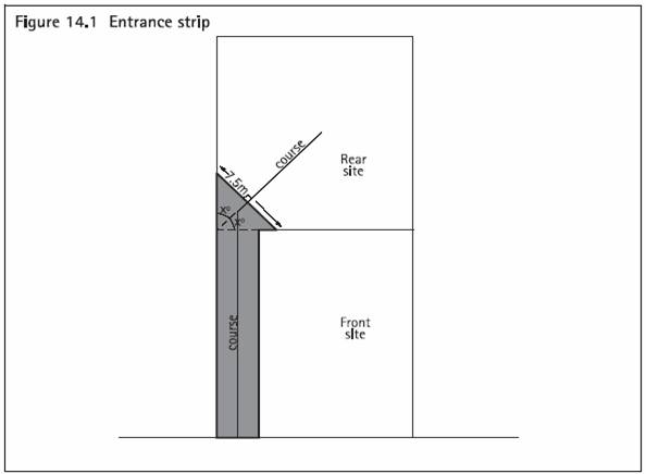
As illustrated in figure 14.1, entrance strips which are less than 7.5 metres
wide, are not capable of accommodating a dwelling and/or wastewater fields (this
is largely due to wastewater lines having to be 1.5 metres away from side boundaries
- refer to technical publication 58). Their primary function is to provide access
to and from a site.
The effective area for building on is restricted to the white area of figure
14.1 as you cannot build on the entrance strip. If we included the grey area as
well (i.e. gross site area) this would give a false impression of capacity to accommodate
development, as that area could not be used for stormwater and wastewater disposal.
Submissions
754/22,
859/22 state that the use of net site area conflicts with clause 12.9.3.3 which
uses the term gross site area. This relates only to the area on each proposed site
which contains the protected significant environmental feature (SEF). Minimum site
size for significant environmental protection subdivision is still based upon net
site area to ensure that there is sufficient open space available to service and
integrate the additional built forms.
It should be noted that the use of 'gross' site area in clause 12.9.3.3 has been
assessed as part of submissions relating to clause 12.9.3.1 in section 4.54 below.
Therefore, for reasons outlined above, it is recommended that the relief sort
with respect to the above submissions be rejected.
| Planner's recommendations about submissions seeking gross
site areas.
That submissions
618/77,
619/20,
1288/48,
2670/20
and 619/49,
754/58,
859/58,
2670/48
754/22,
859/22,
1101/9,
1289/10,
1286/78,
2878/79,
1127/21,
1287/4 be rejected.
|
4.13 Submission about land unit 10 and 12 being allowed on one title.
Submission dealt with in this section is
719/7.
4.13.1 Decision requested
The above submission requests the following:
Land unit 10 and land unit 12 being allowed on one title � they should be
subdivided as very confusing.
4.13.2 Planner's analysis and recommendation
The above relief being considered in this section of the report is too general
to be the basis of any recommended changes to Part 12 of the Plan.
Notwithstanding this, the following points may provide some clarity as to why
the submitter considers dual land units on one title leads to confusion:
- The address relating to this submission is stated as 18 Nepean Avenue, Waiheke
Island. Within the operative plan, this 4400m 2 site is classified
as land unit 12 (bush residential) and land unit 10 (forest and bush areas). These
dual land units are the result of a boundary adjustment undertaken in 2002 (SUB36020007101).
- Clause 12.6.6(1) of the plan currently states:
Where any proposed site in a subdivision application includes more than one
land unit, the subdivision rules which apply to the proposed site are the rules
for the land unit which forms the greatest part of the proposed site.
The above clause ensures that minimum site size as it relates to each land unit
is upheld so that the elements, features and patterns that contribute to the visual
amenity, natural landscape character and amenity value of each land unit are maintained.
For this reason, it is not considered that this clause should be removed or amended
from the Plan.
- Notwithstanding the above, dual land units on one site can lead to conflicting
land use activities. For example, within the operative plan, an entertainment
facility is a non-complying activity within land unit 12 however, it is a permitted
activity within land unit 10.
- It is evident that any subdivision within both the operative and proposed
plan as it relates to 18 Nepean Avenue will be a non-complying activity as the
minimum site size for land unit 10 (25ha) will not be achieved.
- With regard to this site, the proposed plan seeks to re-classify the entire
site of 18 Nepean Avenue as Island Residential 2 (bush residential). While this
matter will be assessed in another hearings report, it is considered that in the
event the re-classification of the site is accepted, the confusion noted in the
above relief may lessen as the site will not be subject to conflicting land use
activities and subdivision densities.
As stated above, the relief being considered in this section of the report is
too general to be the basis of any recommended changes to Part 12 of the Plan. On
this basis, it is recommended that the relief sought be rejected.
Planner's recommendations about submission seeking land unit 10 and 12 being
allowed on one title.
That submissions
719/7
be rejected.
4.14 Submissions about introducing non-complying activity status for all coastal
amenity area subdivision in excess of the minimum site sizes in tables 12.1 and
12.2.
Submissions dealt with in this section are as follows:
814/5,
959/4
4.14.1 Decision requested
The above submissions request the following:
Introducing non-complying activity status for all coastal amenity areas subdivision
in excess of the minimum site areas in tables 12.1 and 12.2
4.14.2 Planners analysis and recommendation
With regard to coastal amenity areas, as noted in section 4.7.2.1 above, the
land unit rules serve to protect coastal amenity in specific locations of island
residential 1 (traditional residential) by identifying these areas on the planning
maps as being within a "coastal amenity area". On Great Barrier Island, there are
also sub-areas within certain settlement areas which are identified as 'Reserve,
dune, coastal margin and wetland conservation areas'. Additional controls are imposed
on all buildings within these areas so they do not compromise the character and
amenity of the coast. Therefore, the Plan already provides for coastal amenity area
protection and enhancement at the time of land use development and as part of the
rules pertaining to landform 1, Island residential 1 as well as specific sub-areas
within settlement areas.
Tables 12.1 and 12.3 of the Plan outline minimum site size for landform 1, Island
residential 1 (whether or not land is identified as coastal amenity areas) as well
as sub-areas which are identified as 'Reserve, dune, coastal margin and wetland
conservation areas'. Clause 12.10 (Non-complying Activities) of the Plan identifies
specific subdivisions that are non-complying activities. The relevant provisions
relating to coastal amenity areas are as follows:
Non-complying activities
As shown in table 12.4: Activity table for all types of subdivision, the following
subdivisions are non-complying activities:
3. Any subdivision which does not meet the minimum site sizes specified in
table 12.1: Minimum site areas for land units, table 12.2: Minimum site areas for
protecting significant environmental features and table 12.3: Minimum site areas
for settlement areas.
5. Any subdivision in parts of settlement areas, where subdivision is identified
as a non-complying activity in table 12.3.
Accordingly, any subdivision within identified coastal amenity areas (island
residential 1), or in landform 1 (coastal cliffs and slopes) which does not meet
the minimum site size, is deemed to be a non-complying activity. In addition, table
12.3 states that subdivision in 'Reserve, dune, coastal margin and wetland conservation
areas' is a non-complying activity.
On this basis, the panel can be satisfied that the objectives, policies and rules
already contained in the Part 12 of the Plan have been written with the intention
of achieving the decision sought by the above submissions.
Therefore is recommended that the decision sought be accepted but no changes
to the Plan are required.
| Planner's recommendations about submissions seeking a non-complying
activity status for all coastal amenity area subdivision in excess of the minimum
site sizes in tables 12.1 and 12.2.
That submissions
814/5
and 959/4
be accepted but no changes to the Plan are required.
|
4.15 Submissions about providing for bridle paths
Submission dealt with in this section:
832/6,
1190/34,
1191/6,
852/2,
2922/2.
4.15.1 Decision requested
Submissions
832/6,
1190/34,
1191/6 request the following:
There should be a rule in the Plan for subdivision that bridle paths are put
in.
Submission
852/2 requests the following:
Add objectives, policies, rules and assessment criteria; in the general rules
- Subdivision provide for bridle paths in any subdivision.
Submission
2922/2
requests the following:
Provide for bridle paths in all subdivisions.
4.15.2 Planners analysis and recommendation
Bridal paths have not been included in Part 12 as it is considered that the provision
of bridle paths is a land use consideration that should be assessed at the time
of land use development. Part 10a (Land units: objectives, policies and activity
tables), Part 10b (Settlement areas: objectives, policies and activity tables),
(Part 13 (Connectivity and Linkages) and Part 6 (Financial Contributions) are appropriate
parts of the Plan in which to provide for bridal paths throughout the Hauraki Gulf
Islands. Accordingly, the above submissions seek amendments to other parts of the
Plan requesting the provision for bridal paths. Those subparts will be considered
in the hearing reports for those parts of the Plan.
In general, the Plan identifies existing bridle paths in Rangihoua but does not
seek to require any specifically. Notwithstanding this, such public access can be
made through financial contributions (Part 6) and through the taking of esplanade
reserves and esplanade strips (clause 12.13).
Objective 12.3.3 (public access to and along the coastline) provides a link to
these sections of the Plan as the policies seek to facilitate access to and along
the coastline, including rivers and lakes, while not adversely affecting the natural
character of these environments. The policies state the way in which access can
be acquired through financial contributions and through the taking of esplanade
reserves and esplanade strips.
These measures are contained in Part 6 (financial contributions) and clause 12.13
(Esplanade reserves). The rules contained within these parts outline how financial
contributions are levied through subdivision, which include the option of providing
open spaces or services instead of cash contributions. These provisions can enable
access to and along the coast, rivers and lakes and could include the provision
for bridal paths if offered by the applicant as part of a financial contribution
or esplanade strip.
For these reasons, it is recommended that submissions
832/6,
1190/34,
1191/6,
852/2,
2922/2 be rejected.
| Planner's recommendations about submissions seeking bridal
paths as part of subdivision.
Submissions
832/6,
1190/34,
1191/6,
852/2,
2922/2
be rejected.
|
4.16 Submission about no cross lease or unit title subdivision on Waiheke.
Submission dealt with in this section:
1015/8
4.16.1 Decision requested
Submission
1015/8 request the following:
That there is to be no cross leasing or unit title subdivision (on Waiheke).
4.16.2 Planners analysis and recommendation
In responding to the above submissions, it is considered necessary to address
the different forms of subdivision that occur in New Zealand and what a cross lease
and unit title subdivision consist of. Much of the following information is outlined
in the Quality Planning website:
Freehold subdivision
Freehold subdivisions occur where new allotments (usually referred to as sites)
are created under the Land Transfer Act and ownership is held in an estate in fee
simple. Fee simple means that the ownership of the land and the buildings on it
is held solely by those persons listed on the certificate of title. Freehold is
the most common form of subdivision. The boundaries are pegged by registered surveyors
and a 'guaranteed' title is issued.
Leasehold
Land or buildings or both that are leased for a period exceeding 35 years is
defined in the RMA as a subdivision. They are also known as leasehold subdivisions.
A leasehold estate is most commonly defined as an estate or interest in land held
for a fixed term of years. Ownership is through a lease from the owner of the freehold
title. Leaseholds usually operate under continually renewable terms, with a 'ground
rent' payable to the freehold title owner. The leaseholder effectively buys the
right to own the dwelling or building and lease the land for a certain time. The
leaseholder can sell the lease, but there are often restrictions on the use of the
property.
Cross lease
The formal name for a cross lease is a Composite Leasehold and Share Title. A
common example is two flats on one section and each person holds a leasehold of
one flat and an undivided share of the freehold section that both flats occupy.
As a consequence, each person is required to obtain the other person's consent to
alter or extend their flat, as both persons own half a share of the land.
The lease is for a period of 999 years and the share corresponds to the number
of dwelling units. The cross-lease plan shows the dwellings as "flats" and is often
called a "Flats Plan". The use of outdoor spaces is often defined by covenant (agreement)
areas which are also outlined on the plan.
Unit title
A unit title development (such as an apartment block) consists of:
- two or more principal units (to be used as a residence or business)
- the accessory units to be attached to the principal units (such as a garden,
garage, pool or carparking space)
- any common property (that is, common spaces such as lawns and driveways, and
common facilities such as lifts and laundries)
As a form of ownership, unit title is similar to other property in that it can
be bought and sold, or leased or mortgaged. However, unlike other forms of title,
it is made up of three components:
- ownership in the particular unit
- an undivided share in the ownership of the common property
- an undivided share in the ownership of the units if the unit plan is cancelled
In accordance with the above definitions, subdivision includes freehold subdivision
and lease hold subdivision. This includes the creation of fee simple sites, unit
titles, company lease or company titles and cross leases. Subdivision is therefore
the process of dividing a parcel of land or a building into one or more parcels,
or changing an existing boundary location.
The above forms of subdivision are expressly provided for within the RMA in accordance
with section 218 of the RMA. Pursuant to section 11 of the RMA, no person may subdivide
land (as defined by section 218 of the RMA) unless the subdivision is expressly
allowed by a rule in a plan or a resource consent, and a survey plan had been processed
under Part 10 of the RMA. Therefore, as the RMA expressly provides for such forms
of subdivision, Council must provide the opportunity to subdivide land under a cross
lease or unit title.
Therefore is recommended that the relief sought be rejected.
| Planner's recommendations about submission seeking that no
cross lease or unit title subdivision be provided on Waiheke Island.
That submission
1015/8
be rejected.
|
4.17 Submission about facilitating the clustering of built structures within
landform 6
Submissions dealt with in this section:
1098/2,
1099/2.
4.17.1 Decisions requested
Submissions
1098/2,
1099/2 request the following:
That the subdivision rule for landform 6 (regenerating slopes) should in addition
be characterised by appropriately sited clusters of buildings
4.17.2 Planner's analysis and recommendation
The above submitters consider that by allowing small scattered development within
this landscape will:
- Increase road and servicing impacts on slopes
- Undermine ecological continuity
- Limit social interaction and community development
- Result in inefficient development patterns
- Increase the visual impact (particularly on slopes)
- Lead to fragmentation of the landscape
The submitters therefore consider that the clustering of buildings in this landscape
in conjunction with recommended ecologically sustainable design guidelines will
minimise the above effects.
With regard to these matters, the following comments are made:
4.17.2.1 Resource Management Strategy
Clause 10a.7.1 of the Plan, outlines the characteristics of landform 6 (regenerating
slopes) which includes:
High natural visual prominence (in both coastal locations and as a backdrop
to settlement areas) and its unbroken expansive qualities;
Small, scattered and unobtrusive buildings, if there are buildings at all.
The ensuing objectives and policies of this land unit seek to maintain and protect
the above characteristics outlined in clause 10a.7.1.
Accordingly, the subdivision rules for landform 6 work together with other rules
for landform 6 (contained in parts 10a, 10c and 13) to achieve the resource management
strategy and objectives and policies for this land unit. This includes reducing
roading and servicing impacts and providing ecological continuity.
Therefore, while the decision sought by the submitters is in respect to the clustering
of sites as part of subdivision, any amendments made to part 12 (Subdivision) within
landform 6 may require consequential amendments to the resource management strategy
and objectives and policies for landform 6 as contained in part 10a.
4.17.2.2 Cluster subdivision
As stated in section 4.9 above, the proposed Plan provides for the clustering
of sites through clause 12.9.4 (cluster subdivision associated with the protection
of significant environmental features). This provision applies only to landforms
2-7 and rural 1 provided there is a significant environmental feature worthy of
protection
The clustering of buildings as part of a subdivision design is already provided
for within landform 6 (regenerating slopes) but only if there is an environmental
benefit gained through the protection of significant features, and provided the
effects on landscape character and amenity are not adversely affected. In many circumstances,
often the significant environmental feature itself, such as extensive bush, will
mitigate the effects of the clustering of built forms. This is because the massing
of built forms in an isolated area can be broken up by specimen trees and by an
extensive bush backdrop that surrounds the housing cluster.
It is not considered appropriate to provide for cluster subdivision in landform
6 where there is not a significant environmental feature worthy of protection and
there are no mitigating measures to integrate the built form into the landscape.
It is considered that the effects generated by clustering built forms into a landscape
which has high natural visual prominence (in both coastal locations and as a
backdrop to settlement areas) and has unbroken expansive qualities could
detract from the character and amenity of these areas if there are no mitigating
measures in which to integrate the massing of buildings. Accordingly, such an approach
is not consistent with the objectives and policies for landform 6.
4.17.2.3 Assessment of built forms in Landform 6 (regenerating slopes)
The submitters have also request that ecologically sustainable design guidelines
are included within the Plan.
Appendix 11 (Sustainable design guidelines for the islands) of the Plan outlines
sustainable measures for building and includes guidelines on the following:
- Sustainable design - starting out
- Earthworks
- Designing for the sun
- Energy
- Water
- Wastewater
- Low impact design
- Building in the bush
- Building materials
While Appendix 11 is not a mandatory document, the assessment criteria contained
in Part 11 (Assessment Matters) outlines matters that need to be considered when
assessing an activity for a discretionary activity as identified in the activity
tables contained in part 10a -Land units: objectives, policies and activity tables
and part 10b - Settlement areas: objectives, policies and activity tables. These
matters include the consideration of sustainable design for buildings.
Therefore, sustainable building design as sought by the above submitters is provided
for within the Plan for any land use application requiring discretionary activity
assessment in accordance with parts 10a and 10b.
4.17.2.4 Planner's recommendation
Overall, the panel can be satisfied that the objectives, policies and rules
already contained in the Part 12 of the Plan have been written to provide for cluster
subdivision in landform 6 providing there is a significant environmental feature
worthy of protection.
For reasons outlined above, it is not considered appropriate to provide for cluster
subdivision where there is no significant environmental feature worthy of protection
and there are no mitigating measures in which to integrate the built form into the
landscape.
In addition and as noted in section 4.17.2.1 above, the subdivision rules for
landform 6 work together with other rules for landform 6 (contained in parts
10a and 10c) to achieve the resource management strategy and objectives and policies
for this land unit. Consequently, these rules will ensure that the visual impact
of scattered buildings in the landscape and the effect on ecological continuity
will be assessed as part of any development for subdivision and land use development.
Therefore is recommended that the submissions
1098/2 and
1099/2 are accepted in part as the Plan already provides for a form of cluster
subdivision however, no further changes are recommended in the Plan.
| Planner's recommendations about submissions facilitating the
clustering of built structures within landform 6.
That submissions
1098/2,
1099/2 are accepted in part as the Plan already provides for a form of cluster
subdivision however, no further changes are recommended in the Plan.
|
4.18 Submissions about cluster subdivision in landforms 6 and 7 which follows
ecologically sustainable design principles.
Submissions dealt with in this section:
1098/1,
1099/1
4.18.1 Decision requested
Submissions
1098/1,
1099/1 request the following:
That subdivision rules for landform 6 (regenerating slopes) apply to landform
7 (forest and bush areas) specifically in the allowance to facilitate the clustering
of built structures, hamlets and villages in areas with the capacity to absorb growth.
That subdivision follows Ecologically Sustainable Design (ESD) principles.
4.18.2 Planner's analysis
The above submissions state that Great Barrier's identity is being challenged
and growth in population is likely to occur. It is therefore prudent to plan for
this growth in a sustainable manner. To meet this challenge, the submitters consider
that the existing landscape values and development patterns must be readdressed
to maintain the integrity of the island and absorb the pressures of population increases.
This could include the options of clustering housing and development pods within
close proximity using Ecologically Sustainable Design principles.
As stated in section 4.17.2.2 above, the Plan provides for the clustering of
sites through clause 12.9.4 (cluster subdivision associated with the protection
of significant environmental features). This provision applies only to landforms
2-7 and rural 1 provided there is a significant environmental feature worthy of
protection.
Accordingly, the clustering of buildings as part of a subdivision design is already
provided for within landform 7 (forest and bush areas) but only if there is an environmental
benefit gained through the protection of significant features, and provided the
effects on character and amenity are not adversely affected. In many circumstances,
the characteristic forest and bush areas within this land unit forms the significant
environmental feature itself, which also helps to mitigate the effects of clustered
built forms. This is because the massing of built forms in an isolated area can
be broken up by specimen trees and by an extensive bush backdrop that surrounds
the housing cluster(s).
4.18.2.1 Ecologically Sustainable Design (ESD) Principles
The submitters request that ecologically sustainable design principles are included
in the Plan which provides a framework to assess the design outcomes of subdivision
and associated development. This can be achieved through " sieve mapping and
land capacity study to assess areas that would be capable of supporting development
". There are three principles that encapsulate the ESD approach which include
addressing natural, urban, social and cultural needs of a site.
In analysing the decision sought by the submitter, it should be noted that further
growth and development on Great Barrier Island is envisaged for the settlements
areas. Indeed, the extent of the settlements areas is being reviewed and the intention
is to consolidate and provide for development in those areas.
With regard to providing growth in other land units, it is noted that a review
of the subdivision provisions has been undertaken after considerable landscape analysis
by John Hudson, a registered landscape architect. This work helped determine the
appropriate minimum site areas for land units and settlement areas, based upon the
physical characteristics of the land and its capacity to integrate development impacts,
as well as consideration of natural character, visual character and amenity values.
The policies and rules are therefore designed to promote and encourage subdivision
applications to meet minimum site sizes so that they are consistent with the objectives
and policies for each land unit or settlement area.
Accordingly, the objectives and policies for Landform 6 seek to limit activities
to those of a low intensity and to require buildings to be assessed so that there
will be no adverse effects on the natural character, ecological and visual amenity
values of the land unit. The objectives and policies for landform and 7 seek to
protect the conservation values associated with landform 7. These include, protecting
the extensive podocarp and broadleaf forest areas, areas of secondary regenerating
forest and some isolated areas of manuka and kanuka within this land unit. It is
considered that the continued implementation of 25 hectare site sizes will retain
and protect the natural character and general amenity value of the landform 7 (refer
also to section 4.79 below).
Therefore, it is considered that minimum site size is considered to be the only
practical and timely way to reflect land capacity, visual effects and the natural,
urban, social and cultural needs of a site. In addition, Council does not have the
resources to undertake site by site reviews of every piece of land in the Gulf to
determine areas of land that would be capable of supporting pockets of development.
Therefore, the minimum site sizes for each land unit focuses on the extent to which
proposed sites can be adequately serviced, and on the effects upon landscape character
and amenity values associated with additional built forms in the environment. Consideration
is also given to the protection and enhancement of the natural environment.
On this basis, the minimum site size method is the most appropriate way of addressing
subdivision given the nature of the district Plan. As such, it is recommended that
submissions
1098/1 and
1099/1 are rejected.
With regard to providing for Ecologically Sustainable Design (ESD) principles
and as stated in section 4.17.2.3 above, Appendix 11 (Sustainable design guidelines
for the islands) of the Plan outlines sustainable measures for building. While Appendix
11 is not a mandatory document, the assessment criteria contained in Part 11 (Assessment
Matters) outlines matters that need to be considered when assessing an activity
for a discretionary activity as identified in the activity tables contained in part
10a -Land units: objectives, policies and activity tables and part 10b - Settlement
areas: objectives, policies and activity tables.
Criterion 17 within Part 11 includes 'Sustainable building design' and assesses:
the extent to which the applicant has investigated alternatives in terms of
sustainable design such as 'green building' methods, renewable energy sources and
low impact design methods. (Appendix 11 - Sustainable design guidelines for the
islands can assist applicants with this criteria.)
Therefore, sustainable building design as sought by the above submitters is provided
for within the Plan for any land use application requiring discretionary activity
assessment in accordance with parts 10a and 10b.
| Planner's recommendations about submissions seeking
cluster subdivision to landforms 6 and 7 which follows ecologically sustainable
design principles.
That submissions
1098/1,
1099/1 be rejected.
|
4.19 Submissions about modifying subdivision rules pertaining to landform 7
to reflect land capacity and visual effects.
Submissions dealt with in this section:
1098/4,
1099/4
4.19.1 Decision requested
Submissions
1098/4 and
1099/4 request the following:
That the subdivision rules pertaining to forest and bush areas be modified
to reflect land capacity and visual effect, as opposed to a defined minimum site
size. This results in focusing on the effects of development in an environment of
development within an ESD Building Framework.
4.19.2 Planner's analysis and recommendation
The decision sought by the above submitters is similar to that which has already
been considered in section 4.18 above.
Accordingly, minimum site size is considered to be the only practical and timely
way to reflect land capacity and visual effects as requested by the submitters.
In addition, Council does not have the resources to undertake site by site reviews
of every piece of land in the Gulf. Therefore, the minimum site sizes for each land
unit focuses on the extent to which proposed sites can be adequately serviced, and
on the effects upon landscape character and amenity values associated with additional
built forms in the environment. Consideration is also given to the protection and
enhancement of the natural environment.
It is considered that the minimum site size method is the most appropriate way
of addressing subdivision given the nature of the district Plan. As such, it is
recommended that submission
1098/4 and
1099/4 are rejected.
| Planner's recommendations about submissions modifying subdivision
rules pertaining to landform 7 to reflect land capacity and visual effects.
Submission
1098/4 and
1099/4 are rejected.
|
4.20 Submission about notification so that access and reserve contributions
are not over looked.
Submission dealt with in this section:
1281/2
4.20.1 Decision requested
The above submission requests the following:
Subdivisions must all be notified so that possibilities for access and reserve
land contributions are not overlooked as is too often the case now.
4.20.2 Planner's Analysis and recommendation
In response to the above submission, it is considered appropriate to separately
turn to the provision for access and reserve contributions and notification within
Part 12:
4.20.2.1 Access and reserve land contributions
Provision for potential access and reserve land is a consideration in all subdivisions.
Indeed objective 12.3.3 and its policies state the following:
12.3.3 Public Access to and along the Coastline
To ensure that subdivisions facilitate access to and along the coastline while
not adversely affecting the natural character of the coastal environment.
Policies
- By taking esplanade reserves or esplanade strips at the time of subdivision.
- By requiring, at the time of subdivision, pedestrian links to and along
the coastline from public places.
- By facilitating, through subdivision, public access to the foreshore except
where restrictions are necessary because of safety, security, damage to vegetation
and wildlife, conflict with traditional Maori sites, or other exceptional circumstances.
- By using various measures including esplanade areas or financial contributions,
or both, to achieve public access to the coast, rivers and lakes.
The above policies are the most appropriate means of meeting section 6(d) of
the RMA and achieving the objective to facilitate access to and along the coastline,
including rivers and lakes, while not adversely affecting the natural character
of these environments.
The policies clearly state the way in which access can be acquired through financial
contributions and through the taking of esplanade reserves and esplanade strips.
Policy 3 also references matters that will be considered if an esplanade reserve
and/or esplanade strip is to be reduced, waived, cancelled or varied. This aspect
links to rule 12.13.2(1)(b) and assessment criteria 12.13.4 which considers all
applications to reduce, waive, cancel or vary esplanade areas as discretionary activities.
In addition, assessment criteria 12.11.5(8) (Site design and layout), 12.11.6(3)
(Access to sites) and 12.11.12 (1)-(3) (open space, recreation and financial contributions)
provide specific matters to consider when facilitating public access to and along
coasts, rivers and lakes. Applicants will therefore need to consider access (whether
public or private) to these areas as part of any subdivision.
Overall, the objectives, policies, rules and assessment criteria will facilitate
land contributions and access to coasts, rivers and lakes where practicable whilst
also ensuring that natural hazards are not exacerbated or created, and there are
no adverse effects on flora, fauna, landscape amenity or traditional Maori sites.
As part of any subdivision application, including restricted discretionary activities,
these objectives, policies, rules and assessment criteria particularly, within clause
12.13 (esplanade reserves) and Part 6 (Financial contribution) must be considered.
4.20.2.2 Notification
Section 93(1) of the RMA states that a consent authority must fully notify an
application for resource and/or subdivision consent unless the application is a
controlled activity, or the consent authority is satisfied that the adverse effects
of the activity on the environment will be minor.
Notwithstanding this, section 94 states that:
(1) If notification is not required under section 93(1), the consent authority
must serve notice of the application on all persons who, in the opinion of the consent
authority, may be adversely affected by the activity, even if some of those persons
have given their written approval to the activity.
(2) However, a consent authority is not required to serve notice of the application
under subsection (1) if all persons who, in the opinion of the consent authority,
may be adversely affected by the activity have given their written approval to the
activity.
On this basis, all discretionary and non-complying activity consents can be notified
(limited or fully) after an assessment of the effects of a proposed subdivision
has been undertaken. Council cannot notify an application unless it is considered
that the effects of the proposal will be more than minor and/or it is considered
that no persons will be adversely affected by the proposal.
Activity status of subdivision applications
Within Part 12, subdivision is either a permitted, (clause 12.7),restricted discretionary
(clause 12.8), discretionary (clause 12.9) or a non-complying activity (clause 12.10).
Restricted discretionary applications (12.8) include: company leases, unit titles,
boundary adjustments and the creation of rights of way. In addition, subdivision
including cross leases in landforms 1-7, island residential 1 and 2 and rural 1
which meets minimum site size (table 12.1) and the general rules in clause 12.6
are restricted discretionary activities.
Notwithstanding this, the provision for non-notification pursuant to section
94D(2) and (3) of the RMA has not been included for such restricted discretionary
activities within part 12. Therefore, restricted discretionary activities can be
notified and potentially declined if the matters over which Council has restricted
its discretion will generate adverse effects that are more than minor.
Discretionary applications within part 12 (clause 12.9) include subdivision for
the purpose of protecting Significant Environmental Features and all subdivision
within commercial 1-5, recreation 1-3, rural 2 and 3, Pakatoa, Matiatia and within
the settlement areas provided, the subdivision meets general rules in clause 12.6
and the specific standards and terms relevant to the land unit.
It should be noted that, where any subdivision proposal (including restricted
discretionary activities noted in clause 12.8) does not meet particular general
rules and/or standards and terms, then the activity status of an application is
likely to change. Non-complying activities are contained in clause 12.10 and include
the subdivision of any land which does not comply with the relevant site sizes contained
in tables 12.1 and 12.2.
On this basis, all restricted discretionary, discretionary and non-complying
activity consents may be notified (limited or fully) after an assessment of the
effects of a proposed subdivision has been undertaken. Council cannot notify an
application unless it is considered that the effects of the proposal will be more
than minor and/or it is considered that no persons will be adversely affected by
the proposal. Each application must be assessed on a case by case basis and on its
merits.
Therefore for reasons outlined above, it is considered that submission
1281/2 be
rejected as the Plan has been written to ensure that all subdivision applications
must be assessed against the provisions relating to the taking of esplanade reserves
(clause 12.13) and Part 6 (financial contributions. In addition, (with the exception
of permitted activities) all have the potential to be notified however, such a determination
must be assessed on a case by case basis and on its merits. On this basis, subdivision
applications cannot be automatically notified without a proper assessment of effects
pursuant to sections 93 and 94 of the RMA.
| Planner's recommendations about submission seeking notification
so that access and reserve contributions are not over looked.
Submission
1281/2
be rejected.
|
4.21 Submissions about providing more flexible and diverse opportunities for
land use development outside of the existing settled areas.
Submission dealt with in this section:
1284/9,
2878/107
4.21.1 Decision requested
Submission
1284/9
requests the following:
Amend the subdivision provisions for all rural zones (including non-conservation
Islands) to incorporate more flexible and diverse opportunities for land use and
development outside of the proposed strategic limitations imposed by the proposed
focus on concentrating development within existing settled areas with limited subdivision
and use options elsewhere .
Submission
2878/107
requests the following:
The proposed subdivision provisions (for rural 1 and 2) need amending to incorporate
more flexible and diverse opportunities for land use and development outside of
the proposed strategic limitations imposed by the proposed focus on concentrating
development within existing settled areas with limited subdivision and use options
elsewhere.
In order to facilitate the above requests, the above submissions seeks comprehensive
management plans (CMPs) for all rural land units that assesses the whole of a property
and includes land management, enhancement and environmental protection outcomes.
4.21.2 Planner's Analysis and recommendation
In responding to the above submissions, it is considered appropriate to assess
the following:
CMPs
The provision for CMP's has already been assessed in section 4.9 above whereby
it was concluded that the objectives, policies and rules already contained in the
Part 12 of the Plan have been written with the intention of achieving an integrated
approach to land use that assesses the whole of a property and includes land management,
enhancement and environmental protection outcomes. On this basis, it is not considered
necessary to provide for a "Comprehensive Management Plan" as it will not achieve
a more effective sustainable management of resources associated with subdivision.
Provide for more flexible and diverse opportunities for land use and development
outside of the existing settled areas,
With regard to the above relief, it is important to note that the subdivision
rules have been written with the intent on concentrating subdivision and development
in either settlement areas or where built form has already modified the natural
character and the effects of further development can be mitigated (refer to policy
2 of objective 12.3.1).
Such an approach is consistent with the resource management strategy and objectives
and policies of each settlement area and/or land unit as it ensures that development
is located in areas which have the capacity to integrate development impacts without
adversely affecting the character and amenity of the surrounding landscapes, particularly
rural landscapes and residential and recreational areas. Accordingly, there are
specific land units and settlement areas which provide for more intensive development
opportunities both in terms of land use and subdivision potential. Conversely, other
land units provide land use opportunities which require larger areas of land to
ensure that the open landscape is protected.
As submitter 1284 is a Great Barrier Island resident, an appropriate example
of concentrating development within specific areas can be seen in the settlement
areas located only on Great Barrier Island. These areas have historically been areas
of settlement and they are important centres of community for the people of Great
Barrier. Some of these settlements have the capability to grow into the future,
while others are recognised as needing to be contained within existing areas due
to the fragile or sensitive nature of the surrounding environment.
The settlement plans have been developed to enable an integrated approach to
resource management for the settlement areas. They recognise issues around reverse
sensitivity by locating similar activities in the same locations, and enable a framework
for sustainable management for activities on the island. Where growth, including
subdivision, is to occur, it is encouraged within or around the settlement areas
rather than compromising the landscape values of outlying areas.
Providing for subdivision and more diverse land use opportunities outside settlement
areas, may lead to the modification of surrounding rural landscapes (land units
1-7) which would adversely affect the elements, features and patterns that contribute
to the visual amenity, natural landscape character and amenity value of these land
units. It is considered that concentrating subdivision and development in either
settlement areas or where built form has already modified the natural character,
and the effects of further development can be mitigated, will secure appropriate
management of resources and achieving sustainable land use development.
For these reasons, it is recommended that the submissions
1294/9 and
2878/107
be rejected.
It should also be noted that, throughout the hearing process the council will
consider submissions which seek that specific rules be eliminated or relaxed; these
submissions may seek to achieve a more proactive approach to sustainable development
that is being sought by submissions
1284/9
and
2878/107. In addition, submissions 1284 and 2878 also contain other subparts
which will also be considered in other hearing reports.
| Planner's recommendations about providing more flexible and
diverse opportunities for land use development outside of the existing settled
areas.
That submission
1284/9
and
2878/107 be rejected.
|
4.22 Submission about bonus density provisions.
Submissions dealt with in this section:
1287/59,
1287/61,
1289/14,
1288/62,
1289/30
4.22.1 Decisions requested
Submission
1287/59 requests the following:
The Plan should include provisions providing a comprehensive management approach
to residential subdivision whereby bonus density is enabled at a ratio in relation
to securing areas of protected land and management and environmental enhancement
proposals including re-plantings of native vegetation;
Submission
1287/61,
1289/14 request the following:
The subdivision rules for the residential zones on Waiheke in relation to
any sites over 6000m2 should include a provision for a bonus density regime, being
the equivalent of the rural significant environmental feature type approach but
in a urban context, as a means of securing higher residential density within a bush
protection environment and should allow cluster development to occur within such
land up to a maximum density of one dwelling/ 1000m2 only where communal infrastructure
is proposed and where significant environmental feature type protection covenants
secure the greater (>50%) proportion of the site;
Submission
1288/62
requests the following:
For landforms 2, 4-7, beyond the baseline minimum lot size areas in Table
12.2 (as modified by the submitters separate submission), the Plan should include
provisions providing a bonus density approach to rural land use and subdivision
whereby an appropriate density is determined by a ratio in relation to sustainability
and management enhancements including areas of protected land, open space and land
management and enhancement proposals including re-plantings of native vegetation
and management of water systems. Thus for every 4 ha of additional significant environmental
feature type outcome secured beyond a baseline requirement of 50% of parent site,
sustainability managed/protected/enhanced two addition lots beyond the (submitters
proposed) Table 12.2 density regime should be enabled. The bonus provisions should
enable a conjunctive application for removal of vegetation to obtain vehicle access
and provide for dwellings as a discretionary activity.
Submission
1289/30 requests the following:
Include provisions providing a comprehensive management approach to residential
subdivision whereby bonus density is enabled at a ratio in relation to securing
areas of protected land and management and environmental enhancement proposals including
re-plantings of native vegetation.
4.22.2 Planner's Analysis and recommendation
The above submissions seek to increases densities that are higher that those
provided for as part of Significant Environmental Feature subdivision (SEF - refer
section 4.9.2.4 above). Increasing densities is therefore based on the quantity
of the environmental feature proposed for protection.
In responding to the above submissions, it is considered necessary to separate
two distinct matters contained in the above decisions: Bonus densities within
residential land units and, increasing densities above those provided for as part
of any SEF subdivision.
4.22.2.1 Bonus densities in residential land units
It is considered that providing for bonus densities within residential land units
where there is environmental protection will result in the proliferation and clustering
of built forms within the residential landscape. Such a clustering of buildings
could lead to adverse effects on the landscape and amenity values of these areas.
An assessment regarding the clustering of buildings as part of environmental protection
within residential land units has already been assessed in section 4.11 above.
To this end, it is not considered appropriate to provide for bonus density provisions
in exchange for environmental protection within residential landscapes. In addition,
the protection of environmental features is already assessed as part of any subdivision
within residential land units. This assessment is contained in criteria 12.11.12
(open space, recreation and financial contribution); 12.11.13 (protecting vegetation
and landscape); and 12.11.1.4 (preserving and enhancing heritage features). Further
protection and enhancement can also be achieved as part of land use consents.
4.22.2.2 Bonus density regime in landforms 2-7 and rural 1
As noted in section 4.9.2.4 above, the Plan provides for the protection of significant
environmental protection in clauses 12.9.3 (protection of significant environmental
features) and 12.9.4 (cluster subdivision associated with the protection of significant
environmental features). When subdividing for the purposes of significant environmental
features, the minimum site size for the land units are markedly reduced on the basis
that there is an environmental benefit gained and the additional built forms are
integrated into the landscape.
The above submissions seek the same environmental outcome as envisaged in clauses
12.9.3 and 12.9.4 however, the submitters consider that bonus density provisions
should be based solely on the amount of land that is available for environmental
protection. This approach fails to take into consideration that minimum and average
site sizes contained in tables12.1 and 12.2, are based not only on the physical
characteristics of the land and its capacity to integrate development impacts, but
also on the natural character, visual character and amenity values that contribution
to the land units and the overall character of the Hauraki Gulf Islands.
It is recognised that the management and enhancement of areas of protected land
and open space will provide for growth and safeguard the life-supporting capacity
of the air, water, soil and ecosystems (section 5(2) of the RMA), however it is
considered that a balance also needs to be struck between environmental protection,
providing greater densities and retaining natural character, visual character and
amenity values of the land units. It is also the character of the locality that
contributes to the overall character of the Hauraki Gulf Islands, and makes it a
desirable place to live.
Given the comments made above, it is considered that the decision sought would
fail to be consistent with the resource management strategy, objectives and policies
of each land unit which seek to ensure that landscape and amenity values are not
adversely affected. Therefore, while environmental protection and enhancement is
a positive effect that is generated on the environment, the effects of additional
built forms and the modification of the environment may adversely affect the landscape
character of the area. By introducing additional built forms based solely on a quantitative
area subject to protection, does not consider the effects on landscape amenity of
the additional built forms.
In addition, it is considered that providing for bonus densities through the
protection of environmental features will not generate greater environmental benefits
above what can already be achieved through significant environmental feature subdivision
contained in clauses 12.9.3 and 12.9.4 of the Plan. Moreover, the provision to take
land for the purposes of land management and environmental enhancement can also
be achieved through financial contributions and under section 230 of the Act (Requirement
for esplanade reserves or esplanade strips).
Therefore, providing for bonus density provision is not consistent with the objectives
of securing appropriate management of resources, nor is it consistent with achieving
sustainable land use development.
For these reasons, it is recommended that submissions
1287/59,
1287/61,
1289/14,
1288/62,
1289/30 be rejected.
4.23 Submission about preventing degradation of the landscape
Submission dealt with in this section:
1816/7
4.23.1 Decision requested
Submission
1816/7
requests the following:
Tighten up on discretionary consents to prevent further fragmentation, degradation
of the landscape.
4.23.2 Planners analysis and recommendation
The submission being considered in this section of the report is too general
to be the basis of any recommended changes to the Plan. In addition, the submission
does not specifically identify any changes needed to tighten up on discretionary
consents to prevent further fragmentation, degradation of the landscape. Accordingly,
submitter
1816/7
is invited to provide clarification at the hearing as to how Part 12 should be amended
to prevent further fragmentation, degradation of the landscape.
Notwithstanding this, the objective, policies and rules within part 12 take into
account that the physical and natural environment in the islands creates major constraints
on subdivision. In particular, there is a need to preserve the natural environment,
visual character, amenity, and heritage values and to have regard to drainage capability.
The proposed Plan provisions recognise the potential for adverse effects that may
arise from subdivision within and associated with the coastal environment. Furthermore,
the significant ecological and landscape values of the islands, as recognised in
regional planning documents, require that subdivision should only occur on sites
where there is adequate physical capacity and capability to integrate development
impacts. As such, the proposed objectives, policies and rules give particular emphasis
to ensuring a proper assessment of such effects when subdivision applications are
evaluated.
Throughout the hearing process the council will consider submissions which seek
that specific rules be eliminated or relaxed; these submissions may seek to achieve
a more restrictive approach to sustainable development that is being sought by submission
1816. Indeed, this submitter has lodged other submissions which will be considered
in other hearing reports.
For these reasons, it is recommended that submission
1816/7
be rejected.
| Planner's recommendations about preventing degradation of
the landscape.
That submission
1816/7
be rejected.
|
4.24 Submission about effects from increased valuations
Submission dealt with in this section:
1823/7
4.24.1 Decision requested
Submission
1823/7 requests the following:
There needs to be protection for rural landowners so that they are not forced
into subdividing rural land because of a valuation/rating assumption that they will
or should. Rural land needs to be treated as rural land, not potential residential.
4.24.2 Planners analysis and recommendation
This submission does raise an issue about how district plan provisions are taken
into account in valuing a property. While property values are influenced by district
plan rules, the process of property valuation is outside the scope of the Plan.
Notwithstanding the above, it is noted that, the objectives policies and rules
for subdivision seek to protect the quality and diversity of the natural environment
and the visual character associated with rural land units. Within rural land units,
minimum site sizes have been formulated to provide for productive activities that
require large site sizes, particularly within landform 5, which seeks to provide
and encourage pastoral farming and horticulture.
On this basis, the minimum and average site sizes outlined in tables 12.1 and
12.2 are not based on providing for residential development as the primary use on
sites rather, they are based on providing for rural related activities within these
land units
As the decision sought by submission
1823/7 is
outside the scope of the Plan, it is recommended that it be rejected.
| Planner's recommendations about effects from increased valuations.
That submission
1823/7
be rejected.
|
4.25 Submission about land divided by formed or unformed legal roads.
Submission dealt with in this section:
1895/1,
1895/2
4.25.1 Decision requested
Submission
1895/1
requests the following:
Where a property /title is divided by a legal road or a legal unformed road,
subdivision of the property which reflects the division should be a permitted activity.
Submission
1895/2
requests the following:
Where a property/ title is divided by a legal road or a legal unformed road
the minimum site size should be 1500sm.
4.25.2 Planner's analysis and recommendation
It is recognised that subdividing a site which is cut off from the balance of
a site by the formation of a public road may reduce managerial costs associated
with having several "pieces" of land. For example, when farming, containing live
stock within separate pieces of land may be costly to manage and difficult when
moving stock across the roads.
Notwithstanding this, the minimum site sizes proposed for each land unit and
settlement area (tables 12.1 and 12.3) are based upon the physical characteristics
of the land and its capability to integrate development impacts as well as consideration
of natural character, visual character and amenity values of each land unit.
Subdividing areas which are separated by a formed or unformed legal road and
which do not meet the minimum site size for the land unit, can increase the building
development above what would have been anticipated had the site not been subdivided.
This increases the modification of the environment, through additional built forms,
earthworks and vegetation removal and can lead to adverse amenity effects which
detract from the character of the environment and undermine the resource management
strategy and objectives and policies for the land unit.
Ensuring that sites divided by roads meet the minimum site size for both the
land unit is consistent with the resource management strategy and objective and
policies for each land unit.
In light of the above, it is recommended that the above submissions be rejected.
| Planner's recommendations about land divided by formed or
unformed legal roads.
That submissions
1895/1 and
1895/2 be rejected.
|
4.26 Submission about providing for retirees.
Submission dealt with in this section:
2048/2
4.26.1 Decision requested
Submission
2048/2
requests the following:
That the Plan make provision under part 12 (subdivision) for town house sized
subdivision for retirees with appropriate resource and infrastructure controls.
4.26.2 Planners analysis and recommendation
Accommodation for retired, elderly or disabled people is provided for as a discretionary
activity within Island residential 1 and 2, commercial 1, 2, 3 and within the residential
amenity areas, local retailing areas within the settlement areas. This provides
for shared accommodation, serviced apartments or small self-contained dwellings.
In accordance, the definition of this activity in part 14 (definitions), any serviced
apartments or dwellings must be either, part of a development undertaken by a registered
charity, society or public body, held together in one title or be held in unit titles.
This ensures that any retirement village is managed as one site and for the sole
purpose of providing accommodation, welfare and where appropriate, medical facilities
to an aging population. Given the intensity of such an activity, it is likely that
shared facilities in the form of wastewater, stormwater and even potable water will
be shared by the collective units.
Providing for housing development for retirees is therefore recognised within
the Plan but notwithstanding unit title subdivision, it does not provide for each
unit to be subdivided into freehold sites. Such an approach would not meet the definition
of 'Accommodation for retired, elderly or disabled people' as the development would
not be held together in one title.
In addition, creating ' town house sized subdivision ' for the purposes
of retirees undermines the purpose of identifying minimum site sizes, and may detract
from the character of the environment and be contrary to the resource management
strategy and objectives and policies for the land unit. In addition, it is unlikely
that " town house sized subdivision " could adequately service development
on freehold sites (e.g. wastewater).
As stated earlier in this report, while consideration is given to the effects
of additional built forms as part of the assessment of any subdivision proposal,
to ensure best planning practice, it is not appropriate to include an assessment
of land use activities as part of subdivision applications. Accordingly, providing
for town houses for retirees should be assessed as part of the resource management
strategy for the land units themselves rather than at the time of subdivision. This
approach will ensure consistency in the rules within the proposed plan and avoid
repetition.
In light of the above, it is recommended that the above submission be rejected.
| Planner's recommendations about providing for retirees.
That submission
2048/2
be rejected.
|
4.27 Submission about not finalising part 12 until the level and growth of the
community is clarified.
Submission dealt with in this section:
3061/110
4.27.1 Decision requested
The above submission requests the following:
That Part 12.0 Subdivision is opposed in its present form and that finalisation
of this part be held in abeyance until the final shape and priorities within the
Plan are clarified, especially in relation to what level and style of growth is
mandated by the community.
The above submission considers that the Plan is does not demonstrate clear policy
commitments and objectives specific to growth.
4.27.2 Planner's analysis and recommendation
The above submission makes various general statements of a philosophical and
ideological nature without seeking any specific decision. Accordingly, submitter
3061 is invited to provide clarification at the hearing as to how Part 12 should
be amended in order to demonstrate clear policy commitments and objectives specific
to growth.
Given the lack of specific direction of submission
3061/110, it is recommended that it be rejected.
| Planner's recommendations about finalising part 12 until the
level and growth of the community is clarified.
That submission
3061/110 be rejected.
|
4.28 Submission about prohibiting subdivision on ridgelines
Submission dealt with in this section:
3076/1
4.28.1 Decision requested
The above submission requests the following:
The plan to recognise that further subdivision on ridgelines and visually
sensitive areas be prohibited.
The above submission considers that there have been inappropriate subdivisions,
building platform and buildings permitted on ridgelines and in the coastal environment.
4.29 Planner's analysis
In responding to the above submission, it is considered necessary to turn to
the ridgeline controls as contained in both the operative and proposed Plans.
Application of ridgeline control
As illustrated throughout the Islands, some buildings have been located on significant
ridgelines. An assessment of a building located above a ridgeline requires discretionary
activity resource consent within both the operative and proposed Plans and is subject
to an assessment in terms of their scale form, finish and overall visual impact
on the environment.
In some circumstances, comprehensive subdivisions have located building platforms
on or near ridgelines. This can be seen along Nick Johnstone Drive, Church Bay Road
and Delamore Drive. At that time, building platforms were located on or near ridgelines
as the operative Plan allowed for buildings on a ridgeline, provided they met the
standards contained in either 6B.1.2.6 which requires that buildings are located
below a significant ridgeline or, section 6C.1.2.6 as follows:
Where any building is located within 100 metres either side of a significant
ridgeline (measured on a horizontal plane) shown on the planning map:
- the building shall not exceed 4 metres in height above the significant
ridgeline, and
- the building shall be designed, constructed and located so that its visual
impact is mitigated by vegetation and/or earthworks, and
- any trees, shrubs, stands of bush or landforms which mitigate the visual
impacts and enable consent to be granted shall be protected by a consent notice
or similar mechanism.
Provided the above standards were met, then the operative Plan stated that the
application would not be notified. On this basis, the operative Plan anticipated
some level of development on or near ridgelines provided the scale form and finish
of the building meet specific standards and the effects on the environment were
no more than minor. This approach resulted in some subdivisions locating building
platforms on or near ridgelines as the bulk and location controls provided for some
level of development.
Clause 10c.4.7 of the proposed Plan states:
10c.4.7 Ridgeline control
Any building within a significant ridgeline area identified on the planning
maps must be
constructed and located so that:
- The building is below the significant ridgeline at that point; or
- The building is below the top of protected vegetation (located on the same
site as the building) that either screens the building or forms a backdrop against
the ridgeline at that point.
Protected vegetation means any vegetation that is protected by:
- The indigenous vegetation protection rules in clause 10c.5.1; or
- The exotic tree protection rules in clause 10c.5.2; or
- A legal covenant with council under the Land Transfer Act 1952.
Explanation
Buildings that protrude above significant ridgelines can compromise the visual
landscape qualities of the ridge and appear visually obtrusive giving rise to adverse
visual effects. The location and height of buildings within 100m either side of
a significant ridgeline is therefore controlled to manage the adverse visual impact
that can occur when a building protrudes above the ridgeline.
The location of a building above a ridgeline, which does not meet the above standards,
requires discretionary activity resource consent. There are no standards within
the Plan which provide for buildings located above the ridgeline to be non-notified.
Therefore, every resource consent application to locate a building on a ridgeline
must be assessed on a case by case basis and upon its merits. As a discretionary
activity, a resource consent application to locate a building on a ridge can be
notified and declined if the effects on the environment are more than minor.
On this basis, the Plan anticipates at a discretionary level, some form of building
on a ridgeline provided the scale, form and finish of a building does not adversely
affect the environment.
Ridgeline assessment as part of subdivision
While the ridgeline controls are a land use matter which are considered at the
time of development, as part of any subdivision application, clause 12.6.1 of the
Plan states that each proposed site must demonstrate where a building, access and
parking can be constructed which complies with specific development controls, this
includes clause 10c.4.7 (ridgeline control). In the event that a subdivision application
cannot demonstrate that buildings can be located below a significant ridgeline,
then a discretionary activity consent is required and the effects on locating buildings
on a ridgeline will be considered as part of the subdivision assessment.
In some circumstances, building platforms may be placed on titles by way of consent
notices to ensure that built forms are located below the ridgeline. Alternatively,
covenants can also be imposed which restricts the height of a building above a ridgeline.
On this basis, the panel can be satisfied that as part of any subdivision application,
consideration is given to the effects of establishing built forms on significant
ridgelines and visually sensitive areas.
4.29.1 Planner's recommendation
The location of buildings on or near ridgelines and visually sensitive areas
is assessed as part of the bulk and location controls within both the operative
and proposed Plans. Therefore, it is considered that prohibition of buildings on
or near ridges and visually sensitive areas is unnecessary when the Plan provides
enough controls and considerations to ensure that the visual impact of development
within these areas can be adequately assessed.
On this basis, it is not appropriate for subdivision to prohibit the location
of buildings on ridgelines. This is primarily a land use matter which must be assessed
on a case by case basis and as part of the resource management strategy for the
Hauraki Gulf Islands.
In light of the above, it is recommended that submission
3076/1 be
rejected
| Planner's recommendations about prohibiting subdivision on
ridgelines.
That submission
3076/1
be rejected.
|
4.30 Submission about subdividing land contaminated by weed spray
Submission dealt with in this section:
3501/11
4.30.1 Decision requested
Submission
3501/11
seeks the following:
Seeks the ability to subdivide any land contaminated by weed spray by the
council.
The above submission raises a specific matter pertaining to Council's use of
spays in relation to the submitter's land.
4.30.2 Planner's analysis and recommendation
Subdividing on the basis that land is contaminated by weed spray undermines the
purpose of having minimum site sizes, which seek to preserve the natural character
of the land units and settlement areas and relate minimum areas based on their physical
and natural character, use and potential. Such an approach is not consistent with
the objectives of securing appropriate management of resources, or consistent with
achieving sustainable land use development.
On this basis, it is recommended that submission
3501/11
be rejected.
| Planner's recommendations about subdividing land contaminated
by weed spray.
That submission
3501/11
be rejected.
|
4.31 Submission about subdividing 80 Schooner Bay Road, Great Barrier Island.
Submission dealt with in this section:
3501/8
4.31.1 Decision requested
The above submission seeks the following:
Seeks the ability to create 5 sections of 1000m2 on the Schooner Bay frontage
of the property at 80 Schooner Bay Rd, Tryphena, Great Barrier.
4.31.2 Planners analysis and recommendation
This subdivision proposal will be for the purpose of providing "budget land"
for housing and accommodation for residents unable to afford land on Great Barrier
Island. The submitter seeks that this land (80 Schooner Bay Road) is reclassified
into "residential" so that five sections of 1000m 2 are created.
80 Schooner Bay Road is classified as landform 6 (regenerating slopes) in the
Plan and comprises 44768m 2. The minimum site size in table 12.1 for
landform 6 is 25 ha. In accordance with clause 12.9.3 and table 12.2, the minimum
site size can reduce to 4ha with an average of 7.5 ha.
The reclassification of the subject site into "residential" will be the subject
of a separate hearings report. Should council elect to reclassify this site, then
consequential amendments may be made in Part 12.
The submitter should be made aware that at present the above form of subdivision
is a non-complying activity, as it does not meet the minimum site sizes contained
in tables 12.1 and 12.2. As a non-complying activity, the proposal will need to
pass the "gateway tests' contained in section 104D of the RMA:
"a consent authority may grant a resource consent for a non-complying activity
only if it is satisfied that either �
(a) the adverse effects of the activity on the environment (other than any
effect to which section 104(3)(b) applies will be minor; or
(b) the application is for an activity that will not be contrary to the objectives
and policies of-
(i) the relevant plan, if there is a plan but no proposed plan in respect
of the activity; or
(ii) the relevant proposed plan, if there is a proposed plan but no relevant
plan in respect of the activity; or
(iii) both the relevant plan and the relevant proposed plan, if there is both
a plan and a proposed plan in respect of the activity."
Such an assessment will be undertaken at the time of processing and based upon
the merits of the application. For this reason, no further assessment can be made
with regard to the above submission.
In light of the above, it is therefore recommended that submission
3501/8
be rejected.
| Planner's recommendations about subdividing 80 Schooner Bay
Road, Great Barrier Island.
That submission
3501/8
be rejected.
|
4.32 Submission about mitigating cumulative effects.
Submission dealt with in this section:
3574/3
4.32.1 Decision requested
Submission
3574/3 seeks the following:
Lot size must be carefully managed to avoid rather than mitigate the cumulative
effects of that development on the environment and ecology of the particular area,
and the wider island region
4.32.2 Planner's analysis and recommendations
Submission
3574/3 is considered too general to be the basis of any recommended changes
to part 12 of the Plan. Indeed, the above submission makes various general statements
of a philosophical and ideological nature relating to conservation without seeking
any specific decision.
It should be noted that the purpose of the RMA is 'to promote the sustainable
management of natural and physical resources'. Sustainable management is defined
in s5(2) and is also set out in section 2.0 of this document. Section 5(2)(b) and
5(2)(c) state:
(b) Safeguarding the life-supporting capacity of air, water, soil, and ecosystems;
and
(c) Avoiding, remedying, or mitigating any adverse effects of activities on
the environment."
Therefore, the Plan does not have to only avoid adverse effects, if remedying
or mitigating effect will achieve sustainable management.
It is recommended that submission
3574/3 be rejected as it makes various general statements of a philosophical
and ideological nature without seeking any specific decision.
| Planner's recommendations about mitigating cumulative effects.
That submission
3574/3 be rejected.
|
4.33 Submission about subdivision within 4 kilometres of Orapiu Wharf.
Submission dealt with in this section:
3712/2
4.33.1 Decision requested
The above submission seeks the following:
Delete any provision which is more permissive of land subdivision within 4
kilometres of Orapiu Wharf.
4.33.2 Planner's analysis and recommendation
Submission 3712 being considered in this section of the report is too general
to be the basis of any recommended changes to part 12 of the Plan. Indeed,
the above submission makes a general statement regarding the removal of permissive
provisions within 4 kilometres of Orapiu Wharf, but does not identify why the relief
is sought and what amendments, if any, are sought to the Plan to address this matter.
Within a 4 kilometre range, land surrounding Orapiu Wharf comprises a range of
land units including Island residential 2, recreation land and landforms 1-7. Consistent
with the resource management strategy contained in clause 3.3.5 of the Plan, the
land units located within this radius seek to provide for large-scale rural activities
to occur in eastern Waiheke. The strategy also seeks to protect the landscape character
of Waiheke, natural features such as wetlands, native vegetation and wildlife habitats
and waahi tapu and other taonga. The strategy also seeks to regulate the use and
development of land for conservation, recreation and community services and to allow
the development of essential infrastructure.
It is considered that removing the "permissive" provisions within 4 kilometres
of Orapiu Wharf, may undermine the resource management strategy envisaged for the
eastern Waiheke, which is not consistent with the objectives of securing appropriate
management of resources, or consistent with achieving sustainable land use development.
The significance of the 4kn radius from Orapiu is therefore not clear.
For reasons set out above, it is recommended that submission
3712/2
be rejected.
| Planner's recommendations about subdivision within 4 kilometres
of Orapiu Wharf.
That submission
3712/2
be rejected.
|
4.34 Submission about public recreation and public visitor activities within
Rotoroa.
Submission dealt with in this section:
947/2
4.34.1 Decision requested
The above submission seeks the following:
Subdivision options should be provided where public recreation or public visitor
related activities are established/proposed and require leases over 35 years such
that subdivision is deemed to occur. Such subdivision should be provided for as
a restricted discretionary activity (with specific reference to Rotoroa).
4.34.2 Planner's analysis and recommendation
Clause 12.10(6) states that any subdivision in the Rotoroa land unit is a non-complying
activity. Subdivision in this context refers to the creation of freehold sites
only. Accordingly, lawfully established buildings on the Rotoroa island are able
to be unit titled and/or leased for longer than 35 years in accordance with clauses
12.8.1(1) and 12.8.1 (3) of the Plan. Restricted discretionary activity consent
is required for any form of unit titling and/or leasing. This is illustrated in
table 12.4 (Activity table for all types of subdivision).
Therefore, unit titling and leasing on Rotoroa as restricted discretionary activities
is already provided for within the Plan however, it is accepted that this is not
clearly stated within the Rotoroa land unit provisions. It is further noted that
several submissions have requested similar decisions in the following sections of
the report. Accordingly, it is evident that the Plan does not specify that in many
land units, leasehold subdivision may still occur on sites which may not be able
to be subdivided into freehold sites.
To provide clarity on this matter, it is recommended that table 12.4 (Activity
table for all types of subdivision) is relocated immediately after clause 12.5 (Content
and Structure) so that people can determine relatively quickly which subdivision
provisions relate to a specific land unit and settlement area and the activity status
of these types of subdivision. Therefore, where land may not be subdivided into
freehold sites (including cross leases) as they are non-complying activities, this
does not preclude a site being subdivided into a leasehold estate such as a company
lease and/or unit title. Such forms of leasehold subdivision must still comply with
the relevant standards and assessment pertaining to the leasehold subdivision.
As such, it is recommended that submission
947/2 is
accepted in part and table 12.4 (Activity table for all types of subdivision) is
relocated immediately after clause 12.5 (Content and Structure). It is further recommended
that any consequential amendments to the format of Part 12 is also made.
For reasons set out above, it is recommended that submission
947/2 be
accepted in part.
Planner's recommendations about public recreation and public
visitor activities within Rotoroa.
- 1. That submission
947/2
be accepted in part and table 12.4 (Activity table for all types of subdivision)
is relocated into immediately after clause 12.5 (Content and Structure).
It is further recommended that any consequential amendments to the format
of Part 12 is also made.
|
4.35 Submissions about clause 12.1 (Introduction).
Submission dealt with in this section:
3521/134,
1405/7,
1406/7
4.35.1 Decision requested
Submission
3521/134 requests the following:
Amend clause 12.1 to recognise the relationship between subdivision and environmental
effects via allocation of suitable land for wastewater disposal early in the subdivision
planning process.
Submissions
1405/7,
1406/7
request the following:
That clause 12.1 Introduction, be amended to specify subdivision in any landform
4.35.2 Planner's analysis and recommendation
4.35.2.1 Submission
3521/134
Any proposed subdivision must demonstrate that there is sufficient capacity for
the disposal of any effluent or other wastewater flows. However, clause 12.1 is
meant to provide the introduction to subdivision and outline the key constraints
on subdivision that is created by the physical and natural environment. Indirect
reference to wastewater disposal is made in this section by referring to the "
drainage capability " (as a constraint) and " the physical capacity and
capability of the land to accommodate subdivision ".
The introduction does not elaborate on the specific way in which subdivision
seeks to assess the physical capacity and capability of the land through specific
rules and criteria. It is within the resource management issues (clause 12.2) and
the resource management strategy (clause 12.4) that specific reference to wastewater
disposal is made:
12.2(10) How to ensure that subdivision occurs in a manner which maintains
water quality through adequate wastewater and effluent treatment and disposal, and
stormwater disposal and dispersion.
12.4 The Plan includes criteria for assessing subdivision layout
and design and to ensure that development resulting from subdivision can adequately
dispose of stormwater and onsite wastewater without adversely affecting the natural
environment.
Adding a statement within clause 12.1 regarding the allocation of suitable land
for wastewater disposal is not consistent with the intent of the clause 12.1, which
is to provide a general introduction to the section, nor will such a reference add
greater weighting to the assessment of wastewater disposal as part of subdivision.
Clauses 12.2 and 12.4 outline the resource management issues, including the assessment
of wastewater, which need to be considered as part of any subdivision. It
is considered that, the above references coupled with assessment criteria contained
in clause 12.11.10 (sewage treatment and disposal) will ensure that subdivision
recognises the relationship between subdivision and environmental effects associated
with wastewater disposal.
On this basis, it is recommended that the above submission is rejected.
The above submissions consider that additional subdivision in 'suitable areas"
outside settlements and within any landform is needed to ensure that the target
Great Barrier Island population is achieved.
It is considered that subdividing within any landform for the purposes of achieving
a target population does not take into account the resource management strategy
of the land units and settlement areas. Such an approach is not consistent with
the Resource Management Act and does not consider the physical characteristics of
land, its capacity to integrate development impacts and the consideration of natural
character, visual character and amenity values.
For these reasons, it is recommended that the above submissions be rejected.
Planner's recommendations about clause 12.1.
- Submission
3521/134 be rejected.
- Submissions
1405/7,
1406/7
be rejected
|
4.36 Submissions about clause 12.2 (Resource Management Issues)
Submissions dealt with in the section:
941/47,
1093/71,
1093/72,
1405/8,
1406/8
4.36.1 Decision requested
Submission
941/47 requests the following:
Issue 12.2(16) be amended as follows (or words to similar effect):
"How to ensure that utility services required in conjunction with subdivision
are located and designed to avoid, remedy or mitigate minimise any
adverse effect on the natural environment and visual amenity where practicable"
.
Submission
1093/71 requests the following:
Add a new point 7 to clause 12.2:
"How to provide for the tension between the use of rural land for residential
purposes and the retention of rural land for productive purposes.
Submission
1093/72 requests the following:
Add a new point 8 to clause 12.2:
"How to minimise interface conflicts between established activities in the
rural area and newly established activities that are sensitive to the effects of
established activities".
Submissions
1405/8,
1406/8
request the following:
That clause 12.2 RM Issues, be amended to specify subdivision in any landform
4.36.2 Planner's analysis and recommendation
4.36.2.1 Submission
941/47
Submission
941/47 is concerned that there should be an appropriate balance between providing
for utilities and ensuring any adverse effects on development and the community
are appropriately avoided, remedied or mitigated.
Submission
941/47 seeks that the words "avoid remedy or mitigate" and "where practicable"
be added in issue 12.2(16).
It is considered that adding the words "avoid, remedy or mitigate" within issue
12.2(16) is accepted as section 5(2)(c)of the RMA states "... Avoiding,
remedying, or mitigating any adverse effects of activities on the environment."
Therefore, by including "avoid remedy or mitigate " within issue 12.2(16)
will ensure greater consistency with the RMA.
Section 5(2) of the RMA is not qualified by using the words "where practicable."
Accordingly, it is considered that adding the words "where practicable" creates
ambiguity and does not add any value to the issue. Such words will often add confusion
and uncertainty when assessing proposals and consent applications (i.e what is considered
appropriate and where practicable?). It is also good planning practice to keep wording
simple, clear and concise.
Furthermore, as stated in section 4.8 above objective 12.3.7, the associated
policies and assessment criteria 12.11.11 (network utility services) seek to design
subdivision so that network utility services are installed in a manner that minimises
any adverse effects on the environment. This includes under grounding of electricity
and telecommunication services in landforms that are not urban at the time of subdivision.
Consideration of alternative measures such as generators is also assessed to ensure
that providing such services does not adversely affect the landscape character of
the area. Consideration of these matters will enable sites that are capable of accommodating
additional land use development, to be subdivided without having to modify the landscape.
The panel can be satisfied that the objectives, policies and rules pertaining
to utility services have been written so that adverse effects generated by network
utility services are avoided, remedied and mitigated and that alternative measures
can be provided for in the event the under-grounding of services is not practical.
On this basis adding the words "where practicable." within issue 12.2(16) is
not accepted. Therefore, for reasons outlined above, it is recommended that the
submission
941/47 is accepted in part and clause 12.2(16) is amended as follows:
16. How to ensure that utility services required in conjunction with subdivision
are located and designed to minimise avoid, remedy or mitigate any
adverse effect on the natural environment and visual amenity.
Submission 1093 (New Zealand Wine Growers) states that, the wine making industry
is " under pressure from expanding urbanisation which brings cross-boundary reverse
sensitivities that restrict the normal operations of viticulture and wine growing
".
Accordingly, the submission seeks two additional issues to be contained within
12.2, which reflects the reverse sensitivity effects that can arise from subdivision
as follows:
"How to provide for the tension between the use of rural land for residential
purposes and the retention of rural land for productive purposes;
"How to minimise interface conflicts between established activities in the
rural area and newly established activities that are sensitive to the effects of
established activities".
It is considered that the above submissions address two separate matters: reverse
sensitivity and the retention of rural land. In responding to submission
1093/71 and
1093/72, it is considered appropriate to respond to these matters separately:
Reverse Sensitivity
The term applies to situations where incompatible land uses are sited next to
each other, resulting in conflict between property users. This is particularly common
in rural areas, and on Waiheke Island where vineyards are located adjacent to residential
land units. Property owners on the smaller residential land units can be affected
by noise from machinery, bird scarers and spray drift. Visual impacts of land use
activities can also affect neighbours.
It is noted that as part of any discretionary activity subdivision, an assessment
against criterion 12.11.3 (Reverse Sensitivity) is required as follows:
The extent to which the proposed subdivision minimises any potential for cross-boundary
conflicts with regard to the land use activities proposed for the site(s).
It is acknowledged that while regard must be had to the effects of reverse sensitivity,
the matter has not been included as a resource management issue within clause 12.2.
On this basis, and to ensure that an integrated and consistent approach is provided
within the Plan, it is recommended that an additional issue is included within clause
12.2 to reflect that reverse sensitivity is a resource management matter which needs
to be addressed in part 12 of the Plan.
Notwithstanding the above, the wording recommended by the above submissions are
not accepted as it specifically relates to residential and rural examples of reverse
sensitivity effects. The Hauraki Gulf Islands comprises a variety of land units
each with different land uses and potential reverse sensitivity effects. It is not
appropriate to confine the issue to specific activities. It is therefore recommended
that an additional issue is included as follows:
(20) How to ensure subdivision avoids, remedies or mitigates the potential
for cross-boundary conflicts with regard to land use activities.
The above issue clearly identifies the potential for cross-boundary conflicts
and is consistent with the planning terminology contained in clause 12.11.3.
Therefore, it is recommended that the relief sought by the above submissions,
as they relate to reverse sensitivity effects, are accepted in part. However, the
resource management issue is re-worded to recognise the potential for cross-boundary
conflicts in other land uses.
Retain rural land for productive purposes.
It is noted that, assessment criterion 12.11.4 (land suitable for rural production)
for discretionary activity subdivision assesses:
The extent to which the site sizes and design of a proposed site containing
land for rural production retains as much of this land around the building platform
as practicable.
This criterion does not encourage the retention of rural land for productive
purposes but assesses how subdivision can be designed so that land for rural production
can be located in close proximity to the building platform. This is to minimise
the potential modification of the landscape through earthworks and vegetation removal
(e.g. vehicle tracks and scattered built forms).
Notwithstanding the above, while consideration is given to the effects of additional
built forms and environmental modification as part of the assessment of subdivision
design, to ensure best planning practice, it is not appropriate to provide for the
retention of rural land for production purposes as part of subdivision applications.
Such an assessment applies to the use of land at the land use stage.
Accordingly, land use activities should be assessed as part of the resource management
strategy for the land units themselves rather than at the time of subdivision. This
approach will ensure consistency in the rules within the Plan and avoid repetition.
On this basis, it is recommended that submissions
1093/71 and
1093/72 as they relate to seeking the retention of rural land for productive
purposes are rejected.
Submissions
1405/8,
1406/8
request the same decision as submissions
1405/7,
1406/7.
For the same reasons outline in section 4.35.2.2 above, it is considered that
the decision requested is not consistent with the Resource Management Act and does
not consider the physical characteristics of land, its capacity to integrate development
impacts and the consideration of natural character, visual character and amenity
values.
It is therefore recommended that the above submissions be rejected.
Planner's recommendations about clause 12.2.
- Submission
941/47 is accepted in part and clause 12.2.(16) is amended as follows:
16. How to ensure that utility services required in conjunction with
subdivision are located and designed to avoid, remedy or mitigate any
adverse effect on the natural environment and visual amenity.
- That submissions
1093/71 and
1093/72 as they relate to reverse sensitivity effects are accepted in
part and clause 12.2 of the Plan is amended to include an additional resource
management issue as follows:
(20) "How to ensure that subdivision avoids or mitigates any potential
for cross-boundary conflicts with regard to land use activities".
- Submissions
1093/71 and
1093/72 be rejected as they relate to retaining rural land for productive
purposes.
- Submissions
1405/8 and
1406/8
be rejected
|
4.37 Submissions about clause 12.3 (Objectives and policies)
Submission dealt with in this section:
618/103,
619/50,
2670/49,
1288/102,
754/59,
754/60,
859/60,
859/59,
1405/9,
1406/9,
3521/133,
3597/1
4.37.1 Decisions requested
Submissions
618/103,
619/50,
2670/49,
1288/102
request the following:
The objectives and policies in part 12 should be amended to reflect the matters
raised by the submitter. Specific reference should be made policies to the significant
environmental feature definition, the use of bonus density subdivision rules, the
cluster subdivision intent and method.
Submissions
754/60,
859/60 request the following:
Specific reference should be made in policies to the significant environmental
feature definition, the use of bonus density subdivision rules, the cluster subdivision
intent and method, and so forth.
Submission
754/59 requests
the following:
The objectives and policies should be amended to reflect the matters outlined
in submission
754/1-58
Submission
859/59 requests the following:
The objectives and policies should be amended to reflect the matters outlined
in submission
859/1-58.
Submissions
1405/9,
1406/9
request the following
That clause 12.3 Objectives and policies, be amended to specify subdivision
in any landform.
Submission
3521/133 requests the following:
Retain the policies and objectives under clause 12.3, in particular, those
which seek to protect significant environmental features, natural character and
landscape values.
Submission
3597/1 requests the following:
Insert a new objective and policies in clause 12.3 as follows:
"Objective - habitat and biodiversity values
To preserve the habitat of all species listed in Appendix 6 (rare and endangered
plants and animals etc) (Maybe specific to GBI ?)
Policies
1. By setting (new) minimum sizes for subdivision in areas gazetted as areas
of Special Ecological Significance, sensitive areas and otherwise known to be significant
for biodiversity and wildlife habitat.
2. By prohibiting, the ownership of dogs or cats on subdivisions in areas
as in ( 1 ) above.
4.37.2 Planner's analysis and recommendation
The matters raised by submissions 618, 619 and 2670 as they relate to bonus density
subdivision and the cluster subdivision have already been discussed in sections
4.9, 4.11 and 4.22 above, where it was recommended that the decisions requested
be rejected.
Given that these matters have been rejected, there is no need to make consequential
amendments to the objectives and policies in clause 12.3.
On this basis, it is recommended that submissions
618/103,
619/50,
2670/49,
1288/102,
754/60,
859/60 are rejected.
As the above submissions are identical in their content, they will be considered
at the same time.
The first 58 decisions requested in submissions 745 and 859 relate to parts 4,
10a, 10c, 12 and 13. Submission 745 also requests the removal of the 100 metre set
back requirement from the road boundary of Onetangi Road as contained in clause
10a.19.7.1 in the Plan. Decisions relating to these parts are assessed in hearings
reports for parts 4, 10a and 10c.
Included in the 58 decisions, submissions 754 and 859 seek amendments to Part
12 relating to bonus density subdivision and net site area. These matters have already
been discussed in sections 4.11 and 4.12 above, where it was recommended that the
decisions requested be rejected.
On this basis, it is recommended that submissions
754/59 and
859/59 as they relate to bonus density provisions and net site area are rejected.
The first 58 decisions requested by submissions 745 and 859 seek amendments to
clauses 12.9.3.3, 12.9.3, 12.9.4, 12.11.2, 12.11.4, 12.11.5, 12.11.6, 12.11.6, 12.11.7,
12.11.8, 12.11.10, 12.11.11, 12.11.12, 12.11.13, 12.11.14, 12.11.15, 12.12.1, 12.12.2,
12.1T, 12.2T.
In addition, the remaining decisions requested by submissions 745 and 859 seek
amendments to clauses 12.3.1, 12.3.2, 12.3.4, 12.3.9, 12.6.1, 12.6.2, 12.6.3, 12.6.6,
12.8.1, 12.9, 12.9.3, 12.9.3.3, 12.9.4.3, 12.10, and 12.3T.
These decisions will be considered in the forgoing sections of this report and
the council may make some amendments in response. In the event amendments are made,
consequential amendments to clause 12.3 may be considered necessary and will be
addressed accordingly.
Submissions
1405/9,
1406/9
request the same decision as submissions
1405/7,
1406/7,
1405/8 and
1406/8
(refer to 4.35.2.2 and 4.36.2.3 above).
For the same reasons outline in section 4.35.2.2 above, it is considered that
the decision requested is not consistent with the Resource Management Act and does
not consider the physical characteristics of land, its capacity to integrate development
impacts and the consideration of natural character, visual character and amenity
values.
It is therefore recommended that the above submissions be rejected.
4.37.2.4 Submission
3521/133
It is considered that the structure and content of the objectives, policies and
rules, which focus on the physical characteristics of the land and its capacity
to integrate development impacts, is the most appropriate means for meeting the
purpose of the Resource Management Act, and enables Council to fulfil its functions
under s31, 72 and 74(1).
As the submission seeks to retain the objectives and policies in clause 12.3
it is recommended that submission
3521/133 is accepted.
4.37.2.5 Submission
3597/1
Submission 3597 seeks the addition of an objective and associated policies for
the purposes of protecting habitat and biodiversity values as follows:
"Objective - habitat and biodiversity values
To preserve the habitat of all species listed in Appendix 6 (rare and endangered
plants and animals etc)
Policies
- By setting (new) minimum sizes for subdivision in areas gazetted as areas
of Special Ecological Significance, sensitive areas and otherwise known to be
significant for biodiversity and wildlife habitat.
- By prohibiting, the ownership of dogs or cats on subdivisions in areas
as in ( 1 ) above.
In addressing submission
3597/1, it is considered necessary to consider the following:
Land use rules
The subdivision rules for protecting habitat and biodiversity (see below) work
together with more specific rules contained in parts 7 and 10c which seek to protect
habitats and biodiversity.
Part 7 contains specific rules in clause 7.11.4 for the protection of ecologically
significant sites while clause 10c.5 protects indigenous vegetation. In particular,
clause 10c.5.1.2(5) states that the destruction, removal, modification of the habitat
or any rare, threatened or endemic species listed in Appendix 6 - List of threatened
and unusual plant species, requires restricted discretionary consent.
Accordingly, the Plan provides a greater level of assessment of the effects on
habitats and biodiversity as part of the land use rules. This is largely because
land-use activities have a greater impact on habitats and biodiversity.
It should be noted that, Clause 12.6.1 (bulk, location and access controls for
buildings) states that each site must demonstrate that a building, access and parking
complies with specific development controls. These controls includes compliance
with Part 7 and rules in clause 7.11.4.
This approach will ensure that effects on habitats and biodiversity are adequately
assessed at the time of subdivision and through the appropriate section(s) of the
RMA (section 88). Such an approach will ensure best planning practice and provide
consistency in the rules within the Plan and avoid repetition.
Rules which protect habitat and biodiversity in Part 12
Notwithstanding the above, the Plan does seek to protect habitats and biodiversity
at the time of subdivision by providing for the protection of significant environmental
features as contained in clauses 12.9.3 and 12.9.4 of the Plan (see section 4.9.2.4).
Objective 12.3.2 also outlines the direction sought and the action required to achieve
such protection.
12.3.2 Objective - protection of significant environmental features
To provide for subdivision which leads to the protection of areas of high
environmental and heritage value.
Policies
- By establishing subdivision rules that provide for the creation of sites
which protect, and enhance the natural environment including indigenous vegetation,
wetlands, headlands, heritage features and other landscape features.
- By ensuring that the elements, patterns and features that contribute to
the significant environmental features are preserved.
- By ensuring that the creation of sites which protect and enhance the natural
environment do not adversely affect the landscape character and amenity value
of a site and the wider visual catchment.
The standards and terms and specific assessment criteria in clauses 12.9.3.3,
12.9.4.3, 12.12.1 and 12.12.2 ensure that the features are of a quality and maturity
that are worthy of protection. Such forms of subdivision must involve specialist
reports, which detail the attributes of the feature(s) recommended for protection,
and include an on-going management programme that details any protection and enhancement
for the feature(s) subject to protection.
The attributes of a significant environmental feature, particularly if it is
a stand of indigenous vegetation will include an assessment of whether there are
any threatened or endangered plant or animal species within the feature (as contained
in Appendix 6). It is these attributes which contribute to the significance of the
feature and which must be protected and where possible, enhanced.
In addition to the above, the protection of habitat and biodiversity is assessed
as part of all other discretionary subdivisions in assessment criteria contained
in clause 12.11.13 (Protecting vegetation an landscape) and in particular, criterion
12.11.13(4) which states:
The extent to which the subdivision provides for ecological restoration and
enhancement where appropriate. Ecological enhancement may include enhancement of
existing indigenous vegetation, replanting and weed and pest control .
On this basis, the panel can be satisfied that as part of a subdivision application
applied for under clauses 12.9.3 and 12.9.4 and any discretionary and non-complying
subdivision application, careful consideration is given to the protection of habitats
and biodiversity.
4.37.2.6 Planner's recommendation to submission
3597/1
As outlined above, Parts 7 and 10c of the Plan provide specific rules which assess
the effects on habitats and biodiversity. In addition, objective 12.3.2 and the
rules and criteria within Part 12 have been written so that the effects on habitats
and biodiversity are adequately assessed at the time of subdivision. It is considered
that the addition of the submitter's objective and policies will not add greater
weight or value to this assessment. For these reasons, it is recommended that submission
3597/1 be rejected.
The submission's objective also indirectly requests a change to the minimum site
sizes for subdivisions protecting significant environmental features. However, submission
3597/1, does not specifically identify any amendments to the minimum site sizes
nor the reasons why the site sizes should be reduced. For this reason, it is recommended
that this part of the submission is rejected.
In addition, submitter
3597/1 seeks a policy prohibiting, the ownership of dogs or cats as part of
subdivided areas. While pest eradication (including feral cats) is considered as
part of subdivision applications for the purposes of protecting significant environmental
features and as part of any discretionary and non-complying subdivision, the Plan
cannot prohibit the ownership of domestic cats or dogs as this matter is outside
the scope of the RMA.
4.38 Submissions about clause 12.3.1 (Objective � natural character and landscape
values).
Submissions dealt with in this section:
618/104,
1288/103,
619/51,
754/61,
859/61,
2670/50,
618/105,
1288/104,
619/52,
754/62,
859/62,
2670/51,
895/1,
1093/73.
4.38.1 Decisions requested
Submissions
618/104,
1288/103,
619/51,
754/61,
859/61,
2670/50 request the following:
Clause 12.3.1(2) needs amendment to reflect the fact that subdivision and
development can and will occur outside of the limited context defined in the proposed
policy.
Submissions
618/105,
1288/104,
619/52,
754/62,
859/62,
2670/51 request the following:
Clause 12.3.1(4) needs clarification as to what outstanding natural values
are.
Submission
895/1
requests the following:
Delete the single word "outstanding" from clause 12.3.1 i.e. "protect natural
features and landscapes".
Submission
1093/73 requests the following:
Add a new policy 2. to clause 12.3.1 Objective - natural character and landscape
values:
"Use interface control mechanisms such as buffer areas and restrictive covenants
where residential subdivision may adjoin primary production activities and issues
of reverse sensitivity may arise."
4.38.2 Planner's analysis and recommendation
The above submissions seek an amendment to policy (2) of objective 12.3.1 by
stating that subdivision and development can and will occur outside areas identified
for subdivision and development.
A similar decision has already been assessed in section 4.21 above whereby it
was considered that concentrating subdivision and development in either settlement
areas or where built form has already modified the natural character, and the effects
of further development can be mitigated, will secure appropriate management of resources
and achieve sustainable land use development.
In addition, while the objectives, policies and rules in Part 12 seek to concentrate
subdivision and development in the areas outlined in policy (2), people may elect
to apply for subdivision and development which do not comply with these rules and
are therefore outside of these areas. Such subdivisions applications are likely
to be non-complying activities and will be assessed on their merits and in accordance
with the gateway tests in section 104D of the RMA. It is not considered appropriate
to anticipate that non-complying activities will be granted consent as each application
must be assessed on a case by case basis.
For reasons outlined above and section 4.21, it is recommended that submissions
618/104,
1288/103,
619/51,
754/61,
859/61,
2670/50 are rejected.
The above submissions seek clarification as to what outstanding natural values
are in policy (4) of objective 12.3.1. Policy (4) states:
By limiting subdivision and associated development in areas with outstanding
landscape value within the coastal environment so that natural character and landscape
values are not adversely affected.
In responding to the above submissions, it is considered necessary to turn
to section 6(a) and (b) of the RMA which states the following:
Matters of national importance
In achieving the purpose of this Act, all persons exercising functions and
powers under it, in relation to managing the use, development, and protection of
natural and physical resources, shall recognise and provide for the following matters
of national importance:
(a) The preservation of the natural character of the coastal environment (including
the coastal marine area), wetlands, and lakes and rivers and their margins, and
the protection of them from inappropriate subdivision, use, and development:
(b) The protection of outstanding natural features and landscapes from inappropriate
subdivision, use, and development:
The wording used in policy (4) is consistent with the terminology within the
RMA and is written in order to achieve the purpose of the RMA and in particular,
sections 6(a) and (b). This is in accordance with best practice and is the most
appropriate means for meeting the purpose of the Resource Management Act, and enables
Council to fulfil its functions under s31, 72 and 74(1).
On this basis, it is recommended that submissions
618/105,
1288/104,
619/52,
754/62,
859/62,
2670/51 are rejected.
Notwithstanding the above, there is no definition of "outstanding natural features
and landscapes" or "natural character". Therefore, the assessment will always have
an element of subjectivity.
4.38.2.3 Submission
895/1
The above submission seeks the removal of the word "outstanding" from objective
12.3.1.
As stated in section 4.38.2.2 above, the use of the term "outstanding" has been
used to ensure consistency with section 6(b) of the RMA.
For this reason, it is recommended that submission
895/1
is rejected.
4.38.2.4 Submission
1093/73
Submission
1093/73 requests a new policy to objective 12.3.1 as follows:
"Use interface control mechanisms such as buffer areas and restrictive covenants
where residential subdivision may adjoin primary production activities and issues
of reverse sensitivity may arise."
Submitter 1093 has requested decisions relating to reverse sensitivity as noted
in section 4.36.2.2 above. Accordingly, submissions
1093/71 and
1093/72 were accepted in part as reverse sensitivity is a resource management
matter which needs to be addressed as part of any subdivision assessment. Cross
boundary conflicts can affect the amenity values and the character of the land units
and settlement areas.
Notwithstanding the above, it is not considered appropriate to include the above
policy within objective 12.3.1 as it does not necessarily relate to the protection
of natural character and landscape values as sought by objective 12.3.1. Indeed,
a policy provides a general course of action to be pursued to achieve certain environmental
outcomes sought in the objectives.
It is further considered that reverse sensitivity effects can be adequately assessed
as part of the assessment criteria contained in clause 12.11.3 (reverse sensitivity).
For these reasons, it is recommended that submission
1093/73 is rejected.
Planner's recommendations about submissions pertaining to
clause 12.3.1
- Submissions
618/104,
1288/103,
619/51,
754/61,
859/61,
2670/50
are rejected.
- Submissions
618/105,
1288/104,
619/52,
754/62,
859/62,
2670/51
are rejected.
- Submission
895/1
is rejected.
- Submission
1093/73 is rejected.
|
4.39 Submissions about objective 12.3.2 (Objective � protection of significant
environmental features).
Submissions dealt with in this section:
618/106,
1288/105,
619/53,
859/63,
754/63,
2670/52,
2641/68.
4.39.1 Decisions requested
Submissions
618/106,
1288/105,
619/53,
859/63,
754/63,
2670/52 request the following:
Objective 12.3.2 and the associated policies need amendment to reflect the
recognition that re-plantings also contribute to the protection and enhancement
of natural environmental values and that the subdivision rules recognise that.
Submission
2641/68 requests the following:
Amend policies 1 and 3 in clause 12.3.2 to say the following or similar:
1. By establishing subdivision rules that provide for the creation
of sites which protect, and enhance heritage values and the natural environment
including indigenous vegetation, wetlands, headlands, heritage features and other
landscape features.
3. By ensuring that the creation of sites which protect and enhance
heritage values and the natural environment do not adversely affect the landscape
character and amenity value of a site and the wider visual catchment.
4.39.2 Planner's analysis and recommendation
As stated in section 4.9.2.4 above, objective 12.3.2 (protection of significant
environmental features) and the associated policies relate to clauses 12.9.3 (protection
of significant environmental features) and 12.9.4 (cluster subdivision associated
with the protection of significant environmental features).
It is acknowledged that replanting does contribute to the protection and enhancement
of natural environmental values however, clauses 12.9.3 and 12.9.4 do not seek to
create a significant environmental feature. The feature itself must already exist
and must be any distinct natural feature or landscape which makes a significant
contribution to the quality of the local natural environment and amenity (refer
to Part 14 - definitions). Therefore, an applicant cannot propose to replant an
area and state that it will become a Significant Environmental Feature.
This is highlighted in the standard and terms contained in clause 12.9.3 and
in particular, clause 12.9.3(2) which states [underlined for emphasis]:
-
An appropriately qualified, independent person must
prepare a report certifying that:
-
Any existing indigenous vegetation is of a quality
and maturity that is self sustaining and worthy of preservation.
-
Any natural feature or area to be retired from active farming
is able to be managed in a way that preserves and enhances its existing
ecological, heritage and/or landscape value.
-
Any feature of archaeological, historical or cultural significance
is of such significance to the community as to warrant its preservation in the
public interest.
-
Any significant environmental feature will not be adversely
affected by the impact of development associated with the subdivision
Enhancement of the significant environmental feature is provided for in clause
12.9.3(4) which states:
The application must detail the attributes of the feature(s) recommended for
protection. This must include an on-going management programme that details any
protection and enhancement.
The objective, policies and rules therefore seek to protect existing significant
environmental features while also providing for an enhancement programme. Such forms
of enhancement may include re-planting if the feature under protection comprises
indigenous vegetation however, replanting should not be considered the primary attribute
of the feature recommended for protection.
Therefore, it is not considered appropriate to include a new policy to objective
12.3.1 which specifies that replanting contributes to protection and enhancement
of the natural environment. This would place greater weighting and value to such
forms of enhancement and imply that applicants can create a significant environmental
feature as opposed to replanting to enhance an existing significant feature.
On this basis, it is considered that the rules in part 12 already recognises
that replanting of indigenous vegetation contributes to the protection and enhancement
of the natural environment.
For reasons stated above, it is recommended that the submissions
618/106,
1288/105,
619/53,
859/63,
754/63,
2670/52 are rejected.
4.39.2.2 Submission
2641/68
Submission
2641/68 seek that "heritage values" is recognised in policy (1) and (3) of objective
12.3.2.
As the protection of "historic heritage" is required by section 6(f) of the RMA,
it is considered that amending the policies to incorporate the protection of historic
heritage is appropriate. Not withstanding this, it is considered that the words
"historic heritage" should be used as compared to "heritage values" in order to
be consistent with the RMA. This is in accordance with best practice and is the
most appropriate means for meeting the purpose of the Resource Management Act, and
enables Council to fulfil its functions under s31, 72 and 74(1).
As a consequential amendment and to ensure consistency, it is further recommended
that objective 12.3.2 is amended as follows:
To provide for subdivision which leads to the protection of areas of high
environmental and historic heritage value.
For this reason, submission
2641/68 is accepted in part.
Planner's recommendations about submissions pertaining to
clause 12.3.2
- Submissions
618/106,
1288/105,
619/53,
859/63,
754/63,
2670/52
are rejected.
- Submission
2641/68 is accepted in part and the Plan be amended accordingly by:
- Amend policy 1 of objective 12.3.2 to state:
1. By establishing subdivision rules that provide for the creation of
sites which protect, and enhance historic heritage and the natural
environment including indigenous vegetation, wetlands, headlands, heritage
features and other landscape features.
3. By ensuring that the creation of sites which protect and enhance
historic heritage and the natural environment do not adversely affect
the landscape character and amenity value of a site and the wider visual catchment.
As a consequential amendment and to ensure consistency, it is further recommended
that objective 12.3.2 is amended as follows:
To provide for subdivision which leads to the protection of areas of high
environmental and historic heritage value.
|
4.40 Submissions about clause 12.3.4 (Objective � access roads and tracks).
Submission dealt with in this section:
458/1,
459/1,
618/107,
1288/106,
619/54,
754/64,
859/64,
2670/53,
4.40.1 Decision requested
Submissions
458/1,
459/1 request
the following:
Remove restrictions on vehicle access (clause 12.3.4)
Submissions
618/107,
1288/106,
619/54,
754/64,
859/64,
2670/53 request the following:
Policy 12.3.4(2) needs to be amended so that it relates to access to lot boundaries
rather than on site access and driveways which may not be able to be defined until
a building is proposed.
4.40.2 Planner's analysis and recommendation
4.40.2.1 Submissions
458/1,
459/1
Submissions
458/1,
459/1 state
that, the restriction of vehicle access is "unreasonable and unsafe", that "emergency
vehicle access must be provided for if requested" and "it is the right of the property
owner to be able to access their properties".
Objective 12.3.4 and the ensuing policies and rules do not seek to restrict access
to sites; instead, the provisions recognise that as part of subdivision, each proposed
site must have adequate physical capacity and capability to integrate development
impacts. This includes having the capacity to safely accommodate on-site car parking
and access which is a requirement of Part 13 (connectivity and linkages).
While vehicle access to sites is required as part of the development controls
for all land units and settlement areas, such access often involves earthworks and
the modification of the landscape. By locating and where necessary, restricting
the location of access to sites, this will ensure that the natural character and
landscape values of the environment are not adversely affected.
The policies also directly relate to clause 12.6.1 (bulk, location and access
controls for buildings) whereby each site must demonstrate where a building, access
and parking can be constructed which complies with specific development controls.
The provision for shared access to sites is also provided for (right of ways) in
clause 12.8.1(5) and special purpose sites in clause 12.9.2. It is even a standard
required for cluster subdivision in clause 12.9.4.
Assessment criteria in clauses 12.11.6 (Access to sites) and 12.11.15 (Earthworks
and land disturbance) seek that the access to sites is practical, legal and safe
while also ensuring that that the natural character and landscape values of each
land unit and settlement area are not adversely affected through the modification
of the environment.
Where vehicle access to sites cannot be provided for without adversely affecting
natural character and landscape values, policy 3 and criterion 12.11.6(2) consider
alternative measures such as legal foot access or access by sea. Consideration of
these matters will enable sites that are capable of accommodating additional land
use development to be subdivided without having to modify the landscape.
Therefore, the policies and rules seek to provide access, whether vehicular,
pedestrian or by sea, that is designed and located to avoid adverse effects on natural
character, landscape and amenity values.
The panel can therefore be satisfied that the structure and content of objective
12.3.4 and the policies do not seek to restrict on-site access as stated in submissions
458/1,
459/1.
The proposed objectives, policies and rules give particular emphasis to ensuring
a proper assessment of effects when subdivision applications are evaluated. This
includes providing for on-site access. Such an approach is considered the most appropriate
means for meeting the purpose of the Resource Management Act, and enables Council
to fulfil its functions under s31, 72 and 74(1).
For these reasons, it is recommended that submissions
458/1,
459/1 are
rejected.
Submissions
618/107,
1288/106,
619/54,
754/64,
859/64,
2670/53 seek to amend policy 12.3.4(2) so that subdivision ensures sufficient
access to the proposed site boundaries, but that access to a building platform is
assessed at the time of land use development.
By removing the need to demonstrate on-site access to a building platform, earthworks
and tree removal could adversely affect the landform, ecological values as well
as the natural character and landscape values of the environment could result. In
addition, adequate assessment should be made to ensure practical, legal and safe
access to building platform. This approach is consistent with the objectives of
securing appropriate management of resources and achieving sustainable land use
development.
For these reasons it is recommended that submissions
618/107,
1288/106,
619/54,
754/64,
859/64,
2670/53 are rejected.
4.41 Submissions about Clause 12.3.8 (Objective � network utility services).
Submission dealt with in this section:
941/48,
941/49,
941/50
4.41.1 Decision requested
Submission
941/48 requests the following:
Objective 12.3.8 be amended to read (or words to similar effect):
To design subdivisions so that network utility services are installed in a
manner that avoids, remedies or mitigates minimises any adverse effects
on the environment where practicable , including visual amenity, noise, earthworks,
dust, spill lighting, electromagnetic field emissions and radiofrequency fields.
Submission
941/49 requests the following:
Policy 12.3.8 (1) be amended as follows (or words to similar effect):
"By requiring at the time of subdivision that electricity and telecommunication
services are placed underground, where practicable ".
Submission
941/50 requests the following:
Policy 12.3.8.(2) be deleted or, alternatively, amended as follows (or words
to similar effect):
"By encouraging preventing the installation of utility services which
may be sought in conjunction with
subdivision so that where the effect on landscape and amenity
values cannot be is adequately remedied or mitigated as far as
practicable "
4.41.2 Planner's Analysis and recommendation
4.41.2.1 Submission
941/48
Submissions
941/48 seeks to amend objective 12.3.8 by including the words "avoids, remedies
or mitigates" and "where practicable " . These amendments are considered
separately as follows:
Avoids, remedies or mitigates
In accordance with section 5(2)(c) of the RMA:
The purpose of the RMA is "to promote the sustainable management of natural
and physical resources", and "sustainable management" is defined in section 5(2)
as meaning:
(c) Avoiding, remedying, or mitigating any adverse effects of activities
on the environment."
As the RMA expressly uses the terms avoiding, remedying, or mitigating
, it is considered that amending objective 12.3.8 to reflect this terminology is
appropriate. This is in accordance with best practice and is the most appropriate
means for meeting the purpose of the Resource Management Act, and enables Council
to fulfil its functions under s31, 72 and 74(1).
Where practicable
Submission
941/48 seeks to amend objective 12.3.8 by adding the words "where practicable"
. This amendment is not supported as the words add ambiguity to the policy and
do not add any value to the general direction the policy is trying to achieve.
Furthermore, the objective recognises the difficulty of the RMA in trying to
achieve the direction sought in policy (1), hence policy (2), which recognises that
sites may not be able to underground network utility services due to an absence
of these services in the area or because providing such services may adversely affect
the ecology and/or landscape character of the area. As such, alternative measures
can be considered such as generators. Consideration of these matters as part of
the assessment criteria contained in 12.11.11 (network utility services) will enable
sites that are capable of accommodating additional land use development, to be subdivided
without having to modify the landscape.
Accordingly, such words as " where practicable " are better utilised in
the assessment criteria of the plan as this is where alternative measures are considered.
For the above reasons, submission
941/48 as it relates to include the terms " where practical " is rejected.
On this basis, it is recommended that submission
941/48 is accepted in part and objective 12.3.8 of the Plan is amended as follows:
2.3.8 Objective - network utility services
To design subdivisions so that network utility services are installed in a
manner that minimises avoids, remedies or mitigates any adverse effects
on the environment, including visual amenity, noise, earthworks, dust, spill lighting,
electromagnetic field emissions and radiofrequency fields.
4.41.2.2 Submission
941/49
Submission
941/49 seeks to amend policy 12.3.8(1) by adding the words "where practicable"
at the end of the policy sentence.
As stated in above, the words add ambiguity to the policy and does not add any
value to the general direction the policy is trying to achieve. Such words as are
better utilised in the assessment criteria of the plan. For the above reasons, the
submission
941/49 is rejected.
4.41.2.3 Submission
941/50
The above submission requests that the words "Encouraging" is replaced
with "preventing" with consequential grammatical changes which replaces "
where " with " so that " and " cannot be " with " is
".
The use of the word "encouraging" in substitution for "preventing" is not supported.
As stated in above and in section 4.8, the Plan recognises the relationship between
subdivision and the effect on landscape character from associated land use activities.
Council will generally require the undergrounding of services for new development
where the effects on landscape values can be adequately remedied or mitigated. However,
where the undergrounding of services may cause adverse effects, then alternative
measures can be considered such as generators and/or overhead and aboveground utilities.
Consideration of these matters will enable sites that are capable of accommodating
land use development, to be subdivided without having to modify the landscape.
Accordingly, policies 12.3.8(1) and 12.3.8(2) have been written to reflect the
direction of objective 12.3.8. Policy 12.3.8(1) directs applicants and council to
underground utility services as a preference however, policy 12.3.8(2) addresses
the situation where undergrounding may not be the most appropriate method of providing
utility services especially, where it adversely affects landscape and amenity values.
Both policies have equal value and weighting to ensure that objective 12.3.8 is
achieved.
It is therefore considered that, by using the word "encouraging" especially in
light of policy 12.3.8(1), may place more weighting on the undergrounding of utility
services. This does not accurately reflect objective 12.3.8, which states that utility
services are to be installed in a manner which does not adversely affect the environment.
Council may not consider that the undergrounding of utility services is appropriate
where there are adverse effects on landscape and amenity values.
Notwithstanding this, submission
941/50 has demonstrated that the word "preventing" does not necessarily achieve
the environmental outcomes sought by objective 12.3.8. It implies that the installation
of any form of utility service, where there are adverse effects on landscape and
amenity values, may not be considered at the time of subdivision and that Council
may not consider alternative measures to service sites.
It is therefore recommended that policy 12.3.8(2) should be written in a way
that it gives direction to remedy and mitigate landscape and visual amenity effects
which can potentially occur through the implementation of utility services.
Accordingly, it is recommended that submission
941/50 is accepted in part and policy 12.3.8(2) Plan be amended as follows:
By ensuring that any adverse effect on landscape and amenity values as
a result of the installation of utility services is By preventing the installation
of utility services which may be sought in conjunction with subdivision where the
effect on landscape and amenity values cannot be adequately remedied or mitigated.
As far as practicable
Submission
941/50 also seeks to amend policy 12.3.8(2) by adding the words "as far as
practicable" at the end of the policy sentence.
As stated in section 4.41.2.1 above, the words add ambiguity to the policy and
does not add any value to the general direction the policy is trying to achieve.
Such words as are better utilised in the assessment criteria of the plan. For these
reasons, it is recommended that submission
941/50, as it relates to the words "as far as practicable", is rejected.
Planner's recommendations about submissions pertaining to
clause 12.3.8
- Submission
941/48 is accepted in part and objective 12.3.8 of the Plan is amended
as follows:
|
2.3.8 Objective - network utility services
To design subdivisions so that network utility services are installed in a
manner that minimises avoids, remedies or mitigates any adverse
effects on the environment, including visual amenity, noise, earthworks, dust, spill
lighting, electromagnetic field emissions and radiofrequency fields.
- Submission
941/48 as it relates to include the terms " where practical " is rejected.
- Submission
941/49 is rejected.
- Submission
941/50 is accepted in part and policy 12.3.8(2) Plan be amended as follows:
By ensuring that any adverse effect on landscape and amenity values as
a result of the installation of utility services is By preventing the installation
of utility services which may be sought in conjunction with subdivision where
the effect on landscape and amenity values cannot be adequately remedied or
mitigated.
- Submission
941/50, as it relates to the words " as far as practicable " is rejected
4.42 Submissions about clause 12.3.9 (Objective � the character of the inner
islands).
Submissions dealt with in this section:
618/108,
1288/107,
619/55,
2670/54,
754/65,
859/65,
669/1.
4.42.1 Decision requested
Submissions
618/108,
1288/107,
619/55,
2670/54
seek the following:
Objective 12.3.9 needs to be amended as do the allied policies to recognise
the limited areas of land available for subdivision at 2000m2 lot size minimums.
The residential objectives and policies need refocusing to address the likely development
pressures which are not those relating to subdivision of land at 2000m2 densities.
Submissions
754/65,
859/65 seek the following:
Objective 12.3.9 needs to be amended, as do the allied policies, to recognise
the limited areas of land available for subdivision at 2000m2 lot size minimums.
The proposed provisions have little meaning in terms of the key issue of managing
development on the typical existing pattern of 800-1200m2 lot sizes. The residential
objectives and policies need refocusing to address the likely development pressures
which are not those relating to division of land at 2000m2 densities.
Submission
669/1 seeks
the following:
Objects to the council setting a minimum site size for residential development
of 2000m2
4.42.2 Planner's analysis and recommendation
The above submissions seek to decrease minimum site size of island residential
1 and 2 which is linked to sections 4.80 and 4.81.1 of this report (minimum site
size for island residential 1 and island residential 2). Some changes are recommended
in these sections and if accepted, the council will need to make some amendments
to clause 12.3.9 in response. Accordingly, it is recommended that the submissions
are accepted in part, subject to the detail of decision arising out of sections
4.80 and 4.81.1 of this report.
4.43 Submission about clause 12.4 (Resource management strategy).
Submission dealt with in this section:
3521/135
4.43.1 Decision requested
Submission
3521/135 requests the following:
Amend clause 12.4 to reference wastewater rather than on-site wastewater,
to acknowledge options for decentralised wherever appropriate.
4.43.2 Planner's analysis and recommendation
As stated in section 4.5 above and section 4.8 of the Plan, the disposal of wastewater
within the islands is controlled through a variety of techniques, including the
ARC Technical Publication 58 - On-site Wastewater Systems: Design and Management
Manual; the Building Act 2004; and the council's bylaw controlling wastewater.
While the Plan does not have specific wastewater rules, the impervious surface
and building coverage controls ensure that there is sufficient permeable land for
on-site wastewater disposal.
The wastewater strategy for the Hauraki Gulf islands has been to require existing
and future development to satisfactorily dispose and treat wastewater on-site. This
changed slightly because of the inability of commercial developments in Oneroa to
adequately dispose of wastewater on small commercial sites. Therefore, limited reticulation
was provided for Oneroa village through the construction of the Owhanake wastewater
treatment plant. Capacity for the wastewater treatment plant was increased so that
it could serve the Matiatia wharf facility and the Matiatia development.
Notwithstanding this, the broad strategy is still to require existing and future
development to satisfactorily dispose and treat wastewater on-site. As such, the
inclusion of policies recognising decentralised systems is not considered consistent
with the overall strategy. The reference to "onsite" wastewater is therefore consistent
with Technical Publication 58 as well as section 4.8 of the Plan.
For this reason, it is recommended that submission
3521/135 is rejected.
Planner's recommendations about submission
3521/135 pertaining to clause 12.4
- Submission
3521/135 is rejected.
|
4.44 Submissions about clause 12.6.1 (Bulk, location and access controls for
buildings).
Submissions dealt with in this section:
618/109,
1288/108,
619/56,
754/66,
859/66,
2670/55,
618/110,
1288/109,
619/57,
2670/56.
4.44.1 Decisions Requested
Submissions
618/109,
1288/108,
619/56,
754/66,
859/66,
2670/55 request the following:
Clause 12.6.1 needs to be revised so that it is clear what the status is of
a subdivision application where a specific development control permitted activity
standard is not met. In that situation such proposals should remain at the consent
status level of the individual development control that is not met so if the subdivision
is restricted discretionary and the development control modification is restricted
discretionary then it must be clear that any such subdivision does not become discretionary
per se .
Submissions
618/110,
1288/109,
619/57,
2670/56
request the following:
If a subdivision proposal does not comply with clause 12.6.1(1) then it clearly
must require some other consent and the rules need to be clear as to that.
4.44.2 Planner's analysis and recommendation
Submission
618/109,
1288/108,
619/56,
754/66,
859/66,
2670/55,
618/110,
1288/109,
619/57,
2670/56
raise two separate matters for consideration. These are as follows:
Change of activity status when clause 12.6.1 is not met.
The above submissions request that where subdivision applications do not meet
clause 12.6.1, then the activity status of the subdivision should change to be consistent
with that of the development control which is not met. Therefore, if a restricted
discretionary subdivision application does not meet a development control in clause
12.6.1 (e.g. earthworks) then the subdivision remains a restricted discretionary
activity.
In analysing the above request, it is considered necessary to consider the following:
Subdivision within Land forms 1-7, island residential 1 and 2 and Rural
1.
Section 4.9.2.2 above outlines how the plan recognises the relationship between
subdivision and the effects on landscape character from associated built forms that
may arise from land use activities within the relevant land unit. An assessment
of land use matters is required as part of any subdivision assessment as subdivision
provides opportunities and expectations for future development which may cause adverse
effects.
The subdivision thresholds within the proposed Plan are identified within clause
12.6 of the (general rules) and where appropriate, within the specific rules (standards
and terms) related to each land unit. These rules provide the threshold over which
subdivision will be assessed. These standards and terms have been arrived at so
that subdivision within the Hauraki Gulf Islands can be robustly assessed in terms
of the effect on the natural and physical resources of the islands. Many of these
standards and terms provide linkages to other district plan related rules, particularly
land use rules, to ensure consistency in the provisions of the Plan and to achieve
other land use objectives within the Plan.
Under the proposed Plan, any subdivision within the land units landforms 1-7,
island residential 1 and 2 and rural 1, which meets the minimum site size and general
rules, requires consent for a restricted discretionary activity. The matters of
discretion for restricted discretionary activities will ensure that subdivision
is of a standard that will avoid, remedy and/or mitigate any adverse effect. This
includes restricting the bulk and location of buildings if the associated visual
effects of a development warrants such a restriction. It is considered that consideration
of specific matters by council, and the opportunity for council to refuse applications
where necessary, will be sufficient to ensure that elements, features and patterns
that contribute to the visual amenity, natural landscape character and amenity value
of each land unit are maintained, whilst also ensuring that the proposed sites can
adequately service development associated with subdivision.
Notwithstanding the above, the Plan has been written so that in the event the
general rules (specifically 12.6.1 � bulk, location and access controls for building)
are not met, a restricted discretionary activity becomes a discretionary activity.
The rationale behind this approach is to encourage applicants to comply with
the minimum site size requirements. This is because the proposed minimum areas (table
12.1 and 12.3) are based upon the physical characteristics of the land and its capacity
to integrate development impacts as well as consideration of natural character,
visual character and amenity values. These site sizes therefore link to the resource
management strategy and objectives and policies of each land unit, which recognise
that each land unit and settlement area will comprise elements and patterns (and
may also have features) that contribute to the landscape character and visual amenity
values of each land unit. It is this character and these values which need to be
maintained and protected through subdivision.
In addition, where a subdivision application cannot demonstrate compliance with
the bulk and location controls in 12.6.1, it is considered that the assessment criteria
contained in clause 12.11 will ensure that all potential and actual effects are
identified and adequately assessed. A discretionary activity will ensure that subdivisions
can be notified and declined, or approved provided they can avoid, remedy and/or
mitigate any adverse effect. This approach should also provide greater public certainty
over the extent to which the subdivision can be undertaken within the environment.
For these reasons, it is not recommended that this approach is changed.
Subdivision applications seeking to protect significant environmental features
or to subdivide in Settlement areas and the Commercial 1-5, Recreation 1-3, the
Conservation land unit, Rural 2, Rural 3, the Matiatia and Pakatoa land units.
The above forms of subdivision have been identified as discretionary activities.
However, in the event that the relevant standards and terms are not met, then these
discretionary subdivision applications will become non-complying activities. Such
an approach is to demonstrate that when the relevant standards and terms are not
met, then these discretionary subdivision applications are potentially outside the
scope for which such applications have been considered in the plan.
It is considered that an amendment to the classification of subdivision applications
seeking to protect significant environmental features or to subdivide within the
Settlement areas, Commercial 1-5, Recreation 1-3, Conservation, Rural 2, Rural 3,
the Matiatia and Pakatoa land units, is required. This is because when assessing
such applications against clause 12.6.1, not all subdivisions, which meet minimum
and average site sizes, will be able to provide access and locate a dwelling within
all of the stated bulk and location controls of clause 12.6.1.
In order to meet clause 12.6.1(1), a discretionary subdivision application would
require the parent site to be generally flat, relatively devoid of vegetation and
which meets the minimum site size. In reality, the islands within the gulf have
varying topographies and comprise various landscapes, each with elements, features
and patterns that make up the particular land unit. On this basis, subdivision applications
may "default" to being non-complying activity as a result of the elements that comprise
these land units. For example, the removal of generally protected vegetation may
be the only reason why a subdivision meeting the required site sizes becomes non-complying,
as many forms of development require some form of bush removal. Such an infringement
(indigenous vegetation removal) is a restricted discretionary activity in a land
use consent, but if assessed in conjunction with a subdivision consent, it results
in the application being non-complying.
Given the relative ease in which these subdivision applications can become non-complying
activities, applicants may elect to increase their potential economic return by
applying for subdivisions which do not meet minimum site size (also a non-complying
activity). Accordingly, this approach does not encourage applicants to comply with
the minimum and average site size requirements which is the intent of the subdivision
provisions. Any non-complying status prescribed to a subdivision is to reflect that
the proposal is potentially outside the scope for which applications may be considered
for approval. Non-complying subdivisions are therefore subject to the Act's s104D
gateway test which places much weighting on whether the proposal in contrary to
the objectives and policies of the Plan. Therefore, non-complying subdivisions must
be assessed in terms of whether they meet the resource management strategy of the
land unit and Part 12.
It is therefore recommended that submissions
618/109,
619/56,
754/66,
859/66,
2670/55,
618/110,
619/57,
2670/56 are accepted in part, and part 12 of the plan is amended so that subdivision
applications seeking to protect significant environmental features, or to subdivide
in Settlement areas, Commercial 1-5, Recreation 1-3, Conservation, Rural 2, Rural
3, Matiatia and the Pakatoa land units, and which do not comply with clause 12.6.1(1),
should remain discretionary activities. A discretionary activity for these forms
of subdivision will adequately assess the actual and potential effects of the proposal
should it be unable to demonstrate compliance with all stated bulk and location
controls for access and dwelling location. In addition, a discretionary activity
will still enable council to decline an application if the effects of the subdivision
are more than minor.
It should be noted that the above recommendation does not apply to any other
standard and term as it relates to clause 12.6.2 � 12.6.6 or any specific standards
and terms which relate to these land units and settlement areas. These standards
and terms are not onerous nor subjective and are able to be complied with should
the applicant design a subdivision on the basis of these rules. Clauses 12.6.2 to
12.6.6 and the specific standards and terms for each of these land units and settlement
areas therefore provide the scope in which applications may be considered for approval.
Infringing clauses 12.6.2 to 12.6.6 and the specific standards and terms relevant
to the application may also be contrary to the wider resource management strategies
envisaged throughout the Plan and specifically, the objectives and policies of each
land unit. Therefore, changing the activity status of a subdivision application,
which does not meet all other standards and terms, will inform the community as
to the scope in which subdivisions will be considered. Such an approach will also
provide greater certainty over the extent to which subdivisions can be undertaken
within the Hauraki Gulf Islands.
Therefore, it is recommended that submissions
618/109,
1288/108,
619/56,
754/66,
859/66,
2670/55,
618/110,
1288/109,
619/57,
2670/56
are accepted in part and part 12 of the plan is amended so that subdivision applications
seeking to protect significant environmental features, or to subdivide in Settlement
areas, Commercial 1-5, Recreation 1-3, Conservation, Rural 2, Rural 3, Matiatia
and the Pakatoa land units, and which do not comply with clause 12.6.1(1), should
remain discretionary activities.
It is further recommended that consequential amendments are made to clauses 12.5
(Content and Structure), 12.9 (discretionary activities), 12.10 (non-complying activities)
and table 12.4 (Activity table for all types of subdivision). These amendments are
outlined in Appendix 3.
Clarification of status of a subdivision application when clause 12.6.1
is not met.
As stated above, in the event that subdivision does not meet the requirements
of the clause 12.6.1, a restricted discretionary application becomes a discretionary
activity and the council may, in accordance with section 91 of the RMA and clause
12.6.1(2), defer considering the subdivision application and request the applicant
to lodge a land use consent at the time of subdivision. The land use consent will
be then assessed as part of the subdivision application however, the report will
provide separate recommendations for the land use and subdivision proposals.
As recommended above, subdivision applications seeking to protect significant
environmental features, or to subdivide in Settlement areas, Commercial 1-5, Recreation
1-3, Conservation, Rural 2, Rural 3, Matiatia and the Pakatoa land units, and which
do not comply with clause 12.6.1(1), should remain discretionary activities. A discretionary
activity for these forms of subdivision will adequately assess the actual and potential
effects of the proposal should the proposal be unable to demonstrate compliance
with all stated bulk and location controls for access and dwelling location. In
addition, a discretionary activity will still enable council to decline an application
if the effects of the subdivision are more than minor.
Such an approach will provide a better understanding of the nature of the proposal,
achieve integrated resource management outcomes and effectively assess the actual
and potential effects of the proposed development.
The submissions also request that clause 12.6.1 is re-worded so that it is clear
when clause 12.6.1 is not met, then the activity status of an application changes.
This aspect of submissions is supported as clause 12.6.1 does not specifically
state that the activity status of subdivision applications (with the exception of
right of way applications) will change. This is only made clear in clauses 12.9
(Discretionary activities) and 12.10 (Non-complying activities) which list all subdivisions
which are discretionary and non-complying activities. It is within these clauses
that reference is made to subdivisions which do not comply with clause 12.6.1.
As recommended in section 4.34 above, to provide clarity on this matter, it is
recommended that table 12.4 (Activity table for all types of subdivision) is relocated
immediately after clause 12.5 (Content and Structure) so that people can determine
relatively quickly which subdivisions provisions relate to a specific land unit
and settlement area, and the activity status of these types of subdivision.
Therefore, submissions
618/109,
1288/108,
619/56,
754/66,
859/66,
2670/55 and
618/110,
1288/109,
619/57,
2670/56
are accepted in part as they relate to providing clarity on the activity status
of applications.
Planner's recommendations about submission
3521/135 pertaining to clause 12.6.1
- Submissions
618/109,
1288/108,
619/56,
754/66,
859/66,
2670/55,
618/110,
1288/109,
619/57,
2670/56
are accepted in part and part 12 of the plan is be amended so that subdivision
applications seeking to protect significant environmental features, or to
subdivide in Settlement areas, Commercial 1-5, Recreation 1-3, Conservation,
Rural 2, Rural 3, Matiatia and the Pakatoa land units, and which do not comply
with clause 12.6.1(1), should remain discretionary activities.
It is further recommended that consequential amendments are made to clauses
12.5 (Content and Structure), 12.9 (discretionary activities), 12.10 (non-complying
activities) and table 12.4 (Activity table for all types of subdivision).
These amendments are outlined in Appendix 3.
- Submissions
618/109,
1288/108,
619/56,
754/66,
859/66,
2670/55
and
618/110,
1288/109,
619/57,
2670/56
are accepted in part and the plan is amended in accordance with the recommendation
outlined in section 4.34 above.
|
4.45 Submissions about clause 12.6.2 (Shared wastewater treatment and disposal
facilities).
Submission dealt with in this section:
618/111,
1288/110,
619/58,
754/67,
859/67,
2670/57,
3521/136,
3521/137,
3521/138.
4.45.1 Decision requested
Submissions
618/111,
1288/110,
619/58,
754/67,
859/67,
2670/57 request the following:
Clause 12.6.2 should be amended to reference ARC publication TP 124 and not
the HGI Development Code which is inappropriate.
Submission
3521/136 requests the following:
Amend clause 12.6.2(3), to reference directly the Proposed Auckland Regional
Plan: Air, Land and Water Rules for Sewage Disposal and to reference the ARC Technical
Publication TP58 (2004 or subsequent version at the time of notifying the decisions
on submissions to this Plan).
Submission
3521/137 requests the following:
That the HGI Development Code (as referenced in clause 12.6.2(3)) be reviewed
and updated as, for example, it still refers to the 1994 version of TP58 which has
been superseded.
Submission
3521/138 requests the following:
That the HGI Development Code (as referenced in clause 12.6.2(3)) be reviewed
and updated as it states that a community based system is required where lots are
less than 1000m2. Update this and / or the Plan to increase the minimum lot size
to 4000m2 in a subdivision where a cluster of on-site systems is considered unlikely
to have cumulative effects. On such lot sizes (4000m2) the PARP:ALW rules allow
primary rather than compulsory secondary treatment standards for individual systems
in recognition of the lower potential for cumulative effects.
4.45.2 Planner's analysis and recommendation
Point 3 of clause 12.6.2(3) states the following:
3. The facility provides for low impact design that avoids, remedies
and mitigates adverse effects on the environment. The Hauraki Gulf Islands Development
Code may be used as a guideline for achieving this outcome.
The Auckland Regional Council's Technical Publication 124 (Low impact design
manual) provides alternative low impact stormwater design methods primarily for
residential development throughout the Auckland region. The methods recommended
in the document can be applied to all environments however, the examples used primarily
relate to isthmus or urban environments and therefore makes recommendations relating
to reticulated services, parking, kerbing, footpaths and the clustering of houses.
Like the Hauraki Gulf Islands Development Code, it is not intended that Technical
Publication 124 will become mandated by the Auckland Regional Council.
The Hauraki Gulf Islands Development Code is currently a draft document which
provides methods and procedures for mitigating effects such as earthworks, stormwater
drainage, wastewater and roading that arise through subdivision and land use development.
This code has been written with reference to Technical Publication 124 and incorporates
low impact design stormwater measures recommended by this document. The code is
not a mandatory document and is referenced in clause 12.6.2(3) as a guideline for
persons who require examples and guidance on what designs are low impact.
The code is intended to:
- Recognise the unique natural environment of the Hauraki Gulf Islands;
- Provide guidelines and requirements for engineering and technical aspects
of subdivision and land development on the islands;
- Recognise the particular engineering issues which arise on the islands (including
soil types, rain fall, land forms, limited services);
- Include both performance based and prescriptive criteria as appropriate;
- Apply to all types of land development.
With regard to wastewater controls, the code provides detailed information associated
with all issues relating to waste water, including:
- Public Health.
- Treatment and disposal of wastewater from households and businesses.
- Preventing pollution of streams, groundwater and aquifers.
Submissions
618/111,
1288/110,
619/58,
754/67,
859/67,
2670/57 are not supported as the Hauraki Gulf Islands Development Code is considered
a more appropriate document for development within the Hauraki Gulf Islands. Technical
Publication 124 focuses primarily on stormwater controls methods for residential
development throughout the Auckland region (particularly isthmus areas) and not
on wastewater methods which apply to the Hauraki Gulf Islands. It is considered
that the information contained within this code is more relevant to the community
and environment of the Hauraki Gulf Islands.
For these reasons, submissions
618/111,
1288/110,
619/58,
754/67,
859/67,
2670/57 are rejected.
4.45.2.2 Submission
3521/136
The above submission requests that clause 12.6.2(3) is amended to reference the
Proposed Auckland Regional Plan: Air, Land and Water Rules for Sewage Disposal and
to reference the ARC Technical Publication TP58 (2004 or subsequent version at the
time of notifying the decisions on submissions to this Plan).
As stated in section 4.5 above, it is the Auckland Regional Council (ARC), rather
than the city council, which has functions under the RMA (s30) relating to the quality,
quantity, level, flow, taking or use, of water.
The Proposed Regional Plan: Air, Land and Water applies to the management of
air, land and water resources in the Auckland Region, including:
- Air
- Soil
- Rivers and streams
- Lakes
- Groundwater
- Wetlands
- Geothermal water
Section 5.5.20 (Sewage treatment and disposal) of the Proposed Regional Plan:
Air, Land and Water, outlines specific rules (design flow rate and proportion of
gross site area to discharge volume) for the disposal of sewage from the dwellings
to land.
In the event that these flow rates are infringed then either a controlled or
discretionary activity consent is required from the ARC. It should be noted that,
the Proposed Regional Plan: Air, Land and Water Plan does not outline specific design
systems. In order to meet the objectives, policies and assessment criteria for sewage
disposal within this Regional Plan, sections 5.5.20(c), 5.5.22(c) and 5.5.23(c)
state:
All aspects of on-site wastewater treatment and land application disposal
system, design, installation, and operation shall be in accordance with ARC Technical
Publication No. 58 "On-site Wastewater Systems: Design and Management Manual", August
2004, (TP58),
Therefore, the rules with Auckland Regional Council's Proposed Air Land and Water
Plan work directly with Technical Publication 58 to ensure that the design of any
treatment system meets the requirements of the Proposed Regional Plan: Air, Land
and Water and any adverse effect from sewage disposal is avoided, remedied or mitigated.
Submission
3571/136
is not supported as the Council's bylaw, the Building Act and the ARC already place
controls on the disposal of wastewater. Accordingly, it is not considered necessary
to duplicate these controls or include additional controls in the Plan.
In addition, the intent of clause 12.6.2(3) of the proposed Plan is to ensure
that shared wastewater treatment and disposal facilities provide for low impact
design methods. Low impact design methods are specifically outlined in Technical
Publication 124 or in the Hauraki Gulf Island Development Code however, the Auckland
Regional Council's Proposed Air Land and Water plan and Technical Publication 58
do not expressly provide for low impact designs systems. Indeed, TP 58 is intended
to serve as a guideline design manual, rather than a set of regulations in its own
right. Furthermore, it does not provide comprehensive or complete design details
for all of the types of on-site wastewater treatment and disposal systems available.
On this basis, it is considered that referencing the Proposed Auckland Regional
Plan: Air, Land and Water Rules for Sewage Disposal and the ARC Technical Publication
TP58 is not appropriate within clause 12.6.2(3) as these documents do not expressly
provide for low impact design wastewater systems.
As stated in section 4.45.2.1, it is considered that the Hauraki Gulf Island
Development Code is a more relevant document to use as it expressly provides for
low impact design methods which are suitable to the community and environment of
the Hauraki Gulf Islands.
For reasons outline above, it is recommended that submission
3521/136 is rejected.
4.45.2.3 Submission
3521/137
Submission
3521/137 requests that the Hauraki Gulf Islands Development Code (as referenced
in clause 12.6.2(3)) be reviewed and updated as it still refers to the 1994 version
of TP58 which has been superseded.
As stated above, the Hauraki Gulf Islands Development Code is a draft document
and is therefore subject to updates prior to the document being finalised. On this
basis, amendments may be made to the Code so that the most up to date version of
Technical Publication 58 is referenced within this Code.
The decision requested by the above submitter is outside the scope of the District
Plan however, the submission raises a valid point as the Code does need to be updated.
Accordingly, this matter will be referred to the appropriate council group.
Not withstanding the above, the panel cannot require that a separate guideline
document independent to the proposed Plan be reviewed and updated. On this basis,
it is recommended that submission
3521/137 be rejected.
It should also be noted that any proposed alterations to the Code subsequent
to the proposed Plan being notified, cannot be given any legal effect within the
proposed Plan. In order to give the alterations legal effect under the proposed
plan (after it is has been notified) the council will need to either notify a variation
to the Plan or make a submission on the proposed plan requesting changes to the
Code.
4.45.2.4 Submission
3521/138
Submission
3521/138 requests the following:
That the HGI Development Code (as referenced in clause 12.6.2(3)) be reviewed
and updated as it states that a community based system is required where lots are
less than 1000m2. Update this and / or the Plan to increase the minimum lot size
to 4000m2 in a subdivision where a cluster of on-site systems is considered unlikely
to have cumulative effects. On such lot sizes (4000m2) the PARP:ALW rules allow
primary rather than compulsory secondary treatment standards for individual systems
in recognition of the lower potential for cumulative effects.
With regard to the proposed Plan being modified to increase minimum site size
to 4000m 2 where there is a cluster of on-site systems, the decision
sought is considered to be too general to be the basis of any recommended changes
to clause 12.6.2. In addition, as stated in section 4.45.2.3 above, the panel
cannot recommend that a separate guideline document independent to the proposed
Plan be reviewed and updated.
On this basis, it is recommended that submission
3521/138 be rejected.
It should be noted that an analysis of the minimum site sizes as they relate
to these land units will be considered in the following sections of this report
and the council may make some amendments in response. In the event amendments are
made, consequential amendments to clause 12.6.2 may be considered necessary and
will be addressed accordingly.
Planner's recommendations about submissions pertaining to clause 12.6.2 (Shared
wastewater treatment and disposal facilities).
- Submissions
618/111,
1288/110,
619/58,
754/67,
859/67,
2670/57
are rejected.
- Submission
3521/136 is rejected.
- Submission
3521/137 be rejected.
- Submission
3521/138 be rejected.
4.46 Submissions about clause 12.6.3 (Company leases and unit titles).
Submissions dealt with in this section:
618/112,
1288/111,
619/59,
754/68,
859/68,
2670/58,
1552/14
4.46.1 Decision requested
Submissions
618/112,
1288/111,
619/59,
754/68,
859/68,
2670/58 request the following:
Clause 12.6.3 should be amended to state clearly that any such proposals are
subdivisions and that the relevant lot size regimes apply according irrespective
of the nature of the title.
Submission
1552/14 requests the following:
That the clause 12.6.3 is reworded as the following:
" Any building or buildings subject to a company lease or unit title
application must:
- Have existing use rights; or
- Comply with the provisions of the Plan; or
- Have a valid resource consent."
4.46.2 Planners analysis and recommendation
Section 4.16 outlines the types of subdivision and what cross leasing and unit
titling consists of. In the case of company leases and unit titles (clause 12.6.3),
these types of subdivision are leasehold and involve dividing a building or buildings
into one or more parcels. Unit title subdivisions (or strata titles) generally occur
where more than one dwelling or building is built on a single title and separate
ownership is required. This includes multi-storey developments where the unit title
allows for ownership to be defined in three dimensions.
Company lease or company titles occur when the owners of the units are shareholders
in a private company with occupation rights only to an individual unit. This form
of lease is now rarely used. 'Company lease' is defined in section 218 of the RMA.
It is therefore considered unnecessary to state in clause 12.6.3 that company
leases and unit titles are subdivisions as they are already defined in section 218
of the RMA as being a type of subdivision. In addition, as these forms of subdivision
are leasehold and relate to lawfully established structures, they are not required
to be subject to minimum site sizes as suggest by the above submitters. Within the
Plan, subdivisions that are subject to minimum site sizes are freehold subdivisions
and cross leases only.
For this reason, it is recommended that submissions
618/112,
1288/111,
619/59,
754/68,
859/68,
2670/58 are rejected.
Notwithstanding the above, submissions
618/112,
1288/111,
619/59,
754/68,
859/68,
2670/58,
1552/14 have further highlighted that Part 12 of the Plan does not specify that
in many land units, leasehold subdivision may still occur on sites which may not
be able to be subdivided into freehold sites. As recommended in section 4.34.2 above,
to provide clarity on this matter, it is recommended that table 12.4 (Activity table
for all types of subdivision) is relocated immediately after clause 12.5 (Content
and Structure) so that people can determine relatively quickly which subdivisions
provisions relate to a specific land unit and settlement area and the activity status
of these types of subdivision.
Therefore, where land may not be subdivided into freehold sites (including cross
leases), this does not preclude a site being subdivided into a leasehold estate
such as a company lease and/or unit title. Such forms of leasehold subdivision must
still comply with the relevant standards and assessment pertaining to the leasehold
subdivision.
4.46.2.2 Submission
1552/14
Clause 12.6.3 refers to more than one building being located on a site for the
purposes of company leases and/or unit titling. However, while company leases and
unit titles typically involve the leasing of more than one building on a site, submission
1552/14 is accepted as leasehold subdivision can still occur where there is
one building on a site.
On this basis, it is recommended that submission
1552/14 is accepted and the clause 12.6.3 is amended as follows:
" Any building or buildings subject to a company lease or unit title
application must:
- Have existing use rights; or
- Comply with the provisions of the Plan; or
- Have a valid resource consent."
Planner's recommendations about submissions pertaining to
clause 12.6.3
- Submissions
618/112,
1288/111,
619/59,
754/68,
859/68,
2670/58
are rejected.
Notwithstanding the above, submissions
618/112,
1288/111,
619/59,
754/68,
859/68 and
2670/58,
have further highlighted that Part 12 of the Plan does not specify that in
many land units and settlement area, leasehold subdivision may still occur
on sites which may not be able to be subdivided into freehold sites. Therefore,
in order to provide clarity, it is recommended that table 12.4 (Activity table
for all subdivision) is relocated below clause 12.5. This is outlined in section
4.34.2 above.
- Submission
1552/14 is accepted and the clause 12.6.3 is amended as follows:
"Any building or buildings subject to a company lease or unit
title application must:
- Have existing use rights; or
- Comply with the provisions of the Plan; or
- Have a valid resource consent."
|
4.47 Submissions about Clause 12.6.6 (Sites that are split between settlement
areas or land units).
Submissions dealt with in this section:
618/113,
1288/112,
619/60,
2670/59,
618/114,
1288/113,
619/61,
2670/60,
754/70,
859/70,
754/71,
859/71,
754/72,
859/72,
754/73,
859/73,
839/2, 2740/2,
2737/2,
859/69,
754/69,
895/2,
1127/24,
1545/1,
2738/3,
2739/3.
4.47.1 Decision requested
Submissions
618/113,
1288/112,
619/60,
2670/59
request the following:
Clause 12.6.6(1) needs to state that the greatest part means over 50% so there
is no doubt. Also there needs to be consistency in the use of the word site or lot.
The rule must apply to any proposed lot.
Submissions
859/69,
754/69 request the following:
Clause 12.6.6(1) needs to state that the greatest part means over 50% so there
is no doubt.
Submissions
618/114,
1288/113,
619/61,
2670/60
request the following:
Clause 12.6.6(2) needs to be amended so that it sensibly reflects the on-ground
situation. The areas of land that become residual lots from settlement area lots
where there are split land units will frequently not be able to meet the minimum
areas for the relevant land unit classification and such subdivision should be provided
for as discretionary activities. Also the areas within settlement areas also may
not meet the minimum area and should be able to be assessed and determined as discretionary
activities. If that is not the case then the boundaries should be adjusted accordingly
to avoid creating of unnecessary non-complying activities.
Submissions
754/72,
859/72 request the following:
Clause 12.6.6(2) needs to be amended so that it sensibly reflects the on-ground
situation. The areas of land that become residual lots from settlement area lots
where there are split land units will frequently not be able to meet the minimum
areas for the relevant land unit classification and such subdivision should be provided
for as a discretionary activity.
Submissions
754/73,
859/73 request the following:
The areas within settlement areas also may not meet the minimum area and should
be able to be assessed and determined as discretionary activities. If that is not
the case then the boundaries should be adjusted accordingly to avoid creating a
raft of unnecessary non-complying activities (clause 12.6.6(2)).
Submissions
754/70,
859/70 request the following:
There needs to be consistency in the use of the word site or lot.
754/70,
859/70,
754/71,
859/71
Submissions
754/71,
859/71 request the following:
Clause 12.6.6(1) must apply to any proposed lot.
Submission
895/2
requests the following:
New cross leases should be prohibited (refers to clause 12.6.6)
Submission
1127/24 requests the following:
Include clear rules that enable the residual lot created where properties
are split zoned to be separated out as a restricted discretionary activity either
in conjunction with the subdivision of the residential part or in advance of any
such subdivision.
Submission
1545/1
requests the following:
Retain the provisions of part 8.12.1(c) in the operative plan by amending
the heading of clause 12.6.6 to read:
" Sites that are split between settlement areas or land units, or lots divided
by roads", and adding a new subclause (3) to clause 12.6.6 as follows:
"3. Where part of a lot is cut off from the balance of the lot by the formation
of a public road, the council may approve a subdivision to enable the severed part
of the lot to be subdivided. This may occur if the lot does not comply with the
minimum area rules for the relevant landform. This is subject to all other relevant
rules being met"
Submissions
2738/3,
2739/3
request the following:
That no changes are made to the Plan that would prevent the subdividing of
the Tiri Road residentially zoned land (specifically at 34 Tiri Road and the two
properties either side of this including no 36 Tiri Road) on the basis that the
remainder of each of the three properties concerned will be less than the proposed
minimum lot size for their classification (rural 1) and that the subdivision provisions
be amended to achieve that outcome by providing for residual lots with no minimum
area requirement where sites are split-zoned between residential and rural 1 or
rural 2.
Submissions
839/2,
2740/2,
2737/2
request the following:
That clause 12.6.6 (or any other part of the Plan) not be changed in such
a way that it would prevent the subdividing of the street frontage along the western
side of Tiri Road as proposed in sheet 2 on the basis that the remainder of the
three rural properties concerned would each be less than 5 ha.
4.47.2 Planners analysis and recommendation
The above submissions raise two separate matters for consideration. These are
as follows:
Specifying a percentage value in clause 12.6.6 to determine land units
which comprise the majority of a site.
It is acknowledged that clause 12.6.6(1) does not specifically state a percentage
value to determine which land unit forms the greatest part of a proposed site. Notwithstanding
this, submissions
618/113,
1288/112,
619/60,
2670/59
and
859/69,
754/69 are not accepted as a proposed site may consist of more than two land
units and not one land unit comprises over 50% of the site. For example, a site
may consist of landforms 5, 6 and 7, with each land unit comprising a land area
of 25%, 40% and 35% respectively. Landform 6 would form the greatest part of this
site despite not covering 50%.
Therefore, including a specific percentage value in clause 12.6.1(1) does not
consider sites which have multiple land units and where there is no land unit which
comprises over 50% of the site. In this regard, submissions
618/113,
1288/112,
619/60,
2670/59
and
859/69,
754/69 are not supported.
Notwithstanding the above, the submitters do state that the wording for clause
12.6.1(1) creates a degree of ambiguity which requires clarification. Accordingly,
it is recommended that for the purposes of clarity, clause 12.6.1(1) is amended
as follows:
A subdivision application may propose to create a new site which comprises
two or more land unit classifications. Where this occurs, the proposed site is required
to meet the subdivision rules for the land unit which covers the greatest part of
the proposed site.
On this basis, submissions
618/113,
1288/112,
619/60,
2670/59
and
859/69,
754/69 are accepted in part.
Consistency in the term "site" and "lot"
It is noted that, submissions
618/113,
1288/112,
619/60,
2670/59,
754/70,
859/70,
754/71,
859/71 also request that the Plan is consistent with the use of the word "site"
or "lot". These submissions state that the term "lot" should be used.
In responding to the above, it is considered necessary to turn to the definition
of "site" within part 14 of the Plan:
Site means either:
- An area of land which is:
- Contained in a single certificate of title; or
-
Contained in a single lot on an approved survey plan or subdivision
for which a separate certificate of title could be issued without further consent
of the council;
being in any case the smaller land area of (a) or (b);or
-
An area of land which is composed of two or more contiguous
lots held in two or more certificates of title where such titles are:
- Subject to a condition imposed under section 75 of the Building Act 2004
(or previously bound by section 37 of the Building Act 1991 (repealed)); or
-
Held together in such a way that they cannot be dealt with
separately without the prior consent of the council, such as a covenant imposed
under section 220(2)(a) and section 240 of the Resource Management Act 1991,
or any covenant previously bound by section 643 (repealed) of the Local Government
Act 1974.
Except that in the case of land subdivided under the Unit Titles Act 1972
or the cross lease system, 'site' will be considered to be the whole of the land
subject to the unit development or cross lease.
In accordance with the above definition, it is apparent that a site can consist
of more than one lot, which are held together in one or more certificates of title.
It is considered that by using the term "lot" in part 12, can result in confusion,
whereby a person may assume that one of their lots within one title can be subdivided
(freehold) even if it does not meet minimum site size. Discussions with Council
planners have also highlighted that this is a matter which confuses many people
and requires constant clarification.
On this basis, throughout the Plan, the term "site" has been used as opposed
to "lot". This term is to ensure consistency within the Plan in terms of parts 10a,
10b and 10c and to avoid confusion where there is more than one lot on a certificate
of title.
For these reasons, it is recommended that submissions
618/113,
1288/112,
619/60,
2670/59,
754/70,
859/70,
754/71,
859/71 are rejected as they relate to using the term "lot".
As stated in section 4.21.2 above, settlement areas are located on Great Barrier
Island and seek to concentrate development within specific areas. These areas have
historically been areas of settlement and they are important centres of community
for the people of Great Barrier. Some of these settlements have the capability to
grow into the future, while others are recognised as needing to be contained within
existing areas due to the fragile or sensitive nature of the surrounding environment.
The settlement areas recognise issues around reverse sensitivity by locating
similar activities in the same locations, and enable a framework for sustainable
management for activities on the island. Where growth, including subdivision, is
to occur, it is encouraged within the settlement areas rather than compromising
the landscape values of outlying areas.
Clause 12.6.6 states that any form of freehold subdivision on sites which are
split between a settlement area and other land units, must still comply with the
minimum site size as it relates to both the settlement area and the land unit(s).
However, submissions
618/114,
1288/113,
619/61,
2670/60
and 754/72,
859/72 and
754/73,
859/73 request that settlement areas are able to be subdivided as one site irrespective
of whether minimum site sizes can be meet. A discretionary activity subdivision
would be required for a freehold subdivision of this nature.
Reducing sites below the minimum site size, can lead to adverse amenity effects
which detract from the character of the environment and undermines the resource
management strategy, objectives and policies for the land unit and settlement area.
Notwithstanding this, where sites which are split between a settlement area and
another land unit(s), it is considered that in these circumstances only, subdividing
the settlement area into one site will ensure that development associated within
these areas are contained to within the specific boundaries of the settlement areas.
This will also reduce the likelihood of these activities encroaching onto neighbouring
land units and avoid confusion over conflicting development controls relating to
both a settlement area and a rural land unit. It is recommended that this form of
subdivision is a discretionary activity so that a full assessment of effects can
be undertaken in accordance with the requirements of the RMA.
Therefore, it is recommended that submissions
618/114,
1288/113,
619/61,
2670/60
and 754/72,
859/72 and
754/73,
859/73 are accepted and the clause 12.6.6 (2) of the Plan is amended as follows:
2) Where part of any site falls into a settlement area, that
part of the site which is located in the settlement area may be subdivided out as
one site provided it meets the minimum site size for the settlement area
. even if the site does not comply with the minimum area for the settlement area
in table 12.3. In addition, that part of the site which is not located
in the settlement area must also meet the minimum site size for the relevant
land unit, is not subject to the minimum site size for the relevant land
unit(s).
Such forms of subdivision are discretionary activities subject
to meeting the general rules contained in clause 12.6 (refer to clause 12.9
- Discretionary activities and clause 12.10 Non-complying activities).
In addition to the above, consequential amendments to clause 12.9 (Discretionary
activities) and 12.10 (Non-complying activities) is also recommended for consistency
and continuity.
These are as follows:
12.9 (Discretionary activities)
Subdivision in accordance with clause 12.6.6(2) which meet the general rules
in clause 12.6.
and
Subdivision in accordance with clause 12.6.6(2) which does not meet the clause
12.6.1(1). Note: Applications which do comply with clause 12.6.1(1) may be subject
to clause 12.6.1(2).
And;
12.10 (Non-complying activities)
Subdivisions in accordance with 12.6.6(2) which does not meet the general
rules in clause 12.6. 2 � 12.6.6.
4.47.2.3 Submission
895/2
Submission
895/2
requests that new cross leases should be prohibited activities and clause 12.6.6
should be amended to reflect this.
This matter has already been addressed in section 4.16 above whereby it was concluded
that by removing the provision for cross leasing would result in Council not effectively
carrying out its functions in order to achieve the purpose of the RMA (see s72,
73 of the RMA).
For these reasons, submission
895/2
is rejected.
4.47.2.4 Submission
1127/24
Submission
1127/24 requests that sites which have split zones (i.e. multiple land units)
should be able to be subdivided as restricted discretionary activities and to reflect
these boundaries of the land unit.
In many circumstances, sites within the Hauraki Gulf islands will comprise multiple
land units. Clause 12.6.1(1) has therefore been written to reflect these situations
so where a proposed site includes more that one land unit, the subdivision rules
which apply to the proposed site are the rules for the land unit which forms the
greatest part of the proposed site.
By providing for restricted discretionary activity subdivision to reflect the
boundaries of land units has the potential to create additional sites which do not
meet minimum site size as they relate to the land unit. Such an approach can increase
the modification of the environment through additional built forms, earthworks and
vegetation removal and can lead to adverse amenity effects, which detract from the
character of the environment and undermine the resource management strategy and
objectives and policies for the land unit.
While this approach also focuses on isolating land use controls which relate
to each land unit, it fails to take into account the physical characteristics of
the land and its capacity to integrate development impacts as well as consideration
of natural character, visual character and amenity values. Minimum site sizes have
therefore been written to reflect these characteristics.
Therefore, ensuring that sites with multiple land units meet minimum site as
they relate to the greatest part of each proposed site, will provide consistency
with the resource management strategy and objective and policies for each land unit.
For reason set out above, it is recommended that submission is
1127/24 rejected.
4.47.2.5 Submission
1545/1
Submission
1545/1
requests an amendment to clause 12.6.6 which provides for sites that are divided
by roads to be subdivided so that severed part of the site is contained in one freehold
estate. This may occur if the site does not comply with the minimum site size for
the relevant land unit.
This request has already been addressed in section 4.25 above whereby it was
concluded that subdividing areas which are separated by a formed or unformed legal
road and which do not meet the minimum site size for the land unit, can increase
the building coverage above what would have been permitted had the site not been
subdivided. This increases the modification of the environment, through additional
built forms, earthworks and vegetation removal and can lead to adverse amenity effects
which detract from the character of the environment and undermine the resource management
strategy and objectives and policies for the land unit.
For the same reason noted in section 4.25.2 above, it is recommended that submission
1545/1
is rejected.
The above submissions request that clause 12.6.6(1) be amended so that no minimum
area is required where sites are split-zoned between residential and rural 1 or
rural 2.
Similar to the decision sought in section 4.47.2.4, these submitters request
that where sites have multiple land units, sites can be subdivided around the boundaries
of these land units irrespective of the minimum site sizes in table 12.1.
For reasons already outlined above, providing for the subdivision of sites based
solely on the land units boundaries is not accepted as such an approach can increase
the modification of the environment through additional built forms, earthworks and
vegetation removal and can lead to adverse amenity effects, which detract from the
character of the environment and undermine the resource management strategy and
objectives and policies for the land unit.
Therefore, ensuring that sites with multiple land units meet minimum site as
they relate to the greatest part of each proposed site, will ensure consistency
with the resource management strategy and objective and policies for each land unit.
On this basis, it is recommended that submissions
2738/3,
2739/3
and 839/2,
2740/2,
2737/2
are rejected.
It is noted that the above submissions specifically relate to any subdivision
along the street frontage of 34 and 36 Tiri Road and Lot 8, DP 53686, CT 5D/65 Ocean
View Road, Oneroa. This is because the Plan seeks to extend the island residential
1 land unit to the Tiri Road frontage part of the land at 34 & 36 Tiri Road and
Lot 8, DP 53686, CT 5D/65 Ocean View Road, Oneroa.
These sites currently comprise land unit 20 in the operative plan however, with
the reclassification noted above, they now have dual land units on these sites consisting
of island residential 1 and rural 1. The subject sites each comprise 41126m
2, 52255m 2 and 50300m 2 (respectively). Given that
the proposed minimum site size for rural 1 is 5ha, it is noted that any subdivision
within the island residential 1 land units will not meet clause 12.6.6(2) as the
residual site sizes for the rural 1 land unit will not meet the minimum site size
of 5ha. This will result in a non-complying activity in accordance with 12.10.
The above submitters should be made aware that in reclassifying this part of
Tiri Road, and increasing minimum site size of rural 1 to 5ha, Council was aware
that a form of subdivision within island residential 1 land unit may not meet clause
12.6.6(1). However, Council did consider that like all applications, a subdivision
application within island residential 1 will be assessed on its merits and in accordance
with the appropriate provisions of the Act. Therefore, it is anticipated that depending
on the design and layout of the application as well as proposed mitigation, an application
could be considered favourably.
It should be noted that an analysis of the minimum site sizes as they relate
to rural 1 will be considered in the following sections of this report and the council
may make some amendments in response. In the event amendments are made, the decision
requested by the submitters may be realised.
Planner's recommendations about submissions pertaining to
clause 12.6.6
- Submissions
618/113,
1288/112,
619/60,
2670/59
and
859/69,
754/69
are accepted in part. Accordingly, it is recommended that for the purposes
of clarity, clause 12.6.1(1) is amended as follows:
(1) A subdivision application may propose to create a new site which
comprises two or more land unit classifications. Where this occurs, the proposed
site is required to meet the subdivision rules for the land unit which covers
the greatest part of the proposed site.
- Submissions
618/113,
1288/112,
619/60,
2670/59,
754/70,
859/70,
754/71,
859/71 are rejected as they relate to using the term "lot".
- Submissions
618/114,
1288/113,
619/61,
2670/60
and 754/72,
859/72 and
754/73,
859/73 are accepted and the clause 12.6.6 (2) of the Plan is amended as
follows:
(2) Where part of any site falls into a settlement area, that part of
the site which is located in the settlement area may be subdivided out as
one site provided it meets the minimum site size for the settlement area.
even if the site does not comply with the minimum area for the settlement
area in table 12.3. In addition, that part of the site which is
not located in the settlement area must also meet the minimum site size
for the relevant land unit, is not subject to the minimum site size
for the relevant land unit(s).
Such forms of subdivision are discretionary activities subject to
meeting the general rules contained in clause 12.6 (refer to clause
12.9 - Discretionary activities and clause 12.10 Non-complying activities).
In addition to the above, consequential amendments to clause 12.9 (Discretionary
activities) and 12.10 (Non-complying activities) is also recommended for consistency
and continuity.
These are as follows:
12.9 (Discretionary activities)
Subdivision in accordance with clause 12.6.6(2) which meets the general
rules in clause 12.6.
and
Subdivision in accordance with clause 12.6.6(2) which does not meet
the clause 12.6.1(1). Note: Applications which do comply with clause
12.6.1(1) may be subject to clause 12.6.1(2).
And;
12.10 (Non-complying activities)
Subdivisions in accordance with 12.6.6(2) which does not meet the
general rules in clause 12.6.2- 12.6.6
- Submission
895/2
is rejected.
- Submission is
1127/24 is rejected.
- Submission
1545/1
is rejected.
- Submissions
2738/3,
2739/3
and 839/2,
2740/2,
2737/2
are rejected.
|
4.48 Submissions about clause 12.8.1 (Restricted discretionary activities).
Submissions dealt with in this section:
618/115,
1288/114,
619/62,
754/74,
859/74,
2670/61,
3724/1,
3724/2,
3724/4.
4.48.1 Decision requested
Submissions
618/115,
1288/114,
619/62,
754/74,
859/74,
2670/61 request the following:
Clause 12.8.1 should be amended so that where there are any resultant non-compliances
arising from boundary relocations they can be addressed as restricted discretionary
activities.
Submission
3724/1
requests the following:
Amend clause 12.8.1 (1) so that company leases and unit titles in rural 2
(western landscapes) have no minimum site areas as per table 12.1 (if so intended)
Submission
3724/2
requests the following:
Amend clause 12.8.1.(4) so that Boundary adjustments are restricted discretionary
in rural 2 ( western landscape) where change in areas is no more than 1 hectare.
Submission
3724/4
requests the following:
Amend clause 12.8.1 so that multiple dwellings are restricted discretionary
in rural 2 (western landscape).
4.48.2 Planner's analysis and recommendation
Clause 12.9 (Discretionary activities) states that boundary relocations where
the site sizes do not stay the same and/or additional non-compliances with the development
controls result, then such boundary adjustments require discretionary activity consent.
The above submissions request that resultant non-compliances which may arise
from boundary adjustments are assessed as restricted discretionary activities.
The above submissions are not supported as boundary adjustments where there are
additional non-compliances with the subdivision and/or land use rules, can result
in adverse effects which need to be considered at a discretionary level to ensure
that the actual and potential effects of a proposal are determined and where possible,
avoided, remedied and/or mitigated.
For example, where a boundary adjustment proposes to transfer a large amount
of land from one site to another (i.e. the site sizes do not stay the same), this
will increase the development right on one site and restrict it on another. The
larger site may have the capability of subdividing and/or increasing the level of
built form on the site. In addition, a site size could be reduced to such an extent
that the natural character, visual character and amenity values of land unit are
adversely impacted. This is not consistent with the objectives of securing appropriate
management of resources, or consistent with achieving sustainable land use development.
These consequential effects need to be considered as part of the assessment for
boundary adjustments where non-compliances with the subdivision and/or land use
rules occur. It is considered that the specific matters of discretion for restricted
discretionary activities will not ensure that all effects on the environment are
assessed and where possible avoided, remedied and/or mitigated.
On this basis, it is recommended that submissions
618/115,
1288/114,
619/62,
754/74,
859/74,
2670/61 are rejected.
4.48.2.2 Submission
3724/1
As stated in section 4.46.2.1 above, company leases and unit titles are leasehold
subdivisions and relate to lawfully established structures. They are not required
to meet minimum site sizes as suggested by submission
3724/1.
Within the Plan, subdivisions that are subject to minimum site sizes are freehold
subdivisions and cross leases only.
For this reason, it is recommended that submission
3724/1
is accepted in part as it relates to company leases and unit titles not being subject
to minimum site size requirements.
It is noted that, submission
3724/1
appears to request that the standards and terms for boundary adjustments in rural
2 are made more lenient. However, clause 12.8.1 of the Plan states that company
leases and unit titles are restricted discretionary activities in all land units
and settlement areas (including rural 2 as specified by the submitter). In the event
that additional non-compliances occur as a result of a boundary adjustment, then
the application will require consent as a discretionary activity.
It is recommended that boundary adjustments within rural 2 are not assessed differently
to boundary adjustments in other land units. As outlined in section 4.48.2.1 above,
there are actual and potential effects which can arise through boundary adjustments
and which need to be adequately assessed and where possible avoided, remedied and/or
mitigated.
For this reason, it is recommended that submission
3724/1
is rejected.
4.48.2.3 Submission
3724/2
Submission
3724/2
requests that boundary adjustments are restricted discretionary activities in rural
2 where the change in the area is no more than 1 ha.
In responding to the above submission, it is important to note that all consents
must be decided on their merits and no two applications are the same. Therefore,
while the transfer of 1ha from a large site (e.g. 18ha) to another large site may
generate minimal effects, there will be circumstances whereby the effects of transferring
1ha from a smaller site may potentially generate adverse effects on the environment.
This is particularly apparent for rural 2 sites at Church Bay Road where the
site sizes range from 1.7110ha (88B Church Bay Road) to 43.1414ha at 131 Church
Bay Road. By transferring 1ha from a 1.7110ha site, may adversely affect the natural
character, visual character and amenity values of site and the land unit. This is
not consistent with the objectives of securing appropriate management of resources.
Accordingly, a discretionary activity assessment will ensure that all actual and
potential effects from the proposal are adequately assessed.
For these reasons, submission
3724/2
is rejected as it does not take in account the range of site sizes that already
exist within the rural 2 land unit.
4.48.2.4 Submission
3724/4
The above submission requests that clause 12.8.1 is amended so that multiple
dwellings are restricted discretionary activities in rural 2 (western landscape).
Multiple dwelling applications are considered as part of the land unit rules
therefore, to ensure best planning practice, it is not appropriate to include an
assessment of land use activities as part of subdivision applications. Accordingly,
land use activities should be assessed as part of the resource management strategy
for the land units themselves rather than at the time of subdivision. This approach
will ensure consistency in the rules within the Plan and avoid repetition.
Notwithstanding the above, the Plan recognises the relationship between multiple
dwellings and subdivision. This is because the creation of multiple dwellings on
a site potentially generates the same effects as a subdivision application for the
same site.
In the majority of land unit rules, where multiple dwellings are proposed, then
discretionary activity consent is required. However, in the event that the resultant
number of dwellings on a site are more than that which could occur if the site was
subdivided in accordance with the rules in Part 12 (Subdivision), then an application
for multiple dwellings will become a non-complying activity.
This is because creating multiple dwellings on a site increases the intensity
of use on the site, which can result in further modification of the environment
(e.g. earthworks and vegetation removal) and a proliferation of built forms in the
environment. Therefore, by ensuring that multiple dwellings applications are assessed
in accordance with the minimum site size for the land unit and/or settlement area,
this will provide consistency with part 12 of the plan, and ensure that multiple
dwellings on the site do not generate adverse amenity effects which detract from
the character of the environment and undermine the resource management strategy
and objectives and policies for the land unit.
Therefore, by providing for multiple dwellings in rural 2 as restricted discretionary
activities undermines the purpose of having minimum site sizes, which seek to preserve
the natural character of the land units settlement areas and relate minimum areas
based on their physical and natural character, use and potential.
For this reason, it is recommended that submission
3724/4
is rejected.
Planner's recommendations about submissions pertaining to
clause 12.8.1
- Submissions
618/115,
1288/114,
619/62,
754/74,
859/74,
2670/61
are rejected
- Submission
3724/1
is accepted in part as it relates to company leases and unit titles not being
subject to minimum site size requirements.
- Submission
3724/1
is rejected as it relates to greater leniency for rural 2.
- Submission
3724/2
is rejected.
- Submission
3724/4
is rejected.
|
4.49 Submissions about clause 12.8.2 (Matters of discretion and assessment criteria).
Submissions dealt with in this section:
2641/69,
3724/3.
4.49.1 Decision requested
Submission
2641/69 requests the following:
Amend clause 12.8.2 to state the following or similar:
1. For restricted discretionary activities.
h. Heritage
2. The council's assessment of an application for a restricted discretionary
activity will consider the matters contained in 12.11.14 Preserving and enhancing
heritage features .
Submission
3724/3
requests the following:
Amend clause 12.8.2 (g) so that Financial contributions are not justified
where no change in uses occurs (company leases and unit titles).
4.49.2 Planner's analysis and recommendation
Submission
2641/69 seeks to include consideration of heritage sites as part of all restricted
discretionary activities.
In responding to the above submission, it should be noted that, the effects of
any heritage site that is scheduled in the Plan must be considered as part any subdivision
application. Clause 12.6.1 (bulk, location and access controls for buildings) states
that each site must demonstrate where a building, access and parking can be constructed
which complies with specific development controls, including Part 7 (heritage).
In the event that a heritage site is located on a proposed site, then the applicant
must demonstrate that the controls in part 7 will not be infringed and/or that the
heritage item will not be affected by the proposed subdivision (refer to assessment
criteria in clause 12.11.14 � Preserving and enhancing heritage features).
Notwithstanding this, submission
2641/69 states that while council have scheduled known heritage sites within
the Plan, there still remains a significant amount of work " to ensure that the
full diversity and that a representative range of heritage within the islands has
been protected ".
Clause 7.8.1 of the Plan does acknowledge that not all archaeological sites within
the islands have been scheduled in the Plan however, those sites that did not have
sufficient heritage value (or have not yet been identified) are still protected
by the provisions of the New Zealand Historic Places Act 1993 (NZHPT). An authority
is required from the NZHPT prior to damaging, destroying or modifying any archaeological
site, whether the site is scheduled within the Plan or not.
Given that the Plan has not scheduled all heritage sites within the Plan, nor
have all heritage sites been identified throughout the islands, it is considered
appropriate to include an additional matter of discretion for restricted discretionary
activities as requested by submission
2641/69. This will ensure that the effects of heritage sites, which have not
been scheduled in the Plan, or have not yet been identified at present, are assessed
as part of any restricted discretionary application. This is also consistent with
section 6(f) of the RMA which seek to protect "historic heritage".
For these reasons, it is recommended that submission
2641/69 is accepted and an additional matter of discretion is included in clause
12.8.2 as follows:
h. Heritage
2. The council's assessment of an application for a restricted discretionary
activity will consider the matters contained in the following clauses: 12.11.2 (low
impact design), 12.11.5 (site design and layout), 12.11.6 (access to sites), 12.11.9
(stormwater disposal), 12.11.10 (sewage treatment and disposal), 12.11.11 (network
utility services), and 12.11.12 (open space, recreation and financial contributions)
and 12.11.14 (Preserving and enhancing heritage features).
4.49.2.1 Submission
3724/3
A financial contribution (FINCO) should not be taken as part of a subdivision
for company leases and unit titles as this matter should have been considered as
part of the land use consent for the development. The requirement for taking FINCO's
both in the land use and subdivision consents are outlined fully in Part 6 of the
Plan. To ensure consistency, it is considered that this matter should be clarified
within Part 6 and not within Part 12.
On this basis, submission
3724/3
is rejected as it relates to clause 12.8.2
Planner's recommendations about submissions pertaining to
clause 12.8.2
- Submission
2641/69 is accepted and an additional matter of discretion is included
in clause 12.8.2 as follows:
h. Heritage
2. The council's assessment of an application for a restricted discretionary
activity will consider the matters contained in the following clauses: 12.11.2
(low impact design), 12.11.5 (site design and layout), 12.11.6 (access to
sites), 12.11.9 (stormwater disposal), 12.11.10 (sewage treatment and disposal),
12.11.11 (network utility services), and 12.11.12 (open space, recreation
and financial contributions) and 12.11.14 (Preserving and enhancing heritage
features).
- Submission
3724/3
is rejected.
|
4.50 Submissions about clause 12.9 (Discretionary activities).
Submissions dealt with in this section:
619/63,
754/75,
859/75,
1280/3,
618/116,
1288/115,
2670/62,
1243/84,
1243/85,
1243/87,
1243/88,
2001/36,
3061/77,
3061/80.
4.50.1 Decisions requested
Submissions
619/63,
754/75,
859/75,
618/116,
1288/115,
2670/62
request the following:
Clause 12.9 needs to be amended so that any subdivision that does not meet
the general rules in clause 12.6 is a discretionary activity.
Submission
1280/3
requests the following:
Include a provision in the subdivision rules making provision for subdivisions
outside the limits set out in Table 12.1 to be considered as a discretionary activity
where there are circumstances which warrant consideration of a higher density of
subdivision and that the objectives, policies and strategy for the land unit are
not compromised by the proposal.
Submission
1243/84 requests the following:
Retain clause 12.9.1(1).
Submission
1243/85 requests the following:
Retain clause 12.9.1(2) as it applies to landforms 1-7 and rural 1.
Submission
1243/87 requests the following:
Retain clause 12.9.1(7).
Submission
1243/88 requests the following:
Retain clause 12.9.1(8).
Submission
2001/36 requests the following:
Amend clause 12.9.1 to reflect these submissions.
Submission
3061/77 requests the following:
The provision for subdivision in landform 6 (regenerating slopes) is opposed.
Submission
3061/80 requests the following:
The provision for subdivision in landform 7 (forest and bush) is opposed.
4.50.2 Planners analysis and recommendation
The above submissions request that clause 12.9 is amended so that any subdivision
that does not meet the general rules in clause 12.6 is a discretionary activity.
However, it is unclear whether the submissions seek discretionary activity status
for all leasehold applications, boundary relocations or freehold subdivision in
land units and settlement areas which do not meet the general rules for subdivision.
In addition, the submissions do not articulated why the Plan should be altered to
give effect to this submission.
The above submitters are therefore invited to clarify at the hearing as to which
types of subdivision should be amended so that they remain discretionary activities
should the general rules in clause 12.6.1 not be met.
Notwithstanding this, the activity status of subdivisions where they do not meet
the general rules and/or specific standards and terms has been analysed in section
4.44 above. Accordingly, it is recommended that a restricted discretionary activity
should become a discretionary activity when the proposal does not meet clause 12.6.1(1).
This is to ensure that all actual and potential effects of the proposal can be assessed.
With regard to subdivision applications seeking to protect significant environmental
features, or to subdivide in Settlement areas, Commercial 1-5, Recreation 1-3, Conservation,
Rural 2, Rural 3, Matiatia and the Pakatoa land units, it has been recommended that
part 12 of the plan is amended so that such forms of subdivisions which do not comply
with clause 12.6.1(1), should remain discretionary activities. A discretionary activity
for these forms of subdivision will adequately assess the actual and potential effects
of the proposal should it be unable to demonstrate compliance with all stated bulk
and location controls for access and dwelling location. In addition, a discretionary
activity will still enable council to decline an application if the effects of the
subdivision are more than minor.
Therefore, it is recommended that submissions
619/63,
754/75,
859/75,
618/116,
1288/115,
2670/62
are accepted in part and part 12 of the plan is amended so that subdivision applications
seeking to protect significant environmental features, or to subdivide in Settlement
areas, Commercial 1-5, Recreation 1-3, Conservation, Rural 2, Rural 3, Matiatia
and the Pakatoa land units, and which do not comply with clause 12.6.1(1), should
remain discretionary activities.
It is further recommended that consequential amendments are made to clauses 12.5
(Content and Structure), 12.9 (discretionary activities), 12.10 (non-complying activities)
and table 12.4 (Activity table for all types of subdivision). These amendments are
outlined in Appendix 3.
4.50.2.2 Submission
1280/3
Submission
1280/3
requests that subdivisions which do not meet minimum site sizes contained in table
12.1 should be considered discretionary activities where there are circumstances
which warrant consideration of a higher density of subdivision and that the objectives
and policies and strategy for the land units are not compromised by the proposal.
As stated previously in this report, the minimum site sizes are based upon the
physical characteristics of the land and its capacity to integrate development impacts
as well as consideration of natural character, visual character and amenity values.
These site sizes are also consistent with the resource management strategy, objectives
and policies of each respective land unit.
In the event a subdivision does not meet the minimum site sizes as they relate
to the relevant land unit, then the subdivision is a non-complying activity in accordance
with clause 12.10 of the Plan. A non-complying activity status therefore reflects
that the Plan does not encourage a reduction in minimum site sites and that such
a reduction can leads to potential adverse effects, which can undermine the resource
management strategy for the land units themselves.
It is considered that providing for a reduction in minimum site sizes as a discretionary
activity undermines the purpose of having minimum site sizes, which seek to preserve
the natural character of the land units settlement areas and relate minimum areas
based on their physical and natural character, use and potential.
For these reasons, it is recommended that submission
1280/3
is rejected.
Submission
1243/84,
1243/87 and
1243/88 seek to retain clauses 12.9.1(1), 12.9.1(2) as it applies to landforms
1-7 and rural 1, clauses 12.9.1(7) and 12.9.1(8).
The above clauses relate to the discretionary activity status of subdivision
applications for boundary relocations and subdivision in landforms 1-7 and rural
1, rural 2 and rural 3.
It is considered that the structure and content of these clauses relate to the
physical characteristics of these land units and their capacity to integrate development
impacts. These clauses provide for discretionary activity subdivision within these
land units which will ensure that subdivisions could be declined or are of a standard
that will avoid, remedy and/or mitigate any adverse effect. This approach is the
most appropriate means for meeting the purpose of the Resource Management Act, and
enables Council to fulfil its functions under s31, 72 and 74(1).
For these reasons, it is recommended that these clauses are retained and the
submissions
1243/84,
1243/85,
1243/87 and
1243/88 be accepted.
Notwithstanding this, the submitters are invited to confirm if the recommendations
made below and in section 4.44 above are within the scope of their relief.
4.50.2.4 Submission
1243/85
It should be noted that, submission
1243/85 seeks to retain clause 12.9.1(2) as it relates to landforms 1-7 and
rural 1 only however, clause 12.9.1(2) also relates to island residential 1 and
island residential 2. This implies that submission
1243/85 does not consider that clause 12.9.1(2) should apply to the island residential
1 and island residential 2 land units.
It is unclear from the submission why clause 12.9.1(2) should exclude island
residential 1 and 2 nor has this submission recommended any changes needed to island
residential 1 and 2. On this basis, it is recommended that submission
1243/85 is rejected as it relates to island residential 1 and island residential
2 and that clause 12.9.1(2) retains these land units
4.50.2.5 Submission
2001/36
Submission
2001/36 seeks specific amendments to the land use rules for Pakatoa which will
be assessed in a future hearings report for Pakatoa.
The above submissions oppose the provision for subdivision within landform 6
(regenerating slopes) and landform 7 (forest and bush areas).
The above submissions being considered in this section of the report are too
general to be the basis of any recommended changes to the Plan. In addition, the
submissions do not specifically identify why subdivision within these land units
are opposed nor do they articulate how the Plan should be altered to give effect
to this submission.
On this basis, the submissions
3061/77 and
3061/80 are rejected.
Planner's recommendations about submissions pertaining to
clause 12.9
- Submissions
619/63,
754/75,
859/75,
618/116,
1288/115,
2670/62
are accepted in part and part 12 of the plan is amended in accordance with
section 4.44 above.
- Submission
1280/3 is rejected
- Submissions
1243/84,
1243/85,
1243/87 and
1243/88 be accepted
- Submission
1243/85 is rejected as it relates to island residential 1 and island residential
2.
- Submission
2001/36 seeks specific amendments to the land use rules for Pakatoa which
will be assessed in a future hearings report for Pakatoa.
- Submissions
3061/77 and
3061/80 are rejected.
|
4.51 Submissions about clause 12.9.2 (Special purposes sites)
Group 1: Submissions dealt with in this section:
129/2,
130/2,
132/2,
172/2,
237/2,
243/2,
241/2,
270/2,
271/2,
272/2,
274/2,
275/2,
242/2,
244/2,
3422/2,
3425/2,
3426/2,
3429/2,
3430/2,
3431/2,
3432/2,
3433/2,
3434/2,
3435/2,
3436/2,
3439/2,
3440/2,
3441/2,
3442/2,
3443/2,
3444/2,
3445/2,
3446/2,
3447/2,
3448/2,
3449/2,
3450/2,
3451/2,
3452/2,
3453/2,
3456/2,
3457/2,
3458/2,
3459/2,
3460/2,
3461/2,
3462/2,
3427/2,
3428/2,
3465/2,
3466/2,
3467/2,
3468/2,
3469/2,
3437/2,
3438/2,
3454/2,
3455/2,
3464/2,
3470/2,
3471/2,
3475/2,
3477/2,
3478/2,
3480/2,
3481/2,
3485/2,
3488/2,
3489/2,
3490/2,
3491/2,
3497/2,
3498/2,
3504/2,
3857/2,
3463/2,
3472/2,
3473/2,
3474/2,
3482/2,
3483/2,
3486/2,
3492/2,
3499/2,
3476/2,
3479/2,
3494/2,
3500/2,
3484/2,
3493/2,
3495/2,
3496/2,
3501/2,
3502/2,
3503/2,
3505/2,
3506/2,
3511/2,
3581/2,
3851/2.
Group 2: Submissions dealt with in this section:
134/1,
280/2,
452/1,
454/1,
2509/1,
2079/1,
2088/1,
2536/1,
3151/1,
3152/1,
3508/1,
78/1,
105/1,
174/1,
1405/23,
1406/23,
247/1,
248/1,
2156/1,
2174/1,
2423/1,
3032/1,
3069/1,
3070/1,
3124/1,
2524/1,
2655/1,
2717/5
Group 3:Submission dealt with in this section:
3666/1
4.51.1 Decision requested
Group 1:
Submissions
129/2,
130/2,
132/2,
172/2,
237/2,
243/2,
241/2,
270/2,
271/2,
272/2,
274/2,
275/2,
242/2,
244/2,
3422/2,
3425/2,
3426/2,
3429/2,
3430/2,
3431/2,
3432/2,
3433/2,
3434/2,
3435/2,
3436/2,
3439/2,
3440/2,
3441/2,
3442/2,
3443/2,
3444/2,
3445/2,
3446/2,
3447/2,
3448/2,
3449/2,
3450/2,
3451/2,
3452/2,
3453/2,
3456/2,
3457/2,
3458/2,
3459/2,
3460/2,
3461/2,
3462/2,
3427/2,
3428/2,
3465/2,
3466/2,
3467/2,
3468/2,
3469/2,
3437/2,
3438/2,
3454/2,
3455/2,
3464/2,
3470/2,
3471/2,
3475/2,
3477/2,
3478/2,
3480/2,
3481/2,
3485/2,
3488/2,
3489/2,
3490/2,
3491/2,
3497/2,
3498/2,
3504/2,
3857/2,
3463/2,
3472/2,
3473/2,
3474/2,
3482/2,
3483/2,
3486/2,
3492/2,
3499/2,
3476/2,
3479/2,
3494/2,
3500/2,
3484/2,
3493/2,
3495/2,
3496/2,
3501/2,
3502/2,
3503/2,
3505/2,
3506/2,
3511/2,
3581/2,
3851/2
request the following:
Broaden the definition of clause 12.9.2 to allow provision for further development
for the necessities of continuing / maintaining and expanding settlement areas for
future development and the economic implications for Great Barrier.
Group 2:
Submission
134/1
requests the following:
Broaden the definition of clause 12.9.2 to allow for provision of community
and cultural facilities and pensioner housing and low cost affordable housing. To
allow for the provision of the development for the benefit and wellbeing of our
community on Great Barrier.
Submission
280/2 requests
the following:
Broaden definition in clause 12.9.2 to provide for growth and offer choices,
and to accommodate community based initiatives such as Te Taurehere, Pensioner housing,
Chaswyn Village, Great Barrier Community Arts, and various other endeavours in that
area, the Great Barrier Island Affordable Housing Trust.
Submissions
452/1,
454/1,
2509/1 request
the following:
Broaden the definition of special purpose sites, clause 12.9.2, to allow for
the provision of community facilities.
Submissions
2079/1,
2088/1 request
the following:
Broaden the definition at clause 12.9.2 to allow for provision of community
and cultural facilities and pensioner housing and low cost affordable housing.
Submission
2536/1
requests the following:
Broaden the definition of the clause 12.9.2 to allow for the provision of
community facilities, a cultural building, pensioner housing, low cost affordable
housing. There should be a provision for this because of our rural isolation.
Submission
3151/1
requests the following:
A broadening of the definition of clause 12.9.2 to allow for provision of
community facilities.
Submission
3152/1 requests the following:
Broadening of Special Purpose sites in clause 12.9.2 is needed because of
our rural isolation.
Submission
3508/1 requests
the following:
Broaden the definition of clause 12.9.2 to allow for the provision of community
facilities, a cultural building, pensioner housing, low cost affordable housing,
-there should be provision for this because of our rural isolation.
Submission
78/1 requests
the following:
Facilitate this list in clause 12.9.2.1 being more open and flexible to include
community based initiatives.
Submission
105/1
requests the following:
That the following be included under clause 12.9.2.1:
All community facilities as currently defined in the Plan at clause 14.1 and
the following added:
- community cultural buildings
- pensioners housing / housing village
- low cost/affordable housing /housing village
Submission
174/1
requests the following:
Broaden definitions of clause 12.9.2.1 to allow for provision of community
facilities, such as pensioner housing, low cost affordable housing, community activity
centre, cultural activity / education centre.
Submissions
1405/23,
1406/23
request the following:
Amend clause 12.9.2.1 to include subdivision for residential and community
facilities.
Submissions
247/1,
248/1
request the following:
Broaden the definition of 12.9.2.1 to allow for provision of community facilities.
Submissions
2156/1,
2174/1 request
the following:
Add general community facility, educational community facility and Taurahere
community facility to clause 12.9.2.1 (provisions for special purpose sites).
Submissions
2423/1,
3032/1,
3069/1,
3070/1,
3124/1 request
the following:
Add the following activities to clause 12.9.2.1:
7. General community facilities
8. Educational community facilities.
9. Taurahere community facilities
Submission
2524/1 requests the following:
Amend clause 12.9.2.1 to provide for community facilities.
Submission
2655/1 requests the following:
Broaden the definition of special purpose sites in clause 12.9.2.1 to allow
for provision of community facilities including cultural buildings, pensioner housing
village, low cost/affordable housing village.
Submission
2717/5 requests
the following:
Special purpose lots to be available as they do not seem to be at present
and they should override the land unit minimum size. There needs to be a public
interest like halls, clubs, maraes, old folks homes, 4000 m2 even 2000m2 for such
activities.
Submission
3666/1 requests
the following:
There should be a provision made in the plan for where land is gifted to a
Charitable Trust that land so gifted should be able to get a title in fee simple
by way of subdivision, regardless of whatever land unit or landform (except landform
4, SES or coastal cliffs).
4.51.2 Planner's analysis and recommendation
4.51.2.1 Group 1 submissions
Minimum site sizes are not applied to sites which are created for the access,
public works, utility services or consequential land uses which occur as part of
a freehold subdivision. eg jointly owned access strip or reserves. These forms of
subdivision are considered special purpose sites and are contained in clause 12.9.2.
It is considered that amending clause 12.9.2 to provide for the necessities
of continuing / maintaining and expanding settlement areas for future development
and the economic implications for Great Barrier is not appropriate as this clause
applies only to specific land uses such as a public utility, reserve or jointly
owned access lots. The decision requested relates more to the land use rules contained
in parts 10b and 10c of the Plan and the minimum site sizes for each land unit and
settlement area on Great Barrier Island. Amendments to these parts will be considered
in other hearing reports and in the following sections of this hearings report.
In the event amendments are made, consequential amendments to Part 12 may be considered
necessary and will be addressed accordingly.
For these reasons, it is recommended that the above submissions are rejected
as they relate to clause 12.9.2.
4.51.2.2 Group 2 submissions
Special purpose sites apply to specific land uses relating to access, public
works, utility services which are often designated, or consequential land uses which
occur as part of a freehold subdivision. For example, the creation of an access
denial strip, or a jointly owned access site are generally created at the time of
a freehold subdivision to ensure that access can be obtained to each site. In addition,
the creation of a reserve is a result of section 230 of the RMA which states that:
where any allotment of less than 4 hectares is created when land is subdivided,
an esplanade reserve 20 metres in width shall be set aside from that allotment along
the mark of mean high water springs of the sea, and along the bank of any river
or along the margin of any lake, as the case may be, and shall vest in accordance
with section231.
These land uses are for specific purposes which have particular site size requirements
and are not related to any other land use activity noted within parts 10a and 10b
of the Plan. In addition, the standards and terms contained in clause 12.9.2.2 state:
The following standards and terms apply:
- No minimum site area is set for special purpose sites, however any site
size must be no greater than is required for the purposes of the site.
- Where a special purpose site is no longer required or used for the purpose
for which it was subdivided, the land must be re-amalgamated with the land from
which it was originally subdivided. This requirement will be secured through a
consent notice or other suitable legal instrument that is registered on the title
of the land concerned.
The above submissions seek to include additional land uses such as pensioner
housing, low cost affordable housing, community facilities, maraes, and educational
facilities as part of special purposes sites for Great Barrier Island. This would
result in the creation of sites which do not meet minimum site size, and with land
uses which are not otherwise provided for in some of the land units. Indeed, many
of the land uses requested by the above submissions are provided for at a discretionary
level within the residential amenity areas, local retailing area of the settlement
areas as well as the Mulbery Grove school and Okiwi school and domain areas but
not in any of the rural land units located within the Hauraki Gulf Islands.
Providing for land use activities that are not provided for within the land unit
rules can lead to adverse amenity effects, which detract from the character of the
environment and undermine the resource management strategy and objectives and policies
for the land units. Furthermore, this approach will undermine the purpose of having
minimum site sizes, which seek to preserve the natural character of the land units
and settlement areas and relate minimum areas based on their physical and natural
character, use and potential.
In addition to the above, while consideration is given to the effects of additional
built forms that can be created as part of subdivision, to ensure best planning
practice, it is not appropriate to include an assessment of land use activities
as part of subdivision applications.
Accordingly, land use activities should be assessed as part of the resource management
strategy for the land units themselves (parts 10a and 10b of the Plan) rather than
at the time of subdivision. This approach will ensure consistency within the rules
and ensure that the effects from land use activities are robustly assessed in accordance
with the RMA.
To this end, it is considered that special purpose sites should apply only to
specific activities which are created as a result of a utility provider or a freehold
subdivision. These land uses are for specific purposes that have particular site
size requirements.
For these reasons, it is recommended that submission in group 2 are rejected.
In light of the above requests, it appears that many members of the community
are unclear as to the intent of special purposes sites. However, it is considered
that these submissions do not provide sufficient scope in which amendments can be
made to clause 12.9.2.1. Accordingly, amendments may need to be addressed by way
of a plan change.
4.51.2.3 Submission
3666/1
Submission
3666/1 requests
the following:
There should be a provision made in the plan for where land is gifted to a
Charitable Trust that land so gifted should be able to get a title in fee simple
by way of subdivision, regardless of whatever land unit or landform (except landform
4, SES or coastal cliffs).
In reviewing the above submission in depth, submission
3666/1 requests
that provision should be made to subdivide a parcel of land for the purposes of
providing for a community facility. This is on the basis that the parcel of
land is gifted to a charitable trust.
It is considered that while community facilities can benefit the community, such
facilities need to be considered on a case by case basis and in accordance with
the rules pertaining to each land unit. As stated in section 4.51.2.2 above, subdividing
for the purposes of creating a land unit activity can lead to adverse amenity effects,
which detract from the character of the environment and undermine the resource management
strategy and objectives and policies for the land units. Furthermore, this approach
will undermine the purpose of having minimum site sizes, which seek to preserve
the natural character of the land units and settlement areas and relate minimum
areas based on their physical and natural character, use and potential.
On this basis, it is considered that subdivision applications should be assessed
based on the land's physical and natural character, its use and potential while
land use activities should be assessed as part of the resource management strategy
for the land units and settlement areas themselves.
For these reasons, it is recommended that submission
3666/1 is
rejected.
Planner's recommendations about submissions pertaining to
clause 12.9.2
- Group 1:
Submissions
129/2,
130/2,
132/2,
172/2,
237/2,
243/2,
241/2,
270/2,
271/2,
272/2,
274/2,
275/2,
242/2,
244/2,
3422/2,
3425/2,
3426/2,
3429/2,
3430/2,
3431/2,
3432/2,
3433/2,
3434/2,
3435/2,
3436/2,
3439/2,
3440/2,
3441/2,
3442/2,
3443/2,
3444/2,
3445/2,
3446/2,
3447/2,
3448/2,
3449/2,
3450/2,
3451/2,
3452/2,
3453/2,
3456/2,
3457/2,
3458/2,
3459/2,
3460/2,
3461/2,
3462/2,
3427/2,
3428/2,
3465/2,
3466/2,
3467/2,
3468/2,
3469/2,
3437/2,
3438/2,
3454/2,
3455/2,
3464/2,
3470/2,
3471/2,
3475/2,
3477/2,
3478/2,
3480/2,
3481/2,
3485/2,
3488/2,
3489/2,
3490/2,
3491/2,
3497/2,
3498/2,
3504/2,
3857/2,
3463/2,
3472/2,
3473/2,
3474/2,
3482/2,
3483/2,
3486/2,
3492/2,
3499/2,
3476/2,
3479/2,
3494/2,
3500/2,
3484/2,
3493/2,
3495/2,
3496/2,
3501/2,
3502/2,
3503/2,
3505/2,
3506/2,
3511/2,
3581/2,
3851/2
are rejected.
- Group 2:
Submissions
134/1,
280/2,
452/1,
454/1,
2509/1,
2079/1,
2088/1,
2536/1,
3151/1,
3152/1,
3508/1,
78/1,
105/1,
174/1,
1405/23,
1406/23,
247/1,
248/1,
2156/1,
2174/1,
2423/1,
3032/1,
3069/1,
3070/1,
3124/1,
2524/1,
2655/1,
2717/5
are rejected.
- Submission
3666/1
is rejected
|
4.52 General submissions about clause 12.9.3 (protection of significant environmental
features).
Submissions dealt with in this section:
138/2,
618/117,
1288/116,
619/64,
754/76,
859/76,
2670/63,
618/73,
618/75,
1289/31,
2878/78,
619/24,
754/28,
859/28,
1101/24,
1101/6,
1289/7,
2878/75,
1243/89,
1274/10,
1286/75,
1287/10,
1287/24,
1287/26,
1287/3,
1288/47,
1288/52,
2641/70,
2670/24,
2717/2,
3262/1,
3521/139.
4.52.1 Decision requested
Submission
138/2
requests the following:
The creation of a separate subdivisional house site in the northeastern corner
of Lot 16 DP52537 (20 Sandford Way), Home Bay, Rakino. (Plan attached to submission
shows suggested house site).
Submissions
618/117,
1288/116,
619/64,
754/76,
859/76,
2670/63 request the following:
Clause 12.9.3 needs to be amended so that the rule applies to rural 2 (western
landscape) as well as rural 1(rural amenity) and also so that such subdivision remains
as a discretionary activity where the requirements of 12.9.3.1 are not met.
Submission
618/73 requests the following:
Amend the SEF (significant environmental feature) rules in clause 12.9.3 to
include rural 2 (western landscape) sites (of 3.5ha) and to provide for bonus density
development regimes for rural 2 sites over 5ha.
Submissions
618/75,
1289/31,
2878/78
request the following:
Include provisions for a bonus density approach to rural land use and subdivision
whereby an appropriate density is determined by a ratio in relation to sustainability
and management enhancements including areas of protected land, open space and land
management and enhancement proposals including re-plantings of native vegetation
and management of water systems. Thus for every 1 ha of additional significant environmental
feature type outcome secured beyond a baseline requirement of 50% of parent site
sustainably managed/protected/enhanced one additional lot is enabled.
Submissions
619/24,
754/28,
859/28 request the following:
The proposed provisions should be amended to allow for a bonus density approach
within clause 12.9.3 (similar to the methodology (but not detail) in the operative
Plan for land unit 22).
Submission
1101/24 requests the following:
Beyond the baseline minimum lot size areas in Table 12.2 include provisions
providing a bonus density approach to rural land use and subdivision whereby an
appropriate density is determined by a ratio in relation to Sustainability and Management
Enhancements including areas of protected land, open space and land management and
enhancement proposals including re-plantings of native vegetation and management
of water systems. Thus for every 1 ha of additional significant environmental feature
type outcome secured beyond a baseline requirement of 50% of parent site sustainably
managed/protected/enhanced two addition lots beyond the Table 12.2 density regime
is enabled.
Submissions
1101/6,
1289/7,
2878/75
request the following:
Amend the SEF (significant environmental feature) rules in clause 12.9.3 to
include rural 1 sites (of 1ha and 1.5ha) and to provide for bonus density development
regimes for rural 1 sites over 4ha.
Submission
1286/75
requests the following:
The significance environmental feature rules for Rural 1 land in clause 12.9.3
be amended to provide for lot size areas of 1 ha and 1.5ha respectively and to also
include provision for bonus density development regimes for Rural 1 sites over 4ha.
Submission
1287/10 requests the following:
Clause 12.9.3 be amended to allow for a bonus density approach (similar to
the method in the operative plan for land unit 22) .
Submission
1287/24 requests the following:
Amend clause 12.9.3 to include Rural 2 land with a minimum area and a 3.5ha
average, and a baseline requirement of 50% of the parent site sustainably managed/protected/enhanced.
Submission
1287/26 requests the following:
A bonus density regime should be applied to rural 2 (western landscape) sites
(table 12.2 and clause 12.9.3). Beyond the baseline minimum lot size areas in table
12.2 (as modified by the submitters separate submission) the Plan should include
provision whereby an appropriate density is determined by a ratio in relation to
sustainability and management enhancements including areas of protected land, open
space and land management and enhancement proposals including re-plantings of native
vegetation and management of water systems. Thus for every 1 ha of additional significant
environmental feature type outcome secured beyond a baseline requirement of 50%
of parent site sustainably managed/protected/enhanced one addition lots beyond the
(submitters proposed) Table 12.2 density regime is enabled.
Submission
1288/52
requests the following:
Allow for a bonus density approach within clause 12.9.3 (similar to the methodology
but not detail in the Operative Plan for land unit 22). That approach should enable
a higher density beyond that defined by a significant environmental feature type
subdivision so that where cluster housing is proposed there can be more household
units within a clearly defined set of environmental and strategic outcomes.
Submission
2670/24
requests the following:
The proposed provisions should be amended to allow for a bonus density approach
within clause 12.9.3 and consequentially clause 12.9.4 (similar to the methodology
(but not detail in the Operative Plan for land unit 22).
Submission
1287/3 requests the following:
The provisions set out in clause 12.9.3 are supported to the extent that the
overarching principle of that approach is adopted in the Plan. The proposed provisions
need amendment and extension so that a number of linked provisions are better framed
to achieve sustainable development and so that the provisions apply more widely.
Submission
1288/47
requests the following:
The proposed subdivision opportunity for subdivisions using rule 12.9.3 is
supported to the extent that the principle of the approach is adopted in the Plan.
The proposed provisions need amendment so that a number of linked provisions are
better framed to achieve sustainable development.
Submission
2641/70 requests the following:
Retain the provisions relating to the protection of significant environmental
features(s) in clause 12.9.3.
Submission
3262/1
requests the following:
That the clause 12.9.3 (12.9.3.1, 12.9.3.2 and 12.9.3.3) remain unaltered.
Submission
1243/89 requests the following:
Retain clause 12.9.3.
Submission
2717/2 requests
the following:
Protection of significant environmental feature should be non notified.
Submission
3521/139 requests the following:
Add criteria to clause 12.9.3 that specify what should be considered a significant
environmental feature.
Submission
1274/10 requests the following:
To confirm, in writing, that with the scheduling of the heritage items in
the proposed Plan the archaeological features will have not already been "protected"
and thus the option to "protect" these features in exchange for subdivision under
the discretion lost (refer Table 12.2).
4.52.2 Planner's analysis and recommendation
4.52.2.1 Submission
138/2
The Plan has scheduled a homestead (33-2 - Standford homestead); a stone working
area (33-3); a wharf/jetty/landing (33-4) and the site surrounds of these areas
on the subject site. While the submitter supports the scheduling of the homestead,
the submitter considers that an additional site should be created on this site,
given that there will be a negative effect on the resale value of the site and the
financial responsibility of the owner to restore and/or maintain the scheduled sites.
In responding to the above submission, it should be noted that the subject site
is located in rural 3 (Rakino) which is not subject to clause 12.9.3 (Protection
of significant environmental features) nor it is anticipated that clause 12.9.3
will be applied to rural 3.
For this reason, it is recommended that submission
138/2
is rejected as it relates to clause 12.9.3.
Notwithstanding the above recommendation, it is noted that while rural 3 is not
subject to clause 12.9.3 nor can the 4.4044ha site meet the minimum site size for
rural 3 (being 3.0ha), the Act does not preclude the submitter or any potential
purchaser from applying for a non-complying activity consent. Such subdivision applications
will be assessed on their merits and in accordance with the gateway tests in section
104D of the RMA.
In reviewing the above submissions, there are three key matters which need to
be addressed as part of the planner's analysis and recommendation of these submission.
These are as follows:
The inclusion of Rural 2 (western landscape) within clause 12.9.3
As stated in section 4.9.2.1 above, land subject to rural 2 was previously classified
as land unit 22 (western landscape) (Owhanake, Church Bay, Park Point) in the proposed
Plan and has been subdivided to its full potential through historical comprehensive
rural development. Similarly, the subdivision potential at Te Whau Peninsula
has also been realised through comprehensive subdivision proposals as outlined in
section 8.7.3 of the operative Plan.
As part of the comprehensive rural development for these areas, building platforms
were located on each site and bonus density provisions for this land unit enabled
the following:
Bonus Density Provisions For Land Unit 22
Application may be made for a subdivision which provides for lots at a density
greater than that specified in terms of Rule 8.7.4.B(a) up to a maximum density
of 1 lot per 3.5 ha of gross land area of the site. For each additional lot which
increases the lot ratio below that provided for in Rule 8.7.4.B(a) an additional
2 hectares of public open space, reserve, protected area or protected significant
natural feature shall be provided. Any application shall be considered in terms
of the following criteria:
i) Whether the proposed subdivision is likely to minimise the impact of buildings
in the rural landscape. In that regard discretely located clusters rather than a
widely dispersed pattern of buildings is considered more likely to meet this criteria,
and
ii) Whether or not the subdivision is likely to lead to buildings being located
in a manner which will detract from the character of the coastal landscape or coastal
environment, and
iii) Whether the proposed subdivision facilitates the protection of soils
of high actual or potential productivity or whether it is likely to lead to cumulative
impacts, permanently or significantly affecting such high actual or potential productivity,
and
iv) The extent of protection proposed as part of the subdivision application
and the nature and extent of the protective legal instruments, and v) Whether the
proposal is consistent with the objectives and policies of the Western Waiheke SMA
resource management strategy.
Consequently, large portions of these sites, including significant natural features
are already protected through legal mechanisms. Any remaining pockets of land which
are not covenanted can be used for productive purposes as outlined in the objectives
and policies for the land unit.
For this reason, it is considered that the rural 2 land unit will generally not
be able to meet the standards and terms of significant environmental feature subdivision
(refer to clause 12.9.3.3). These standards and terms seek to protect features which
already which make a significant contribution to the quality of the local natural
environment and amenity (refer to definition in Part 14) and which are not already
protected by legal instruments.
In addition, it is considered that significantly reducing the minimum site sizes
in rural 2 (e.g. 3.5ha as per submission
1287/24) in order to vegetate and covenant further land will not reflect the
objectives and policies which seek to provide for the continued operation of existing
rural-residential activities, including small-scale rural uses.
With regard to Thompsons Point, the rules and specific assessment criteria for
this rural 2 area focus upon preserving natural character and amenity values of
the land unit and wider coastal environment with particular regard to the pattern
of indigenous vegetation, productive rural land, low impact design and placement
of buildings within the environment. Revegetation of indigenous vegetation is also
assessed as well as the extent to which protective legal instruments are proposed.
Notwithstanding the above, it is considered that the operative and proposed Plan
provisions would not achieve the best outcomes on this site. However, the landowner's
proposal may not be the most appropriate either. Overall, it will require further
discussion with the landowner (preferably all landowners on Thompsons Point) in
order to address it more appropriately in the Plans.
For these reasons, it is recommended that the group 1 submissions as they relate
to rural 2 are rejected.
Bonus density provisions (particularly in rural 1 and 2 land units)
Bonus density provisions have been analysed in section 4.22.2 above where it
is considered that such relief would fail to be consistent with the resource management
strategy and objectives and policies of each land unit, including rural 1 and rural
2, which seek to ensure that landscape and amenity values are not adversely affected.
Therefore, while environmental protection and enhancement is a positive effect that
is generated on the environment, the effects of higher densities (additional built
forms and the modification of the environment) may adversely affect the landscape
character of the area. By introducing additional built forms based solely on a quantitative
area subject to protection does not consider the effects on landscape amenity.
In addition, it is considered that providing for bonus densities through the
protection of environmental features will not generate greater environmental benefits
above what can already be achieved through SEF subdivision contained in clauses
12.9.3 and 12.9.4 of the Plan.
Therefore, providing for bonus density provision is not consistent with the objectives
of securing appropriate management of resources, nor is it consistent with achieving
sustainable land use development.
For these reasons, it is recommended that the decision sought by group 1 with
respect to bonus density provisions is rejected.
Discretionary activity status where clause 12.9.3.1 are not met
Submissions
618/117,
1288/116,
619/64,
754/76,
859/76,
2670/63 also request that where subdivision applications under clause 12.9.3
do not meet the standard and terms contained in 12.9.3.1, then the application remains
a discretionary activity as opposed to a non-complying activity in accordance with
clause 12.10 of the Plan.
Clause 12.9.3.1 outlines the specific standards and terms that are required to
be met in order for a proposal to protect significant environmental features to
be a discretionary activity. In accordance with clause 12.10, if a proposal cannot
meet these standards and terms, then the application becomes a non-complying activity.
It is considered that these standards and terms are not onerous nor are they
subjective. They serve to answer commonly asked questions and outline the information
required before council can consider the application under the Act. By changing
the activity status of an application if it does not meet one or more of the standards
and terms, demonstrates that the application is potentially outside the scope of
this form of subdivision and therefore requires an assessment against the relevant
objectives and policies, as required by section 104D of the RMA.
This approach is to encourage compliance with the standards and terms and ensure
that applicants applying for this form of subdivision are aware, that in order for
a council to consider a marked reduction in density, they must have a significant
environmental feature worthy of protection. Accordingly, evidence must be provided
which supports the application and ensures that there will be on-going protection
and enhancement of the protected feature.
For these reasons, it is recommended that the decision sought by submissions
618/117,
1288/116,
619/64,
754/76,
859/76,
2670/63 with respect to the activity status of subdivisions under clause 12.9.3
are rejected.
Submissions
1287/3 and
1288/47
being considered in this section of the report are too general to be the basis of
any recommended changes to clause 12.9.3. In addition, the decision sought does
not specifically identify any changes needed to clause 12.9.3 so that " a number
of linked provisions are better framed to achieve sustainable development ".
Accordingly, the above submitters are invited to provide clarification at the hearing
as to how clause 12.9.3 should be amended in order to achieve the decision sought.
Throughout the hearing process the council will consider submissions which seek
that specific rules be eliminated or relaxed; these submissions may seek to achieve
a more proactive approach to sustainable development that is being sought by submissions
1287 and 1288. Indeed, submissions 1287 and 1288 also recommend changes to other
clauses in Part 12 and subparts of the Plan. These decisions sought will be considered
in the following sections of this report and in other hearing reports.
In the event amendments are made to other clauses and/or subparts of the Plan,
consequential amendments to clause 12.9.3 may be considered necessary and will be
addressed accordingly.
For these reasons, it is recommended that submissions
1287/3 and
1288/47
are rejected.
Submissions
2641/70,
3262/1
and
1243/89 seek to retain all provisions in clause 12.9.3.
As stated in the section 32 report, the standards and terms and specific assessment
criteria in clauses 12.9.3.3, 12.9.4.3, 12.12.1 and 12.12.2 of the Plan ensure that
the features are of a quality and maturity that are worthy of protection. The ensuing
criteria ensure that the creation of such sites do not adversely affect the landscape
character and amenity value of the site and wider visual catchment. Such forms of
subdivision must involve specialist reports and include an on-going management programme
that details any protection and enhancement for the feature(s) subject to protection.
Therefore, the provisions in clause 12.9.3 seek to protect areas of high environmental
and heritage value while provide thresholds over which features become eligible
for protection. The visual effects of reducing site sizes are also addressed specifically
within the criteria so that the landscape character of the land unit(s) and amenity
value of environment are not adversely affected.
Protecting, and where possible, enhancing these areas, is the most appropriate
way to achieve the purpose of the Act as set out within sections 6(b), 6(c), 6(e)
6(f), 7(f) and section 8.
For these reasons, it is recommended that the provisions in clause are retained
and submissions
2641/70,
3262/1
and
1243/89 are accepted.
Notwithstanding the above, decisions sought by other submissions will be considered
in the following sections of this report and the council may make some amendments
in response. In the event amendments are made, consequential amendments to clause
12.9.3 may be considered necessary and will be addressed accordingly.
4.52.2.5 Submission
2717/2
Submission
2717/2 requests
that subdivision for the protection of environmental features should be non-notified.
In responding to the above submission, it should be noted that a Plan cannot
state that a discretionary activity is non-notified. This contravenes the purpose
of such an activity which requires an effects assessment pursuant to sections 93
and 94 of the Act. In addition, each application must be assessed on its merits
and on a case by case basis. This enables the consent authority to notify a discretionary
application (limited or full) depending on the assessment of effects and grant or
refuse this type of application. If it chooses to grant consent, then it may impose
conditions.
In order to make subdivision for the protection of environmental features non-notified,
the Plan will need to change the activity status to a restricted discretionary activity
and in accordance with section 94D(2) and (3) of the Act, the application will be
considered without public notification or the need to obtain written approval of
or serve notice on affected parties.
This approach applies only to restricted discretionary activities whereby:
- The council has restricted its discretion to aspects of an activity which
are unlikely to cause adverse environmental effects to a particular party (such
as a neighbouring landowner); and
- Where the council has restricted its discretion to aspects of an activity
where any adverse environmental effects can be adequately addressed by the applicant
and the council without third party involvement.
It is not considered appropriate for subdivisions for the purposes of protecting
significant environmental features to be restricted discretionary activities and
subject to section 94D(2) and 94D(3) of the Act. This is because the effects of
reducing minimum site size and modifying the environment through additional built
forms has the potential to generate adverse amenity effects which detract from the
character of the wider environment and undermine the resource management strategy,
objectives and policies for the land unit.
These types of effects can potentially affect specific parties as well as the
wider environment. Accordingly, this form of subdivision cannot be restricted to
specific matters of discretion which are unlikely to cause adverse environmental
effects to a particular party, nor could council be satisfied that the matters of
discretion can be adequately addressed by the applicant and the council without
third party involvement.
It is recommended that the activity status remain discretionary as this will
provide a better understanding of the nature of the proposal, achieve integrated
resource management outcomes and effectively assess the actual and potential effects
of the proposed development.
For these reason, it is recommended that submission
2717/2 is
rejected.
4.52.2.6 Submission
3521/139
Submission
3521/139 generally supports the objectives and rules for subdivision for the
protection of environmental features however, submission 3521 suggests that criteria
are developed which assist in determining whether a site is considered significant.
This will also require the definition of a Significant Environmental Feature in
Part 14 of the Plan to be amended.
Submission 3521 states:
The Significant Environmental Feature (SEF) subdivision provisions allow substantial
benefits to the property owner and these need to be balanced with the benefits received
from protection of environmental features. More specific criteria will both help
to guide landowners as to whether it is worth applying for the protection of significant
environmental features, as well as create some overall guidelines that can be used
both by council planners and ecological consultants.
The decision sought by the above submission is supported. The definition of an
SEF in Part 14 states:
means either of the following:
- The whole of any distinct natural feature or landscape which makes a significant
contribution to the quality of the local natural environment and amenity.
- Any feature of archaeological, historical or cultural significance.
- It may include one or more of the following:
- any site of ecological significance scheduled in the Plan
- a water system
- a habitat for indigenous species
- an association of indigenous vegetation
- a landform (including any significant ridgeline identified on the planning
maps)\
- an ecological corridor
- a visually significant area or group of areas
- any item scheduled in the Plan for its archaeological, historical or cultural
significance.
The above definition defines what can constitute an SEF however, it does not
identify any thresholds over which these features become significant and therefore
eligible for protection. This can create confusion and inconsistencies between landowners,
planners and experts in their assessment of whether features are 'significant' and
eligible for protection.
It is noted that Appendix 4 outlines criteria for scheduling heritage items which
include archaeological sites, buildings, objects, properties and places of special
value, conservation areas, site of ecological significance, geological items and
trees. It is therefore recommended that clause 12.9.3 is amended to reference the
criteria contained in Appendix 4. This will provide landowners, council planners
and experts with relevant criteria in which to assess whether features are significant
and in accordance with the definition contained in Part 14.
On this basis, it is recommended that submission
3521/139 is accepted and that clause 12.9.3.3(2) is amended to reference the
criteria contained in Appendix 4 as follows:
2. An appropriately qualified, independent person must prepare a report certifying
that:
a. Any existing indigenous vegetation is of a quality and maturity that is
self-sustaining and worthy of preservation. The criteria contained in Appendix
4 (Criteria for scheduling heritage items) must be used in determining whether
these features are significant and therefore eligible for protection.
b. Any natural feature or area to be retired from active farming is able to
be managed in a way that preserves and enhances its existing ecological, heritage
and/or landscape value.
c. Any feature of archaeological, historical or cultural significance is of
such significance to the community as to warrant its preservation in the public
interest. The criteria contained in Appendix 4 (Criteria for scheduling heritage
items) must be used in determining whether these features are significant
and therefore eligible for protection.
d. Any significant environmental feature will not be adversely affected by
the impact of development associated with the subdivision.
This criteria can be used in determining whether an environmental feature is
significant as defined in Part 14 of the Plan.
4.52.2.7 Submission
1274/10
Submission
1274/10 requests written confirmation that the scheduled archaeological site
S 11/0074
(map reference 25-8) on their property can still be considered a significant environmental
feature (SEF) in accordance with clause 12.9.3 (Protection of significant environmental
features). Submission
1274/10 is concerned that because this item is already protected under the Plan,
this will preclude the feature being considered a SEF particularly as clause 12.9.3.3(3)
states:
Any area to be covenanted that is already scheduled in the Plan as a site
of ecological significance (SES) or sensitive area (SA) or identified as an outstanding
natural landscape (ONL) in a regional policy statement will not necessarily be considered
a significant environmental feature under this clause. Any SES, SA or ONL must be
accurately surveyed to ensure its true location on any proposed site. The council
may also require certification of the SES, SA or ONL recommended for protection.
In responding to submission
1274/10, the following comments are made:
In accordance with the definition of Significant Environmental Feature in Part
14 of the Plan, heritage features can be deemed to be a significant environmental
feature for the purposes of clause 12.9.3. In addition, any heritage feature
scheduled in the Plan can be considered an SEF irrespective of whether the feature
is already protected in the Plan. The Plan only precludes those SEF features which
have already been legally protected as a condition of a resource consent or a subdivision
consent (refer to 12.9.3.3(6)).
For clarification, clause 12.9.3.3(3) does not reference heritage sites; Sensitive
Areas (SA), Sites of Ecological Significance (SES) and Outstanding Natural Landscapes
(ONL) are typically areas of sensitive ecology or landscapes with unique features
(as defined in Proposed Change 8 to the Auckland Regional Statement: Volcanic Features
and Landscape).
In addition, the purpose of clause 12.9.3.3(3) is to state that in certain circumstances,
features (being Sites of Ecological Significance, Sensitive Areas and Outstanding
Natural Landscapes) that are scheduled in the Plan or a regional Plan may not meet
the definition of a SEF under clause 12.9.3. For example, Proposed Change 8 to the
Auckland Regional Statement: Volcanic Features and Landscape, identifies areas within
the gulf that are noted as Outstanding Natural Landscapes (ONLs).
The plan change identifies two types of ONL: "wild nature" and "cultured nature".
Wild nature is where there is little or no evidence of human presence or modification
and indigenous vegetation patterns dominate. Those areas identified on Great Barrier
Island and parts of the areas identified on Waiheke as ONL's would fall into this
category. Cultured nature is where the land cover may be modified from bush into
pasture, or there is a picturesque mix of bush and pastoral land with an absence
of or minimal presence of human artifacts or buildings.
While some ONLs will meet the definition of a significant environmental feature,
cultured nature ONLs may not meet the definition. Therefore clause 12.9.3.3(3) serves
to advise people that certain protected sites in the Plan and/or Auckland Regional
Statement may not meet the definition of an SEF in Part 14 and that certification
from an expert may still be required. This will ensure that such forms of subdivisions
are granted on the basis that the feature(s) contributes significantly to the environment
and there are adequate measures which mitigate the effects from additional built
forms.
Upon reading submission 1274 in detail, the submitters have previously sought
advice from Council to subdivide their 11.1249ha property for the purposes of protecting
the heritage feature and mature podocarp forest on their site. This advice was sought
prior to the heritage site being scheduled in the Plan. At this time, the submitter
was aware that the proposed subdivision could not meet the average site size (7.5ha)
and would require consent for a non-complying activity. As the Plan has not reduced
the average site size in table 12.2 for subdividing under clause 12.9.3, the proposal
will also require non-complying activity consent in accordance with 12.10 of the
Plan.
The submitter has requested that council " may wish to factor the site
of archaeological significance into its consideration as to whether to use its discretion
and permit a non-complying subdivision ".
Should the submitter wish to lodge an application for the purposes of protecting
the heritage site and significant vegetation, the council will factor the scheduled
site of archaeological significance into its consideration of the application. However,
like all non-complying activities the subdivision application will be assessed on
its merits and in accordance with the objectives and policies as outlined in section
104D of the RMA. It is not considered appropriate to anticipate that the scheduling
of the archaeological site will ensure that such an application will be granted
consent as each application must be assessed on a case by case basis.
In light of the above, it is recommended that submission
1274/10 is accepted in part with no changes made to the Plan. This is because
the discretion to apply for subdivision under 12.9.3 as a non-complying activity
has not been lost. Any application will be assessed on it merits and in accordance
with section 104D of the Act.
Planner's recommendations about general submissions pertaining
to clause 12.9.3
-
1. Submission
138/2 is rejected.
-
2. Submissions
618/117,
1288/116,
619/64,
754/76,
859/76,
2670/63,
618/73,
618/75,
1289/31,
2878/78,
619/24,
754/28,
859/28,
1101/24,
1101/6,
1289/7,
2878/75,
1286/75,
1287/10,
1287/24,
1287/26,
1288/52,
2670/24
as they relate to the inclusion of rural 2 in clause 12.9.3 are rejected.
-
3. Submissions
618/117,
1288/116,
619/64,
754/76,
859/76,
2670/63,
618/73,
618/75,
1289/31,
2878/78,
619/24,
754/28,
859/28,
1101/24,
1101/6,
1289/7,
2878/75,
1286/75,
1287/10,
1287/24,
1287/26,
1288/52,
2670/24
with respect to bonus density provisions are rejected.
- Submissions
618/117,
1288/116,
619/64,
754/76,
859/76,
2670/63
as they relate to the activity status of subdivisions under clause 12.9.3
are rejected.
- Submissions
1287/3 and
1288/47 are rejected.
- Submissions
2641/70,
3262/1
and
1243/89 are accepted.
- Submission
2717/2
is rejected.
- Submission
3521/139 is accepted and clause 12.9.3.3(2) of the Plan is amended to
include specific criteria contained in Appendix 4 as follows:
- An appropriately qualified, independent person must prepare a report
certifying that:
- Any existing indigenous vegetation is of a quality and maturity
that is self-sustaining and worthy of preservation. The criteria contained
in Appendix 4 (Criteria for scheduling heritage items) must be
used in determining the standards over which these features become significant
and therefore eligible for protection.
- Any natural feature or area to be retired from active farming is
able to be managed in a way that preserves and enhances its existing ecological,
heritage and/or landscape value.
- Any feature of archaeological, historical or cultural significance
is of such significance to the community as to warrant its preservation
in the public interest. The criteria contained in Appendix 4
(Criteria for scheduling heritage items) must be used in determining whether
these features are significant and therefore eligible for protection.
- Any significant environmental feature will not be adversely affected
by the impact of development associated with the subdivision.
- Submission
1274/10 is accepted in part with no changes made to the Plan.
|
4.53 Submissions about clause 12.9.3.1 (Provisions for subdivision for the protection
of significant environmental features).
Submission dealt with in this section:
3521/141.
4.53.1 Decision requested
Submission
3521/141 requests the following:
Amend clause 12.9.3.1 by adding the following:
"It will not always be appropriate to subdivide to the minimum site size or
minimum average site size, as sometimes the activity of subdivision may adversely
affect the item being protected. The discretion to determine the appropriate site
size will ultimately rest with Council".
4.53.2 Planners analysis and recommendation
The above decision is not supported as it is subjective in nature and resembles
a criterion. By having discretion to consider minimum and average site sizes
at it relates to each subdivision proposal is open to a variety of different interpretations
and does not provide certainly over the extent to which the subdivision for the
purposes of significant environmental features can be undertaken within the environment.
This approach also fails to take into consideration that minimum and average
site sizes contained in tables 12.1 and 12.2 are based not only on the physical
characteristics of the land and its capacity to integrate development impacts, but
also on the natural character, visual character and amenity values that contribution
to the land units and the overall character of the Hauraki Gulf Islands
This is because the effects of reducing minimum site size and modifying the environment
through additional built forms can result in adverse amenity effects which detract
from the character of the wider environment and undermine the resource management
strategy, objectives and policies for the land unit.
For these reasons, it is recommended that submission
3521/141 be rejected.
Planner's recommendations about general submissions pertaining
to clause 12.9.3.1
- Submission
3521/141 be rejected.
|
4.54 Submissions about clause 12.9.3.3 (standards and terms for subdivision
for the protection of significant environmental features)
Submissions dealt with in this section:
618/78,
619/21,
1288/49,
2670/21,
1287/5,
618/81,
619/26,
1288/54,
2670/25,
1287/12,
618/82,
619/27,
1287/13,
1288/55,
2670/26,
618/83,
619/28,
754/32,
859/32,
1287/14,
1288/56,
2670/27,
618/118,
1288/117,
619/65,
2670/64,
618/119,
1288/118,
619/66,
754/79,
859/79,
2670/65,
618/120,
1288/119,
619/67,
754/80,
859/80,
2670/66,
618/121,
1288/120,
619/68,
754/81,
859/81,
2670/67,
618/122,
1288/121,
619/69,
754/82,
859/82,
2670/68,
754/23,
754/24,
859/23,
754/30,
859/30,
754/31,
859/31,
754/77,
859/77,
754/78,
859/78,
859/24,
2643/9,
2644/10.
4.54.1 Decision requested
Group 1
Submissions
618/78,
619/21,
1288/49,
2670/21,
1287/5 request the following:
With respect to clause 12.9.3.3 notes conflict with the requirement that all
areas be net site areas. Not clear as to the reference to 'gross area' and whether
that is in relation to 'parent site' or 'proposed sites'. Also the requirement that
'each site' must include the SEF and balance area is unworkable and inconsistent
with anticipated outcomes and purposes.
Submissions
754/23,
754/24,
859/23 request the following:
Clause 12.9.3.3 is in itself not clear as to the reference to gross area and
whether that is in relation to parent site or proposed sites.
Submission
859/24 requests the following:
The requirement that each site must include the significant environmental
feature and balance area is unworkable and inconsistent with anticipated outcomes
and the purposes of the provisions.
Submissions
754/78,
859/78 request the following:
In the proposed wording of clause 12.9.3.3 the reference to site is unclear
as to whether it means existing site or proposed site.
Group 2
Submissions
618/82,
619/27,
1287/13,
1288/55,
2670/26
request the following:
Amend clause 12.9.3.3 so that where land has already been voluntarily protected
by some legal instrument it may still qualify as part of the significant environmental
feature process if a proposal increases the level of protection - such as vesting
land in council as reserve.
Submissions
754/31,
859/31 request the following:
Clause 12.9.3.3 needs an amendment so that where land has already been voluntarily
protected by some legal instrument it may still qualify as part of the significant
environmental feature process if a proposal increases the level of protection -
such as vesting land in council as a reserve.
Submissions
618/121,
1288/120,
619/68,
754/81,
859/81,
2670/67 request the following:
Clause 12.9.3.3(5) should be amended to allow for vesting in registered entities
such as Forest and Bird or similar public good type organisations or community groups.
Submissions
618/122,
1288/121,
619/69,
754/82,
859/82,
2670/68 request the following:
Clause 12.9.3.3(6) should be amended so that where a higher level of security
is offered (such as vesting as reserve) existing protected significant environmental
features can still be used for the purposes of the rule.
Group 3
Submissions
618/118,
1288/117,
619/65,
2670/64
request the following:
Clause 12.9.3.3 needs to be amended so that the land subject to an application
under the rules does not need to include the entirety of any significant environmental
feature but must have at least 50% of the parent site or property to be subdivided
falling within the definition of one or more significant environmental features.
In the proposed wording the reference to 'site' is unclear as to whether it means
existing site or proposed site.
Submissions
754/77,
859/77 request the following:
Clause 12.9.3.3 needs to be amended so that the land subject to an application
under the rules does not need to include the entirety of any significant environmental
feature but must have at least 50% of the parent site or property to be subdivided
falling within the definition of one or more significant environmental features.
Group 4
Submissions
618/81,
619/26,
1288/54,
2670/25,
1287/12 request the following:
Remove subjective wording from clause 12.9.3.3(3).
Submissions
618/120,
1288/119,
619/67,
754/80,
859/80,
2670/66 request the following:
Clause 12.9.3.3(3) needs to amended so that it is not subjective and open
to mis-interpretation.
Submissions
754/30,
859/30 request the following:
Clause 12.9.3 also needs amendment to remove subjective wording from clause
12.9.3.3(3) which applies a subjective assessment and removes certainty from the
provisions.
Submissions
618/119,
1288/118,
619/66,
754/79,
859/79,
2670/65 request the following:
Clause 12.9.3.3(2) needs to be amended so that it directly reflects the amended
definition of significant environmental feature that the submitter seeks.
Submissions
618/83,
619/28,
754/32,
859/32,
1287/14,
1288/56,
2670/27
request the following:
Clause 12.9.3.3(2)(b) requires consequential amendment as it implies there
is a connection between cessation of active farming and qualifying for consideration
as a significant environmental feature but does not link across into any consideration
of proposed plantings.
Submissions
2643/9,
2644/10
request the following:
To confirm, in writing, that with the Scheduling of the Heritage items in
the Plan the "significant environmental features" will have not already been "protected"
and thus the option to "protect" these features in exchange for subdivision under
the discretion lost (refer Table 12.2)
4.54.2 Planner's analysis and recommendation
The above submissions raise three matters which require analysis and a recommendation.
These are as follows:
Reference to gross area and its relationship to parent or proposed sites
(clause 12.9.3.3(1))
The above submissions state that clause 12.9.3.3(1) is unclear as to the reference
to 'gross area' and whether this is in relation to the "parent site' or 'proposed
site'.
It is considered that, the query raised by the above submissions does require
clarification in the Plan. Clause 12.9.3.3(1) relates to each proposed site
however, this is not clear in the clause.
To help resolve this conflict and provide greater clarity, it is recommended
that submissions
618/78,
619/21,
1288/49,
2670/21,
1287/5,
754/23,
754/24,
859/23,
859/24 and
754/78,
859/78 as they relate to clause 12.9.3.3(1) are accepted and clause 12.9.3.3(1)
in the Plan is amended to include the word ' proposed '.
The requirement that each proposed site must include the SEF.
Some of the group 1 submissions consider that the requirement that each site
must include the significant environmental feature is "unworkable and inconsistent
with anticipated outcomes and purposes ".
Clause 12.9.3.3(1) currently states that the gross area of each proposed site
must include an area containing the SEF however, it does not state the extent to
which the parent site or proposed sites must contain an SEF, nor does this clause
take into consideration that certain significant environmental features such as
heritage sites are more discrete in their spatial location. This results in proposals
seeking to protect heritage sites requiring consent for a non-complying activity
as not all proposed sites may be able to contain parts of the feature.
It is accepted that without identifying the extent to which the parent site or
proposed site must contain a SEF, does not help guide landowners in determining
whether it is worth applying for the protection of significant environmental features.
Accordingly, the assessment becomes a subjective one as landowners, experts and
council planners determine whether each proposed site contains a satisfactory amount
of a SEF.
It should be noted that the spatial extent of the SEF on each proposed site is
considered as part of the specific assessment criteria contained in clause 12.12.1(1)
which assesses the extent to which the features themselves mitigate the impacts
of building development within the landscape however, there is no standard and term
which identifies the extent to which an SEF must be contained on each proposed site.
In addition, it is recognised that the spatial extent of an SEF is an important
consideration of each application, particularly if the feature itself is relied
upon to mitigate the effects of additional built forms in the landscape. For example,
protecting 200m 2 of indigenous bush on a predominately open site may
not adequately mitigate the effects of additional built forms in the landscape.
Therefore while the bush is considered an SEF, its lack of spread may result in
the proposal not being able to meet the specific criteria in clause 12.12.1 which
assesses the visual effects of additional built forms within the landscape.
Notwithstanding this, it is considered that the requirement that each proposed
site must contain part of the SEF is dependent on the type of feature that is being
protected. In certain circumstances this standard and term will be impractical and
would result in applications seeking consent and which meet the majority of standards
and terms and assessment criteria, being non-complying activities.
Therefore, it is considered that by stating that each proposed site must contain
part of the SEF does not recognise that the significance of a feature is based on
its quality and/or its importance for preservation in the public interest. Such
an approach would exclude many SEFs such as geological and heritage sites that have
significance but which are contained in smaller areas.
On this basis, is recommended that group 1 submissions are accepted and clause
12.9.3.3(1) is amended so the requirement that each site must contain a SEF is removed.
As a consequential amendment, it is recommended that the word "gross" is removed
from the standard given that there is no requirement which requires an SEF to be
located on all sites. This approach will also provide consistency with 'net site
area' as referenced throughout the Plan.
Accordingly, clause 12.9.3.3(1) is amended as follows:
1. The gross area of each proposed site must meet the
standards for minimum and average site areas specified in table 12.2
include the area containing the significant environmental feature and the
balance area (seetable 12.2: (Minimum site areas for protecting
significant environmental features).
Gross site area versus net site area
Tables 12.1, 12.2 and 12.3 of the Plan state that all site areas (minimum and
average) are net site areas. As stated in section 4.12 above, it is recommended
that net site area remain in the Plan due to the lack of development potential of
entrance strips. Indeed, long entrance strips can comprise a large area of land
but given the narrow width of entrance strips, there is very little or no area in
which to construct a building or utilise the area for wastewater disposal (refer
to section 4.5.2 above). Therefore, the purpose of entrance strips is to provide
access to sites.
Gross site area was used only in clause 12.9.3.3 of the Plan and it relates to
the area containing the significant environmental feature on each proposed site.
However, as it has been recommended that this requirement is removed, then the term
"gross" site does not need to be referenced in this clause.
For these reasons, it is recommended that submissions
618/78,
619/21,
1288/49,
2670/21,
1287/5,
754/23,
754/24,
859/23,
859/24 and
754/78,
859/78 as they relate to gross site area and net site areas are accepted and
the recommendations outlined above are included in part 12.9.3.3(1).
The above submissions raise two matters which require analysis and recommendations.
These are as follows:
Land that has voluntarily been protected
Clause 12.9.3.3(6) states:
6. Significant environmental features may only be used under these rules where
those features have not already been legally protected as a condition of a resource
consent or a subdivision consent. However, allowances can be made for voluntary
covenanting.
The above clause states that where there has already being voluntarily covenanting
of a significant feature(s), then this area may also be used for the purposes of
subdivision under clauses 12.9.3 and 12.9.4 (cluster subdivision).
Therefore, the panel and the above submissions can be satisfied that the decision
sought is already provided for in the Plan. As such, submissions
618/82,
619/27,
1287/13,
1288/55,
2670/26,
754/31,
859/31,
618/121,
1288/120,
619/68,
754/81,
859/81,
2670/67 and
618/122,
1288/121,
619/69,
754/82,
859/82,
2670/68 as they relate to voluntary covenanting are accepted in part however,
no amendments to the Plan are recommended.
Protecting land by means other than a covenant
Group 2 submissions have requested that clause 12.9.3.3 (particularly 12.9.3.3(5))
be amended to allow for the vesting of a significant environmental feature (SEF)
as a reserve or in registered entities such as Forest and Bird or similar public
good type organisations or community groups.
In responding to the above, it is necessary to turn to clause 12.9.3.3(5) which
states:
5. Legal protection of the feature(s) must be secured through a consent notice
or another suitable legal instrument that is registered on the title of the land
concerned. Legal protection may also be achieved through a QEII National Trust Covenant,
a covenant with council, a conservation covenant under section 77 of the Reserves
Act or by vesting in a public authority or the crown as a public reserve. All costs
associated with meeting this requirement must be met by the applicant.
The above clause states that legal protection of the feature(s) can be achieved
through other mechanisms. Accordingly, submissions seeking SEF's to be vested
as council reserve can be satisfied that this is an option which is available, subject
to council's approval, under this clause.
With regard to the vesting of a significant environmental feature in registered
entities such as Forest and Bird or similar public good type organisations or community
groups, it is considered that that such groups should be included in this clause
as they may in certain circumstances have the resources to undertake adequate on-going
monitoring and enhancement of the feature(s).
On this basis, it is recommended that submissions
618/82,
619/27,
1287/13,
1288/55,
2670/26,
754/31,
859/31,
618/121,
1288/120,
619/68,
754/81,
859/81,
2670/67 and
618/122,
1288/121,
619/69,
754/82,
859/82,
2670/68 are accepted and clause 12.9.3.3(5) is amended as follows:
5. Legal protection of the feature(s) must be secured through a consent notice
or another suitable legal instrument that is registered on the title of the land
concerned. Legal protection may also be achieved through a QEII National Trust Covenant,
a covenant with council, a conservation covenant under section 77 of the Reserves
Act or by vesting in a public authority or the crown as a public reserve.
At the discretion of Council, legal protection may also be achieved by vesting
in a charitable trust or public organisation which specialises in the ongoing management
and enhancement of natural features. All costs associated with meeting this
requirement must be met by the applicant.
It should be noted that, it is unclear if the above submissions wish to protect
existing reserves or covenants which have been formed through the purposes of providing
a financial contribution and/or under section 230 of the RMA (Requirement for esplanade
reserves or esplanade strips). As stated in clause 12.9.3.3(6), existing reserves
or features already protected as a condition of a resource consent or subdivision
consent cannot be considered Significant Environmental Features under this clause.
These submitters are therefore invited to provide comment at the hearing in order
to clarify if their submissions relate also to open space that has already been
taken by way of financial contributions and/or for the purposes of creating esplanade
reserves or strips.
The above submissions raise three matters which require analysis and recommendations.
These are as follows:
The entirety of a significant environmental Feature
The above submissions request that clause 12.9.3.3 be amended so that the land
subject to an application under the rules does not need to include the entirety
of any significant environmental feature.
With respect to this matter, it should be noted that, clause 12.9.3.3 does not
expressly state that the entirely of a SEF must be protected. This is because SEF's,
particularly the examples contained in the definition, will typically traverse adjacent
sites and will be of a scale and form that cannot be entirely contained on the site
subject to the subdivision.
As stated above, the spatial extent of the SEF on each proposed site is considered
as part of the specific assessment criteria contained in clause 12.12.1(1). This
is to assess the extent to which the feature(s) mitigates the impacts of building
development within the landscape however, the criteria does not identify the extent
to which a site must comprise a SEF.
Submissions
618/118,
1288/117,
619/65,
2670/64,
754/77,
859/77 are therefore accepted as the rules in clause 12.9.3.3 do not state that
land subject to an application must include the entirety of any significant environmental
feature. Accordingly no changes are required to clause 12.9.3.3.
It is noted that the clause 12.9.3.3 is not consistent with the definition of
a SEF within Part 14 of the Plan, which states that an SEF must include the whole
of any distinct natural feature or landscape. Therefore, in order for a site to
subdivide under clause 12.9.3 or 12.9.4 and meet the definition of an SEF, the whole
of any distinct natural feature or landscape will need to be contained within the
site. As stated above, SEF's such as watercourses, ecological corridors, landforms
and sensitive habitats are typically not confined to one site. This aspect is recognised
within the rules in clause 12.9.3.3 but not in the definition of a SEF.
The definition of a SEF will be assessed within the hearing report on definitions
and heritage. Indeed, some of these submitters have lodged other submissions
requesting that the definition of a SEF is amended. These submissions will be considered
and the council may make some amendments in response.
Quantitative measure for significant environmental protection
Submissions
618/118,
1288/117,
619/65,
2670/64,
754/77,
859/77 request that at least 50% of the parent site or property to be subdivided
must contain a significant environmental feature (SEF) that meets the definition
of one or more significant environmental features. Such an approach therefore relies
on the spatial extent of the SEF for the purposes of subdividing under this clause.
As outlined in section 4.54.2.1 above, it is recommended that clause 12.9.3.3(1)
is amended so that each proposed site does not have to contained part of an SEF.
Notwithstanding this, it is noted that the amendment still does not state the extent
to which the parent site or proposed sites must contain an SEF. The spatial extent
of the SEF on each proposed site is only considered as part of the specific assessment
criteria contained in clause 12.12.1(1) which assesses the extent to which the features
themselves mitigate the impacts of building development within the landscape.
It is accepted that without identifying the extent to which the parent site or
proposed site must contain a SEF, this does not help to guide landowners in determining
whether it is worth applying for the protection of significant environmental features.
Accordingly, the assessment becomes a subjective one as landowners, experts and
council planners determine whether each proposed site contains a satisfactory amount
of a SEF.
In addition, it is recognised that the spatial extent of a SEF is an important
consideration of each application, particularly if the feature itself is relied
upon to mitigate the effects of additional built forms in the landscape. For example,
protecting 200m 2 of indigenous bush on a predominately open site may
not adequately mitigate the effects of additional built forms in the landscape.
Therefore while the bush is considered a SEF, its lack of spread may result in the
proposal not being able to meet the specific criteria in clause 12.12.1 which assesses
the visual effects of additional built forms within the landscape.
Notwithstanding this, it is considered that providing a minimum quantitative
land area which must contain one or more SEF(s) does not recognise that the significance
of a feature is based on its quality and/or its importance for preservation in the
public interest. Such an approach would exclude many SEFs such as geological and
heritage sites that have significance but which are contained in smaller areas.
It should be noted that, any application which meets the minimum and average
site areas in table 12.2, and which contains a SEF must still meet the criteria
contained in clauses 12.11.1 and 12.12.1 or 12.12.2. These criteria ensure that
the creation of such sites do not adversely affect the landscape character and amenity
value of the site and wider visual catchment. Such forms of subdivision must involve
specialist reports and include an on-going management programme that details any
protection and enhancement for the feature(s) subject to protection. In the event
that a proposal cannot mitigate the effects of additional built forms in the landscape,
then as a discretionary activity, council can refuse consent should the visual effects
on the environment be considered to be more than minor.
On this basis, it is not recommended that clause 12.9.3.3 should be amended so
that the spatial extent of the feature(s) on each site must contain a minimum area.
While this approach does not help to guide landowners in determining whether it
is worth applying for the protection of significant environmental features, it ensures
that each application is assessed on its merits and based upon the quality and/or
significance of the features worthy of protection.
For these reasons, it is recommended that submissions
618/118,
1288/117,
619/65,
2670/64,
754/77,
859/77 which request that at least 50% of the parent site or property to be
subdivided must contain a significant environmental feature (SEF), be rejected.
Relationship to parent or proposed sites
Submissions
618/118,
1288/117,
619/65,
2670/64,
754/77,
859/77 consider that it is unclear whether the reference to 'site' relates to
the existing site or proposed site.
This matter has already been assessed in section 4.54.2.1 above whereby it was
recommended that the clause 12.9.3.3(1) be amended.
Accordingly, it is recommended that submissions
618/118,
1288/117,
619/65,
2670/64,
754/77,
859/77 are accepted and clause 12.9.3.3(1) is amended as stated in section 4.54.2.1.
The above submissions request that clause 12.3.3(3) be amended so that it is
not subjective and open to interpretation. These submissions do not specifically
identify why this clause is subjective nor do they identify any changes needed.
Accordingly, the above submitters are invited to provide clarification at the hearing
as to how clause 12.3.3(3) should be amended in order to minimise misinterpretation.
Not withstanding the above, an analysis of clause 12.3.3(3) is outlined below:
Clause 12.3.3(3) is written as follows:
3. Any area to be covenanted that is already scheduled in the Plan as a site
of ecological significance (SES) or sensitive area (SA) or identified as an outstanding
natural landscape (ONL) in a regional policy statement will not necessarily be considered
a significant environmental feature under this clause. Any SES, SA or ONL must be
accurately surveyed to ensure its true location on any proposed site. The council
may also require certification of the SES, SA or ONL recommended for protection.
The intent of the clause is to advise people that sites which have already been
scheduled in the Plan or the regional policy statement may still require certification
from an expert attesting that the feature meets the definition of an SEF by being
of a quality and/or significance as to warrant its protection.
The reason for this clause is to remove the perception held by the community
that any Site of Ecological Significance (SES), Sensitive Areas (SA) or Outstanding
Natural Landscapes (ONL) located on land will automatically be considered a significant
environmental feature. These scheduled sites each have different characteristics
and reasons for their protection within the Plan or regional policy statement.
The following outlines the differences between SES's, SA's and ONL's:
- It is accepted that scheduled SES's have already been assessed against specific
criteria (Appendix 4.0 - criteria for scheduling sites of ecological significance).
Accordingly, this criteria has determined that the sites are of ecological significance
that is worthy of recognition and protection in the Plan. Accordingly, it is anticipated
that SES sites will meet the definition of a Significant Environmental Feature.
- With regard to SA's, these areas apply to areas within the outer islands;
at the time of notification of the Plan the ecological values of the outer islands
had not been re-evaluated. The areas defined as sensitive areas and sites of ecological
significance in the outer islands were therefore carried over from the previous
district plan. Some of the SA's are often applied over a broad area of land and
have not been re-evaluated as part of the proposed Plan review. It is therefore
considered necessary that applications applying to protect SA's are required to
certify that the SA's meet the definition of a SEF.
- Proposed Change 8 to the Auckland Regional Statement: Volcanic Features and
Landscape, identifies areas within the gulf that are noted as Outstanding Natural
Landscapes (ONLs).
The plan change identifies two types of ONL: "wild nature" and "cultured nature".
Wild nature is where there is little or no evidence of human presence or modification
and indigenous vegetation patterns dominate. Those areas identified on Great Barrier
Island and parts of the areas identified on Waiheke as ONL's would fall into this
category. Cultured nature is where the land cover may be modified from bush into
pasture, or there is a picturesque mix of bush and pastoral land with an absence
of or minimal presence of human artifacts or buildings. While some ONLs will meet
the definition of a significant environmental feature, cultured nature ONLs may
not meet the definition.
The Plan rules for protecting significant environmental features do not recognise
the different characteristics of SES's, SA's and ONLs. This could result in subdivisions
being granted consent based on features that do not contribute significantly to
the environment or mitigate the effects from additional built forms.
Given the different characteristics of SES's, SA's and ONL's, it is considered
necessary that these sites, particularly SA's and ONL's, are assessed against the
relevant criteria contained in Appendix 4 (refer to recommendation in section 4.52.2.6)
to ensure that the sites are eligible for protection. This will provide consistency
in decision making and ensure that subdivisions being granted consent under this
provision are based on sites that contribute significantly to the environment.
In light of the above, it is recommended that submissions
618/81,
619/26,
1288/54,
2670/25,
1287/12,
618/120,
1288/119,
619/67,
754/80,
859/80,
2670/66 and
754/30,
859/30 are accepted and clause 12.9.3.3(3) be amended to minimise the subjectivity
of the wording as follows:
3. Any area to be covenanted that is already scheduled in the
Plan as a site of ecological significance (SES) or sensitive area (SA) or identified
as an outstanding natural landscape (ONL) in a regional policy statement will
not necessarily be considered a significant environmental feature under this clause.
Any SES, SA or ONL must be accurately surveyed to ensure its true location on any
proposed site. The council may also require certification of the SES, SA or ONL
recommended for protection must be accurately surveyed to ensure its true
location on any proposed site. The Council will also require certification of the
SES, SA or ONL recommended for protection in accordance with clause 12.9.3.3(2)
above.
As stated above, the definition of a SEF will be assessed within hearing report
on definitions. In the event amendments are made, consequential amendments to clause
12.9.3.3 may be considered necessary and will be addressed accordingly.
Submissions
618/83,
619/28,
754/32,
859/32,
1287/14,
1288/56,
2670/27
request an amendment to clause 12.9.3.3(2)(b) as it implies there is a connection
between cessation of active farming and replanting, and qualifying for consideration
as a significant environmental feature SEF.
The decision requested links to those considered in section 4.39.2 above whereby
the submitters requested that objective 12.3.2 and the associated policies are amended
to reflect that re-plantings also contribute to the protection and enhancement of
natural environmental values.
As stated in section 4.39.2, subdivision for the purposes of protecting SEF's
do not seek to create a SEF. The feature itself must already exist and must be
any distinct natural feature or landscape which makes a significant contribution
to the quality of the local natural environment and amenity (refer to Part 14
- definitions). Therefore, an applicant cannot replant an area and state that it
is a Significant Environmental Feature.
Enhancement of the significant environmental feature is provided for in clause
12.9.3.3(4) which states:
The application must detail the attributes of the feature(s) recommended for
protection. This must include an on-going management programme that details any
protection and enhancement.
The objective, policies and rules therefore seek to protect existing significant
environmental features while also providing for an enhancement programme. Such forms
of enhancement may include re-planting however, re-planting should not be considered
the primary attribute of the feature recommended for protection.
In light of the above, the intent of clause 12.9.2(b) is to allow for sites,
which may currently farm a natural feature or landscape, to be able to subdivide
if the natural feature or landscape meets the definition of a SEF. For example,
in the event a ridgeline was considered to make a significant contribution to the
quality and amenity of the local natural environment but it was currently farmed,
then in accordance with the standards and terms of SEF subdivision, this activity
would need to be retired and measures implemented which preserves and enhances the
ridgeline feature.
Therefore, the ridgeline would need to already be considered a SEF and the retiring
of active farming and subsequent management, would be a consequential requirement
to ensure that the feature is preserved and protected in perpetuity in accordance
with clause 12.9.3.3(4).
On this basis, it is not considered appropriate to include provisions which would
place greater weighting and value on re-planting. This could misinform the community
by implying that a significant environmental feature can be created through re-planting
(i.e. an applicant could retire framing practices and undertake a re-planting programme).
Therefore, consistent with the recommendation made in section 4.39.2, it is recommended
submissions
618/83,
619/28,
754/32,
859/32,
1287/14,
1288/56,
2670/27
are rejected. However in light of this recommendation, it is considered that clause
12.9.3.3(2)(b) is amended to reflect the intent of the significant environmental
feature provisions as follows:
b. Any natural feature or area to be retired from active farming is able
to that is deemed a significant environmental feature and which is used
for the purposes for active farming, must retire this activity as part of
the protection and enhancement of the significant environmental feature.
The natural feature or area must be managed in a way that preserves and enhances
its existing ecological, heritage and/or landscape value.
While the decision sought by the above submitters is identical to that requested
in section 4.52.2.7, submission
1270/10 and the site it relates to differs to those outlined in submissions
2643/9,
2644/10
above.
The above submissions have been prepared by the same submitters and request similar
decisions for two scheduled heritage sites at 630 Gordons Road, Waiheke Island.
The submissions consider that the scheduling of two archaeological features 19-1
(Pa site) and 16-1 (Pa site) on the subject site will adversely affect the use of
the land for farming purposes and will impact upon the property value. The submitters
therefore seek confirmation that the scheduling of these sites will not impact upon
the potential of the land to be subdivided for the purposes of protecting significant
environmental features in clause 12.9.3 and 12.9.4.
Submissions
2643/9,
2644/10
are concerned that because these items are already protected under the Plan, this
will preclude the feature from being considered a SEF particularly as clause 12.9.3.3(3)
states:
Any area to be covenanted that is already scheduled in the Plan as a site
of ecological significance (SES) or sensitive area (SA) or identified as an outstanding
natural landscape (ONL) in a regional policy statement will not necessarily be considered
a significant environmental feature under this clause. Any SES, SA or ONL must be
accurately surveyed to ensure its true location on any proposed site. The council
may also require certification of the SES, SA or ONL recommended for protection.
In responding to submissions
2643/9
and 2644/10,
the following comments are made:
In accordance with the definition of Significant Environmental Feature in Part
14 of the Plan, heritage features can be deemed to be a significant environmental
feature for the purposes of clause 12.9.3. In addition, any heritage feature scheduled
in the Plan can be considered an SEF irrespective of whether the feature is already
protected in the Plan. The Plan only precludes those SEF features which have already
been legally protected as a condition of a resource consent or a subdivision consent
(refer to 12.9.3.3(6)).
With regard to the potential of 360 Gordons Road to be subdivided for the purposes
of protecting these archaeological sites, it is evident that this 34.0873ha site,
comprising landform 5 (productive land), can meet the minimum and average site areas
contained in table 12.2. Provided the application meets the general rules in clause
12.6.1 and the specific standards and terns in clause 12.9.3.3, then the application
will require discretionary activity consent.
Should the submitter wish to lodge an application for the purposes of protecting
the heritage site and significant vegetation, the council will assess the scheduled
sites of archaeological significance in its consideration of the application. However,
like all subdivision applications, the subdivision application will be assessed
on its merits and in accordance with the appropriate provisions of the Act. It is
not considered appropriate to anticipate that the scheduling of the archaeological
sites will guarantee that such an application will be granted consent as each application
must be assessed on a case by case basis.
Moreover, the submitters should be aware that when assessing all discretionary
and non-complying activities, a consent authority may grant or refuse these type
of applications. In addition, if the consent authority chooses to grant consent,
then it may impose conditions.
In light of the above, it is recommended that submissions
2643/9
and 2644/10
are accepted in part however, no changes are made to the Plan. This is because the
discretion to apply for subdivision under 12.9.3 and/or 12.9.4 has not been lost
as a result of the scheduling of the Pa sites on the property.
Planner's recommendations about submissions pertaining to
clause 12.9.3.3
- Group 1 submissions are accepted and clause 12.9.3.3(1) is amended as
follows:
- The
gross area of each proposed site must meet
the standards for minimum and average site areas specified in table 12.2
include the area containing the significant environmental feature
and the balance area (seetable 12.2: (Minimum site areas for
protecting significant environmental features).
-
2. Group 2: Submissions
618/82,
619/27,
1287/13,
1288/55,
2670/26,
754/31,
859/31,
618/121,
1288/120,
619/68,
754/81,
859/81,
2670/67
and
618/122,
1288/121,
619/69,
754/82,
859/82,
2670/68
as they relate to voluntary covenanting are accepted in part however, no amendments
to the Plan are recommended.
- Group 2: Submissions
618/82,
619/27,
1287/13,
1288/55,
2670/26,
754/31,
859/31,
618/121,
1288/120,
619/68,
754/81,
859/81,
2670/67
and
618/122,
1288/121,
619/69,
754/82,
859/82,
2670/68
as they relate to protecting Significant Environmental Features through other
legal mechanisms are accepted and clause 12.9.3.3(5) is amended as follows:
- Legal protection of the feature(s) must be secured through a consent
notice or another suitable legal instrument that is registered on the title
of the land concerned. Legal protection may also be achieved through a QEII
National Trust Covenant, a covenant with council, a conservation covenant
under section 77 of the Reserves Act or by vesting in a public authority
or the crown as a public reserve. At the discretion of Council, legal
protection may also be achieved by vesting in a charitable trust or public
organisation which specialises in the ongoing management and enhancement
of natural features. All costs associated with meeting this requirement
must be met by the applicant.
- Group 3: Submissions
618/118,
1288/117,
619/65,
2670/64,
754/77,
859/77 as they relate to protecting the entirety of any significant environmental
are accepted however, no changes are required to clause 12.9.3.3.
- Group 3: Submissions
618/118,
1288/117,
619/65,
2670/64,
754/77,
859/77 which request that at least 50% of the parent site or property
to be subdivided must contain a significant environmental feature (SEF), be
rejected.
- Group 3: Submissions
618/118,
1288/117,
619/65,
2670/64,
754/77,
859/77 are accepted and clause 12.9.3.3(1) is amended as stated in recommendation
1 above.
- Group 4: Submissions
618/81,
619/26,
1288/54,
2670/25,
1287/12,
618/120,
1288/119,
619/67,
754/80,
859/80,
2670/66
and 754/30,
859/30 are accepted and clause 12.9.3.3(3) be amended to minimise the
subjectivity of the wording as follows:
- Any area to be covenanted that is already scheduled in the Plan as
a site of ecological significance (SES) or sensitive area (SA) or identified
as an outstanding natural landscape (ONL) in a regional policy statement
will not necessarily be considered a significant environmental feature
under this clause. Any SES, SA or ONL must be accurately surveyed to ensure
its true location on any proposed site. The council may also require certification
of the SES, SA or ONL recommended for protection must be accurately
surveyed to ensure its true location on any proposed site. The Council will
also require certification of the SES, SA or ONL recommended for protection
in accordance with clause 12.9.3.3(2) above.
- Submissions
618/119,
1288/118,
619/66,
754/79,
859/79,
2670/65
as they relate to the definition of an SEF will be assessed within hearing
report for definitions and heritage. In the event amendments are made, consequential
amendments to clause 12.9.3.3 may be considered necessary and will be addressed
accordingly.
- Submissions
618/83,
619/28,
754/32,
859/32,
1287/14,
1288/56,
2670/27
are rejected however, clause 12.9.3.3(2)(b) is amended to reflect the intent
of the significant environmental feature provisions as follows:
- Any natural feature or area
to be retired from active farming
is able to that is deemed a significant environmental feature
and which is used for the purposes for active farming, must
retire this activity as part of the protection and enhancement
of the significant environmental feature. The natural feature or
area must be managed in a way that preserves and enhances its existing
ecological, heritage and/or landscape value.
- Submissions
2643/9 and
2644/10 are accepted in part however, no changes are made to the Plan.
This is because the discretion to apply for subdivision under 12.9.3 and/or
12.9.4 has not been lost as a result of the scheduling of the Pa sites on
the property.
|
4.55 Submissions about clause 12.9.4 (Cluster subdivision associated with the
protection of significant environmental features).
Submissions dealt with in this section:
618/79,
619/22,
1287/6,
1288/50,
2670/22,
619/23,
618/80,
1287/7,
1288/51,
2670/23,
619/25,
754/29,
859/29,
754/25,
859/25,
754/26,
859/26,
754/27,
1243/90,
1250/81,
1287/11,
1288/53,
1288/63,
859/27,
77/1.
4.55.1 Decision requested
Group 1:
Submissions
618/79,
619/22,
1287/6,
1288/50,
2670/22
request the following:
Clause 12.9.4 is supported as to intent but not supported in terms of the
framing and methodology of the proposed rules. Clause 12.9.4 needs to be amended
so that it enables cluster subdivision to occur without a requirement that all new
lots have an equal undivided share in the residual lot .
Submissions
754/25,
859/25 request the following:
Clause 12.9.4 is supported as to intent but not supported in terms of the
framing and methodology of the proposed rules.
Submissions
754/26,
859/26 request the following:
Clause 12.9.4 needs to be amended so that it enables cluster subdivision to
occur without a requirement that all new lots have an equal undivided share in the
residual lot.
Group 2:
Submission
754/27 requests
the following:
The proposed lot size regime for clustered lots at 3000-4000m2 area per site
is not sufficiently flexible and will not facilitate appropriate development patterns.
The proposed lot sizes enabled in the subdivision rules should relate to the proposed
or likely disposition, scale and form etc of buildings and may be sustainable at
lot sizes as low as 500m2.
Submission
859/27 requests the following:
The proposed lot sizes enabled in the subdivision rules should relate to the
proposed or likely disposition, scale and form etc of buildings and may be sustainable
at lot sizes as low as 500m2.
Submissions
619/23,
618/80,
1287/7,
1288/51,
2670/23
request the following:
The proposed lot size regime in clause 12.9.4 for clustered lots at 3000-4000m2
area per site is not sufficiently flexible and will not facilitate appropriate development
patterns.
Group 3:
Submissions
619/25,
754/29,
859/29,
1287/11 request the following:
Clause 12.9.4 should be amended to allow for a bonus density approach (similar
to the methodology (but not detail) in the operative Plan for land unit 22).
Submission
1288/53
requests the following:
Allow for a bonus density approach within clause 12.9.4 (similar to the methodology
but not detail in the Operative Plan for land unit 22). That approach should enable
a higher density beyond that defined by a significant environmental feature type
subdivision so that where cluster housing is proposed there can be more household
units within a clearly defined set of environmental and strategic outcomes.
Submission
1288/63
requests the following:
Clause 12.9.4 should be amended to enable cluster development where resultant
residential density can be established using the bonus significant environmental
feature density provisions. The amended Rule should also include a comprehensive
set of assessment criteria that ensure the location of dwellings using a bonus density
regime is appropriate in a landscape and environmental / infrastructure sense. The
cluster dwelling approach should not require common ownership in a large residual
lot as proposed in clause 12.9.4.3(3). The residual lot can optionally be held as
a separate freehold title providing for a dwelling.
Submission
1243/90 requests the following:
Retain clause 12.9.4
Submission
1250/81
requests the following:
Retain provisions for cluster subdivision in so far as the grouping of built
structures in one area and expand it to all subdivision proposals not just protection
of significant environmental features.
Submission
77/1 requests
the following:
Tone down all this enviro nonsense and forget about cluster subdivision (see
clause 12.9.1(4) 3.5ha lifestyle is more practical.
4.55.2 Planner's analysis and recommendation
The above submissions raise two matters which require analysis and recommendations.
These are as follows:
Framing and methodology
The above submissions state that while they support the intent of clause 12.9.4
which provided for cluster subdivision, the framing and methodology of the proposed
rules are not supported.
The decision sought by the above submissions is considered too general to be
the basis of any recommended changes to the Plan. However, there are a number of
other submissions that raise more specific concerns about clause 12.9.4. These will
be considered below and any recommended changes made to the Plan as a result of
these other submissions may provide the framing and methodology envisaged by these
submissions.
On this basis, submissions
618/79,
619/22,
1287/6,
1288/50,
2670/22,
754/25,
859/25 and
754/26,
859/26 are rejected.
The submitters are invited to provide clarification at the hearing as what changes
are needed in order to improve the framing and methodology of the rules for cluster
subdivision.
Equal and undivided share in the residual site
As part of the standards and terms for cluster subdivision, sites can be created
as a cluster or a group of clusters. As stated in clauses 12.9.4.3(2) and 12.9.4.3(3),
the number of sites subject to the cluster(s) will be limited to the number that
would be allowed for a subdivision under clause 12.9.3.3 and table 12.2. One further
site (additional to the site provided for in clause 12.9.4.3(2)) must therefore
be created that will comprise the balance of the land subject to the subdivision
and contain most of the significant environmental feature. Each site which is the
subject of a cluster or group of clusters must hold an equal and undivided share
in the balance site.
The above submitters request that the balance site should be available as a single
freehold site. They state that the density will not change and will create administrative
and enforcement issues in respect of any allied body incorporated society framework.
As already stated in section 4.11 above, by providing the balance area as a single
freehold site, this will increase the density of the subdivision and increase the
level of land modification through additional built forms and potential earthworks
and tree modification. This density and additional development right is greater
that what is anticipated within the land unit and is not consistent with the
objectives of protecting the significant environmental feature nor of securing appropriate
management of resources, and achieving sustainable land use development.
In addition, having a large protected balance site can lead to a better protection
of the significant feature as it reduces the degree of environmental modification
through the construction of driveways and built forms. It also ensures that the
significant environmental features remain intact rather than being broken up through
boundary alignments and built forms.
In terms of ensuring on going protection and enhancement of the balance site
through an allied incorporated society, it is not anticipated that this will be
problematic given that undivided shares and management in the ownership of common
property can be effectively provided for by way of covenants, easements and unit
titling. Indeed, the ongoing maintenance of a shared piece of land is not uncommon
and can be found in the frequent establishment of Rights of Ways and unit title
subdivision.
For reasons outline above, it is considered that submissions
618/79,
619/22,
1287/6,
1288/50,
2670/22,
754/25,
859/25 and
754/26,
859/26 are rejected as they relate to the creation of the balance site as a
single freehold site.
The above submissions consider that the minimum and maximum site sizes of 3000m
2 and 5000m 2 for a cluster or group of clusters is not sufficiently
flexible and will not facilitate appropriate development patterns. Accordingly,
these submissions consider that lower site sizes such as 500m 2 are appropriate.
Section 4.11 has already analysed submissions which seek to provide cluster subdivision
in all land units and to reduce the building area to 350m 2. Submissions
in section 4.11 also requested that reducing site sizes could be achieved through
bonus density provisions whereby additional densities and/or clusters occur when
environmental protection and enhancement is achieved.
It is considered that the decisions requested in section 4.11 are similar or
the same to those requested by group 2 above. Overall, section 4.11 considered that
it is not appropriate to reduce the site sizes for clusters as they would be unlikely
to mitigate the visual effects generated through the massing of built forms. Cluster
subdivision within smaller site sizes may result in the proliferation and massing
of built forms within the landscape which may detract from the character and amenity
of these areas.
Therefore, for reasons already outlined in section 4.11, it is recommended that
submissions
754/27,
859/27,
619/23,
618/80,
1287/7,
1288/51,
2670/23
be rejected.
The above submissions request that clause 12.9.4 be amended to provide for bonus
density provisions whereby additional densities and/or clusters occur when environmental
protection and enhancement is achieved. Submissions
619/25,
754/29,
859/29,
1287/11 and
1288/53
suggest a similar approach that was implemented in the operative Plan for land unit
22 (western landscape).
The above submissions raise two matters which require analysis and recommendations.
These are as follows:
Bonus density provisions
Bonus density provisions, including comprehensive management plans have already
been considered in sections 4.9, 4.11, and 4.22 above. Accordingly, it is considered
that the decision sought would fail to be consistent with the resource management
strategy, objectives and policies of each land unit which seek to ensure that landscape
and amenity values are not adversely affected. Therefore, while environmental protection
and enhancement is a positive effect that is generated on the environment, the effects
of additional built forms and the modification of the environment may adversely
affect the landscape character of the area. By introducing additional built forms
based solely on a quantitative area subject to protection, does not consider the
effects on landscape amenity of the additional built forms.
In addition, it is considered that providing for bonus densities through the
protection of environmental features will not generate greater environmental benefits
above what can already be achieved through SEF subdivision contained in clauses
12.9.3 and 12.9.4 of the Plan. Moreover, the provision to take land for the purposes
land and management and environmental enhancement can also be achieved through financial
contributions and under section 230 of the Act (Requirement for esplanade reserves
or esplanade strips).
Therefore, providing for bonus density provision is not consistent with the objectives
of securing appropriate management of resources, nor is it consistent with achieving
sustainable land use development.
For the same reasons outlined above and in sections 4.9, 4.11, and 4.22 above,
it is recommended that submissions
619/25,
754/29,
859/29,
1287/11,
1288/53
and
1288/63
are rejected as they relate to bonus density provisions in clause 12.9.4.
Equal and undivided share in the residual site
Providing for the balance site as a freehold site has already been considered
in section 4.55.2.1 above. Accordingly, it is not considered necessary to repeat
this assessment.
Therefore, for reasons outlined in section 4.55.2.1 above, it is recommended
that submissions
619/25,
754/29,
859/29,
1287/11,
1288/53
and
1288/63
are rejected as they relate to the creation of the balance site as a single freehold
site.
4.55.2.4 Submission
1243/90
Submission
1243/90 requests that clause 12.9.4 be retained.
As stated in the section 32 report, the standards and terms and specific assessment
criteria in clauses 12.9.3.3, 12.9.4.3, 12.12.1 and 12.12.2 of the Plan ensure that
the features are of a quality and maturity that are worthy of protection. The ensuing
criteria ensure that the creation of such sites do not adversely affect the landscape
character and amenity value of the site and wider visual catchment. Such forms of
subdivision must involve specialist reports and include an on-going management programme
that details any protection and enhancement for the feature(s) subject to protection.
Therefore, the provisions in clause 12.9.4 seek to provide for clustered sites
when features of ecological, heritage and/or landscape value are protected, maintained
and enhanced in perpetuity. Such protection leads to preservation and enhancement
in environmental quality and diversity. The visual effects of reducing site sizes
are also addressed specifically within the criteria so that the landscape character
of the land unit(s) and amenity value of environment are not adversely affected.
Protecting, and where possible, enhancing these areas, is the most appropriate
way to achieve the purpose of the Act as set out within sections 6(b), 6(c), 6(e)
6(f), 7(f) and section 8.
For these reasons, it is recommended that the provisions in clause are retained
and submission
1243/90 is accepted.
4.55.2.5 Submission
1250/81
Submission
1250/81
seeks to retain the provisions for cluster subdivision but also seeks to include
cluster subdivisions to all subdivisions proposal (i.e. all land units).
Section 4.11 above has already analysed the effects of including cluster subdivision
within all land units. Accordingly, it has already been considered that providing
for cluster subdivision within land units which do not have the means to mitigate
the clustering of built forms (large site sizes and the provision to accommodate
significant environmental features), may generate adverse effects on landscape character
through the massing of built forms and through modification of the environment (e.g.
earthworks and vegetation removal). This may detract from the character and amenity
of these areas and may not be consistent with the objectives for these land units.
On this basis and for reasons already outlined in section 4.11 above, it is recommended
that submission
1250/81
be rejected as it relates to clause 12.9.4.
4.55.2.6 Submission
77/1
In responding to submission
77/1, it
is considered appropriate to address the following:
Environmental Assessment
In response to submission
77/1, it
is noted that the decision sought does not specifically identify any changes needed
or state what advantages are likely to result if environmental assessment was "toned
down".
In addition, the council is required to prepare, implement and administer a district
plan to assist it to carry out its functions in order to achieve the purpose of
the RMA (see s72, 73 of the RMA). Section 76(1) of the RMA states:
(1) A territorial authority may, for the purpose of�
(a) Carrying out its functions under this Act; and
(b) Achieving the objectives and policies of the plan,�
include rules in a district plan.
The level of environmental assessment within the Plan is necessary in order to
achieve the purpose of sections 5(2), 6, 7 and 8 of the Act (refer to section 2.0
of this report).
In addition, Section 9(3) of the Hauraki Gulf Marine Park Act 2000, requires
the council to ensure that:
... any part of a district plan that applies to the Hauraki Gulf, its islands,
and catchments, does not conflict with sections 7 and 8 of this Act.
Section 7 recognises the national significance of the Hauraki Gulf and Section
8 provides management direction for the Gulf. Section 10 of the Act requires that
sections 7 and 8 be treated as a New Zealand coastal policy statement under the
RMA.
It is considered that, any reduction in the level of environmental assessment
would result in the Council not effectively carrying out its functions under the
Act and the Hauraki Gulf Marine Park Act 2000.
For reasons outlined above, it is recommended that submission
77/1 as
it relates to environment assessment be rejected.
Please note that, submitter
77/1 is
invited to provide clarification at the hearing as to what changes are needed, or
state what advantages are likely to result if environmental assessment was "toned
down".
Removal of Cluster Subdivision [Clause 12.9.4]
Submission
77/1 states
that the ownership of large chunks of land in common as reserve is a waste and suggests
that the Council "forget about" cluster subdivision. Submission
77/1 also
states that land should be measured by its worth.
This decision is considered too general to be the basis of removing clause 12.9.4
from the Plan. In addition, the submission has not elaborated upon how land should
be measured and what is deemed to be 'worth'. Accordingly, submitter
77/1 is
invited to provide this information at the hearing.
For these reasons, it is recommended that submission
77/1 as
it relates to the removal of clause 12.9.4 is rejected.
Reduce Minimum Site Size to 3.5 Hectares
While submission
77/1 states
that " 3.5ha is a more practical lifestyle ", it does not specifically identify
which land unit(s) it applies to or elaborate on what advantages are likely to result
if minimum site size was reduced to 3.5ha.
Notwithstanding this, given that the submission is from a Great Barrier Island
resident, it can be assumed that the minimum site size applies to all rural land
units on this island being, landforms 1-7. Minimum sites sizes are outlined in table
12.1 of the Plan and range from 25ha (landforms 1, 2, 4, 5-7) to 3.5ha in landform
3.
It is considered that minimum site sizes within the Plan are set at a level that
is consistent with the objectives and policies for the land units, which seek to
maintain elements, features and patterns that contribute to the visual amenity,
natural landscape character and amenity value of each land unit. The site sizes
also take in account the physical characteristics of the land and its capacity to
integrate development impacts.
For these reasons, it is recommended that submission
77/1 as
it relates to reducing minimum site sizes to 3.5 ha be rejected.
Please note that submitter
77/1 is
invited to provide clarification at the hearing as to what practical lifestyle advantages
are likely to result if site sizes are reduced to 3.5ha.
It should also be noted that there are other submissions which seek to reduce
site sizes in various land units and settlement areas. Accordingly, these submissions
will be assessed elsewhere in this report.
Planner's recommendations about submissions pertaining to
clause 12.9.4
- Group 1: Submissions
618/79,
619/22,
1287/6,
1288/50,
2670/22,
754/25,
859/25 and
754/26,
859/26 as they relate to the framing and methodology of clause 12.9.4
are rejected.
- Group 1: submissions
618/79,
619/22,
1287/6,
1288/50,
2670/22,
754/25,
859/25 and
754/26,
859/26 are rejected as they relate to the creation of the balance site
as a single freehold site.
- Group 2: Submissions
754/27,
859/27,
619/23,
618/80,
1287/7,
1288/51,
2670/23
be rejected.
- Group 3: Submissions
619/25,
754/29,
859/29,
1287/11,
1288/53 and
1288/63 are rejected as they relate to bonus density provisions in clause
12.9.4.
- Group 3: Submissions
619/25,
754/29,
859/29,
1287/11,
1288/53 and
1288/63 are rejected as they relate to the creation of the balance site
as a single freehold site.
- It is recommended that the provisions in clause are retained and submission
1243/90 is accepted
- Submission
1250/81
be rejected as it relates to clause 12.9.4.
- Submission
77/1
rejected.
|
4.56 Submission about clause 12.9.4.3 (standards and terms for cluster subdivision).
Submissions dealt with in this section:
619/70,
618/123,
1288/122,
2670/69,
618/124,
1288/123,
619/71,
754/84,
859/84,
2670/70,
754/83,
859/83,
1098/6,
1099/6,
1405/13,
1406/13,
3084/1.
4.56.1 Decision requested
Submission
619/70 requests
the following:
Clause 12.9.4.3 should be amended so that lots sizes can be reduced to facilitate
proper clusters (down to 500m 2) and so that all lots do not need to
have a share in any residual balance lot (significance ecological features lot).
The residual or balance lot should include provision for a dwelling. The proposed
rule has a potential to conflict with clause 12.9.3.3.
Submissions
618/123,
1288/122,
2670/69
request the following:
Clause 12.9.4.3 should be amended so that lot sizes can be reduced to facilitate
proper clusters and so that all lots do not need to have a share in any residual
balance lot (significant environmental feature lot). The residual or balance lot
should include provision for a dwelling. The proposed rule has a potential to conflict
with clause 12.9.3.3.
Submissions
754/83,
859/83 request the following:
Clause 12.9.4.3 should be amended so that lot sizes can be reduced to facilitate
proper clusters (down to 500m2) and so that all lots do not need to have a share
in any residual balance lot (significant environmental feature lot). The residual
or balance lot should include provision for a dwelling. The proposed rule has a
potential to conflict with clause 12.9.3.3. The approach to cluster development
will need to vary for each proposal and the proposed rules are too generic and hinder
good subdivision and development. A comprehensive application approach should be
provided for in association with a bonus density provision as suggested elsewhere
and that should have a set of key design principles that define appropriate outcomes
in terms of natural environment, infrastructure and visual and landscape matters.
Submissions
1405/13,
1406/13
request the following:
That clause 12.9.4.3(1) be amended to: "The site sizes must be a minimum of
1500m 2 or a lesser area where cluster wide waste infrastructure is provided."
Submission
3084/1
requests the following:
That the minimum lot size in clause 12.9.4.3 be reduced to 2000m 2
and no greater than 5000m 2.
Submissions
618/124,
1288/123,
619/71,
754/84,
859/84,
2670/70 request the following:
Clause 12.9.4.3(6) is inappropriate and it hinders a shift from a covenant
regime to a reserve situation which may have better longevity and certainty. As
drafted the rule implies that existing covenants no longer can exist with the area
subject to any new subdivision proposal. The outcome sought should be clearly defined
and the ability to take into account existing protection matters should simply be
factored into the assessment criteria.
Submissions
1098/6,
1099/6 request the following:
That a subdivision provision of 3000-5000m 2 site be provided for
landform 6 (regenerating slopes) and landform 7 (forest and bush areas) allowing
the balance of original site being retained in a lot with equal common share.
4.56.2 Planners analysis and recommendation
The above submissions raise matters pertaining to the following:
- Reduced site sizes for a cluster or a group of clusters;
- Balance site of a cluster being freehold;
- Comprehensive management plans with allied criteria;
- Bonus densities
The above decisions have already been requested and analysed in sections 4.9,
4.11, 4.22, and 4.55 of this report where it has been recommended that the decisions
requested should be rejected. Accordingly, it is not considered necessary to repeat
these assessments.
On this basis and for reasons already set out in sections 4.9, 4.11, 4.22, and
4.55 above, it is recommended that submissions
619/70,
618/123,
1288/122,
2670/69,
754/83,
859/83,
1405/13,
1406/13,
3084/1
be rejected.
The above submissions state that clause 12.9.4.3(6) does not provide for existing
covenants to be legally protected as a reserve as part of cluster subdivision. The
rule implies that existing covenants can no longer exist within the area subject
to the subdivision proposal.
In addressing the above matter, it is necessary to turn to clause 12.9.4.3(6)
which states:
6. Any existing areas that were covenanted as a requirement of a previous
consent condition(s) must not be included or affected by any proposal under this
clause (12.9.4).
The purpose of the above clause is to state that existing covenants must remain
complete and independent to the design of any cluster subdivision. Therefore, in
the event there is an existing covenant within the balance site, this must remain
as a separate covenant and subject to the same conditions (if any) stated within
the existing covenant agreement. The design of the subdivision must also take into
account the location of the existing covenant and ensure that the subdivision itself
does not affect the purpose of the existing covenant or the conditions therein.
The intent of the above clause is supported as it will ensure that existing covenants
are not affected nor will they be considered part of the significant environmental
feature which is subject to protection for the purposes of the subdivision (refer
also to clause 12.9.3.3(6)).
Notwithstanding this, it is recognised that an applicant may wish to protect
a significant environmental feature through a different legal mechanism such as
placing it as a reserve under section 77 of the Reserves Act or by vesting the area
in a public authority or the crown as public reserve (refer to clause 12.9.3.3(5)).
In this situation, there may be circumstances when amalgamating an existing protected
covenant into a reserve may result in more effective on-going protection and enhancement
of the existing covenant.
For example, there is merit in amalgamating an existing bush covenant into a
significant environmental feature area if the combined areas will be protected as
a bush reserve under the Reserves Act. This will ensure that all features
being protected in both the existing covenant and significant environmental feature
are managed and maintained to the same standard by the public authority who owns
and/or leases the reserve (the Crown, Auckland City Council or the Department of
Conservation).
Conversely, there may be situations where amalgamating an existing covenanted
area and a proposed significant environmental feature area may not be appropriate.
This is because the existing covenant may have conditions and/or restrictions within
the covenant agreement which would compromise the on-going protect of the area should
it be turned into a reserve. For example, an existing covenant which protects a
heritage feature and which was conditioned as part of the previous land-use and/or
subdivision consent, may have conditions pertaining to ownership and/or maintenance
which requires the registered owners of the site(s) to solely implement. Such conditions
within the existing covenant may be overly onerous for a public authority to effectively
implement, which could compromise the on-going protection and/or enhancement of
the existing covenanted area.
On this basis, it is recognised that in certain circumstances existing covenants
may be amalgamated into the area subject to significant environmental feature protection
for the purposes of more effective protection and enhancement. Not withstanding
this, applicants must be made aware that any existing covenants cannot be considered
to contribute to the significant environmental feature subject to protection (refer
to clause 12.9.3.3(6)) and any amalgamation will only be considered as part of cluster
subdivision and for the purposes of improving management of the existing covenant.
Such an assessment will be undertaken on a case by case basis.
In light of the above, it is recommended that submissions
618/124,
1288/123,
619/71,
754/84,
859/84,
2670/70 are accepted in part so that in certain circumstances, existing covenants
may be amalgamated into areas subject to significant environmental protection. This
may only be undertaken for the purposes of improving the management of the existing
covenant.
Therefore, it is recommended that cause 12.9.4.3(6) is amended as follows:
6. Any existing areas that were covenanted as a requirement of a previous
consent condition(s) must not be included or affected by any proposal under
this clause (12.9.4). Allowances may be made for amalgamating existing
covenanted areas into the balance area, provided that the amalgamation will
continue to protect and where necessary enhance the existing covenanted area.
An additional assessment criterion is also recommended as a consequential amendment
to support the amendment to clause 12.9.4.3(6). This is as follows:
Clause 12.12.2(8)
The extent to which the amalgamation of an existing covenanted area(s)
into the balance area provides effective management of the existing covenant area
and does not compromise the protection of the existing covenanted area(s) and the
conditions within the covenant agreement .
The above submissions request that the provision of 3000-5000m 2 sites
be provided for landform 6 (regenerating slopes) and landform 7 (forest and bush
areas) with the balance of original site being retained in a site with equal common
share.
Upon reviewing the submissions in detail, it is unclear whether the above submissions
are aware that cluster subdivision is already provided for within these landforms
under clause 12.9.4. Alternatively, these submissions may be seeking the provision
for cluster subdivision within landforms 6 and 7 without protecting significant
environmental features. Accordingly, these submitters are invited to provide
clarification on this matter during the hearing.
Notwithstanding the above, it is noted that the decision sought above is similar
to those already analysed in sections 4.17 and 4.18 above. As stated within these
sections, it is considered that the clustering of buildings as part of a subdivision
design is provided for within landform 6 and 7 on the basis that there is an environmental
benefit gained through the protection of significant features, and provided the
effects on landscape character and amenity are not adversely affected. In many circumstances,
often the significant environmental feature itself, such as extensive bush, will
mitigate the effects of the clustering of built forms. This is because the massing
of built forms in an isolated area can be broken up by specimen trees and by an
extensive bush backdrop that surrounds the housing cluster.
It is not considered appropriate to provide for cluster subdivision in landform
6 (regenerating slopes) where there is not a significant environmental feature worthy
of protection and there are no mitigating measures to integrate the built form into
the landscape. It is considered that the effects generated by clustering built forms
into a landscape which has high natural visual prominence (in both coastal locations
and as a backdrop to settlement areas) and has unbroken expansive qualities
will detract from the character and amenity of these areas if there are no mitigating
measures in which to integrate the massing of buildings. Accordingly, such an approach
is not consistent with the objectives and policies for landform 6.
With regard to landform 7 (forest and bush areas) in many circumstances, the
characteristic forest and bush areas within this land unit forms the significant
environmental feature itself, which also helps to mitigate the effects of clustering
built forms. This is because the massing of built forms in an isolated area can
be broken up by specimen trees and by an extensive bush backdrop that surrounds
the housing cluster(s).
Therefore, for reasons already outlined in sections 4.17 and 4.18 above, it is
recommended that the submissions
1098/6,
1099/6 be accepted however, no changes to the Plan is recommended. Clarification
is sought in terms of whether these submissions seek cluster subdivision without
protecting significant environmental features.
Planner's recommendations about submissions pertaining to
clause 12.9.4.3 (standards and terms)
- Submissions
619/70,
618/123,
1288/122,
2670/69,
754/83,
859/83,
1405/13,
1406/13,
3084/1
be rejected.
- Submissions
618/124,
1288/123,
619/71,
754/84,
859/84,
2670/70
are accepted in part and clause 12.9.4.3(6) is amended as follows:
-
Any existing areas that were covenanted as a requirement
of a previous consent condition(s) must not be included or affected
by any proposal under this clause (12.9.4). Allowances may be made for
amalgamating existing covenanted areas into the balance area, provided that
the amalgamation will continue to protect and where necessary enhance the
existing covenanted area.
An additional assessment criterion is also recommended as a consequential
amendment to support the amendment to clause 12.9.4.3(6). This is as follows:
Clause 12.12.2(8)
The extent to which the amalgamation of an existing covenanted area(s)
into the balance area provides more effective management of the existing
covenant area and does not compromise the protection of the existing
covenanted area(s) and the conditions within the covenant agreement.
- Submissions
1098/6,
1099/6 be accepted however, no changes to the Plan is recommended. Clarification
is sought in terms of whether these submissions seek cluster subdivision without
protecting significant environmental features.
|
4.57 Submissions about clause 12.9.5.3 (Commercial 1- 5: Standards and terms).
Submission dealt with in this section:
3521/142
4.57.1 Decision requested
Submission
3521/142 requests the following:
Amend clause 12.9.5.3(2) as follows:
Each site must have the capacity to provide for effective onsite treatment
and disposal of wastewater and stormwater in accordance with any regional standard,
or be able to be connected to shared wastewater treatment and disposal facilities
or a decentralised system for the subdivision".
4.57.2 Planner's analysis and recommendation
As already stated in sections 4.5 and 4.43 of this report, the disposal of wastewater
within the islands is controlled through a variety of techniques, including ARC
rules and the ARC Technical Publication 58 - On-site Wastewater Systems: Design
and Management Manual; the Building Act 2004; and the council's bylaw controlling
wastewater.
While the Plan does not have specific wastewater rules, the impervious surface
and building coverage controls ensure that there is sufficient permeable land for
on-site wastewater disposal.
While the broad strategy for the Hauraki Gulf Islands is still to require existing
and future development to satisfactorily dispose and treat wastewater on-site, it
is recognised that the within the commercial 1 land unit only (Oneroa Village),
there is already provision for a decentralised system. The connection to this system
is also recognised in clause 10c.4.5 (Building Coverage) and table 10c.6 (Development
controls for the relevant land unit or settlement area) which states that building
coverage within the commercial 1 land unit only can be increase to 75% if the site
is connected to the Owhanake wastewater treatment plant. Accordingly, as part of
a proposed subdivision within a commercial 1 land unit, there may be provision for
proposed sites to connect to the Owhanake wastewater treatment plant.
Given that the Oneroa village area already has provision to connect to a decentralised
system, it is recommended that submission
3521/142 is accepted in part and clause 12.9.5.3(2) is amended as follows:
2. Each site must have the capacity to provide for effective onsite treatment
and disposal of wastewater and stormwater in accordance with any regional
standard, or be able to be connected to shared wastewater treatment and disposal
facilities or the Owhanake wastewater treatment plant as it applies to
the commercial 1 (Oneroa village) land unit.
Planner's recommendations about submission pertaining to clause
12.9.5.3 (standards and terms for commercial 1-3 land units)
- Submission
3521/142 is accepted in part and clause 12.9.5.3(2) is amended as follows:
2. Each site must have the capacity to provide for effective onsite
treatment and disposal of wastewater and stormwater in accordance with
any regional standard, or be able to be connected to shared wastewater treatment
and disposal facilities, or the Owhanake wastewater treatment plant
as it applies to the commercial 1 (Oneroa village) land unit .
|
4.58 Submissions about clause 12.9.6.1 (Recreation 1- 3 and the conservation
land unit: Provision).
Submission dealt with in this section:
3521/143
4.58.1 Decision requested
Submission
3521/143 requests the following:
Amend clause 12.9.6.1 to include the following:
"Where any of these land units is privately owned, subdivision of land is
a non-complying activity".
4.58.2 Planner's analysis and recommendation
In analysing the above submission, it is considered appropriate to turn to the
following clauses:
12.9.6.1 Provision
Subdivision in recreation 1-3 and the conservation land unit is a discretionary
activity subject to compliance with the general rules inclause 12.6 and the standards
and terms inclause 12.9.6.3.
12.9.6.2 Assessment matters
The council's assessment of an application for subdivision in recreation 1-3
and the conservation land unit will include consideration of the matters set out
inclause 12.11.
12.9.6.3 Standards and terms
The following standards and terms apply:
- In the conservation land unit, subdivision must be in accordance with the
provisions of any operative or proposed Conservation Management Strategy under
the Conservation Act 1987; or
- In recreation 1-3, subdivision must be in accordance with any operative
or proposed reserve management plan under the Reserves Act 1977.
In accordance with the above clauses, subdivision within the conservation land
unit can only occur as a discretionary activity if the land is subject to the Conservation
Act 1987 or the Reserve Act 1977. Land subject to these provisions are owned or
leased by the Department of Conservation or public authorities. Privately owned
conservation sites are not subject to the Conservation Act or the Reserves Act and
will not meet the above standards and terms. As such, they are non-complying activities
in accordance with clause 12.10(8).
On this basis, it is recommended that submission
3521/143 is accepted however, no changes to the plan is recommended.
Planner's recommendations about clause 12.9.6.1 (Recreation
1- 3 and the conservation land unit: Provision).
- Submission
3521/143 is accepted however, no changes to the plan is recommended.
|
4.59 Submissions about clauses 12.9.8 (Rural 3) and 12.9.8.3 (Standards and
terms).
Submissions dealt with in this section:
1050/4,
115/2,
444/1,
441/2,
1550/10,
2202/9,
2042/9,
3094/8,
3518/9,
3552/9,
3082/2,
3144/1,
3521/98.
4.59.1 Decision requested
Group 1:
Submissions
115/2
and 3082/2
request the following:
Revege for Rakino to be 25% to 35% to allow for lifestyle activities on the
land.
Submission
444/1
requests the following:
Delete 80% revegetation requirement for subdivision in rural 3 (Rakino amenity)
and reduce to 10%.
Submissions
1550/10,
2202/9,
2042/9,
3094/8,
3518/9,
3552/9
request the following:
Reduce vegetation requirement within clause 12.9.8.3 (2) to 30% to allow for
lifestyle activities eg grapes, olives etc.
Group 2:
Submission
1050/4
requests the following:
Supports allowing subdivision on Rakino then enforcing a planting plan upon
issuance of consent to build on the new lots.
Submission
3521/98 requests the following:
Retain the comprehensive revegetation programme required in clause 12.9.8.3
and consider specifying thresholds relating to species density per metre.
Group 3:
Submission
3144/1 requests the following:
Delete 80% requirement for revegetation in case of subdivision on Rakino.
Submission
441/2
requests the following:
Decrease the revegetation requirement to 0% (for subdivision within rural
3 (Rakino amenity). There should be no link between the right to sub-divide and
revegetation whatsoever.
4.59.2 Planner's analysis and recommendation
Group 1 submissions request that the standard and term in clause 12.9.8.3(2)
is amended so that the percentage of revegetation on each proposed site is reduced.
Clause 12.9.8.3(2) states:
The subdivision must implement a comprehensive revegetation programme which
provides
for revegetation of 80 per cent of each proposed site.
Submissions
115/2
and 3082/2
request a reduction to between 25%-35%; submission
444/1
requests a reduction to 10%, while submissions
1550/10,
2202/9,
2042/9,
3094/8,
3518/9
request a reduction to 30%.
The purpose of this standard and term is to achieve the environmental outcome
envisaged in objective 10a.21.3.2 which states:
10a.21.3.2 Objective
To encourage the replanting of indigenous vegetation on sites in order to
enhance the ecological and visual amenity values of the island and allow for effective
wastewater disposal.
Policy
1. By requiring the planting of sites for amenity and wastewater disposal
and ecological enhancement purposes .
Additionally, the resource management strategy for the land unit seeks
to:
..provide for predominantly residential uses and to manage the environmental
and visual impacts of such activities.
The coastal environment within Rakino is particularly sensitive to the impact
of development and this is recognised within the land unit. The objectives and policies
also recognise that revegetation would improve the amenity and ecological value
of the island.
While revegetation is considered a primary issue for Rakino Island particularly,
as vegetation is typically limited to the coastal fringe of the island, it is considered
that the large portions of sites which are grassed could also be suitable for small
scale productive uses such as viticulture and horticultural. Providing for small
scale productive uses on these open, grassed sites will provide for the social and
economic wellbeing of the community and enhance the island's amenity. In addition,
it is considered that requiring land owners to revegetation 80% of a 3ha site is
not practical nor reasonably enforceable.
On this basis, it is considered appropriate that the percentage of revegetation
per site is reduced to 30% of each proposed site. This reflects the majority of
the submissions noted above and will ensure that the provisions protect and enhance
the existing vegetation and ecological values on the island, whilst also providing
for productive uses.
It is acknowledged that the above the rules and objectives and policies of this
land unit are likely to require consequential amendments in order to reflect the
above recommendation. It is therefore recommended that should the Panel accept the
above recommendation, then consequential amendments to the land use rules and objectives
and policies of Rakino 3 are made.
On this basis, it is recommended that submissions
115/2,
3082/2,
1550/10,
2202/9,
2042/9,
3094/8,
3518/9,
3552/9
are accepted and clause 12.9.8.3(2) is amended as follows:
The subdivision must implement a comprehensive revegetation programme which
provides
for revegetation of 80 30 per cent of each proposed site.
With regard to submission
444/1,
as this submission seeks to reduce the percentage of revegetation to 10%, this submission
can only be accepted in part.
4.59.2.2 Group 2: Submissions
1050/4
and
3521/98
The above submissions support the provision for revegetation of 80% of the site
As outlined in section 4.59.2.1 above, it is considered that rural 3 has the
capacity to accommodate productive activities and therefore a reduction to the percentage
required for revegetation is recommended.
For these reasons, it is recommended that submissions
1050/4
and
3521/98 are rejected.
4.59.2.3 Group 3: Submissions
3144/1 and
441/2
The above submission request the clause 12.9.8.3(2) be deleted in its entirety.
Submissions
3144/1 and
441/2
are not supported as providing for the replanting of indigenous vegetation on sites
will enhance the ecological and visual amenity values of the island and allow for
effective stormwater and wastewater disposal. In addition, revegetation will also
mitigate the effects associated with the reduced minimum site size and the additional
modification of the environment as a result of built forms, and earthworks.
It is considered appropriate that revegetation is assessed and required at the
time of subdivision as this will provide some certainly that the resource management
strategy for Rakino is being implemented. As a condition of a subdivision consent,
the revegetation of parts of each proposed site will need to have been implemented
in order for titles to be issued for each new site.
In addition, given that the minimum site size has reduced for the Rural 3 (when
comparing with the operative plan provisions), there will be less open space per
site in which to absorb landscape modification e.g. the construction of built forms
and earthworks. Accordingly, it is considered that by requiring revegetation at
the time of subdivision, this will aid in integrating additional built forms into
the surrounding landscape.
For these reasons, it is recommended that submissions
3144/1 and
441/2
are rejected.
Planner's recommendations about submission pertaining to clause
12.9.8.3 (standards and terms for Rural 3)
- Submissions
115/2,
3082/2
,
1550/10,
2202/9,
2042/9,
3094/8,
3518/9,
3552/9
are accepted and clause 12.9.8.3(2) is amended as follows:
The subdivision must implement a comprehensive revegetation programme
which provides for revegetation of 80 30 per cent of each proposed
site.
- With regard to submission
444/1,
as this submission seeks to reduce the percentage of revegetation to 10%,
this submission can only be accepted in part.
- Submissions
1050/4
and
3521/98 are rejected.
- Submissions
3144/1 and
441/2
are rejected.
|
4.60 Submissions about clause 12.9.9 (Pakatoa) and clause 12.9.9.3 (standards
and terms for Pakatoa).
Submissions dealt with in this section:
2001/37,
2001/39,
2001/40,
2001/41,
2001/42
4.60.1 Decision requested
Submission
2001/37 requests the following:
Amend clause 12.9.9 to reflect these submissions
Submission
2001/39 requests the following:
Delete clause 12.9.9.3(1).
Submission
2001/40 requests the following:
The minimum site areas as proposed in clause 12.9.9.3 should be deleted in
their entirety and replaced by standards that allow for; clustered residential units
to have separate title whether or not they have a share in any balance land beyond
that land immediately associated with a dwelling which may be a minimum of 350m
2 in area.
Submission
2001/41 requests the following:
The standards for subdivision in clause 12.9.9 for the visitor complex area
should reference the density standards proposed by the submitter and also should
enable separate title to be created for all existing, approved or permitted land
use activities that are neither residential or visitor accommodation units
Submission
2001/42 requests the following:
Subdivisions that are within the standards proposed by the submitter for visitor
complexes should be restricted discretionary activities. Any subdivision beyond
that should be discretionary.
4.60.2 Planner's analysis and recommendation
The above submissions request decisions relating the land use and subdivision
provisions for Pakatoa. Given that the Pakatoa subdivision provisions are closely
linked to the land use rules, it has been decided that all submissions relating
to this island are heard at the same time. This will avoid confusion and ensure
that consistency is achieved when analysing the land use and subdivision provisions
for Pakatoa.
Therefore, the above submissions will be heard in the hearings report for Pakatoa.
In the event amendments are made, consequential amendments to clause 12.9.9 may
be considered necessary and will be addressed accordingly.
4.61 Submissions about clause 12.9.10 (Matiatia)
Submissions dealt with in this section:
692/7,
724/7,
746/7,
861/7,
898/8,
931/7,
1162/7,
1704/7,
1705/7,
1706/7,
2771/10,
3648/7.
4.61.1 Decision requested
Submissions
692/7,
724/7,
746/7,
861/7,
898/8,
931/7,
1162/7,
1704/7,
1705/7,
1706/7,
2771/10,
3648/7
request the following:
Tighten subdivision controls in clause 12.9.10 to achieve a more integrated
and comprehensive development outcome for Matiatia.
4.61.2 Planner's analysis and recommendation
Submissions
692/7,
724/7,
746/7,
861/7,
898/8,
931/7,
1162/7,
1704/7,
1705/7,
1706/7,
2771/10,
3648/7
being considered in this section of the report are too general to be the basis of
any recommended changes to the Plan. In addition, the submissions do not specifically
identify any changes needed to achieve a more integrated and comprehensive development
outcome for Matiatia.
The above submitters are therefore invited to provide clarification at the hearing
as to how clause 12.9.10 should be amended in order to achieve a more integrated
and comprehensive development outcome for Matiatia.
Therefore, as the decision being considered in this section of the report is
too general to be the basis of any recommended changes to clause 12.9.10, it is
recommended that submissions
692/7,
724/7,
746/7,
861/7,
898/8,
931/7,
1162/7,
1704/7,
1705/7,
1706/7,
2771/10,
3648/7
are rejected.
Planner's recommendations about submission pertaining to clause
12.9.10 (Matiatia)
- Submissions
692/7,
724/7,
746/7,
861/7,
898/8,
931/7,
1162/7,
1704/7,
1705/7,
1706/7,
2771/10,
3648/7
are rejected.
|
4.62 Submissions about clause 12.10 (Non-complying activities)
Submissions dealt with in this section:
Submissions
302/5,
308/3,
371/3,
374/5,
570/5,
573/3,
575/5,
630/3,
636/5,
639/5,
641/3,
643/5,
647/3,
652/5,
656/3,
672/5,
674/3,
685/5,
686/3,
697/3,
699/3,
711/3,
715/5,
719/3,
726/3,
732/5,
737/5,
740/3,
797/5,
798/3,
805/5,
806/5,
807/3,
812/3,
823/5,
824/3,
869/5,
873/3,
885/3,
888/5,
910/3,
911/5,
921/5,
926/5,
932/3,
955/5,
959/3,
960/3,
1015/3,
1019/5,
1040/5,
1055/24,
1055/48,
1133/3,
1153/5,
1166/12,
1231/5,
1236/3,
1240/5,
1815/3,
1816/3,
1817/3,
1818/3,
1819/3,
1820/3,
1821/3,
1822/3,
1823/3,
1825/3,
1826/3,
1827/3,
1828/3,
1829/3,
1830/3,
1831/3,
1832/3,
1833/3,
1834/3,
1835/3,
1836/3,
1720/5,
1721/5,
1722/5,
1723/5,
1724/5,
1725/5,
1726/5,
1727/5,
1728/5,
1729/5,
1730/5,
1731/5,
1732/5,
1733/5,
1734/5,
1735/5,
1736/5,
1737/5,
1738/5,
1739/5,
1740/5,
1741/5,
1742/5,
1814/3,
2113/5,
2116/5,
2281/5,
2285/3,
2462/3,
2704/3,
2783/5,
2794/3,
2831/5,
2833/3,
2992/5,
2995/3,
3004/5,
3005/3,
3189/5,
3217/5,
3190/3,
3203/5,
3209/3,
3218/3,
3224/5,
3228/3,
3236/3,
3239/5,
3244/5,
3253/3,
3256/5,
3266/5,
3267/3,
3272/5,
3276/5,
3278/3,
3282/5,
3289/3,
3305/3,
3308/5,
3314/3,
3318/3,
3326/5,
3328/5,
3336/3,
3339/5,
3340/3,
3353/5,
3356/3,
3363/5,
3366/3,
3368/5,
3371/3,
3383/5,
3386/3,
3404/3,
3417/5,
3559/3,
3562/5,
3623/5,
3624/3,
3646/3,
3700/2,
3818/5,
3823/3,
323/2,
618/139,
1288/126,
619/75,
754/87,
859/87,
618/140,
1288/127,
619/76,
754/88,
859/88,
619/72,
754/85,
619/74,
859/85,
2094/1,
3106/7,
2670/73,
2670/74,
618/125,
1288/124,
2670/71
4.62.1 Decision requested
Group 1:
Submissions
302/5,
308/3,
371/3,
374/5,
570/5,
573/3,
575/5,
630/3,
636/5,
639/5,
641/3,
643/5,
647/3,
652/5,
656/3,
672/5,
674/3,
685/5,
686/3,
697/3,
699/3,
711/3,
715/5,
719/3,
726/3,
732/5,
737/5,
740/3,
797/5,
798/3,
805/5,
806/5,
807/3,
812/3,
823/5,
824/3,
869/5,
873/3,
885/3,
888/5,
910/3,
911/5,
921/5,
926/5,
932/3,
955/5,
959/3,
960/3,
1015/3,
1019/5,
1040/5,
1055/24,
1055/48,
1133/3,
1153/5,
1166/12,
1231/5,
1236/3,
1240/5,
1815/3,
1816/3,
1817/3,
1818/3,
1819/3,
1820/3,
1821/3,
1822/3,
1823/3,
1825/3,
1826/3,
1827/3,
1828/3,
1829/3,
1830/3,
1831/3,
1832/3,
1833/3,
1834/3,
1835/3,
1836/3,
1720/5,
1721/5,
1722/5,
1723/5,
1724/5,
1725/5,
1726/5,
1727/5,
1728/5,
1729/5,
1730/5,
1731/5,
1732/5,
1733/5,
1734/5,
1735/5,
1736/5,
1737/5,
1738/5,
1739/5,
1740/5,
1741/5,
1742/5,
1814/3,
2113/5,
2116/5,
2281/5,
2285/3,
2462/3,
2704/3,
2783/5,
2794/3,
2831/5,
2833/3,
2992/5,
2995/3,
3004/5,
3005/3,
3189/5,
3217/5,
3190/3,
3203/5,
3209/3,
3218/3,
3224/5,
3228/3,
3236/3,
3239/5,
3244/5,
3253/3,
3256/5,
3266/5,
3267/3,
3272/5,
3276/5,
3278/3,
3282/5,
3289/3,
3305/3,
3308/5,
3314/3,
3318/3,
3326/5,
3328/5,
3336/3,
3339/5,
3340/3,
3353/5,
3356/3,
3363/5,
3366/3,
3368/5,
3371/3,
3383/5,
3386/3,
3404/3,
3417/5,
3559/3,
3562/5,
3623/5,
3624/3,
3646/3,
3700/2,
3818/5,
3823/3,
815/3 request
the following:
Introduce non-complying activity status for all coastal amenity areas subdivision
in excess of the minimum site areas in tables 12.1 and 12.2
Submissions
618/139,
1288/126,
619/75,
754/87,
859/87,
2670/73 request the following:
Clause 12.10(1) should be amended so that company leases and unit titles in
all land units and settlement areas that do not meet the general rules contained
in clause 12.6.3 are discretionary activities.
Submissions
618/140,
1288/127,
619/76,
754/88,
859/88,
2670/74 request the following:
Clause 12.10(2) should provide for additional stages to an approved subdivision
consent, where the staging is not in general accordance with the scope and terms
of the original consent as a discretionary activity.
Submissions
619/72 and
754/85 request
the following:
Clause 12.10(3) should be deleted and replaced with a rule that provides for
any subdivisions not meeting minimum areas or variations thereto such as significant
environmental feature subdivisions or bonus density subdivisions as discretionary
activities but only within the context of an application for a comprehensive development
approval which can be re-defined as a rural property management plan but with amendments
to the proposed definition to include subdivision and land use activities.
Submission
859/85 and
2670/71
request the following:
Clause 12.10(3) should be deleted and replaced with a rule that provides for
any subdivisions not meeting minimum areas or variations thereto such as significant
environmental feature subdivisions or bonus density subdivisions as discretionary
activities but only within the context of an application for a comprehensive development
approval which can be re-defined as a rural property management plan but with amendments
to the proposed definition to include subdivision and land use activities. Any subdivision
sought not falling within such a comprehensive approach should be defined a non-complying
activity.
Submission
619/74 requests
the following:
Any subdivision sought not falling within a comprehensive approach
as proposed by the submitters definition of rural property management plan should
be defined a non-complying activity.
Submission
618/125
1288/124,
requests the following:
Clause 12.10.3 should be deleted and replaced with a rule that provides for
any subdivisions not meeting minimum areas or variations thereto such as significant
environmental feature subdivisions or bonus density subdivisions as discretionary
activities but only within the context of an application for a comprehensive management
plan (CMP).
Submission
323/2 requests
the following:
Clause 12.10(3) needs to change so its discretionary to reduce areas in table
12.2 (subject to achieving certain environmental outcomes; including but not limited
to restoration of degraded landscape from farming and other practices).
Submission
2094/1 requests the following:
Amend clause 12.10 Non-complying activities, by adding an additional subclause
as follows:
'9. Any subdivision in the Matiatia land unit, for the purposes of creating
additional sites, of any site previously created as a result of a comprehensive
development under clause 12.9.10(1).
Or alternative wording to like effect .
Submission
3106/7 requests the following:
In Landform 1-7, make subdivision below the minimum site areas, prohibited
activity status rather than non-complying.
4.62.2 Planner's analysis and recommendation
4.62.2.1 Non-complying activity status
Before analysing the above submissions, it is considered necessary to outline
what a non-complying activity is in relation to the Plan and why the activity status
has been applied to certain types of subdivision within the Hauraki Gulf Islands.
A non-complying activity category is applied when either a district plan states
that the activity is non-complying or if a discretionary application does not meet
a district plan's performance standards. Many district plans will impose thresholds
such as minimum site size, below which a subdivision becomes a non-complying activity.
Non-complying subdivisions will be subject to the Resource Management Act's s104D
test of either not being contrary with the objectives and policies, or having effects
which are no more than minor.
The intent of the subdivision provisions is to encourage applicants to comply
with the minimum site sizes in tables 12.1, 12.2 and 12.3 and certain standards
and terms. Therefore, it is assumed that subdivision applications, which meet minimum
site sizes, the relevant standards and terms, assessment criteria and other statutory
requirements, will be granted resource consent. Therefore, it is important that
thresholds or standards and terms are identified within the Plan which provide the
scope in which applications will be considered for approval.
Any freehold subdivision within any land unit and settlement area is subject
to minimum site size requirements as outlined in tables 12.1, 12.2 and 12.3. In
the event that the minimum site size is not met, then subdivision applications will
become non-complying activities as they are outside the scope for which such applications
have been considered in the plan. Given a non-complying activity is not anticipated
within a land unit or settlement area, council considers it important that it is
carefully assessed against the relevant objectives and policies, as required by
section 104D of the Act.
In other circumstances, the proposed Plan has identified freehold subdivision
in specific areas as non-complying. For example, non-complying activity consent
is required for any freehold subdivision within the Aotea settlement area, the Rotoroa
land unit and within the commercial 6 and 7 land units.
The non-complying activity status prescribed to these land units is directly
linked to the resource management strategy for these land units or settlement areas,
which does not envisage freehold subdivisions taking place in these areas. The reason
for the non-complying activity status is because the plan envisages a comprehensive
land use development within these areas so that the overall intensity of development
and the scale, form and location of individual activities and buildings can be assessed
in a comprehensive and integrated manner which results in better management of resources.
Such an approach will provide greater public certainty over the extent to which
subdivisions can be undertaken within these land units.
Additional subdivision thresholds within the proposed Plan are identified within
clause 12.6 of the (general rules) and where appropriate, within the specific rules
related to each land unit. These standards and terms have been arrived at so that
subdivision within the Hauraki Gulf Islands can be robustly assessed in terms of
the effect on the natural and physical resources of the islands. Many of these standards
and terms provide linkages to other district plan related rules, particularly land
use rules, to ensure consistency in the provisions of the Plan and to achieve other
land use objectives within the Plan.
The following submissions have suggested amending the Plan to reflect an effects
based approach rather than the prescriptive use of activity classification. Accordingly,
many submitters seek that subdivisions which do not meet the standards and terms,
including minimum site size, remain discretionary activities within the Plan. However,
such an approach does not consider the importance of the standards and terms within
the Plan and the fact that these thresholds, in conjunction with a discretionary
activity assessment, provides the scope in which applications may be considered
for approval.
4.62.2.2 Group 1
The decision sought by the group 1 submissions has already been analysed in section
4.14 above where it was considered that the panel can be satisfied that the objectives,
policies and rules already contained in the Part 12 of the Plan have been written
with the intention of achieving the decision sought by group 1 submissions.
Therefore, for reasons already outlined in section 4.14 above, it is recommended
that the decision sought by group 1 submissions with respect to clause 12.10 is
accepted however, no changes to the Plan is recommended.
Where company lease and units title applications comply with clause 12.6.3, then
restricted discretionary activity consent is required pursuant to clause 12.8.1
of the Plan. In the event that clause 12.6.3 is not complied with, then the application
requires consent for a non-complying activity.
The above submissions request that company leases and unit titles in all land
units and settlement areas that do not meet the general rules contained in clause
12.6.3 are discretionary activities.
In analysing the above decision, it is considered necessary to turn to clause
12.6.3 which currently states:
12.6.3 Company leases and unit titles
All buildings subject to a company lease or unit title application must:
- Have existing use rights; or
- Comply with the provisions of the Plan; or
- Have a valid resource consent.
The purpose of the above standard and term is to ensure that any application
for company leases and/or unit titling must be based on an existing development
that is either, permitted within the district plan or has been lawfully established
by way of building consent and where necessary, a land use consent. This is because
company leases and unit titles involve dividing a building or buildings into one
or more parcels. Unit title subdivisions (or strata titles) generally occur where
more than one dwelling or building is built on a single title and separate ownership
is required. This includes multi-storey developments where the unit title allows
for ownership to be defined in three dimensions.
Company lease or company titles occur where the owners of the units are shareholders
in a private company with occupation rights only to an individual unit. This form
of lease is now rarely used.
Therefore, in order to apply for a company lease or a unit title, they must relate
to lawfully established structures. This is also reinforced in sections 223 and
224 of the Act which requires the authority (Council) to check that the scheme plan
for company leases conforms with the subdivision consent already issued. Council
must ensure that the subdivision layout and provisions are correct and that all
conditions of the consent have been (or will be) satisfied.
Council is further required under section 224(c) to provide a certificate (on
the plan or a document signed similarly as for the section 223 certificate) stating
that all or any of the conditions of the subdivision consent have been complied
with to the satisfaction of the authority.
In addition, in accordance with the Unit Titles Act 1971 and section 224(f) of
the Act, every existing building or part of an existing building (including any
part under construction) to which a company lease or unit title relates must comply
with the provisions of section 46(4) of the Building Act 1991. A certificate by
Council must be lodged with the Registrar General of Land before a company lease
or unit title plan can be deposited. [Registar General of Land Group, Land Information
New Zealand@ Crown Copyright RGL Guideline Number 19]
Once certification has been approved by Council, only then can the titles be
lodged with Land Information New Zealand for approval, deposit, registration and
issue of new titles. In the event a company lease or unit title fails to meet
the approval and certification noted above, a requisition letter or rejection notice
will be sent to the applicant outlining what is required to enable a successful
deposit under section 223 and or 224 of the Act. For example, if a company lease
was proposed within a building which had not been lawfully established, the rejection
letter will state that the structure will require a building and/or land use consent
before consideration of the 223 and 224 certificates.
Therefore, clause 12.6.3 is included in the Plan as it is a requirement within
the Act and provides the standards and terms by which company lease and unit title
applications will be assessed. Indeed, in the event a company lease or unit title
application was granted that did not meet clause 12.6.3, then the titles could never
be lodged with Land Information new Zealand until such time as the building(s) was
lawfully established.
A non-complying activity status of a company lease or unit title application
therefore highlights that such an application is not provided for within the Plan
and is well outside the scope for assessment. Such an approach will provide greater
public over the extent to which company lease and unit title subdivisions can be
undertaken within these land units
For reason outlined above, it is therefore recommended that submissions
618/139,
1288/126,
619/75,
754/87,
859/87,
2670/73 be rejected.
With the exception of company lease and unit titles, a subdivision application
can be staged provided it proceeds in accordance with clause 12.6.4 which is defined
as follows:
1. Where a subdivision (except for a company lease or unit title)
is to be carried out in stages, the applicant must include detail of the staging
and the expected time period for completion of the subdivision as part of the consent
application.
2. The council will grant approvals under sections 223 and 224
of the RMA for each stage subject to the requirements of those sections, and will
issue completion certificates under section 224 of the RMA, when the conditions
applying to each stage have been met.
Clause 12.8.1(2) (restricted discretionary activities) states the following:
Additional stages to an approved subdivision consent, where the staging is
in general accordance with the scope and terms of the original consent.
Submissions
618/140,
1288/127,
619/76,
754/88,
859/88,
2670/74 request that clause 12.10(2) should provide for additional stages to
an approved subdivision consent, where the staging is not in general accordance
with the scope and terms of the original consent as a discretionary activity.
The decision requested by the above submissions is not supported. An application
and its approval is bound by the scope of the application details. Any application
outside the scope and terms of the original consent will require a new subdivision
consent as the scope and terms by which consent was approved has changed. This could
generate effects which were not considered in the original application and which
must be assessed within a new application.
A non-complying activity status prescribed to staged developments that are outside
the scope of the original consent, is therefore considered appropriate as it seeks
to demonstrate that such as application is not provided for within the Plan. Such
an approach will provide greater public certainty over the extent to which staged
subdivisions can be undertaken within these land units.
For these reasons, it is recommended that submissions
618/140,
1288/127,
619/76,
754/88,
859/88,
2670/74 be rejected.
Bonus density provisions, including comprehensive management plans (CMPs) have
already been considered in sections 4.9, 4.11, and 4.22 above where is was considered
that providing for bonus density provisions and CMPs is not consistent with the
objectives of securing appropriate management of resources, nor is it consistent
with achieving sustainable land use development.
For the same reasons outlined above and in sections 4.9, 4.11, and 4.22 above,
it is recommended that submissions:
619/72,
754/85,
859/85,
2670/71,
619/74, and
618/125,
1288/124
are rejected as they relate to bonus density provisions and comprehensive management
plans. The consequential amendments requested to clause 12.10 are therefore rejected.
4.62.2.6 Submission
323/2
Clause 12.10(3) states the following:
3. Any subdivision which does not meet the minimum site sizes specified in
table 12.1: Minimum site areas for land units, table 12.2: Minimum site areas for
protecting significant environmental features and table 12.3: Minimum site areas
for settlement areas
Submission
323/2 requests
that clause 12.10(3) is amended so that any subdivision which does not meet the
minimum site sizes specified in Tables 12.1, 12.2 and 12.3 is a discretionary activity
provided, there are certain environmental outcomes, including the restoration of
degraded landscapes from farming and other practices.
The above submission raises two matters which require analysis, these are as
follows:
Discretionary activities for subdivision below minimum site sizes
The decision requested by submission
323/2 is
not supported as allowing for subdivisions below minimum site sizes undermines the
purpose of having minimum site sizes, which seek to preserve the natural character
of the land units settlement areas and relate minimum areas based on their physical
and natural character, use and potential.
Such an approach does not consider the importance of these standards and terms
within the Plan and the fact that these thresholds, in conjunction with a discretionary
activity assessment, provides the scope in which applications may be considered
for approval. Infringing the standards and terms relevant to the application may
also be contrary to the wider resource management strategies envisaged throughout
the Plan and specifically, the character of the environment and the objectives and
policies for each land unit.
Moreover, by maintaining a discretionary activity status for subdivisions that
infringe the minimum site sizes, does not provide any certainty to the public as
to what types of subdivision are considered appropriate within the environment.
Therefore, changing the activity status of a discretionary subdivision application
(to non-complying) will inform the community as to the scope in which subdivisions
will be considered. Such an approach will also provide greater certainly over the
extent to which subdivisions can be undertaken within the Hauraki Gulf Islands.
Therefore, a non-complying activity is not anticipated within a land unit or
settlement area as it is outside the scope for which such applications have been
considered in the plan. On this basis, council considers it important that such
applications are carefully assessed against the relevant objectives and policies,
as required by section 104D of the Act. It is therefore considered appropriate that
discretionary activities, which do not meet the minimum site sizes, are treated
as non-complying activities.
Environmental enhancement
Submission
323/2 requests
that where subdivisions do not meet minimum site sizes, provided they undertake
enhancements programmes such as the restoration of degraded landscapes from farming
and other practices, they should remain discretionary activities.
It is considered that this decision is similar to submission which seek bonus
density provisions which have already been considered in sections 4.9, 4.11, and
4.22 above. Accordingly, it is considered the bonus density provision would fail
to be consistent with the resource management strategy, objectives and policies
of each land unit which seek to ensure that landscape and amenity values are not
adversely affected. Therefore, while environmental protection and enhancement is
a positive effect that is generated on the environment, the effects of additional
built forms and the modification of the environment may adversely affect the landscape
character of the area.
In addition, it is considered that providing for subdivisions which do not meet
minimum site sizes (i.e. bonus densities) through the cessation of farming and replanting
will not generate greater environmental benefits above what can already be achieved
through SEF subdivision contained in clauses 12.9.3 and 12.9.4 of the Plan.
Submission
323/2 also
links to submissions considered in section 4.39.2 and 4.54.2.6 above, whereby the
submitters request that the retirement of active framing with landscape plantings
and enhancement should qualify for consideration as a significant environmental
feature and therefore a reduction in minimum site sizes as outlined in table 12.1.
As stated in section 4.39.2, subdivision for the purposes of protecting SEF's
do not seek to create a SEF. The feature itself must already exist and must be
any distinct natural feature or landscape which makes a significant contribution
to the quality of the local natural environment and amenity (refer to Part 14
- definitions). Therefore, an applicant cannot replant an area and state that it
is a Significant Environmental Feature.
On this basis, it is not considered appropriate to include provisions which would
place greater weighting and value on re-planting. This could misinform the community
by implying that a significant environmental feature can be created through re-planting
(i.e. an applicant could retire framing practices and undertake a re-planting programme).
For the same reasons outlined above and in sections 4.9, 4.11, 4.22, 4.39.2 and
4.54.2.6 above, it is recommended that submission
323/2 is
rejected.
4.62.2.7 Submission
2094/1
Submission
2094/1 requests the following:
Amend clause 12.10 Non-complying activities, by adding an additional subclause
as follows:
'9. Any subdivision in the Matiatia land unit, for the purposes of creating
additional sites, of any site previously created as a result of a comprehensive
development under clause 12.9.10(1).
Or alternative wording to like effect .
In analysing the above submission it should be noted that the Matiatia land unit
is in the ownership of the council and it is intended that it will be comprehensively
redeveloped to create a safe and efficient transport network and a mixed use development
that will serve both residents and visitors to the island. Matiatia has some notable
assets such as its ferry terminal, coastal landscape and the regenerating wetland.
However, in order to create a truly effective and attractive 'gateway' to Waiheke,
a comprehensive redevelopment of the land on the valley floor needs to be undertaken.
In light of this, the land use and subdivision provisions have been written so
that subdivision is subject to a comprehensive development in accordance with the
general rules inclause 12.6 and the specific standards and terms inclause 12.9.10.3.
Subdivision must therefore be assessed in one application and in a comprehensive
and integrated manner in order to create a safe and attractive mixed use development
that will meet the needs of the residents and visitors using the area, while maintaining
the landscape character of Matiatia. This will also provide greater certainty over
the extent to which subdivision and land use development can be undertaken in this
land unit and ensure that the redevelopment of Matiatia is not undertaken in an
ad hoc manner and meets the objectives and policies of the land unit.
The above submission is therefore supported as it is considered that changing
the activity status of a subdivision application where the site has already been
comprehensively developed, will direct the Council and any lessees of the land to
develop the land in an integrative manner and in accordance with the objectives
and policies of this land unit.
On this basis, it is recommended that submission
2094/1 is accepted and clause 12.10 is amended as follows:
'9. Any freehold subdivision in the Matiatia land unit of any site
previously created as a result of a comprehensive development under clause 12.9.10(1).
4.62.2.8 Submission
3106/7
Submission
3106/7 requests that subdivision below the minimum site areas are prohibited
activities rather than non-complying activities.
The issue of prohibited activities has recently been addressed in the Court of
Appeal decision Coromandel Watchdog of Hauraki Incorporated vs Ministry for Economic
Development & Anor CA
285/05.
This decision found that the High Court had erred in holding that a prohibited
activity can only be used when a planning authority is satisfied that, during the
time span of the Plan, the activity in question should in no circumstances be allowed
in the area under consideration. This essentially means that prohibited activity
status can be used in circumstances where it may be more appropriate for the issue
to be considered through a plan change process, rather than through a resource consent.
Therefore, councils have a broader discretion to classify activities as prohibited
than previously thought.
Notwithstanding the above, prohibiting subdivision does not take into account
the need to enable people and communities to provide for their social, economic
and cultural wellbeing, and for their health and safety (section 5(2) of the Act).
Indeed, the RMA seeks to ensure that development is undertaken in a sustainable
manner and that an assessment of subdivision is undertaken on its merits and on
a case by case basis.
It is considered that the Plan adequately addresses these issues through its
objectives, policies, activity statuses, developments controls, standards and terms
and assessment criteria. The objectives, policies and rules ensure that subdivision
should only occur on sites where there is adequate physical capacity and capability
to integrate development impacts. Subdivision must relate to the unique physical
and environmental values present in the islands and maintain those elements, patterns
and features of the landscape that comprise each land unit or settlement area. The
objectives, policies and rules provide the scope in which applications may be considered
for approval and as stated previously, all forms of subdivision (with the exception
of permitted activities in clause 12.7), including restricted discretionary activities,
can be declined if the effects on the environment are more than minor.
A non-complying activity status therefore reflects that the Plan does not generally
envisage a reduction in minimum site sites as such a reduction can lead to
potential adverse effects, which can undermine the resource management strategy
for the land units themselves. However, it is considered that there may be situations
or locations where a reduction below minimum site sizes may be acceptable and that
such applications should be considered through a consent process.
For reasons outlined above, it is recommended that submission
3106/7 be rejected.
Planner's recommendations about submission pertaining to clause
12.10 (Non-complying activities)
- Group 1 with respect to clause 12.10 are accepted however, no changes
to the Plan are recommended.
- Submissions
618/139,
1288/126,
619/75,
754/87,
859/87,
2670/73
be rejected.
- Submissions
618/140,
1288/127,
619/76,
754/88,
859/88,
2670/74
be rejected.
- Submissions
619/72,
754/85,
859/85,
2670/71,
619/74,
and
618/125,
1288/124 be rejected.
- Submission
323/2
is rejected.
- Submission
2094/1 is accepted and clause 12.10 is amended as follows:
(9). Any freehold subdivision in the Matiatia land unit of any site
previously created as a result of a comprehensive development under
clause 12.9.10(1).
- Submission
3106/7 be rejected
|
4.63 Submissions about clause 12.11 (General assessment criteria for discretionary
applications).
Submissions dealt with in this section:
2001/43,
618/84,
619/29,
754/33,
859/33,
1288/84,
2670/28,
2001/44,
1093/74,
1243/91,
618/85,
619/30,
754/34,
859/34,
1288/85,
2670/29,
1093/75,
618/86,
619/31,
754/35,
859/35,
1288/86,
2670/30,
2001/46,
618/87,
619/32,
1288/87,
2001/47,
2670/31,
754/36,
859/36,
754/37,
859/37,
316/1, 754/38,
859/38,
618/88,
619/33,
1288/88,
2670/32,
537/14,
618/90,
619/35,
754/40,
859/40,
1288/90,
2670/34,
2001/45,
618/89,
619/34,
1288/89,
2670/33,
754/39,
859/39,
859/41,
2670/35,
2001/48,
618/92,
619/37,
754/42,
859/42,
1288/92,
2670/36,
618/94,
619/39,
754/44,
754/45,
1288/94,
2670/38,
618/93,
619/38,
754/43,
859/43,
1288/93,
2670/37,
859/44,
859/45,
618/95,
619/40,
754/46,
859/46,
1288/95.
4.63.1 Decisions requested
Submissions
618/84,
619/29,
754/33,
859/33,
1288/84,
2670/28
request the following:
Clause 12.11.2 should be amended to reference ARC publication TP 124 and not
the HGI development code which is not a suitable guideline .
Submissions
2001/44 and
2001/45 requests the following:
Reference to the HGI development code in clause 12.11.2 and 12.11.8 should
be deleted because it is not consistent with TP124 and not relevant to Pakatoa.
Submissions
618/87,
619/32,
1288/87,
2001/47,
2670/31
request the following:
Clause 12.11.6 needs amendment as while the intent of the provision is generally
supported the requirement to covenant is not appropriate if it prevents a subsequent
application for suitable vehicle access. Sub clause 8 requires clarification as
the purpose of the criterion is not clear and it introduces matters that go outside
of the RMA process such as sale of land.
Submissions
754/36,
859/36 request the following:
Clause 12.11.6 needs amendment as while the intent of the provision is generally
supported the requirement to covenant is not appropriate if it prevents a subsequent
application for suitable vehicle access .
Submissions
754/37,
859/37 request the following:
Clause 12.11.6(8) requires clarification as the purpose of the criterion is
not clear and it introduces matters that go outside of the RMA process such as sale
of land.
Submission
316/1 requests
the following:
If a road considered by the council to be unnecessary for future roading use,
it cannot be offered by the council to anybody or company without the consent of
all property owners of land contiguous to or bordering the road.
Submissions
754/38,
859/38 request the following:
Clause 12.11.7 requires amendment so that sub clause 1 is focussed on the
intent to ensure water systems are not adversely affected - which is not the case
with the current wording.
Submissions
618/88,
619/33,
1288/88,
2670/32
request the following:
Clause 12.11.7(1) requires amendment so that it is focussed on the intent
to ensure water systems are not adversely affected.
Submissions
618/89,
619/34,
1288/89,
2670/33
request the following:
Clause 12.11.10 requires amendment to so that it is focussed on the intent
to ensure water systems are not adversely affected.
Submissions
754/39,
859/39 request the following:
Clause 12.11.10 requires amendment so that sub clause 1 is focussed on the
intent to ensure water systems are not adversely affected - which is not the case
with the current wording.
Submissions
618/94,
619/39,
754/44,
754/45,
1288/94,
2670/38
request the following:
Clauses 12.11.13 and 12.11.14 could be amalgamated.
Submission
859/44 requests the following:
Could be amalgamated with clause 12.11.14
Submission
859/45 requests the following:
Could be amalgamated with clause 12.11.13
Submissions
618/85,
619/30,
754/34,
859/34,
1288/85,
2670/29
request the following:
Clause 12.11.4 should be amended as it is not relevant whether a dwelling
is within productive land or elsewhere on a site.
Submissions
618/86,
619/31,
754/35,
859/35,
1288/86,
2670/30
request the following:
Clause 12.11.5 needs amendment as the criteria are imprecise and subject to
varying interpretation and will cause administrative difficulties and conflicts.
Submission
2001/46 requests the following:
Clause 12.11.5 should be amended to reflect the fact that subdivision may
follow the erection of building and reflect activities that are consented or proposed.
Submission
537/14 requests the following:
Amend clause 12.11.8 - point 2 as follows:
"The extent to which the subdivision provides for an adequate and reliable
supply of emergency water supply to each site in accordance with the New Zealand
Fire Service Water Suppliers Code of Practice NZ4509:2003 in event of fire".
Submissions
618/90,
619/35,
754/40,
859/40,
1288/90,
2670/34
request the following:
Clause 12.11.8(2) may be overly onerous as in many cases that will require
additional water storage tanks and if not potable water will become a health hazard.
Submissions
859/41,
2670/35 request the following:
Clause 12.11.11(3) should refer to the extent to which cables can be placed
underground.
Submission
2001/48 requests the following:
Clause 12.11.12 should be amended to include reference to any circumstances
where the provision of coastal reserves, public access and open space as defined
in the Plan provisions exceed the requirements of the RMA and how credits may be
applied to the calculations of financial contributions.
Submissions
618/92,
619/37,
754/42,
859/42,
1288/92,
2670/36
request the following:
Clause 12.11.12(3) should refer to potential mechanisms whether it be easement,
covenant, esplanade strip or reserve to make clear that those represent acceptable
methods.
Submissions
618/93,
619/38,
754/43,
859/43,
1288/93,
2670/37
request the following:
Clause 12.11.13(4) needs to be amended to integrate with the submitters requests
relating to definition of significant environmental feature, bonus density rules
for subdivision and should reference vegetation re-planting/enhancements .
Submissions
618/95,
619/40,
754/46,
859/46,
1288/95
request the following:
Clause 12.11.15 should also reference stability.
Submission
2001/43 requests the following:
The assessment criteria in clause 12.11 should be amended to reflect other
submissions by the submitter in respect of the Pakatoa provisions.
Submissions
1093/74,
1243/91 request the following:
Retain clause 12.11.3.
Submission
1093/75 requests the following:
Retain paragraph 12.11.4 Land suitable for rural production.
4.63.2 Planner's analysis and recommendation
The above submissions request the clause 12.11.2 (Low impact design) and clause
12.11.8 (Water supply) be amended to reference Auckland Regional Council publication
124 and not the Hauraki Gulf Islands Development Code.
The decision sought by the above submission has already been analysed in section
4.45.2.1 above. As already stated in this foregoing section, the Hauraki Gulf Islands
Development Code has been written as a tool for the persons wishing to undertake
development in a sustainable manner within the Hauraki Gulf Islands.
Overall, it is considered that while the Hauraki Gulf Island Development Code
is a draft document, the information contained within this code is more relevant
to the community and environment of the Hauraki Gulf Islands (including Pakatoa).
For these reasons, submissions
618/84,
619/29,
754/33,
859/33,
1288/84,
2670/28,
2001/44 and
2001/45 are rejected.
The above submissions request that clause 12.11.3 (Reverse Sensitivity) is retained.
As outlined in section 4.36.2.2, clause 12.11.3 seeks to assess the extent to
which subdivisions may create situations where incompatible land uses are sited
next to each other, resulting in conflict between property users. This is particularly
common in rural areas, and on Waiheke Island where vineyards are located adjacent
to residential land units. Property owners on the smaller residential land units
can be affected by noise from machinery, bird scarers and spray drift. Visual impacts
of land use activities can also affect neighbours.
Reverse sensitivity is a consequential effect of land use development which requires
assessment as part of any subdivision. This will ensure that subdivisions are granted
which enable people and communities to provide for their social, economic, and cultural
wellbeing and for their health and safety.
It is recommended that submissions
1093/74,
1243/91 are accepted and clause 12.11.3 is retained.
The above submissions request that clause 12.11.4 (Land suitable for rural production)
should be amended as it should not be relevant whether a dwelling is within productive
land or located elsewhere on the site.
Clause 12.11.4 is outlined as follows:
The extent to which the site sizes and design of a proposed site containing
land for rural production retains as much of this land around the building platform
as practicable.
Where subdivision proposals seek to utilise land for rural production, consideration
should be made to the location of dwellings and ancillary buildings to the area
envisaged for rural production. Locating a dwelling and ancillary buildings near
the area proposed for rural production, will reduce the need for rural farm tracks
throughout the site. Such tracks are often a requirement for productive sites and
link the main dwelling with ancillary buildings and the land utilised for productive
use. These tracks often involve removing vegetation and undertaking earthworks which
modifies the environment and fragments areas of indigenous vegetation. Therefore,
by reducing the distance of a dwelling from a site's productive use, this will reduce
the degree of environmental modification and provide areas of vegetation that are
contiguous.
It should be noted that the assessment criteria are inclusive, not exclusive,
nor are they standards and terms which must be complied with. Assessment matters
need to relate to the issue or effect the activity may have on the environment,
and/or the aspect of non-compliance that has triggered the requirement for an application.
They should also set the direction council is seeking in considering an activity.
Moreover, some criteria may not be relevant to a proposal and therefore, will not
necessarily be considered by every subdivision application. They ensure that the
applicant and council have turned their minds to certain issues which may be relevant
to a proposal.
The approach applies to the assessment matters contained in clause 12.11 of the
Plan. While clause 12.11.4 may be relevant to one application, it will not necessarily
be considered in another. Therefore, some sites may have landscape features (such
as in landforms 3 and 5) which mean that a dispersed pattern of buildings on sites
using land for rural production will be suitable. Conversely, there may be productive
sites that have large areas of vegetation which prevents a dispersed pattern of
buildings being undertaken on these sites.
Given that criterion contained in clause 12.11.4 may be relevant to certain applications,
it is considered necessary that the criteria is retained in the plan without amendment.
As such, it is recommended that submissions
618/85,
619/30,
754/34,
859/34,
1288/85,
2670/29
are rejected.
4.63.2.4 Submission
1093/75
Submission
1093/75 requests that clause 12.11.4 (Land suitable for rural production) is
retained.
As stated in section 4.63.2.3 above, clause 12.11.4 considers the extent to which
sites are designed so that land for rural production retains as much of this land
around a building platform as practicable. While the criteria may not be relevant
to certain applications, it may be a consideration for proposed productive sites
which have large areas of vegetation.
Therefore, for reasons already outlined above, it is recommended that submission
1093/75 be accepted and clause 12.11.4 is retained.
The above submissions request that clause 12.11.5 (Site design and layout) is
amended as the
criteria are imprecise and subject to varying interpretation and will cause
administrative difficulties and conflicts.
Clause 12.11.5 is outlined as follows:
The extent to which the subdivision addresses site design and layout by:
- Locating site boundaries so that associated development protects and preserves
elements, patterns and features that contribute to the natural landscape character,
visual amenity and amenity value of each land unit or settlement area.
- Locating site boundaries so that associated development can be visually
integrated within the coastal landscape without adversely affecting the natural
character and amenity value of the coastal environment and wider visual catchment.
- Locating site boundaries so that they integrate with the topography and
the usability of the site(s).
- Locating proposed site boundaries so that they integrate and locate the
building platforms in relation to existing buildings and adjoining sites.
- Locating proposed site boundaries so that they identify the likely location
of buildings and accessways in order to minimise potential visual impacts.
- Avoiding adverse effects on landscape and visual amenity values within
the wider visual catchment.
- Avoiding any non-compliance with the rules associated with existing buildings.
This includes considering the extent to which subdivision is designed so that
any level of non-compliance that already exists is not increased.
- Ensuring that the layout of reserves and accessways provides for adequate
public access.
The purpose of the above criteria is to ensure that the site design and layout
of a subdivision proposal takes into consideration the visual amenity, natural landscape
character and amenity value of each land unit as well as the effects on the existing
natural and built environment. The subdivision provisions, including the assessment
criteria, must therefore link to the resource management strategy envisaged throughout
the Plan.
It is acknowledged that the assessment of effects on visual amenity, natural
landscape character and amenity value is a subjective one and subject to varying
interpretations however, it is an important consideration in all subdivisions applications
and must be undertaken. Without such an assessment, no regard can be made to the
consequential effects associated with future land use development which can cause
adverse effects on the environment.
In response to the above submissions, it is considered that the decision sought
is too general to be the basis of any recommended changes to clause 12.11.5. In
addition, submissions
618/86,
619/31,
754/35,
859/35,
1288/86,
2670/30
do not specifically identify any changes needed to clause 12.11.5 so that the criteria
are more precise and less likely to be varying in interpretation. For this reason,
submissions
618/86,
619/31,
754/35,
859/35,
1288/86,
2670/30
are rejected.
The above submitters are invited to provide clarification at the hearing as to
how clause 12.11.5 should be amended so that the criteria are more precise and less
likely to vary in interpretation.
4.63.2.6 Submission
2001/46
Submission
2001/46 requests that Clause 12.11.5 should be amended to reflect the fact
that subdivision may follow the erection of building and reflect activities that
are consented or proposed.
The rationale of submission
2100/46 is supported as subdivision can follow after the erection of building
and activities which have been lawfully established. In particular, a freehold subdivision
is often applied for on sites which have lawfully established multiple dwellings
and activities. It is considered that such forms of subdivision must still be assessed
based on whether there is adequate physical capacity and capability to integrate
development impacts. This is because additional development rights such as increased
site coverage can occur as a result of creating two freehold sites where previously
there was one.
In addition, such forms of subdivision must take into consideration the location
of the existing buildings so that the proposal avoids any non-compliance with land
use rules. For example, a height in relation to boundary infringement may occur
where previously there was none.
It is considered that clause 12.11.5 already takes into account of these types
of subdivision by way of clauses 12.11.5(4), 12.11.5(7) as follows:
4. Locating proposed site boundaries so that they integrate and locate the
building platforms in relation to existing buildings and adjoining sites.
7. Avoiding any non-compliance with the rules associated with existing buildings.
This includes considering the extent to which subdivision is designed so that any
level of non-compliance that already exists is not increased.
The above clauses take into consideration any existing buildings that are already
located on the parent site. This is to ensure that boundaries are located around
existing structures so that non-compliances with the land use and subdivision rules
are not created. In addition, consideration is given to any existing non-compliance
with the rules which may be exacerbated.
On this basis, it is considered that the decision sought by submission
2001/46 is already an assessment matter in clause 12.11.5. On this basis, submission
2001/46 is accepted however, no changes to clause 12.11.5 is recommended.
Submissions
618/87,
619/32,
1288/87,
2001/47,
2670/31,
754/36,
859/36 and
754/37,
859/37 seek decisions in relation to clause 12.11.6 (Access to sites).
As stated in clause 4.40.2.1 above, the subdivision provisions do not seek to
restrict access to sites; instead, the provisions recognise that as part of subdivision,
each proposed site must have adequate physical capacity and capability to integrate
development impacts. This includes having the capacity to safely accommodate on-site
car parking and access which is a requirement of Part 13 (connectivity and linkages).
While vehicle access to sites is required as part of the development controls
for all land units and settlement areas, such access often involves earthworks and
the modification of the landscape. By locating and where necessary, restricting
the location of access to sites at the time of subdivision, this will ensure that
the natural character and landscape values of the environment are not adversely
affected.
The policies also directly relate to clause 12.6.1 (bulk, location and access
controls for buildings) whereby each site must demonstrate where a building, access
and parking can be constructed which complies with specific development controls.
The provision for shared access to sites is also provided for (right of ways in
clause 12.8.1(5)) and special purpose sites in clause 12.9.2, and is even a standard
required for cluster subdivision in clause 12.9.4.
Assessment criteria in clauses 12.11.6 (Access to sites) and 12.11.15 (Earthworks
and land disturbance) seek to ensure that the access to sites is practical, legal
and safe while also ensuring that that the natural character and landscape values
of each land unit and settlement area are not adversely affected through the modification
of the environment.
Where vehicle access to sites cannot be provided for without adversely affecting
natural character and landscape values, policy 3 of objective 12.3.4 (Access roads
and tracks) and criterion 12.11.6(2) considers alternative measures such as legal
foot access or access by sea. In the event that legal vehicular access to a site(s)
is deemed either unnecessary or impractical or where sea access is possible, then
these alternative forms of access will be accepted. Criterion 12.11.6(b)(iii) states
that if the Council approves sites with legal foot access only, then such sites
will be required to have this registered on their titles through a consent notice
or other suitable legal instrument.
Submissions
618/87,
619/32,
1288/87,
2001/47,
2670/31,
754/36,
859/36 and
754/37,
859/37 state that while they generally support the intent of criterion 12.11.6,
the requirement to covenant areas as part of subdivision is not appropriate if it
prevents vehicle assess.
It is unclear as to exactly what the above submitters are seeking in relation
to their submission. Notwithstanding this, it is assumed that the submissions are
referring to clause 12.11.6(b)(iii) which requires the registration of a consent
notice (or covenant) in the event that foot access is provided to the sites.
Submissions
618/87,
619/32,
1288/87,
2001/47,
2670/31,
754/36,
859/36 and
754/37,
859/37 do not take into consideration that all forms of access and their associated
effects should have been considered as part of the subdivision proposal itself.
The provision for foot access would have been considered only where is has been
demonstrated that vehicular access to each proposed site would generate adverse
effects on the environment. Foot access is also a practicable solution for sites
which are already land locked.
It is not considered necessary to remove the statement relating to the registration
of a consent notice on titles where only foot access is provided. Such legal instruments
will ensure that all subsequent purchasers of each site are aware of the limitations
of access. It will also serve to discourage individual owners in applying for land
use applications for the purposes of providing vehicular access.
In the event that changes in the environment occur (e.g. a paper road is formed,
Right's of Ways are negotiated) then potential purchasers can still apply for vehicular
access by removing or varying the consent notice under section 213(C) of the RMA
and applying for land use consent. Therefore, registering a consent notice or covenant
on titles which limits foot access does not prevent people from eventually providing
vehicular access if environmental circumstances changes.
Therefore, for reasons outlined above, submissions
618/87,
619/32,
1288/87,
2001/47,
2670/31,
754/36,
859/36 and
754/37,
859/37 are rejected as they relate to clause 12.11.6(b)(iii).
Point (8) being outside the scope of the RMA
Submissions
618/87,
619/32,
1288/87,
2001/47,
2670/31
and 754/37,
859/37 also states that Clause 12.11.6 (8) requires clarification as
the purpose of the criterion is not clear and it introduces matters that go outside
of the RMA process such as sale of land.
Clause 12.11.6(8) states:
8. The extent to which there is/are existing unformed legal road(s) contiguous
with or within land subject to subdivision, that are not required for future roading
use.
Such roads may be closed under the Local Government Act 1974 and consideration
given to vesting them as reserve, transferring ownership to adjacent administering
bodies of reserves or offering them for sale to adjacent landowners at market value.
In the case of the latter, the selection of buyer(s) and the terms of sale will
be managed by the council.
The purpose of the above clause is to indicate how any unformed legal road, surplus
to council roading requirements, that is contiguous or within land subject to subdivision,
may be dealt with if adjacent land is to be subdivided. Closing roads that will
not be used for roading purposes will ensure that all proposed sites have an area
that is not fragmented by more than one piece of land. It also reduces the problems
associated with sites that are divided by roads, particularly in terms of land use
development and when owners wish to farm the land and must contain livestock. The
clause also serves as an advice note with regard to how roads are closed. It therefore
provides greater certainly to the public as to the considerations made with regard
to unformed legal roads. It also directs council planners to consider the potential
land use effects that can arise when sites are fragmented by unformed roads.
Submissions
618/87,
619/32,
1288/87,
2001/47,
2670/31
and 754/37,
859/37 are correct in that clause 12.11.6(8) is outside the scope of the RMA
as it relies upon another legislative framework as part of its assessment. Notwithstanding
this, in the event sites are created which are divided by roads, there are resource
management implications which can arise particularly, when owners wish to develop
their site.
It is considered that retaining clause 12.11.6(8) ensures that a holistic assessment
of the effects of the subdivision are taken into account. Moreover, by closing roads
where deemed necessary and as part of a subdivision proposal, this will remove any
future land use problems that can arise from fragmented sites.
Therefore, for reasons outlined above, it is recommended that submissions
618/87,
619/32,
1288/87,
2001/47,
2670/31
and 754/37,
859/37 are rejected as they relate to clause 12.11.6(8).
4.63.2.8 Submission
316/1
Submission
316/1 states
the following:
If a road considered by the council to be unnecessary for future roading use,
it cannot be offered by the council to anybody or company without the consent of
all property owners of land contiguous to or bordering the road.
The above statement is made by submission
316/1 in
relation to clause 12.11.6(8) (Access to sites). This clause in outlined in section
4.63.2.7 above.
Submission
316/1 considers
that roads should be vested as reserves if they are not required for future road
use and that all adjacent property owners must be notified and give their consent.
As stated above, closing a road is undertaken in accordance with the Local Government
Act 1974. Specifically, section 342 'stopping and closing of roads' states:
(1) The council may, in the manner provided in Schedule 10 to this Act,�
(a) Stop any road or part thereof in the district:
Provided that the council (not being a borough council) shall not proceed
to stop any road or part thereof in a rural area unless the prior consent of the
Minister of Lands has been obtained; or
[[(b) Close any road to traffic or any specified type of traffic (including
pedestrian traffic) on a temporary basis in accordance with that Schedule and impose
or permit the imposition of charges as provided for in that Schedule.]]
Schedule 10 of the Local Government Act 1974 outlines the procedure in which
roads are stopped or closed and in accordance with parts 2 and 3, public notice
must be served on owners and occupiers of all land adjoining the road proposed to
be stopped or closed.
In the event objections are received, council must send the objections together
with plans and a full description of the proposal to the Environment Court. The
proposal will also include information as to whether the road will be vested as
reserve or offered for sale to adjacent landowners. The Environment Court will consider
the district plan, the plan of the road to be stopped or closed and all objections
and either confirm, modify or reverse the decision of the council.
It is evident that the decision sought by submission
316/1 is
already provided for in some form. In particular, all roads which are proposed to
be stopped or closed must undergo public notification whereby notice is served on
all property owners/occupiers of land adjoining the road. Any objections will be
heard by the Environment Court and a decision made. This process however, does not
necessarily result in the consent of all property owners/occupiers adjoining the
road as requested by the submitter. The Environment Court will make a decision based
on all information presented which may not be in favour of all property owners who
may also have differing views.
In light of the above, it is recommended that submission
316/1 be
accepted in part as the existing provisions of the Local Government Act 1974 ensure
that all adjoining landowners and occupiers are notified of council's intention
to stop or close a road. However, while public participation is available to all
adjoining owners/occupiers who may object to the proposal, the Local Government
Act and the RMA do not need to obtain the consent of all adjoining property owners
before a decision is made in relation to a proposal. On this basis, submission
316/1 cannot
be accepted in full. In addition, no further amendments to the Plan are recommended
in relation to submission
316/1.
Submissions
754/38,
859/38 and
618/88,
619/33,
1288/88,
2670/32
state that clause 12.11.7 requires amendment so that 12.11.7(1) focuses on ensuring
that water systems are not adversely affected.
Clause 12.11.7 (Natural water systems) is outlined as follows:
- The extent to which there is sufficient capacity and treatment to provide
for the safe and efficient disposal of stormwater and wastewater from the subdivision
and possible future development.
- The extent to which the design of stormwater and wastewater disposal systems
incorporate measures to reduce runoff rates where there may be damage caused to
natural waterway systems.
- The extent to which any subdivision proposal demonstrates how any natural
water system on the site will be managed, protected or enhanced.
The above criteria seek to ensure that the effects on natural water systems particularly,
from the disposal of stormwater and wastewater are assessed as part of all subdivision
applications.
Submissions
754/38,
859/38 and
618/88,
619/33,
1288/88,
2670/32
are accepted as clause 12.11.7(1) does not clearly link to the issue or effect that
Council is seeking to assess. The current wording of clause 12.11.7(1) does not
reference 'natural water systems' nor consider the effects on water systems from
stormwater and wastewater disposal.
Therefore, in order to provide clarity to clause 12.11.7(1) and to link the criterion
to the direction council is seeking in considering this clause, it is recommended
that submissions
754/38,
859/38 and
618/88,
619/33,
1288/88,
2670/32
are accepted and clause 12.11.7(1) of the Plan is amended as follows:
1. The extent to which there is sufficient capacity and treatment to provide
for the safe and efficient disposal of stormwater and wastewater from the subdivision
and possible future development without adversely affecting natural water systems
.
In addition to the above, it is recommended that a consequential amendment is
made to clause 12.2 (resource management issues) so that the disposal of stormwater
and wastewater from subdivision do not adversely affect natural water systems. This
amendment to clause 12.2 is as follows:
(20) How to ensure that the disposal of stormwater and wastewater from
subdivision and possible future development do not adversely affect natural water
systems .
4.63.2.10 Submission
537/14
Submission
537/14 requests the following:
Amend clause 12.11.8 - point 2 as follows:
"The extent to which the subdivision provides for an adequate and reliable
supply of emergency water supply to each site in accordance with the New Zealand
Fire Service Water Suppliers Code of Practice NZ4509:2003 in event of fire".
Clause 12.11.8 (water supply) is currently worded as follows:
-
The extent to which the subdivision provides for an adequate
and reliable supply of potable water to each proposed site. The requirements of
the Hauraki Gulf Islands Development Code may be used as a guide for achieving
this outcome.
- The extent to which the subdivision provides for an adequate and reliable
supply of emergency water supply to each site in the event of fire.
The New Zealand Fire Service Water Suppliers Code of Practice establishes the
minimum fire fighting water supply that is required for fire hazards. To comply
with the code of practice, it must be shown that this minimum supply is designed
to be available at all times. If it is not, then either the supply must be increased
or the fire hazard in the premise must be reduced (i.e. by installing sprinkler
systems).
The code provides formulae which determine the degree of a fire hazard on a premise
and the volume of water required to safely control and extinguish the hazard. For
reticulated sites the code considers the location of the water from the fire hazard
and the maximum number of fire hydrants to provide flow and water volume.
The objective of submission
537/14 is supported as it is vital that each site has an adequate amount of
water storage on the site or near by for the purposes of extinguishing a fire. The
intent of clause 12.11.8(2) is to ensure that the applicant and council consider
the amount of water supply on each site for the purposes of fires hazards. Within
the Hauraki Gulf Islands, alternative forms of water supply is often taken in the
form of nearby water systems and most commonly, water tanks.
While the intent of submission
537/14 is supported, it is not considered appropriate to reference the New Zealand
Fire Service Water Suppliers Code of Practice NZ4509:2003 as part of the criteria.
This is because the code does not expressly state the minimum available water storage
volume for non-reticulated sites. The code does reference alternative fire fighting
water sources such as dams, water tanks and grey water, however the minimum available
water storage volume for non-reticulated sites is based on a complex formulae contained
in table 2 and Appendix F of the code. Furthermore, the adequacy of the flow from
the alternative fire fighting source must be demonstrated to the satisfaction of
the Chief Fire Officer of the Urban Fire District.
Following such a formulae will result in difficulties in interpreting and applying
the code and assessing clause 12.11.8, particularly if a proposal does not meet
table 2 and/or Appendix F. Given the complexity of the formulae in determining the
minimum amount of water for adequate fire fighting supply, it is recommended that
submission
537/14 is rejected as it applies to clause 12.11.8.
The above submissions consider that clause 12.11.8(2) (Water supply) may be overly
onerous as it may require additional water storage tanks which can become a health
hazard.
Clause 12.11.8(2) (outline above) seeks to ensure that the applicant and council
consider the amount of water supply on each site for the purposes of fires hazards.
This is particularly important for sites which are located in bush areas or are
isolated in rural areas. Consideration of the criteria may result in additional
water tanks being required on sites particularly, where there are no alternative
forms of water supply such as neighbouring tanks and water systems.
Future land use development associated with any subdivision invariably increases
the potential for fire hazards within the environment. Consequently, subdivision
must consider that extent to which sites have the capacity to service development
on the land and this includes a site's ability to cope with fire hazards. Without
a sufficient water supply, buildings and landforms can be destroyed.
On this basis, submissions
618/90,
619/35,
754/40,
859/40,
1288/90,
2670/34
are rejected as the consideration of fire hazards on each site must be considered
as part of any subdivision proposal.
With regard to potable water supply becoming a health hazard, provided regular
maintenance of a tank is undertaken, including cleaning of the water using chlorine
tablets, potable water supply should not become a health and safety hazard
The above submissions request that clause 12.11.10 (Sewage treatment and disposal)
is amended so that it is ensures that water systems are not adversely affected by
sewage treatment and disposal.
Clause 12.11.10 is outlined as follows:
- The extent to which the subdivision has sufficient capacity for the disposal
of any effluent or other wastewater flow within the boundaries of each proposed
site regardless of seasonal variations and loading (this may require an assessment
of soil types, and as necessary, percolation tests).
- Where more than one site will be created, the extent to which a shared
or individual wastewater treatment and disposal system is considered the most
appropriate, having regard to any existing problems within the vicinity of the
site.
- The extent to which easements and consent notices may be applied to protect
the integrity of wastewater disposal systems.
The intent of the decision sought by the above submissions is supported, as it
is important that the effects of wastewater disposal from each proposed site does
not adversely affect natural water systems. However, in light of the recommendation
made in section 4.63.2.9 above, it is not considered necessary to amend clause 12.11.10
to consider the effects on water systems. Clause 12.11.7 (Natural water systems)
as amended, is considered to adequately assess the effects of wastewater disposal
on natural water systems. Referencing water systems within clause 12.11.10 will
lead to repetition in council's assessment and possible confusion over the direction
council is seeking in considering each criterion.
Clause 12.11.10 focuses on whether each proposed site has the capacity to safely
dispose of effluent or other wastewater flows to within the boundaries each site.
Clause 12.11.7 focuses directly on the effects of stormwater and wastewater disposal
on natural water systems. Therefore, in the event that natural water systems are
located on or near proposed sites, then the effects on these systems will be considered
as part of the assessment criteria contained in 12.11.7 (natural water systems).
Accordingly, the assessment matters in clauses 12.11.7 and 12.11.10 relate to a
different effect that subdivision may have on the environment.
On this basis, it is recommended that submissions
618/89,
619/34,
1288/89,
2670/33
and 754/39,
859/39 are accepted however, in light of recommendation made to clause 12.11.7
(Natural water systems) no further changes to clause 12.11.10 is recommended.
Clause 12.11.11 (Network utility services) is outlines as follows:
- The extent to which access easements provide for lines, including electric
lines, telecommunication lines and other lines, where such lines or cables are
or may be located within any private property and serve other properties or sites.
- The extent to which sites can be connected to services such as telecommunications
and electricity.
- The extent to which cables must be placed underground with minimal disturbance
to the environment.
- The extent to which the provision of utility services to any site is of
an appropriate design for the potential uses and the particular characteristics
of the area.
- The extent to which the installation of utility services does not adversely
affect natural landscape and amenity qualities.
Submissions
859/41,
2670/35 request that Clause 12.11.11(3) is amended as follows:
The extent to which cables must can be placed underground with
minimal disturbance to the environment.
The objectives, polices and assessment criteria in clause 12.11.11 (Network utility
services) considers the design of subdivision within all land units and settlement
areas and how each can be serviced by network utilities without adversely affecting
the natural landscape and amenity qualities of the environment. Matters to consider
include shared services (easements) and the extent to which services can be placed
underground.
Criteria in clause 12.11.11 considers whether the provision of network utility
services are appropriate given the potential uses and particular characteristics
of an area. For example, rural sites may not be able to connect to network utility
services due an absence of these services in the area or because providing such
services may adversely affect the landscape character of the area. As such, alternative
measures can be considered such as generators. Consideration of these matters will
enable sites that are capable of accommodating additional land use development,
to be subdivided without having to modify the landscape.
It is therefore accepted that certain sites may not be able to place services
underground without adversely affecting the environment. On this basis, submissions
859/41,
2670/35 are supported as the current wording implies that it is a requirement
of a subdivision to place cables underground (much like a standard and term). This
is not the intent of the criteria which seeks to consider whether each subdivision
can place cables under ground.
It is recommended that submissions
859/41,
2670/35 are supported and clause 12.11.11(3) is amended as follows:
3. The extent to which cables must can be placed underground
with minimal disturbance to the environment
4.63.2.14 Submission
2001/43
The above submission requests that the assessment criteria in clause 12.11 should
be amended to reflect other submissions by the submitter in respect of the Pakatoa
provisions.
The above submission request decisions relating the land use and subdivision
provisions for Pakatoa. Given that the Pakatoa subdivision provisions are closely
linked to the land use rules, it has been determined that all submissions relating
to this island are heard at the same time. This will avoid confusion and ensure
that consistency is achieved when analysing the land use and subdivision provisions
for Pakatoa.
Therefore, the above submission will be heard in the hearings report for Pakatoa.
In the event amendments are made, consequential amendments to clause 12.11 may be
considered necessary and will be addressed accordingly.
4.63.2.15 Submission
2001/48
Clause 12.11.12 (open space, recreation and financial contributions) is outlines
as follows:
- The extent to which land and/or financial contributions provide for open
space and recreation that is consistent with the objectives and policies of the
Plan.
- The extent to which adverse effects generated from the subdivision and
associated development can be adequately avoided, remedied, mitigated or off-set
by providing works and services on or off the site(s) and/or by paying or providing
a financial contribution.
- The extent to which the subdivision where possible, provides for public
access to and alongside the coast, streams, lakes and wetlands.
Notes:
- The council may require a report from an appropriately qualified independent
person to assess whether any open space or recreational facilities provided as
a financial contribution (eg walkways) are in accordance with the consent conditions.
- The council's parks officers will be consulted regarding the suitability
and practicality of any proposed public reserves or pedestrian linkages.
- All proposed reserves must be vested and any easements created before titles
are issued.
Submission
2001/48 requests that Clause 12.11.12 should be amended to include reference
to any circumstances where the provision of coastal reserves, public access and
open space as defined in the Plan provisions exceed the requirements of the RMA
and how credits may be applied to the calculations of financial contributions.
The above submission alludes to the requirement for taking esplanade areas where
sites less than 4ha are created. Section 230 of the RMA states that where any site
of less than 4ha is created when land is subdivided, the RMA requires an esplanade
reserve 20m in width to be set aside from that site along the mark of mean high
water springs of the sea, and along the bank of any river whose bed has an average
width of 3m or more, or along the margin of any lake whose bed has an area of 8ha
or more. The purpose of this requirement is to facilitate public access to the coast,
rivers and lakes.
The provisions for taking esplanade areas is contained in clause 12.13 (Esplanade
reserves) of Part 12. Provision is also made to reduce, waive, cancel or vary an
esplanade area as well as increase the width of an esplanade area and/or take esplanade
areas for sites of 4ha or more.
Guidelines for increasing the width of an esplanade area are outlined in section
12.13.6 (Guidelines for increasing the width of an esplanade area). A note is provided
below clause 12.13.6(4) which states:
An esplanade reserve or esplanade strip greater than 20m requires the council
to purchase the extra land in accordance with section 237E(2) of the RMA. Alternatively,
any esplanade area that requires compensation in accordance with section 237E(2)
of the RMA can be used as part of the financial contribution required by part 6
- Financial contributions.
The above note expressly states that for subdivisions which exceed the esplanade
requirements of the RMA either compensation will be given to the applicant or the
additional land areas can be used as part of the financial contribution requirements.
It is considered that this approach is supported by clause 12.11.12 which considers
the extent to which land and/or financial contributions provide for open space and
recreation that is consistent with the objectives and policies of the Plan. These
objectives and policies particularly, those contained in clause 12.3.3 (public access
to and along the coastline), seek to provide for esplanade areas and/or financial
contributions to achieve public access to the coast, rivers and lakes.
On this basis, while submission
2001/48 is supported, it is considered that the current provisions already provide
for the consideration of "c redits" as requested by submission
2001/48. This provision is outlined in several clauses of part 12 which when
read in their entirety, provides for subdivisions which exceed the requirements
of 230 of the RMA to use the additional land as part of a financial contribution.
For reasons outline above, it is considered that submission
2001/48 be accepted however, no changes to clause 12.11.12 is recommended.
The above submissions request that clause 12.11.12(3) be amended to refer to
potential mechanisms such as easements, covenants, esplanade strip or reserves which
facilitate public access alongside the coast, streams, lakes and wetlands. This
is to make it clear to the public that these represent acceptable methods.
Submissions
618/92,
619/37,
754/42,
859/42,
1288/92,
2670/36
are supported as including mechanisms in which public access is achieved will provide
greater clarity to the public as to what methods council will consider acceptable
in order to achieve this outcome.
On this basis, it is recommended that submissions
618/92,
619/37,
754/42,
859/42,
1288/92,
2670/36
are accepted and clause 12.11.12(3) is amended as follows:
3. The extent to which the subdivision where possible, provides for public
access to and alongside the coast, streams, lakes and wetlands. Suitable mechanisms
for achieving public access may include easements, covenants, esplanade strips and
esplanade reserves .
The above submissions recommend that clauses 12.11.13 (protecting vegetation
and landscape) and 12.11.14 (Preserving and enhancing heritage features) are amalgamated.
Clauses 12.11.13 and 12.11.14 are outlined as follows:
12.11.13 Protecting vegetation and landscape
- The extent to which the natural features, patterns and character of the
landscape including but not limited to ridgelines, headlands, dunes and wetlands
are adversely affected.
- The extent to which the size and shape of sites maximise the protection
of indigenous vegetation.
- The extent to which the proposed subdivision maximises the use of areas
that are already cleared for vehicle access and building sites.
- The extent to which the subdivision provides for ecological restoration
and enhancement where appropriate. Ecological enhancement may include enhancement
of existing indigenous vegetation, replanting and weed and pest control.
12.11.14 Preserving and enhancing heritage features
- The extent to which the subdivision and subsequent land use on the proposed
site(s) adversely affects the historical, cultural or spiritual significance of
any site or waahi tapu of significance to iwi.
- The extent to which the subdivision design and layout preserves and enhances
areas of archaeological, cultural or spiritual significance.
- The extent to which the landscape integrity of the heritage feature(s)
is maintained and enhanced
It is accepted that the assessment criteria outlined in clauses 12.11.13 and
12.11.14 above are similar in that they seek to protect, preserve and enhance natural
features, patterns and character of the landscape. Accordingly, it is considered
that features of the landscape will also include heritage features. Notwithstanding
this, it is considered necessary that heritage features are separated out in their
assessment as the effects on heritage sites are different to effects on the natural
environment.
To provide clarity and set the direction council is seeking in considering subdivision,
separate issues or effects have been separated into different headings. This will
ensure that the specific effect that Council is assessing can be addressed more
directly and without it being confused with effects that appear similar but actually
relate to different environmental issues.
Clause 12.11.13 seeks to protect natural features, patterns and character of
the landscape. These primarily relate to natural features which have significance
in terms of the natural environment (e.g. landforms, geological features and ecological
features). This is highlighted in clauses 12.11.12(2), 12.11.13(3) and 12.11.13(4)
which focus on indigenous vegetation clearance and ecological restoration and enhancement.
Heritage sites are protected not necessarily by their physical landform but by
their historical, cultural and spiritual significance they have to iwi (these include
waahi tapu sites). The effects on heritage sites are therefore different to those
on the natural environment. Given the importance of protecting historic heritage
(section 6(f)) of the RMA) and taking into the account the principles of the Treaty
of Waitangi (Te Tiriti O Waitangi) as required under section 8 of the RMA, it is
considered important that the effects on heritage sites are assessed separately
and under a different clause. This will provide clarity and ensure that an applicant
and the council will directly assess the effects on the historical, cultural and
spiritual significance they have to iwi (these include waahi tapu sites).
For reasons outlined above, it is recommended that submissions
618/94,
619/39,
754/44,
754/45,
1288/94,
2670/38
and
859/44,
859/45 are rejected.
Submissions
618/93,
619/38,
754/43,
859/43,
1288/93,
2670/37
request the following:
Clause 12.11.13(4) needs to be amended to integrate with the
submitters requests relating to definition of significant environmental feature,
bonus density rules for subdivision and should reference vegetation re-planting/enhancements
.
Currently, clause 12.11.13(4) is worded as follows:
4. The extent to which the subdivision provides for ecological restoration
and enhancement where appropriate. Ecological enhancement may include enhancement
of existing indigenous vegetation, replanting and weed and pest control.
The above submissions raise three matters which require analysis. These are as
follows:
Definition of a Significant Environmental Feature
The definition of a Significant Environmental Feature will be assessed within
hearing report for definitions. Indeed, some of these submitters have lodged other
submissions requesting that the definition of a SEF is amended. These submissions
will be considered and the council may make some amendments in response.
Bonus density rules
Bonus density provisions have already been considered in sections 4.11 and 4.22
above where it was considered that providing for bonus density provision is not
consistent with the objectives of securing appropriate management of resources,
nor is it consistent with achieving sustainable land use development.
Accordingly, it is recommended that submissions
618/93,
619/38,
754/43,
859/43,
1288/93,
2670/37
are rejected as they relate to bonus density provisions. The consequential amendments
requested to clause 12.11.13(4) are therefore rejected.
Vegetation and enhancement
The decision sought by the above submitters must be read in conjunction with
other subparts for which these submitters have sought decisions on. In particular,
submissions 618, 619, 754, 859 and 1288 have requested that the objectives, policies
and rules need to reflect that re-plantings also contribute to the protection and
enhancement of the natural environment and the provisions for protecting significant
environmental features should take in account re-plantings. In addition, consideration
should be given to the cessation of active farming and revegetation of the landscape.
Submissions
618/93,
619/38,
754/43,
859/43,
1288/93,
2670/37
link to submissions considered in section 4.39.2 and 4.54.2.6 above. As stated in
section 4.39.2, subdivision for the purposes of protecting SEF's do not seek to
create a SEF. The feature itself must already exist and must be any distinct
natural feature or landscape which makes a significant contribution to the quality
of the local natural environment and amenity (refer to Part 14 - definitions).
Therefore, while an applicant can enhance an existing significant feature, they
cannot replant an area and state that it is a Significant Environmental Feature.
It is considered that clause 12.11.13(4) adequately addresses the extent to which
ecological enhancement can be achieved through subdivision (whether it is for protecting
significant environmental features or not). Furthermore, the clause expressly states
that the enhancement of existing indigenous vegetation and replanting is an appropriate
way in which to meet this criteria.
Therefore, for the same reasons outlined in sections 4.39.2 and 4.54.2.6 above,
it is recommended that submissions
618/93,
619/38,
754/43,
859/43,
1288/93,
2670/37
are rejected as they relate to vegetation and enhancement. The consequential amendments
requested to clause 12.11.13(4) are therefore rejected.
Clause 12.11.15 (Earthworks and land disturbance) is currently worded as follows:
- The extent to which the earthworks can be undertaken in a manner which
mitigates and remedies adverse effects from soil erosion and the generation of
sediments into receiving environments.
- The extent to which the earthworks are likely to have adverse effects on
visual or other landscape qualities which cannot be avoided, remedied or mitigated.
Submissions
618/95,
619/40,
754/46,
859/46,
1288/95
request that the above clause is amended to reference 'stability'.
Submissions
618/95,
619/40,
754/46,
859/46,
1288/95
are supported as earthworks can generate adverse effects on land stability particularly
on steep sites. On this basis, it is recommended that submissions
618/95,
619/40,
754/46,
859/46,
1288/95
are accepted and clause 12.11.15 is amended as follows:
- The extent to which the earthworks can be undertaken in a manner which
mitigates and remedies adverse effects from soil erosion and the generation of
sediments into receiving environments .
- The extent to which the earthworks are likely to have adverse effects on
visual or other landscape qualities which cannot be avoided, remedied or mitigated
.
- The extent to which the earthworks can be undertaken in a manner which
avoids, remedies or mitigates adverse effects on soil stability .
Planner's recommendations about submissions pertaining to
clause 12.11 (General assessment criteria for discretionary activities).
- Submissions
618/84,
619/29,
754/33,
859/33,
1288/84,
2670/28,
2001/44 and
2001/45 are rejected as they relate to clause 12.11.2.
- Submissions
1093/74,
1243/91 are accepted and clause 12.11.3 is retained.
- Submissions
618/85,
619/30,
754/34,
859/34,
1288/85,
2670/29
are rejected as they relate to 12.11.4.
- Submission
1093/75 be accepted and clause 12.11.4 is retained.
- Submissions
618/86,
619/31,
754/35,
859/35,
1288/86,
2670/30
are rejected as they relate to clause 12.11.5.
- Submission
2001/46 is accepted however, no changes to clause 12.11.5 is recommended.
- Submissions
618/87,
619/32,
1288/87,
2001/47,
2670/31,
754/36,
859/36 and
754/37,
859/37 are rejected as they relate to clause 12.11.6(b)(iii).
- Submissions
618/87,
619/32,
1288/87,
2001/47,
2670/31
and 754/37,
859/37 are rejected as they relate to clause 12.11.6(8).
- Submission
316/1
is accepted in part however, no changes are recommended to clause 12.11.6(8).
- Submissions
754/38,
859/38 and
618/88,
619/33,
1288/88,
2670/32
are accepted and clause 12.11.7(1) of the Plan is amended as follows:
- The extent to which there is sufficient capacity and treatment to
provide for the safe and efficient disposal of stormwater and wastewater
from the subdivision and possible future development without adversely
affecting natural water systems.
In addition to the above, it is recommended that a consequential amendment
is made to clause 12.2 (resource management issues) so that the disposal of
stormwater and wastewater from subdivision do not adversely affect natural
water systems. This amendment to clause 12.2 is as follows:
(21) How to ensure that the disposal of stormwater and
wastewater from subdivision and possible future development do not
adversely affect natural water systems .
- Submissions
537/14 is rejected as it applies to clause 12.11.8.
- Submissions
618/90,
619/35,
754/40,
859/40,
1288/90,
2670/34
are rejected.
- Submissions
618/89,
619/34,
1288/89,
2670/33
and 754/39,
859/39 are accepted however, in light of recommendation made to clause
12.11.7 (Natural water systems) no further changes to clause 12.11.10 is recommended
- Submissions
859/41 and
2670/35
are supported and clause 12.11.11(3) is amended as follows:
- The extent to which cables
must can be placed underground
with minimal disturbance to the environment.
- Submission
2001/43 request decisions relating the land use and subdivision provisions
for Pakatoa. Given that the Pakatoa subdivision provisions are closely linked
to the land use rules, it has been determined that all submissions relating
to this island are heard at the same time. This will avoid confusion and ensure
that consistency is achieved when analysing the land use and subdivision provisions
for Pakatoa.
Therefore, the above submission will be heard in the hearings report for
Pakatoa. In the event amendments are made, consequential amendments to clause
12.11 may be considered necessary and will be addressed accordingly.
- Submission
2001/48 is accepted however, no changes to clause 12.11.12 are recommended.
- Submissions
618/92,
619/37,
754/42,
859/42,
1288/92,
2670/36
are accepted and clause 12.11.12(3) is amended as follows:
- The extent to which the subdivision where possible, provides for
public access to and alongside the coast, streams, lakes and wetlands.
Suitable mechanisms for achieving public access may include easements,
covenants, esplanade strips and esplanade reserves .
- Submissions
618/94,
619/39,
754/44,
754/45,
1288/94,
2670/38
and
859/44,
859/45 are rejected as they relate to clause 12.11.13.
- Submissions
618/93,
619/38,
754/43,
859/43,
1288/93,
2670/37
are rejected as they relate to clause 12.11.13(4).
- Submissions
618/95,
619/40,
754/46,
859/46,
1288/95 are accepted and clause 12.11.15 is amended as follows:
- The extent to which the earthworks can be undertaken in a manner
which mitigates and remedies adverse effects from soil erosion and the generation
of sediments into receiving environments.
- The extent to which the earthworks are likely to have adverse effects
on visual or other landscape qualities which cannot be avoided, remedied
or mitigated.
- The extent to which the earthworks can be undertaken in a manner
which avoids, remedies or mitigates adverse effects on soil stability.
|
4.64 Submissions about clause 12.12.1 (Specific assessment criteria for subdivisions
to protect significant environmental features).
Submissions dealt with in this section:
618/96,
619/41,
1288/96,
2670/40,
618/97,
619/42,
1288/97,
2670/41,
618/98,
619/43,
1288/98,
2670/42,
754/47,
859/47,
754/48,
859/48,
754/49,
859/49.
4.64.1 Decision requested
Submissions
618/96,
619/41,
1288/96,
2670/40,
754/48,
859/48,
754/47,
859/47 request the following:
Clause 12.12.1(1) should be amended to include reference to re-plantings as
well as regenerating vegetation. It also should be amended so that where no buildings
are proposed as part of a subdivision then the potential buildings enabled by the
permitted activity standards are assumed unless otherwise stated.
Submissions
618/97,
619/42,
1288/97,
2670/41,
754/49,
859/49 request the following:
Where there is subdivision either at a scale or in locations where a landscape
visual assessment may not be needed, the requirement for such reports should only
be mandatory where the proposal places building areas within the defined significant
ridgeline areas - otherwise a determination on need for such a report should be
made as part of the initial s92 assessment process (clause 12.12.1(1)).
Submissions
618/98,
619/43,
1288/98,
2670/42
request the following:
Clause 12.12.1(2) should be amended to reflect the fact that existing access
may be inappropriate and a new access may have less impact.
4.64.2 Planners analysis and recommendation
Clause 12.12.1 is outlined as follows:
- The extent to which the proposed sites provide for buildings that will
be visually integrated with the landscape, as supported by a report from a landscape
architect. The report must assess the likely effects of development in relation
to the landscape character and amenity value of the site and wider visual catchment.
Particular regard must be made to the spatial extent of the significant environmental
feature(s), the pattern of regenerating indigenous vegetation, low impact design,
and placement of buildings within the natural landscape.
- The extent to which access to the new sites is taken from any existing
access or provided as a common access in order to reduce visual and environmental
effects, including minimising earthworks and vegetation removal.
- The extent to which the elements, patterns and features that contribute
to the natural character of any outstanding natural landscape(s) are preserved.
- The extent to which the site(s) retains and enhances the feature(s) in
its landscape context.
- The extent to which the feature(s) determine the proposed site boundaries.
- The extent to which the feature(s) determine the extent of legal protection.
Submissions
618/96,
619/41,
1288/96,
2670/40,
754/48,
859/48,
754/47,
859/47 raise two matters which require analysis. These are as follows:
Amend clause 12.12.1(1) to include reference to re-plantings and regeneration
vegetation.
The decision sought by the above submitters must be read in conjunction with
other subparts for which these submitters have sought decisions on. In particular,
submissions 618, 619, 754, 859 and 1288 have requested that the objectives, policies
and rules associated with the protection of significant environmental features need
to reflect that re-plantings also contribute to the protection and enhancement of
the natural environment and the provisions for protecting significant environmental
features should take in account re-plantings. In addition, consideration should
be given to the cessation of active farming and revegetation of the landscape.
Submissions
618/93,
619/38,
754/43,
859/43,
1288/93,
2670/37
link to submissions considered in section 4.39.2 and 4.54.2.6 above. As stated in
the analysis in section 4.39.2, subdivision for the purposes of protecting SEFs
do not seek to create a SEF. The feature itself must already exist and must be
any distinct natural feature or landscape which makes a significant contribution
to the quality of the local natural environment and amenity (refer to Part 14
- definitions). Therefore, an applicant cannot replant an area and state that it
is a Significant Environmental Feature.
Enhancement of the significant environmental feature is provided for in clause
12.9.3(4) which states:
The application must detail the attributes of the feature(s) recommended for
protection. This must include an on-going management programme that details any
protection and enhancement.
The objective, policies and rules therefore seek to protect existing significant
environmental features while also providing for an enhancement programme. Such forms
of enhancement may include re-planting if the feature under protection comprises
indigenous vegetation however, replanting should not be considered the primary attribute
of the feature recommended for protection.
On this basis, it is not considered appropriate to amend clause 12.12.1(1) which
specifies re-plantings and regeneration vegetation. This would place greater weighting
and value to such forms of enhancement and may imply that applicants can create
a significant environmental feature as opposed to replanting to enhance an existing
significant feature.
In addition to the above, clause 12.12.1(1) also links to assessment criteria
contained in clause 12.11.13 � protecting vegetation and landscape which states:
The extent to which subdivision provides for ecological restoration and enhancement.
Ecological enhancement may include enhancement of existing indigenous vegetation,
replanting and weed and pest control .
On this basis, it is considered that the rules associated with the protection
of significant environmental features already recognise that re-planting regeneration
vegetation contributes to the protection and enhancement of the natural environment.
Therefore, for the same reasons outlined in sections 4.39.2 and 4.54.2.6 above,
it is recommended that submissions
618/96,
619/41,
1288/96,
2670/40,
754/48,
859/48,
754/47,
859/47 are rejected as they relate to vegetation and enhancement. The consequential
amendments requested to clause 12.12.1(1) are therefore rejected.
Where no buildings are proposed as part of a subdivision, then it is assumed
that all future buildings will meet the permitted activity standards.
Submissions
618/96,
619/41,
1288/96,
2670/40,
754/48,
859/48,
754/47,
859/47 are not supported as they relate to the above provision. Applicants must
demonstrate that each proposed site can accommodate a dwelling which meets certain
land use rules. The reason for assessing the land use matters at the time of subdivision
is outlines as follows:
As already outlined in section 4.9.2.2 of this report, the provisions of Part
12 recognise the relationship between subdivision and the effects on landscape character
from associated built forms that may arise from land use activities within the relevant
land unit. An assessment of land use matters is required as part of any subdivision
assessment as subdivision provides opportunities and expectations for future development
which may cause adverse effects.
For example, as part of any subdivision assessment, including applications for
the protection of significant environmental features, it is anticipated that each
proposed site will later contain a building such as a dwelling. Such buildings will
have the potential to develop to the full extent allowed under the permitted bulk
and location controls for the relevant land unit. On this basis, clause 12.6.1 (bulk,
location and access controls for buildings) has been included as part of the general
rules for subdivision (refer to clause 12.6).
Clause 12.6.1 (bulk, location and access controls for buildings) states that
each site must demonstrate where a building, access and parking can be constructed
which complies with specific development controls. In the event a subdivision proposal
for the protection of environmental features meets the requirements of clause 12.6.1
(including all other general rules), then the application will remain a discretionary
activity.
Notwithstanding the above, as outlined in section 4.44, it is recommended that
subdivision applications seeking to protect significant environmental features,
or to subdivide in Settlement areas, Commercial 1-5, Recreation 1-3, Conservation,
Rural 2, Rural 3, Matiatia and the Pakatoa land units, and which do not comply with
clause 12.6.1(1), should remain discretionary activities. A discretionary activity
for these forms of subdivision will adequately assess the actual and potential effects
of the proposal should the proposal be unable to demonstrate compliance with all
stated bulk and location controls for access and dwelling location. In addition,
a discretionary activity will still enable council to decline an application if
the effects of the subdivision are more than minor.
In the event that subdivision does not meet the requirements of the clause 12.6.1,
council may, in accordance with section 91 of the RMA, defer considering the subdivision
application and request the applicant to lodge a land use consent at the time of
subdivision. A joint land use/subdivision application can be assessed at the same
time. Council therefore has full discretion to assess the effects on the environment
and can restrict building platforms on each proposed site if considered necessary
to mitigate adverse effects.
It is considered that this approach is particularly important for subdivisions
which seek to protect significant environmental features as the marked reduction
in minimum site size reduces the open space in which to absorb future land use development.
On this basis, the panel can be satisfied that as part of any subdivision application,
including proposals to protect significant environmental features, consideration
is given to the effects of establishing built forms on each proposed site. This
approach, will provide a better understanding of the nature of the proposal, achieve
integrated resource management outcomes and effectively assess the actual and potential
effects of the proposed development.
For these reasons, submissions
618/96,
619/41,
1288/96,
2670/40,
754/48,
859/48,
754/47,
859/47 are rejected as they relate to 12.12.1(1).
With regard to clause 12.12.1(1), the above submissions consider that a landscape
visual assessment may not be needed for every application and that the requirements
for such reports should only be mandatory where the proposal places buildings within
defined ridgeline areas. In addition, a determination for a landscape report prepared
by a landscape architect should be made as part of the section 92 assessment process.
The above submissions raise two matters which require analysis. These are as
follows:
Landscape visual assessment
To ensure that a comprehensive assessment of the effects are undertaken with
regard to subdivisions seeking to protect significant environmental features, it
is considered vital that the visual effects on the environment are assessed. Such
an assessment will provide a better understanding of the nature of the proposal,
achieve integrated resource management outcomes and effectively assess the actual
and potential effects of the proposed subdivision.
For reasons outline above, it is recommended that submissions
618/97,
619/42,
1288/97,
2670/41,
754/49,
859/49 are rejected as they relate to requiring an assessment of visual effects
only where a proposal places buildings within defined ridgeline areas.
Landscape visual report prepared by a landscape architect.
Criteria 12.12.1(1) states that the visual landscape assessment can only be undertaken
by a landscape architect. The above submissions request that this requirement be
removed and a determination on the need for such a report is undertaken as part
of the section 92 process.
While it is important that the landscape character of the land unit(s) and amenity
value of environment are not adversely affected by a subdivision seeking to protection
significant environmental features, it is considered that in certain circumstances
some applications particularly those which may be notified may require a more comprehensive
assessment of landscape effects to be undertaken by a landscape architect.
Notwithstanding this, it is accepted that not every application seeking to protect
significant environmental features will need a report from a landscape architect.
A determination for such a report can be made once the reporting officer has assessed
the application against section 93 and 94 of the RMA. In the event that the landscape
effects on the environmental cannot be adequately determined, then a landscape architect
can be requested to undertake the visual assessment pursuant to section 92 of the
RMA.
In addition to the above, it is noted that the provision of a landscape report
being prepared by a landscape architect could create uncertainty over how the criteria
is to be assessed particularly when an applicant may elect to not provide a landscape
report prepared by a landscape architect. This could result in confusion over whether
the criteria has been met and whether this changes the activity status of the application.
On this basis, it is recommended that submissions
618/97,
619/42,
1288/97,
2670/41,
754/49,
859/49 are accepted and clause 12.12.1(1) is amended as follows:
- The extent to which the proposed sites provide for buildings that will
be visually integrated with the landscape
, as supported by a report from a
landscape architect . The report This assessment must assess
consider the likely effects of development in relation to the landscape
character and amenity value of the site and wider visual catchment. Particular
regard must be made to the spatial extent of the significant environmental feature(s),
the pattern of regenerating indigenous vegetation, low impact design, and placement
of buildings within the natural landscape.
Submissions
618/98,
619/43,
1288/98,
2670/42
request that clause 12.12.1(2) should be amended to reflect the fact that existing
access may be inappropriate and a new access may have less impact.
Clause 12.12.1(2) seeks to minimise the effects of earthworks and vegetation
removal within the landscape by encouraging the applicant and Council to consider
existing accesses within the sites. By utilising existing accesses this will reduce
the degree of environmental modification and provide areas of vegetation that are
contiguous.
As stated in section 4.63.2.3 above, the assessment criteria within the Plan
are inclusive, not exclusive nor are they standards and terms which must be complied
with. Assessment matters need to relate to the issue or effect the activity may
have on the environment, and/or the aspect of non-compliance that has triggered
the requirement for an application. They should also set the direction council is
seeking in considering an activity. Moreover, some criteria may not be relevant
to a proposal and therefore, will not necessarily be considered by every subdivision
application. They ensure that the applicant and council have turned their minds
to certain issues which may be relevant to a proposal.
This approach applies to the assessment matters contained in clause 12.12.1(2).
While clause 12.12.1(2) may be relevant to one application, it will not necessarily
be considered in another. Therefore, some sites may have existing accesses which
are steep and if upgraded, may adversely affect the environment by removing additional
significant vegetation or modifying the landform through earthworks or modifying
a heritage feature. In these circumstances, it would be considered appropriate that
new access tracks were formed which did not adversely affect the environment.
Given that criterion contained in clause 12.12.1(2) may be relevant to certain
applications, it is considered necessary that the criteria is retained in the plan
without amendment. As such, it is recommended that submissions
618/98,
619/43,
1288/98,
2670/42
are rejected.
Planner's recommendations about submissions pertaining to
clause 12.12.1 (Specific assessment criteria for subdivision to protect significant
environmental features)
- Submissions
618/96,
619/41,
1288/96,
2670/40,
754/48,
859/48,
754/47,
859/47 are rejected as they relate to vegetation and enhancement.
The consequential amendments requested to clause 12.12.1(1) are therefore
rejected.
- Submissions
618/96,
619/41,
1288/96,
2670/40,
754/48,
859/48,
754/47,
859/47 are rejected as they relate to 12.12.1(1).
- Submissions
618/97,
619/42,
1288/97,
2670/41,
754/49,
859/49 are rejected as they relate to requiring an assessment of visual
effects only where a proposal places buildings within defined ridgeline areas.
- Submissions
618/97,
619/42,
1288/97,
2670/41,
754/49,
859/49 are accepted and clause 12.12.1(1) is amended as follows:
- The extent to which the proposed sites provide for buildings that
will be visually integrated with the landscape
, as supported by a report
from a landscape architect . The report This assessment
must assess consider the likely effects of development
in relation to the landscape character and amenity value of the site and
wider visual catchment. Particular regard must be made to the spatial extent
of the significant environmental feature(s), the pattern of regenerating
indigenous vegetation, low impact design, and placement of buildings within
the natural landscape.
- Submissions
618/98,
619/43,
1288/98,
2670/42
are rejected
|
4.65 Submissions about clause 12.12.2 (Specific assessment criteria for cluster
subdivision).
Submissions dealt with in this section:
618/99,
619/44,
754/51,
859/51,
1288/99,
2670/43,
618/100,
619/45,
1288/100,
2670/44,
618/101,
619/46,
754/55,
859/55,
1288/101,
2670/45,
754/52,
859/52,
754/53,
859/53,
754/54,
859/54.
4.65.1 Decision requested
Submissions
618/99,
619/44,
754/51,
859/51,
1288/99,
2670/43,
618/100,
619/45,
1288/100,
2670/44
request the following:
Clause 12.12.2(1) should be amended as it is too prescriptive and should instead
focus on integration of buildings into landscape and seeking a coherent built form.
Submissions
618/101,
619/46,
754/55,
859/55,
1288/101,
2670/45
request the following:
Clause 12.12.2(7) should be amended to state bonds and consent notices may
be applied - and should reference proposed plantings rather than appropriate plantings
and also should refer to mitigate rather than reduce potential adverse visual effects.
Submissions
754/52,
859/52 request the following:
Clause 12.12.2(2) should be amended to include reference to re-plantings as
well as regenerating vegetation.
Submissions
754/53,
859/53 request the following:
Clause 12.12.2(2) should be amended so that where no buildings are proposed
as part of a subdivision then the potential buildings enabled by the permitted activity
standards are assumed unless otherwise stated.
Submissions
754/54,
859/54 request the following:
Where there is subdivision either at a scale or in locations where a landscape
visual assessment may not be needed, the requirement for such reports should only
be mandatory where the proposal places building areas within the defined significant
ridgeline areas - otherwise a determination on need for such a report should be
made as part of the initial s92 assessment process (clause 12.12.2(2)).
4.65.2 Planner's analysis and recommendation
The above submissions request that clause 12.12.2(1) is amended as it is too
prescriptive and should focus on the integration of buildings into the landscape
and seeking a coherent built form.
Clause 12.12.2(1) is currently worded as follows:
- 1. The extent to which the sites created avoid a linear form
or repetitive patterns of buildings and infrastructure.
The purpose of the above criteria is to ensure that the site design and layout
of a cluster subdivision proposal takes into consideration the visual amenity, natural
landscape character and amenity value of each land unit and the effects from clustering
built forms into a smaller space. Discussions with a landscape architect noted that
clustering housing development will inevitably result in some form of cumulative
effect, at least within the site itself. Linear forms or repetitive patterns of
built forms within a cluster can also result in adverse effects on the landscape.
In order to reduce the potential impact of clustering built forms, the proposed
sizes subject to cluster subdivision range from 3000m 2 to 5000m
2 and limit site coverage to 200m 2 per site. This will provide
a degree of open space throughout the cluster itself which will reduce the adverse
visual effects associated with the massing of buildings and infrastructure. These
clustered sites will provide sufficient space to locate dwellings so that linear
forms or repetitive patterns of buildings and infrastructure are reduced.
It is acknowledge that assessing the extent of linear forms or repetitive patterns
as part of a cluster subdivision is a subjective one and subject to varying interpretations
however, it is an important consideration to undertake when assessing the effects
of clustered sites. It is further considered that criteria 12.12.2(1) outlines a
more specific direction that council is seeking in considering the effects of clustering
(i.e. linear and repetitive patterns). The wording suggested by the above submitters
( integrating buildings into the landscape and seeking a coherent built form
) is considered more subjective in its interpretation and will not add any value
to the specific effect that is being considered on the environment.
Overall, the decision sought by the above submissions is too general to be the
basis of any recommended changes to clause 12.12.2(1). For this reason, submissions
618/99,
619/44,
754/51,
859/51,
1288/99,
2670/43,
618/100,
619/45,
1288/100,
2670/44
are rejected with respect to clause 12.12.2(1).
Clause 12.12.2(7) is currently worded as:
The extent to which appropriate planting may be used to reduce potential visual
effects. Such planting will be subject to bonds and consent notices should consent
be granted.
Submissions
618/101,
619/46,
754/55,
859/55,
1288/101,
2670/45
request that clause 12.12.2(7) should be amended as follows:
- to state bonds and consent notices may be applied;
- should reference proposed plantings rather than appropriate plantings;
and
- should refer to mitigate rather than reduce potential adverse visual effects.
With regard to the above, the following is noted:
State bonds and consent notices may be applied
The use of bonds and consent notices are often applied to applications for the
purposes of compliance monitoring and to ensure that all subsequent purchasers are
aware of any limitations and ongoing conditions (such as pest and weed control)
associated with revegetated land.
It is acknowledged that in certain circumstance, bonds and/or consent notices
may not be necessary where the planting proposed is not extensive and is not reliant
upon mitigating the effects of future land use development. The imposition of bonds
and/or consent notices should therefore be assessed on a case by case basis.
Therefore, it is recommended that submissions
618/101,
619/46,
754/55,
859/55,
1288/101,
2670/45
are accepted within regard to the wording associated with bonds and covenants.
Proposed plantings rather than appropriate planting
The term appropriate planting has been used to ensure that plants which are chosen
are suited to the soils and climate of each site. This will ensure that the plants
proposed will grow to a height and breadth which will buffer and/or screen built
forms.
Notwithstanding this, it is accepted that the term "appropriate" does add ambiguity
to the criteria. Accordingly, it is considered that by removing the term "appropriate"
and replacing it with "proposed" will improve the clarity of clause 12.12.2(7) while
still enabling council to assess the extent that the proposed planting will reduce
the visual effects from clustered built forms.
Therefore, it is recommended that submissions
618/101,
619/46,
754/55,
859/55,
1288/101,
2670/45
are accepted with regard to the term "appropriate".
The clause should refer to mitigate rather than reduce potential adverse
visual effects
It is considered that by replacing the word "reduce" to "mitigate" within clause
12.12.2(7) be accepted as section 5(2)(c)of the RMA states "... Avoiding,
remedying, or mitigating any adverse effects of activities on the environment."
Therefore, by including the term " mitigate " within issue 12.1.2(7)
will ensure greater consistency with the terminology in both the proposed Plan and
the RMA.
In light of the above, it is recommended that submissions
618/101,
619/46,
754/55,
859/55,
1288/101,
2670/45
are accepted and clause 12.12.2(7) be amended as follows:
The extent to which appropriate proposed planting may be used
to reduce mitigate potential visual effects. Such planting will
may be subject to bonds and consent notices should consent be granted.
Clause 12.12.2(2) is currently worded as follows:
The extent to which the proposed sites provide for buildings that will be
visually integrated with the landscape, as supported by a report from a landscape
architect. The report must assess the likely effects of development in relation
to the landscape character and amenity value of the site and wider visual catchment.
Particular regard must be made to the spatial extent of the significant environmental
feature(s), the pattern of regenerating indigenous vegetation, low impact design,
and placement of buildings within the natural landscape.
Submissions
754/52,
859/52 request that clause 12.12.2(2) be amended to include reference to re-plantings
as well as regenerating vegetation.
The decision sought by the above submitters must be read in conjunction with
other subparts for which these submitters have sought decisions on. In particular,
these submissions have requested that the objectives, policies and rules associated
with the protection of significant environmental features need to reflect that re-plantings
also contribute to the protection and enhancement of the natural environment and
the provisions for protecting significant environmental features should take in
account re-plantings.
Referencing re-plantings and regenerating vegetation has already been considered
in sections 4.39.2, 4.54.2.6, 4.63.2.18 and 4.64.2.1 whereby it was not considered
appropriate to amend the significant environmental feature provisions to specify
re-plantings and regeneration vegetation. This would place greater weighting and
value to such forms of enhancement and imply that applicants can create a significant
environmental feature as opposed to replanting to enhance an existing significant
feature.
Therefore, for reasons already outlined in sections 4.39.2 and 4.54.2.6, 4.63.2.18
and 4.64.2.1 above, it is recommended that submissions
754/52,
859/52 are rejected as they relate to clause 12.12.2(2).
Submissions
754/53,
859/53 request that clause 12.12.2(2) should be amended so that where
no buildings are proposed as part of a subdivision, then it is assumed that all
future buildings will meet the permitted activity standards.
The decision sought by submissions
754/53,
859/53 has already been considered in section 4.64.2.1 above whereby it was
considered that applicants must demonstrate that each proposed site can accommodate
a dwelling and access which meets certain land use rules. This approach will
provide a better understanding of the nature of the proposal, achieve integrated
resource management outcomes and effectively assess the actual and potential effects
of the proposed development.
On this basis, for reasons outlined in section 4.64.2.1 above, it is recommended
that submissions
754/53,
859/53 are rejected as they relate to 12.12.2(2).
With regard to clause 12.12.2(2), the above submissions consider that a landscape
visual assessment may not be needed for every application and that the requirements
for such reports should only be mandatory where the proposal places buildings within
defined ridgeline areas. In addition, a determination for a landscape report prepared
by a landscape architect should be made as part of the section 92 assessment process
The decision sought by submissions
754/54,
859/54 has already been considered in section 4.64.2.2 above whereby it was
considered that not every application seeking to protect significant environmental
features (by way of clustering) will need a report from a landscape architect. A
determination for such a report can be made once the reporting officer has assessed
the application against section 93 and 94 of the RMA. In the event that the landscape
effects on the environmental cannot be adequately determined, then a landscape architect
can be requested to undertake the visual assessment pursuant to section 92 of the
RMA.
In addition to the above, it is noted that the provision of a landscape report
being prepared by a landscape architect could create uncertainly over how the criteria
is to be assessed particularly when an applicant may elect to not provide a landscape
report prepared by a landscape architect.
Therefore, for reasons outlined in section 4.64.2.2 it is recommended that
submissions
754/54,
859/54 are accepted and clause 12.12.2(2) is amended as follows:
2. The extent to which the proposed sites provide for buildings that will
be visually integrated with the landscape , as supported by a report from a landscape
architect . The report This assessment must assess consider
the likely effects of development in relation to the landscape character and
amenity value of the site and wider visual catchment. Particular regard must be
made to the spatial extent of the significant environmental feature(s), the pattern
of regenerating indigenous vegetation, low impact design, and placement of buildings
within the natural landscape.
Planner's recommendations about submissions pertaining to
clause 12.12.2(Specific assessment criteria for cluster subdivision).
- Submissions
618/99,
619/44,
754/51,
859/51,
1288/99,
2670/43,
618/100,
619/45,
288/100,
2670/44
are rejected with respect to clause 12.12.2(1).
- Submissions
618/101,
619/46,
754/55,
859/55,
1288/101,
2670/45
are accepted and clause 12.12.2(7) be amended as follows:
The extent to which appropriate proposed planting may be used
to reduce mitigate potential visual effects. Such planting will
may be subject to bonds and consent notices should consent be granted.
- Submissions
754/52,
859/52 are rejected as they relate to the inclusion of the words "re-plantings
and regenerating vegetation" within clause 12.12.2(2).
- Submissions
754/53,
859/53 are rejected as they relate to 12.12.2(2).
- Submissions
754/54,
859/54 are accepted and clause 12.12.2(2) is amended as follows:
- The extent to which the proposed sites provide for buildings that
will be visually integrated with he landscape
, as supported by a report
from a landscape architect . The report This assessment
must assess consider the likely effects of development
in relation to the landscape character and amenity value of the site and
wider visual catchment. Particular regard must be made to the spatial extent
of the significant environmental feature(s), the pattern of regenerating
indigenous vegetation, low impact design, and placement of buildings within
the natural landscape.
|
4.66 Submission about clause 12.12.5 (Specific assessment criteria for subdivisions
in rural 3).
Submissions dealt with in this section:
3521/99
4.66.1 Decision requested
Submissions
3521/99 requests the following:
Retain clause 12.12.5(3) relating to conditions, covenants, bonds or similar
measures to facilitate revegetation.
4.66.2 Planner's analysis and recommendation
In order to ensure that revegetation is adequately implemented on the island,
clause 12.12.5(3)
considers the extent to which legal mechanisms can be used which facilitates
such planting.
On this basis, it is considered that the retention of clause 12.12.5(3) will
assist in achieving the resource management strategy and objectives and policies
for this land unit.
For these reasons, it is recommended that submission
3521/99 is accepted and clause 12.12.5(3) is retained.
Planner's recommendations about submissions pertaining to
clause 12.12.5 (Specific assessment criteria for subdivisions in rural 3).
- Submission
3521/99 is accepted and clause 12.12.5(3) is retained
|
4.67 Submissions about clause 12.12.6 (Specific assessment criteria for comprehensive
development on Pakatoa).
Submissions dealt with in this section:
2001/49,
2001/50,
2001/51,
2001/52
4.67.1 Decision requested
Submission
2001/49 requests the following:
The specific assessment criteria in clause 12.12.6 should be amended to reflect
the submitter's concerns and to separate out additional restricted discretionary
assessment criteria and association conditions.
Submission
2001/50 requests the following:
Clause 12.12.6(1) references a report by a landscape architect which isn't
in itself a criterion and that should be included as a rule if deemed necessary
at all.
Submission
2001/51 requests the following:
The criteria in clause 12.12.6 to be reworded to more clearly express the
relevant matters for consideration and in particular replace the term the extent
to which with whether the proposal will.
Submission
2001/52 requests the following:
Clause 12.12.6 (3) in being reworded or amended should reference the extent
to which protection and public good outcomes exceed Plan requirements and constitute
a financial contribution.
4.67.2 Planner's analysis and recommendation
The above submissions request decisions relating the land use and subdivision
provisions for Pakatoa. Given that the Pakatoa subdivision provisions are closely
linked to the land use rules, it has been determined that all submissions relating
to this island are heard at the same time. This will avoid confusion and ensure
that consistency is achieved when assessing the land use and subdivision provisions
for Pakatoa.
Therefore, the above submissions will be heard in the hearings report for Pakatoa.
In the event amendments are made, consequential amendments to clause 12.9.9 may
be considered necessary and will be addressed accordingly.
4.67.2.1 Submission
2001/52
Submission
2001/52 requests a decision similar to that which was considered in section
4.63.2.15 above.
As outlined in section 4.63.2.15, it is considered that the current provisions
in clause 12.13 (Esplanade reserves) already provide for the consideration of financial
contributions where good outcomes exceed Plan requirements . This provision
is outlined in several clauses of part 12 which, when read in their entirety, provides
for subdivisions which exceed the requirements of 230 of the RMA to use the additional
land greater than 20 metres in width as part of a financial contribution.
In addition, as outlined in clause 6.5.2.2 (level and form of contribution �
subdivision consents) of the proposed Plan, financial contributions may be taken
in the form of money, land or both. Therefore, alternative forms of financial contribution
can be given depending on the merits of the application. Moreover, under clause
6.5.2.4, Council must consider whether a maximum financial contribution is payable
particularly if the subdivision will be of benefit either to the physical and/or
natural environment or the local and/or wider community, having regard to the extent
to which the proposal protects environmental and heritage features as part of the
overall development.
Additional assessment criteria for reducing financial contributions also considers
the extent to which any adverse effect of subdivision have been or will be avoided,
remedied or mitigated through mechanisms other than a financial contribution such
as a works and services conditions under section 108(2)(c) of the RMA.
On this basis, while submission
2001/52 is supported, it is considered that the current provisions already provide
for alternative forms of financial contributions where a subdivision benefits the
environment and proposed mitigation measures are in excess of that required to mitigate
adverse effects.
For reasons outline above, it is considered that submission
2001/52 be accepted however, no changes to clause 12.12.6(3) is recommended.
Planner's recommendations about submissions pertaining to
clause 12.12.6 (Specific assessment criteria for comprehensive development on
Pakatoa).
- The above submissions request decisions relating the land use and subdivision
provisions for Pakatoa. Given that the Pakatoa subdivision provisions are
closely linked to the land use rules, it has been determined that all submissions
relating to this island are heard at the same time. This will avoid confusion
and ensure that consistency is achieved when assessing the land use and subdivision
provisions for Pakatoa.
Therefore, the above submission will be heard in the hearings report for
Pakatoa. In the event amendments are made, consequential amendments to clause
12.9.9 may be considered necessary and will be addressed accordingly.
- Submission
2001/52 be accepted however, no changes to clause 12.12.6(3) is recommended.
|
4.68 Submissions about clause 12.12.8 (Specific criteria for subdivisions in
settlement areas).
Submission dealt with in this section:
2504/10
4.68.1 Decision requested
Submission
2504/10 requests that two additional criteria are included in clause 12.12.8
as follows:
6. The extent to which the subdivision layout maintains and protects
the conservation and ecological values of adjoining or peripheral land that is either
within the Conservation Land Unit or land identified as being a site of Ecological
Significance or Sensitive Area.
7. The extent to which additional controls (by way of covenant
or similar measures) are adopted to protect the high ecological values that may
exist with land adjoining settlement areas from predation by domestic pets or other
predatory animals".
4.68.2 Planner's analysis and recommendation
4.68.2.1 Criteria (6)
As stated previously, settlement areas have historically been areas of settlement
and they are important centres of community for the people of Great Barrier. Some
of these settlements have the capability to grow into the future, while others are
recognised as needing to be contained within existing areas due to the fragile or
sensitive nature of the surrounding environment.
With regard to criteria (6), submission
2504/10 recognises that particularly on Great Barrier Island, there are large
tracks of land which are classified as having conservation value (conservation land
unit) including other areas of land which are noted as being ecologically significant
(i.e. Sensitive Areas, Sites of Ecological Significance). Many of the settlement
areas are either adjoining or near these ecological sites.
With respect to the addition of criteria (6), submission
2504/10 is accepted as the criteria takes into consideration the large areas
of ecological sites which have been identified on Great Barrier Island and seeks
to ensure that these areas of land are not adversely affected by subdivisions within
the settlement areas. The addition of this criterion will ensure that applicants
and council turn their minds to the wider ecological values in the environment and
not the ecological values that exist within the site itself. Such an approach is
in accordance with section 6(b), 6(c), 6(e) 6(f), 7(f) and section 8 of the RMA.
Therefore, it is recommended that submission
2504/10 is accepted and clause 12.12.8 is amended to include the following criteria:
6. The extent to which the subdivision layout maintains and
protects the conservation and ecological values of adjoining or peripheral land
that is either within the conservation land unit or land identified as being
a site of Ecological Significance or Sensitive Area.
4.68.2.2 Criteria (7)
The additional criteria requested by the submitter seeks to include additional
controls which lead to the protection of ecological values that exist within land
adjoining settlements areas from predation by domestic pets or other predatory animals.
The intent of the criteria is supported as it will ensure that applicants and
council turn their minds to the wider ecological values in the environment and the
ways in which these values can be protected and maintained.
Notwithstanding this, while pest eradication can include the removal of feral
cats, the Plan cannot restrict the ownership of domestic pets and the eradication
of them. Such a matter is outside the scope of the RMA.
On this basis, submission
2504/10 as it relates to criteria (7) is accepted in part and clause 12.12.8
is amended to include the following criteria:
7. The extent to which additional controls (by way of covenant
or similar measures) are adopted to protect high ecological values that may
exist with on land adjoining settlement areas from predation by domestic
pets or other predatory animals".
Planner's recommendations about submissions pertaining to
clause 12.12.8 (Specific assessment criteria for subdivisions in settlement
areas).
- Submission
2504/10 is accepted and clause 12.12.8 is amended to include the following
criteria:
- The extent to which the subdivision layout maintains and protects
the conservation and ecological values of adjoining or peripheral
land that is either within the conservation land unit or land identified
as being a site of Ecological Significance or Sensitive Area.
- Submission
2504/10 as it relates to criteria (7) is accepted in part and clause 12.12.8
is amended to include the following criteria:
-
The extent to which additional controls (by way of
covenant or similar measures) are adopted to protect high
ecological values that may exist with on land adjoining settlement
areas from predation by domestic pets or other predatory animals".
|
4.69 Submission about clause 12.13.2 (Rules [for Esplanade Reserves]).
Submissions dealt with in this section:
1243/92,
2094/2,
2758/1,
2758/2,
2758/3,
2758/4,
2758/5,
2758/6,
2758/7,
2758/8,
2758/9,
3521/144.
4.69.1 Decision requested
Submission
1243/92 request the following:
Specify more fully in clause 12.13.2(2) the locations where esplanade reserves
and esplanade strips will be required for sites of 4 ha or more.
Submission
2094/2 requests the following:
Amend subclause (2) of clause 12.13.2 Rules, to read as follows (deletions
shown with strikethrough, insertions with underlining):
2. Where a site of more than 4ha or more is to be created.
Submission
2758/1
requests the following:
Existing uses and upgrades of such uses by owners of esplanade strips should
be fully protected.
Submission
2758/3
requests the following:
There is a social and practical need to maintain viable coastal locations
for marine - related activities, boating, recreational use, etc that do not affect
public pedestrian access. Boatsheds, ramps and other boating activities by esplanade
strip owners, including necessary vehicle access to these should be permitted, including
rescue, haulage, boat repair, etc.
Submission
2758/5
requests the following:
Amenities which are an essential part of the lifestyles, or resources upon
which occupants of esplanade strips depend on are to be permitted.
Submission
2758/6
requests the following:
Structures which do not impede pedestrian access, and are associated with
traditional coastal land uses and human activity to be permitted by owners of esplanade
strips.
Submission
2758/9
requests the following
Transport of water, electricity etc, and access to these utilities in esplanade
strips to be permitted for land owners or users.
Submission
2758/4
requests the following:
All access to esplanade strips for maintenance and vegetation protection should
be allowed.
Submission
2758/7
requests the following:
The removal of invasive or exotic trees to be permitted on esplanade strips.
Submission
2758/8
requests the following:
Pest control to be allowed in esplanade strips.
Submission
2758/2
requests the following:
Recognition of social cultural and economic value of access to the sea and
uses of esplanade strips to occupiers and other users of the coastal areas.
Submission
3521/144 requests the following:
Amend clause 12.13.2.(1)(b) by starting with the following:
In unusual circumstances a discretionary activity application can be made
to reduce, vary or waive the requirement for esplanade reserves or esplanade strips
by way of an application for a discretionary activity that must be submitted together
with any subdivision application.
4.69.2 Planner's analysis and recommendation
The above submissions seek to amend the wording of clauses 12.13.2(2) to clarify
what site size triggers the need to take an esplanade area in accordance with section
230 of the RMA.
The current wording of clauses 12.13.2(1) and 12.13.2(2) are as follows:
(1) Where any site of 4ha or less is created, an esplanade reserve 20m in
width must be set aside from that site along the mark of mean high water springs
of the sea, and along the bank of any river whose bed has an average width of 3m
or more, or along the margin of any lake whose bed has an area of 8ha or more, except
that:...
(2) Where a site of 4ha or more is to be created, an esplanade
reserve or esplanade strip will be required only when the land concerned is demonstrably
important for the protection of conservation values, recreation or public access
or for the mitigation of natural hazards. The council's assessment as to whether
such an esplanade reserve or esplanade strip should be required will include consideration
of the matters contained in clause 12.13.5.
Based on the above clauses, it is unclear whether an exact 4 hectare site triggers
the requirement to take an esplanade area. In order to resolve this matter, it is
considered necessary to turn to section 230 (requirements for esplanade reserves
or esplanade strips) of the RMA. Specifically, section 230(3) and section 230(5)
state the following:
(3) Except as provided by any rule in a district plan made under section77(1),
or a resource consent which waives, or reduces the width of, the esplanade reserve,
where any allotment of less than 4 hectares is created when land is subdivided,
an esplanade reserve 20 metres in width shall be set aside from that allotment along
the mark of mean high water springs of the sea, and along the bank of any river
or along the margin of any lake, as the case may be, and shall vest in accordance
with section231.
(5) If any rule made under section 77(2) so requires, but subject to any resource
consent which waives, or reduces the width of, the esplanade reserve or esplanade
strip, where any allotment of 4 hectares or more is created when land is subdivided,
an esplanade reserve or esplanade strip shall be set aside or created from that
allotment along the mark of mean high water springs of the sea and along the bank
of any river and along the margin of any lake, and shall vest in accordance with
section 231 or be created in accordance with section 232, as the case may
be.
It is evident that the requirement to take an esplanade area is based on sites
less than 4 hectares and where sites are 4 hectares or more, then discretion shall
be used when considering whether an esplanade reserve or strip is required.
It is recommended that submissions
1243/92 and
2094/2 are accepted in part as they have highlighted a discrepancy in the Plan
which requires an amendment to be made. However, as clause 12.13.2(2) reflects the
actual wording of section 230 of the RMA, it is not considered necessary to amend
this clause.
It is evident that clause 12.13.2(1) requires amendment in order to provide clarity
to these provisions and to reflect the exact wording contained in section 230 of
the RMA. All other clauses which reference the requirement to take esplanade areas
in clause 12.13.1 (Requirement for an esplanade reserve or esplanade strip) and
clause 12.13.5 (Guidelines for requiring an esplanade area for sites of 4ha or more)
do not require amendment.
The amendments to clause 12.13.2(1) is as follows:
Clause 12.13.2(1):
(1) Where any site of less than 4ha or les s is created, an
esplanade reserve 20m in width must be set aside from that site along the mark of
mean high water springs of the sea, and along the bank of any river whose bed has
an average width of 3m or more, or along the margin of any lake whose bed has an
area of 8ha or more, except that: ...
Esplanade strips are created by instruments on the title of the land, remain
in private ownership and have boundaries that move with any changes resulting from
erosion or accretion.
While council recognises that esplanade strips can benefit the community, particularly
when land has low conservation values or is subject to instability and public access
should be restricted, council generally prefers taking esplanade reserves rather
than strips in order to increase the amount of public open space within the community.
The taking of reserve areas also enables council to exclusively manage the reserve
in accordance with a specific management plan that enables public access and recreation.
The proposed Plan requires restricted discretionary activity consent where an
applicant applies for an esplanade strip rather than an esplanade reserve. This
approach will provide both council and the applicant with an understanding of the
matters to consider when taking an esplanade strip.
The above submissions request that all existing structures, amenities, uses and
rights enjoyed by owners of an esplanade strip are protected. For example, existing
vehicle accesses and buildings for the purposes of boating activities that are included
within the 20-metre strip, should continue to be enjoyed by owners of the strip
and made a permitted activity in the Plan.
Submissions
2758/1,
2758/3,
2758/5,
2758/6
and 2758/9
are not supported in their entirety as it may not be appropriate in all circumstances
to allow for the continuation of existing uses and buildings along esplanade strips.
Such uses may compromise the intent for which esplanade reserves and strips are
created. This is outlined in sections 229 of the RMA as follows:
An esplanade reserve or an esplanade strip has one or more of the following
purposes:
(a) To contribute to the protection of conservation values by, in particular,�
(i) Maintaining or enhancing the natural functioning of the adjacent sea,
river, or lake; or
(ii) Maintaining or enhancing water quality; or
(iii) Maintaining or enhancing aquatic habitats; or
(iv) Protecting the natural values associated with the esplanade reserve or
esplanade strip; or
(v) Mitigating natural hazards; or
(b) To enable public access to or along any sea, river, or lake; or
(c) To enable public recreational use of the esplanade reserve or esplanade
strip and adjacent sea, river, or lake, where the use is compatible with conservation
values.]
Providing for the continuation of existing uses within an esplanade strip by
the owners and occupiers, could impede public access, compromise the public recreational
use of the strip and adversely affect the conservational values for which the strip
is protecting.
Notwithstanding the above, it is recognised that there may be circumstances where
existing or uses (e.g. buildings and accesses) may not compromise public access
along the coast, river or lake and will not adversely affect the conservational
values and natural values associated with the strip and the adjacent waterbodies.
Therefore, it is considered that the retention of any existing lawful activities
and/or structures within a strip should be assessed as part of the matters of discretion
contained in clause 12.13.3 (Matters for considering an esplanade strip rather than
an esplanade reserve) when considering the taking of an esplanade strip rather than
an esplanade reserve. Each application can therefore be assessed on its merits and
on a case by case basis.
Both the applicant and the council would need to consider the existing use of
the proposed strip by the owners and occupiers of the site. Such a consideration
is in fact a requirement in section 232(5)(d) of the RMA when considering what provisions
are applicable to an esplanade strip.
By providing an additional matter of discretion in clause 12.13.3 which directs
the applicant and the council in assessing existing buildings and activities contained
within the proposed strip, will ensure that where appropriate, owners and occupiers
of strips can continue to enjoy the use of existing buildings and activities, provided
they do not adversely affect the function of the esplanade strip itself.
On this basis, it is recommended that submissions
2758/1,
2758/3,
2758/5,
2758/6
and 2758/9
are accepted in part and an additional matter of discretion is included in clause
12.13.3 as follows:
5. The extent to which the proposed esplanade strip provides
for the continued use of lawfully established buildings and activities without
compromising the purposes for which the strip has been taken in accordance with
section 229 of the RMA.
The above submissions request that access and maintenance to esplanade strips
by owners and occupiers should be allowed including the rights to remove invasive
or exotic tree and pests.
It is noted that esplanade strips remain in private ownership however,
the public may have a right to access these strips. Often there are restrictions
placed on these strips to ensure that the purpose for which they have been taken
(refer to section 229 of the RMA) is achieved.
Therefore, owners of the strip have the right to access the land in the same
manner as the public. Owners of the land can also undertake pest and weed eradication
which is a permitted activity in all land units (refer to clause 4.12 (Pest control))
provided the use of any hazardous substance complies with Part 9 (Hazardous facilities
and contaminated sites) and any ARC requirements.
Access strips for maintenance and vegetation protection such as pest and weed
eradication may also be a requirement for owners/occupiers of an esplanade strip,
particularly when the strip is being taken for the purposes of conservation values.
Such a requirement can be made a condition of consent in accordance with sections
232(4)-(5) of the RMA.
With regard to the removal of exotic trees species, provided the exotic tree
is not generally protected in accordance with clause 10c.5.2 (Exotic tree protection),
then the removal of such trees from within an esplanade strip can be undertaken
as a permitted activity.
In light of the above, it is considered that the provisions with RMA and the
proposed Plan already enable owners/occupiers of land, which are subject to esplanade
strips, to access these areas for maintenance and vegetation protection such as
pest and weed eradication.
Therefore, it is recommended that submissions
2758/4,
2758/7
and 2758/8
are accepted with no changes made to clause 12.13.2.
4.69.2.4 Submission
2758/2
The above submission requests that clause 12.13.3 be amended so that there be
r ecognition of social, cultural and economic value of access to the sea and
uses of esplanade strips to occupiers and other users of the coastal areas.
The above submission is considered to be too general to be the basis of any recommended
changes to clause 12.13.2 of the Plan. In addition, submission
2758/2
does not specifically identify any changes needed to clause 12.13.2 so that it recognises
the social, cultural and economic value of access to the sea to occupiers and other
users of the coastal areas.
It is unclear as to what the above submission is seeking particularly as esplanade
reserves and strips seek to provide for public recreation and to facilitate public
access to and alongside the coasts, streams, lakes and rivers. When reading section
229 (Purposes of esplanade reserves and strips) of the RMA, it is considered that
the purpose of esplanade reserves and strips seek to recognise the social and cultural
value of these coastal areas.
In addition, the existing use of the proposed strip by the owners and occupiers
of the land is a requirement in section 232(5)(d) of the RMA when considering what
provisions are applicable to an esplanade strip. Recommendations made in section
4.69.2.2 above will also ensure that at the time of taking an esplanade strip, consideration
is given to existing lawful buildings and activities within the strip, and whether
owners/occupiers can continue to enjoy the use of these buildings and/or activities.
As outlined above, submission
2758/2
is considered to be too general to be the basis of any recommended changes to clause
12.13.2. As such, submission
2758/2
is rejected.
4.69.2.5 Submission
3521/144
Submission
3521/144 requests an amendment to clause 12.13.2(1)(b) as follows:
(b) In unusual circumstances, a discretionary activity
An application can be made to reduce, vary or waive , vary or cancel
the requirement rules requiring provision for esplanade reserves
or esplanade strips by way of an application for a discretionary activity that must
be submitted together with any subdivision application. The council's assessment
of an application for a discretionary activity to reduce, waive, vary or cancel
an esplanade reserve or esplanade strip will include consideration of the matters
contained in clause 12.13.4.
The decision requested above is not supported as the term 'unusual circumstances'
is ambiguous and open to a variety of interpretations. It may result in applications
seeking to reduce, vary, waive an esplanade area being subject to a standard which
requires an application to have unusual circumstances before it can apply for reducing,
varying and waiving an esplanade area.
The submitter should be made aware that as a discretionary activity, the application
can be notified and declined should the effects on reducing, varying and/or waiving
an esplanade areas be consider more than minor, particularly if the application
is not in accordance with the matters of consideration contained in clause 12.13.4
(Specific assessment criteria for reducing, waiving, cancelling or varying an esplanade
area).
On this basis, it is recommended that submission
3521/144 be rejected.
Planner's recommendations about submissions pertaining to
clause 12.13.2 (Rules [for esplanade areas]).
- 1. Submissions
1243/92 and
2094/2 are accepted in part and clause 12.13.2(1) is amended as follows:
(1) Where any site of less than 4ha or less is created,
an esplanade reserve 20m in width must be set aside from that site along the
mark of mean high water springs of the sea, and along the bank of any river
whose bed has an average width of 3m or more, or along the margin of any lake
whose bed has an area of 8ha or more, except that:...
- Submissions
2758/1,
2758/3,
2758/5,
2758/6
and 2759/9
are accepted in part and an additional matter of discretion is included in
clause 12.13.3 as follows:
5. The extent to which the proposed esplanade strip provides for
the continued use of lawfully established buildings and activities
without compromising the purposes for which the strip has been taken
in accordance with section 229 of the RMA.
- Submissions
2758/4,
2758/7
and 2758/8
are accepted with no changes made to clause 12.13.2.
- Submission
2758/2
is rejected.
- Submission
3521/144 is rejected.
|
4.70 Submission about clause 12.13.4 (Specific assessment criteria for reducing,
waiving, cancelling or varying an esplanade area).
Submission dealt with in this section:
2522/1
4.70.1 Decision requested
Submission
2522/1 requests the following:
That the following assessment criteria be added to clause 12.13.4
17. When considering any application for a reduction or waiver of an esplanade
reserve, regard shall be given to sections 7 and 8 of the Hauraki Gulf Marine Park
Act 2000 (refer to clause 2.3.2 and appendix 10).
4.70.2 Planner's analysis and recommendation
All islands covered by the Plan are subject to the provisions of the Hauraki
Gulf Marine Park Act (HGMPA). This is reflected in clause 2.3.2 of the plan (The
Hauraki Gulf Marine Park Act 2000) which states that the plan provisions, including
subdivision, accord with those of the HGMPA. Council must have regard to sections
7 and 8 of the HGMPA when considering any application for a resource consent (land
use and subdivision consent) that may reasonably impact on the Hauraki Gulf, its
islands and catchments.
As outlined in section 4.7.2.2 of this report, it is considered that the objectives,
policies and rules within Part 12 give effect to sections 7 and 8 of the HGMPA.
Accordingly, it is not considered necessary to specifically reference the HGMPA
within Part 12 when the objectives, policies and rules of the Plan already combine
to give effect to sections 7 and 8 of the HGMPA.
For reasons in section 4.7.2.2, it is recommended that the decision sort with
respect to the above submission be rejected.
Planner's recommendations about submissions pertaining to
clause 12.13.4 (Specific assessment criteria for reducing, waiving, cancelling
or varying an esplanade area).
- Submission
2522/1 is rejected.
|
4.71 Submissions about clause 12.13.5 (Guidelines for requiring an esplanade
area for sites of 4ha or more).
Submissions dealt with in this section:
2094/3,
2094/4.
4.71.1 Decisions requested
Submission
2094/3 requests the following:
Amend the heading 12.13.5 Guidelines for requiring for requiring an esplanade
area for sites of 4ha or more, to read as follows (deletions shown with strikethrough,
insertions with underlining):
12.13.5 Guidelines for requiring for requiring an esplanade area for sites
of more than 4ha or more.
Submission
2094/4 requests the following:
Amend 12.13.5 so that the introductory sentence reads as follows (deletions
shown with strikethrough, insertions with underlining):
'The council will use the following guidelines when considering whether to
require an esplanade reserve or esplanade strip for sites of more than 4ha
or more:'
4.71.2 Planner's analysis and recommendation
As stated in section 4.69.2.1 above, the current wording of the provisions for
esplanade reserves and strips requires amending in order to provide clarity to these
provisions and reflect the exact wording contained in section 230 of the RMA. Accordingly,
a recommendation has been made to amend clause 12.13.2 so that sites of 4ha are
not subject to rule 12.13.2(1).
The current wording of clause 12.13.5 is as follows:
12.13.5 Guidelines for requiring an esplanade area for sites of 4ha or more
The council will use the following guidelines when considering whether to
require an esplanade reserve or esplanade strip for sites of 4ha or more:
The above wording (i.e. 4ha or more ) is consistent with the provisions
of section 230 of the RMA which states that the requirement to take an esplanade
area is based on sites less then 4 hectares and where sites are 4 hectares or more,
then discretion shall be used when considering whether an esplanade reserve or strip
is required.
The amendment requested by submissions
2094/3 and
2094/4 would result in sites that are 4ha in size being subject to rule 12.13.2(1)
which is not the intent of section 230 of the RMA.
For these reasons, it is recommended that submissions
2094/3 and
2094/4 are rejected.
Planner's recommendations about submissions pertaining to
clause 12.13.5 (Guidelines for requiring an esplanade area for sites of 4ha
or more).
- Submissions
2094/3 and
2094/4 are rejected.
|
4.71.3 General submissions about table 12.1 (Minimum site sizes for land units).
Submissions dealt with in this section:
354/1,
1405/10,
1406/10,
1015/7,
1287/8,
1250/78,
2769/1,
2769/2,
333/1,
669/2,
2878/107,
2713/4,
2717/3,
3053/1.
4.71.4 Decision requested
Submission
354/1 requests
the following:
Rewrite part 12 in consultation with land owners so that subdivision down
to 3 - 4ha can be achieved with a minimum of obstacles (with particular reference
to Great Barrier).
Submissions
1405/10,
1406/10
request the following:
That table 12.1 provide 3.5ha minimum lot size, with no average lot size,
for all Great Barrier Island landforms.
Submission
1015/7 requests the following:
That the minimum lot size is to be
1/2 acre
anywhere on Waiheke.
Submission
1287/8 requests the following:
Opposes the subdivision standards in Table 12.1.
Submission
1250/78
requests the following:
Retain the minimum lot sizes in table 12.1 provided they are no smaller than
that provided for in the operative Plan.
Submission
2769/1
requests the following:
Any minimum site areas for all land units (in Table 12.1) must be determined
on the basis of recommendations (following debate and discussion) from working parties
or committees comprising interested persons from each community within the land
units.
Submission
2769/2
requests the following:
Minimum site areas (in table 12.1) that are not determined by communities,
should reflect the existing patterns of development fairly and equitably, depending
primarily on landscape character and integration of buildings within the landscape.
Submission
333/1 requests the following:
Reconsider the minimum figure (site size) of 25 ha and come up with a more
realistic figure for landform 6 (regenerating slopes) and landform 7 (forest and
bush areas).
Submission
669/2 requests
the following:
Objects to the council setting a minimum site size for residential development
of 2000m2.
Submission
2713/4 requests
the following:
There is need for rural cluster or 4ha subdivision on Great Barrier
Submission
2717/3 requests
the following:
Lots of 4 ha or more should be able to be halved if good land use attributes
can be proven e.g horticulture or grazing of animals.
Submission
3053/1
requests the following:
That allowed housing density on all areas except landform 3 (alluvial flats)
is too low.
4.71.5 Planner's analysis and recommendation
The above submissions either do not specifically identify which land unit(s)
their decisions relate to or they do not recommend alternative site sizes which
would reflect their request. Moreover, the submissions do not elaborate on what
advantages are likely to result if minimum site size was reduced or amended to reflect
the decisions requested. Accordingly, they are too general to be the basis of any
recommended changes to the Plan.
It is noted that minimum site sizes within the Plan are set at a level that is
consistent with the objectives and policies for the land units, which seek to maintain
elements, features and patterns that contribute to the visual amenity, natural landscape
character and amenity value of each land unit. The site sizes also take in account
the physical characteristics of the land and its capacity to integrate development
impacts. These factors governing the minimum site sizes are outlined more fully
in section 4.72 below.
It should also be noted that there are other submissions which seek to reduce
and increase site sizes in various land units and settlement areas. These submissions
will be assessed in the following sections of the report and council may make amendments
in response. In the event amendments are made, the decisions requested by the above
submitters may be supported. However, as the above submissions are too general to
be the basis of any recommended changes to the plan, it is recommended that submissions
354/1,
1405/10,
1406/10,
1015/7,
1287/8,
1250/78,
2769/1,
2769/2,
333/1 and
669/2 as
they relate to table 12.1 are rejected.
Please note that the submitters are invited to provide clarification at the hearing
as to what advantages are likely to result if site sizes were amended to reflect
the decisions requested.
4.71.5.2 Submission
2713/4
In responding to the above submission, it is considered necessary to assess the
matter pertaining to rural clustering and 4ha site sizes separately.
Rural cluster
Given that the submission relates to Great Barrier Island, it can be assumed
that the need to provide for the rural clustering of sites applies to all rural
land units on this island being, landforms 1-7.
As stated in section 4.9 above, the Plan provides for the clustering of sites
through clause 12.9.4 (cluster subdivision associated with the protection of significant
environmental features). This provision applies only to landforms 2-7 and rural
1 provided there is a significant environmental feature worthy of protection.
It is not considered appropriate to provide for cluster subdivision where there
is not a significant environmental feature worthy of protection and there are no
mitigating measures in which to integrate the built form into the landscape. The
effects generated by clustering built forms into a landscape which does not meet
the above requirements may detract from the character and amenity of these areas
and is not consistent with the objectives for the land units.
Accordingly, the clustering of buildings as part of a subdivision design is already
provided for on Great Barrier Island but only if there is an environmental benefit
gained through the protection of significant features, and provided the effects
on character and amenity are not adversely affected.
4ha site sizes
Minimum site size are outlined in table 12.1 of the Plan and range from 25ha
(landforms 1, 2, 4, 5-7) to 3.5ha in landform 3 for the rural land units on Great
Barrier Island.
Minimum site sizes within the Plan are set at a level that is consistent with
the objectives and policies for the land units, which seek to maintain elements,
features and patterns that contribute to the visual amenity, natural landscape character
and amenity value of each land unit. The site sizes also take in account the physical
characteristics of the land and its capacity to integrate development impacts.
Reducing minimum site size in landforms 1, 2, 3, 4, 5-7 from 25ha to 4ha would
increase the modification of the environment, through additional built forms, earthworks
and vegetation removal. This can lead to adverse amenity effects which detract from
the character of the environment and undermine the resource management strategy
and objectives and policies for these land units.
It should be noted that there are other submissions which seek to reduce site
sizes in various land units and settlement areas. Accordingly, these submissions
will be assessed elsewhere in this report.
For reasons outlined above, it is recommended that submission
2713/4 be
rejected.
4.71.5.3 Submission
2717/3
After reviewing the submission in further detail, the above submission specifies
landforms 5 (productive land), 6 (regenerating slopes), 7 (forest and bush areas)
which need to have " some relaxation ".
Landform 5 applies to land with pasture cover as the main vegetation type. Overall,
productive land is an expansive rural landscape that contributes to the lifestyle,
economy (in terms of productive uses) and identity of the islands.
Landform 6 applies to extensive areas of regenerating bush where kanuka and manuka
are the predominant vegetation. Overall, regenerating slopes makes a significant
contribution to the natural character, ecological and the visual amenity value of
the islands.
Landform 7 includes extensive podocarp and broadleaf forest areas, areas of secondary
regenerating forest and some isolated areas of manuka and kanuka. Overall, forest
and bush areas make a significant contribution to the natural character, conservation,
ecological and visual amenity value of the islands.
While reducing site sizes below 25 hectares will provide for smaller scale productive
uses, such site sizes may detract from the natural character, ecological and visual
amenity value of these land units. Of particular importance is the need to provide
for productive activities, such as pastoral farming and horticulture within landform
5 and the need to retain the regenerating bush associated with landform 6.
The conservation values associated with landform 7 and protecting the extensive
podocarp and broadleaf forest areas, areas of secondary regenerating forest and
some isolated areas of manuka and kanuka within this land unit is also of significant
importance.
In addition, 25ha site sizes recognise the need to provide for productive activities
that require large site sizes. These site sizes seek to provide and encourage pastoral
farming and horticulture that will provide a greater economic return and positively
contribute to the lifestyle of Great Barrier Island. Reducing site sizes within
these land units will also increase the modification of the environment, through
additional built forms, earthworks and vegetation removal. This can lead to adverse
amenity effects which detract from the character of the environment and undermine
the resource management strategy and objectives and policies for the land units.
Therefore, reducing minimum site size could lead to adverse cumulative effects
within these land units through the proliferation of built forms and modification
of the ecological values, particularly within landform 7. More detailed analysis
of these landforms and their minimum site sizes is outlined in sections 4.77, 4.78
and 4.79 below.
On this basis, it is recommended that submission
2717/3 be
rejected.
4.71.5.4 Submission
3053/1
Submission 3053 states that the "children of owners of larger areas" are unable
to have their own dwelling and live on their parent's land as the housing densities
(minimum site sizes) are too low within the Plan. It is also unlikely that retirees
and "children of owners of larger areas" will be able to obtain a site within a
settlement area as the price of these properties are "well beyond the reach of average
wage earners".
Submission
3053/1
does not specifically identify which land unit(s) it applies to or identify alternative
minimum site sizes for these land units. Accordingly, submitter 3053 is invited
to provide clarification at the hearing as to which land units apply to this submission
as well as alternative minimum site sizes for these land units.
Notwithstanding this, given that the submission is from a Great Barrier Island
resident, it is assumed that the submission relates to all rural land units on Great
Barrier Island being, landforms 1-7. In addressing the above submission, it is considered
appropriate to discuss two matters which the submitter raises; land value and minimum
site size.
Land value
The land value of properties and general housing affordability is a complex issue
which is influenced by a wide range of factors not controlled by the district plan.
Those factors include household incomes; inflation; overseas exchange rates; finance
availability; compliance with Building Act regulations; costs associated with construction
materials, transport and labour.
Minimum site size
Minimum sites sizes are outlined in table 12.1 of the Plan and range from 25ha
(landforms 1, 2, 4, 5-7) to 3.5ha in landform 3. These site sizes are set at a level
that is consistent with the objectives and policies for the land units, which seek
to maintain elements, features and patterns that contribute to the visual amenity,
natural landscape character and amenity value of each land unit. The site sizes
also take in account the physical characteristics of the land and its capacity to
integrate development impacts.
Reducing minimum site size in landforms 1, 2, 3, 4, 5-7 may increase the modification
of the environment, through additional built forms, earthworks and vegetation removal.
This can lead to adverse amenity effects, which detract from the character of the
environment and undermine the resource management strategy and objectives and policies
for these land units.
For reasons outlined above, it is recommended that submission
3053/1
be rejected.
4.72 Introduction to minimum site size analysis
Many submissions have requested a change to the site sizes as outlined in tables
12.1, 12.2 and 12.3. Often these submissions do not specifically identify what advantages
are likely to result if the minimum site sizes were amended nor have the submissions
provided an analysis of how the amended site sizes will promote the sustainable
management of natural and physical resources as outlined in section 5(2) of the
RMA.
In order to provide a comprehensive analysis of the minimum site sizes for each
land unit, it is considered important to provide an introduction to several matters
which need to be considered when determining the minimum site size for the land
units. These comments are as follows:
The Plan recognises that the physical and natural environment in the islands
creates major constraints on subdivision. In particular, there is a need to preserve
the natural environment, visual character, amenity, and heritage values and to have
regard to drainage capability. Furthermore, the significant ecological and landscape
values of the islands require that subdivision should only occur on sites where
there is adequate physical capacity and capability to integrate development impacts.
As such, the proposed objectives, policies and rules give particular emphasis to
ensuring a proper assessment of such effects when subdivision applications are evaluated.
The site sizes within tables 12.1, 12.2 and 12.3 are set at a level that is consistent
with the resource management strategy for the land units and settlement areas which
seek to maintain elements, features and patterns that contribute to the visual amenity,
natural landscape character and amenity value of each land unit. The site sizes
also take into account the physical characteristics of the land and its capacity
to integrate development impacts.
Determining the resource management strategy and minimum site size for each land
unit and settlement areas has also been undertaken after considerable landscape
analysis from a registered landscape architect, Mr John Hudson. This work helped
determine the appropriate minimum site areas for land units and settlement areas,
based upon the physical characteristics of the land and its capacity to integrate
development impacts, as well as consideration of natural character, visual character
and amenity values.
The subdivision rules work together with more specific land use rules to ensure
that the overall resource management strategy for the land unit achieved. Therefore,
submissions requesting a change to the minimum site size must be aware that such
change may compromise the resource management strategy for the land unit or settlement
area, and require consequential changes to the objectives and policies for the land
unit or settlement area.
It should be noted that some submissions recommend a reduction in the site sizes
on the basis that the current site sizes are not an economically sustainable
productive use of the property .
As stated previously, the purpose of the RMA is "to promote the sustainable management
of natural and physical resources", and "sustainable management" is defined in section
5(2) as meaning:
"... managing the use, development, and protection of natural and physical resources
in a way, or at a rate, which enables people and communities to provide for their
social, economic, and cultural wellbeing and for their health and safety while�
(a) Sustaining the potential of natural and physical resources (excluding minerals)
to meet the reasonably foreseeable needs of future generations; and
(b) Safeguarding the life-supporting capacity of air, water, soil, and ecosystems;
and
(c) Avoiding, remedying, or mitigating any adverse effects of activities on the
environment."
Accordingly, the economic wellbeing of people and communities must be considered
as part of the sustainable management of resources however, it is considered that
a balance also needs to be struck between providing greater densities, environmental
protection and retaining natural character, visual character and amenity values
of the land units.
In terms of social, economic, and cultural wellbeing, providing for this is only
part of the definition of sustainable management contained in section 5(2) of the
RMA. The full definition of sustainable management is set out in section 2.0 of
this report. It is a complex definition which requires balancing of a range of factors
and includes both managing and enabling functions. Social, economic and cultural
wellbeing needs to be provided for in a manner which does not compromise the matters
set out in section 5(2)(a), (b) and (c) of the RMA.
The land use rules and subdivision rules have therefore been written so that
they are consistent with the objectives of securing appropriate management of natural
and physical resources and in achieving sustainable management. Economic opportunities
are provided for within the subdivision rules by providing site sizes that are commensurate
with the land use activities permitted in the land units and settlement areas.
For example, 25ha site sizes in landform 5 (productive land) is considered to
be consistent with providing for larger scale rural activities on the land. Such
rural activities contribute to the economy of the islands and enables people and
communities to provide for their social, economic, and cultural wellbeing and for
their health and safety.
Visitor accommodation facilities are also provided for at a permitted level in
many of these rural land units which also provide for greater economic return for
the community. The larger sites sizes associated with these rural land units seek
to ensure that the activities and buildings have sufficient capacity in which to
accommodate the development while ensuring that the elements, features and patterns
that contribute to the visual amenity, natural landscape character and amenity value
of each land unit are maintained.
Overall, it is considered that the minimum site sizes for each land unit must
be set at a level which achieves the objectives and policies sought within each
land unit and settlement area. A balance must therefore be made so that the economic
wellbeing of the community is achieved as well as the protection of the natural
and physical resources of the environment. Retaining natural character, visual character
and amenity values of the land units and settlement areas will also contribute to
the overall character of the Hauraki Gulf Islands, and makes it a desirable place
to live.
The following sections analyse submissions relating to the minimum and where
appropriate, the average site sizes of the land units and settlements areas. Some
submissions have requested multiple changes in one sentence (e.g. Amend the minimum
site size in table 12.1 for landforms 1, 2 and 4 from 25ha to 4ha.). Where this
situation occurs, the submission will be repeated and considered in each of the
landforms it references.
4.73 Submissions about minimum site size for landform 1 (coastal cliffs and
slopes).
Submissions dealt with in this section:
878/1,
1306/1,
1353/1,
1407/1,
1923/1,
2140/1,
2144/1,
2154/1,
2182/1,
2206/1,
2229/1,
2234/1,
2270/1,
2316/1,
2337/1,
2356/1,
2362/1,
2388/1,
2410/1,
2419/1,
2731/1,
3676/1,
3754/1,
3781/1,
1121/1,
1333/1,
2851/1,
1512/1,
1243/86.
4.73.1 Decision requested
Submissions
878/1,
1306/1,
1353/1,
1407/1,
1923/1,
2140/1,
2144/1,
2154/1,
2182/1,
2206/1,
2229/1,
2234/1,
2270/1,
2316/1,
2337/1,
2356/1,
2362/1,
2388/1,
2410/1,
2419/1,
2731/1,
3676/1,
3754/1,
3781/1
request the following:
Amend the minimum site size in table 12.1 for landforms 1, 2 and 4 from 25ha
to 8ha.
Submissions
1121/1,
1333/1,
2851/1
request the following:
Amend the minimum site size in table 12.1 for landforms 1, 2 and 4 from 25ha
to 4ha.
Submission
1512/1 requests
the following:
Amend minimum site areas for landform 1 & 2 (table 12.1 to 8 hectares).
Submission
1243/86 requests the following:
Retain table 12.1 as it applies to landforms 1-7.
4.73.2 Planner's analysis and recommendation
In analysing the above submissions, it is considered necessary to first turn
to the resource management strategy envisaged for this land unit.
Landform 1 is applied to steep coastal cliffs, exposed coastal slopes and offshore
islets and stacks. Minimum site size in the Plan is 25 hectares.
Coastal cliffs and slopes is characterised by:
- A steep, rugged, wild and dynamic landscape which defines the coastal margins.
- Visual prominence due to its exposed coastal location.
- Sparse vegetation, including cliff associations and unprotected remnant
gully vegetation.
- Small pockets of grazed land, some of which is regenerating.
- Instability, exposure, and varying degrees of erosion.
- An absence of buildings or structures.
Overall, coastal cliffs and slopes has high natural character values and a
rugged, visually prominent landscape.
The resource management strategy for this land unit states:
The visual prominence and natural character value of this land unit is so
high, that the resource management strategy is to not specifically provide for activities
and buildings to occur at all and to require a large minimum site size for subdivision
within the land unit.
The objective and policies for this land unit is as follows:
10a.2.3 Objective
To protect the natural character and visual prominence of the coastal cliffs
and slopes from the adverse effects of activities and buildings.
Policies
- By protecting the coastal cliffs and slopes from modification by activities
and buildings.
- By requiring new sites to be of a size and nature that avoids adverse effects
on the natural character and the visual prominence of the land unit.
The Plan provisions recognise the potential for adverse effects that may arise
from subdivision within and associated with the coastal environment. This in reflected
in the objective and policies of the land unit as well as the objectives within
Part 12 of the plan which seek to control subdivision in order to preserve the natural
character, landscape values, heritage and amenity values of the coastal environment.
This is highlighted within objective 12.3.1 � natural character and landscape
values and the associated policies (3) and (4) which state:
(3) By avoiding subdivision and development in the coastal environment where
it would result in sprawling or sporadic development.
(4) By limiting subdivision and associated development in areas with outstanding
landscape value within the coastal environment so that natural character and landscape
values are not adversely affected.
The above submissions request a reduction in the minimum site size of 25ha to
4ha or 8ha.
The minimum site size of 25ha for landform 1 (coastal cliffs and slopes) is considered
to be consistent with the objective and policies of the land unit which seek to
protect the natural character and visual prominence of the coastal cliffs and slopes
from the potential adverse effects of activities and buildings. Within landform
1, subdivision for the purposes of protecting significant environmental features
is not provided for as this form of subdivision can reduce site sizes to a minimum
of 4ha with an average of 7.5ha.
In addition, land use controls are placed on activities within this land unit
so that all activities other than ecosourced plantings are non-complying activities.
Therefore, maintaining minimum site sizes of 25ha and requiring most land use activities
and building construction to be assessed as non-complying activities, will preserve
the natural character of the coast and reduce the modification of this environment
through additional built forms, earthworks and tree removal.
Twenty-five hectare site sizes is also consistent with sections 6(a) and 6(b)
of the Resource Management Act 1991, the New Zealand Coastal Policy Statement 1994,
the Regional Policy Statement and plans and the Hauraki Gulf Marine Park Act 2000.
These pieces of legislation seek to avoid subdivision and development in the coastal
environment where it would result in sprawling and/or sporadic development and where
natural character and landscape values are adversely affected.
It is noted that while buildings and activities are not permitted within this
land unit, a review of landform 1 on the planning maps shows that sites are unlikely
to comprise entirely of landform 1. In most cases, sites have other rural land units
(landforms 3, 5, 6 and 7) which have land use rules that provide for buildings and
activities. Therefore, the proposed site sizes for this land unit is also based
around the principle that there are dual land units on a site with provision to
develop on other land units.
For reasons outlines above, submissions
878/1,
1306/1,
1353/1,
1407/1,
1923/1,
2140/1,
2144/1,
2154/1,
2182/1,
2206/1,
2229/1,
2234/1,
2270/1,
2316/1,
2337/1,
2356/1,
2362/1,
2388/1,
2410/1,
2419/1,
2731/1,
3676/1,
3754/1,
3781/1,
1121/1,
1333/1,
2851/1,
1512/1 be
rejected as they relate to landform 1.
4.73.2.2 Submission
1243/86
Submission
1243/86 requests that minimum site size for landform 1 as outlined in table
12.1 is retained.
As already outlined in section 4.73.2.1 above, it is considered that the existing
25ha minimum site size is consistent with achieving the resource management strategy
envisaged for landform 1. This will provide for the appropriate management of resources
and achieve sustainable land use development.
As such, it is recommended that submission
1243/86 be accepted and minimum site size for landform 1 is retained.
Planner's recommendations about submissions minimum site size
for landform 1.
- Submissions
878/1,
1306/1,
1353/1,
1407/1,
1923/1,
2140/1,
2144/1,
2154/1,
2182/1,
2206/1,
2229/1,
2234/1,
2270/1,
2316/1,
2337/1,
2356/1,
2362/1,
2388/1,
2410/1,
2419/1,
2731/1,
3676/1,
3754/1,
3781/1,
1121/1,
1333/1,
2851/1,
1512/1
are rejected as they relate to landform 1.
- Submission
1243/86 be accepted.
|
4.74 Submissions about minimum site size for landform 2 (Dune systems and sand
flats).
Submissions dealt with in this section:
69/1,
878/1,
1306/1,
1353/1,
1407/1,
1923/1,
2140/1,
2144/1,
2154/1,
2182/1,
2206/1,
2229/1,
2234/1,
2270/1,
2316/1,
2337/1,
2356/1,
2362/1,
2388/1,
2410/1,
2419/1,
2731/1,
3676/1,
3754/1,
3781/1,
1121/1,
1333/1,
2851/1.,
1243/86.
4.74.1 Decision requested
Submission
69/1 requests
the following:
3.5ha minimum permitted lot size for landforms 2 (dune systems)
Submissions
878/1,
1306/1,
1353/1,
1407/1,
1923/1,
2140/1,
2144/1,
2154/1,
2182/1,
2206/1,
2229/1,
2234/1,
2270/1,
2316/1,
2337/1,
2356/1,
2362/1,
2388/1,
2410/1,
2419/1,
2731/1,
3676/1,
3754/1,
3781/1,
1512/1 request
the following:
Amend the minimum site size in table 12.1 for landforms 1, 2 and 4 from 25ha
to 8ha
Submissions
1121/1,
1333/1,
2851/1
request the following:
Amend the minimum site size in table 12.1 for landforms 1, 2 and 4 from 25ha
to 4ha.
Submission
1243/86 requests the following:
Retain table 12.1 as it applies to landforms 1-7.
4.74.2 Planner's analysis and recommendation
In analysing the above submissions, it is considered necessary to first turn
to the resource management strategy envisaged for this land unit.
Landform 2 is applied to open dune systems and to sand flats which may be covered
in pasture or other vegetation. Minimum site size in the Plan is 25 hectares.
Dune systems and sand flats is characterised by:
- High natural character and visual amenity value due to the open expansive
qualities of the landscape, the coastal location and the general absence of buildings
and structures. This is especially apparent in the dune systems area.
- A dynamic and variable nature, meaning that the dune systems and sand flats
continually change over time, though some areas change faster than others.
- High ecological value due to the wildlife habitats and plant species present.
- Sensitivity to modification by activities and buildings, especially in
the dune systems area.
- Varying degrees of instability, for example, in some locations there are
mobile sand dunes and in other locations there are stable sand flats with regenerating
vegetation cover.
- Pastoral farming as the dominant activity if there is any activity at all.
Overall, the land unit has a dynamic and variable natural environment, with
high natural character, ecological and visual amenity values.
The resource management strategy for this land unit states:
As the dune systems area of the land unit needs a higher degree of protection
than the sand flats area, the resource management strategy is to divide the land
unit into two parts; the dune systems area and the sand flats area.
In the dune systems area, the natural character, ecological and visual amenity
values are so high that buildings and activities are not specifically provided for
at all. In the sand flats area, the range of activities is limited to those with
a low intensity and buildings require an assessment to ensure that there will be
no adverse effects on the natural character, ecological and visual amenity value
of the land unit.
The objective and policies for this land unit is as follows:
10a.3.3 Objective
To protect the natural character and the ecological and visual amenity value
of the dune systems and sand flats from the adverse effects of activities and buildings.
Policies
- By protecting the natural character, ecological and visual amenity value
of the dune systems area of the land unit from modification by activities and
buildings.
- By limiting the activities that can occur in the sand flats area of the
land unit to those which avoid adverse effects on the natural character, ecological
and visual amenity value of the land unit.
- By ensuring that the scale, form, colour and location of new buildings
in the sand flats area will not have adverse effects on the natural character,
ecological and visual amenity value of the land unit.
- By requiring new sites to be of a size and nature that avoids adverse effects
on the natural character, ecological and visual amenity value of the land unit.
The above submissions request a reduction in the minimum site size of 25ha to
either 3.5ha, 4ha, or 8ha.
The minimum site size of 25ha for landform 2 (dune systems and sand flats) is
considered to be consistent with the above objective and policies. The site size
will help avoid adverse effects on the natural character, ecological and visual
value of the land unit while also protecting the quality and diversity of the natural
environment, particularly the migratory dune processes. Within landform 2, subdivision
for the purposes of protecting significant environmental features is provided for
given the significant of the dunes systems within the environment. In some circumstances,
protection and enhancements of these dune systems could be offered as part of subdivision
for the purposes of protecting significant environmental features.
In addition, land use controls are placed on activities within dune systems so
that all activities other than ecosourced plantings are non-complying activities.
The sand flats areas provide for low intensity activities and buildings which require
a land use consent to ensure that there will be no adverse effects on the natural
character, ecological and visual amenity value of the land unit.
Such an approach within both the land use and subdivision provisions is considered
to be consistent with resource management strategy envisaged for this environment.
Therefore, maintaining minimum site sizes of 25ha and providing for most land use
activities and building construction as non-complying activities in dunes systems,
will protect the natural character as well as the ecological and visual amenity
values of the dune systems area from modification by activities and buildings.
Twenty-five hectare site sizes for the sand flats will also provide for low intensity
buildings which do not have an adverse effects on the natural character, ecological
and visual amenity values of the land unit. This site size is also consistent with
the sections 6(a) and 6(b) of the Resource Management Act 1991, the New Zealand
Coastal Policy Statement 1994, the Regional Policy Statement and plans and the Hauraki
Gulf Marine Park Act 2000.
For reasons outlines above, submissions
69/1,
878/1,
1306/1,
1353/1,
1407/1,
1923/1,
2140/1,
2144/1,
2154/1,
2182/1,
2206/1,
2229/1,
2234/1,
2270/1,
2316/1,
2337/1,
2356/1,
2362/1,
2388/1,
2410/1,
2419/1,
2731/1,
3676/1,
3754/1,
3781/1,
1121/1,
1333/1,
2851/1,
1512/1 be
rejected as they relate to landform 1.
4.74.2.2 Submission
1243/86
Submission
1243/86 requests that minimum site size for landform 2 as outlined in table
12.1 is retained.
As already outlined in section 4.74.2.1 above, it is considered that the existing
25ha minimum site size is consistent with achieving the resource management strategy
envisaged for landform 2. This will provide for the appropriate management of resources
and achieve sustainable land use development.
As such, it is recommended that submission
1243/86 be accepted and minimum site size for landform 2 is retained.
Planner's recommendations about submissions minimum site size
for landform 2.
- Submissions
69/1,
878/1,
1306/1,
1353/1,
1407/1,
1923/1,
2140/1,
2144/1,
2154/1,
2182/1,
2206/1,
2229/1,
2234/1,
2270/1,
2316/1,
2337/1,
2356/1,
2362/1,
2388/1,
2410/1,
2419/1,
2731/1,
3676/1,
3754/1,
3781/1,
1121/1,
1333/1,
2851/1,
1512/1
be rejected as they relate to landform 2.
- Submission
1243/86 be accepted.
|
4.75 Submissions about minimum site size for landform 3 (alluvial flats).
Submissions dealt with in this section:
69/1,
382/1,
1093/76,
3106/5,
1288/59,
1243/86.
4.75.1 Decision requested
Submission
382/1
requests the following:
For landform 3 (alluvial flats), provide for further subdivision on land blocks
larger than 4ha with the usual provisos for appearance, services etc.
Submission
1288/59
requests the following:
Amend the minimum site area in table 12.1 for landform 3 to 2.5ha.
Submission
1093/76 requests the following:
Amend table 12.1 to provide for a minimum site area of 5.0 ha within landform
3 (alluvial flats).
Submission
3106/5 requests the following:
In Landform 3, increase the minimum site area to 10ha.
Submission
69/1 requests
the following:
3.5ha minimum permitted lot size for landforms 2 (dune systems), 3 (alluvial
flats).
Submission
1243/86 requests the following:
Retain table 12.1 as it applies to landforms 1-7.
4.75.2 Planner's analysis and recommendation
In analysing the above submissions, it is considered necessary to first turn
to the resource management strategy envisaged for this land unit.
This land unit is applied to low-lying pasture land that is often located near
dune systems and sand flats and wetland systems. Minimum site size is 3.5 hectares.
Alluvial flats is characterised by:
- Low-lying land with pasture as the main vegetation cover.
- Pastoral farming and horticultural activities that use the high productive
capability of the alluvial soil. These are often of a smaller scale than the productive
activities occurring within other land units.
- The character and amenity associated with a rural landscape.
- High water tables and various water bodies such as streams and wetlands.
- A working landscape with various built elements such as farm buildings,
houses and drainage systems.
Overall, alluvial flats provides for small scale rural activities which contribute
to the lifestyle, economy and identity of the islands.
The resource management strategy for this land unit states:
The resource management strategy is to provide for productive activities,
such as pastoral farming and horticulture, so that these activities can continue
to contribute to the economy, the lifestyle and the identity of the islands.
The smaller minimum site size in this land unit recognises that moderate to
large scale farming operations may not always be viable in the islands, and as such,
landowners may need to diversify into a wider range of productive activities, including
those which do not require large sites.
A limited range of non-productive activities is also provided for, subject
to ensuring that the rural character of the landscape and general amenity values
of the area are maintained. Provision for such activities is appropriate given that
the income from productive activities may need to be supplemented and as the majority
of this land unit is located near settlement areas.
Visitor accommodation for up to 10 people is provided for as a permitted activity.
Visitor accommodation for more than 10 people is a discretionary activity so that
adverse effects on the rural character of the landscape and general amenity values
of the locality can be assessed.
The flooding issues associated with the land unit will be managed through
rules inpart 8 - Natural hazards. This may mean that while buildings are provided
for in these land unit rules, they may not be provided for under the natural hazard
rules.
The objective and policies for this land unit is as follows:
10a.4.3 Objective
To provide for smaller scale productive activities and a limited range of
non-productive activities where they do not detract from the rural character of
the landscape or the general amenity of the locality.
Policies
- By providing for productive activities, such as pastoral farming and horticulture,
to establish and operate in the land unit.
- By requiring new sites to be of a size and nature that ensures smaller
scale rural activities can occur and which maintains the rural character of the
landscape.
- By ensuring that the scale, nature and location of non-productive activities
will not have adverse effects on the rural character of the landscape or the general
amenity of the locality.
4.75.2.1 Submissions
382/1
and
1288/59
The above submissions request a reduction in the minimum site size to 2ha or
2.5ha. While reducing site sizes below 3.5 hectares may continue to provide
for smaller scale productive uses and a limited range of non-productive land uses,
such a reduction may adversely affect the rural character of the landscape and the
general amenity of the locality.
Landform 3 seeks to provide for activities such as horticulture, so that these
activities can continue to contribute to the economy, the lifestyle and the identity
of the islands. The site size for this land unit must therefore be set at a level
which enables communities to effectively utilise the land for economic gain whilst
also ensuring that the rural character of the landscape is not adversely affected.
Within landform 3, subdivision for the purposes of protecting significant environmental
features is provided given the significance of the alluvial flats within the environment.
In some circumstances, the protection and enhancements of these alluvial systems
could be offered as part of subdivision for the purposes of protecting significant
environmental features. In applying for significant environmental feature subdivision,
this will reduce and in circumstances, inhibit land being available for productive
use however, protecting significant alluvial features will protect and where possible,
enhance these areas, and therefore achieve the purpose of the Act as set out within
sections 6(b), 6(c), 6(e) 6(f), 7(f) and section 8.
Reducing site sizes below 3.5ha without protecting significant environmental
features will reduce productive capacity of the land and therefore, the land unit's
ability to contribute to the economy of the islands. Reducing the site size will
also affect a site's ability to integrate built forms in the environment. As such,
the rural character of the landscape and general amenity of the locality could be
adversely affected.
In addition to the above, reducing site sizes can lead to the creation or exacerbation
of natural flood hazards associated with high water tables. It could also adversely
affect the quality and diversity of the natural environment, particularly the high
water tables and various small water bodies such as streams and wetlands associated
with landform 3.
Overall, it is considered that reducing minimum site sizes for landform 3 below
3.5 ha will potentially result in adverse amenity effects which detract from the
character of the environment, compromise the productive capacity of the land and
generally undermine the resource management strategy and objectives and policies
for the land unit.
For these reasons, it is recommended that submissions
382/1
and
1288/59
are rejected.
The above submissions request that the minimum site size for landform 3 is increased
to 5ha or 10ha.
Increasing minimum site sizes will increase the amount of open space within each
site which will help protect the visual amenity of the landscape and protect the
quality and diversity of the natural environment. In addition, large site sizes
will increase the productive capacity of the land thereby potentially providing
a greater economic return.
Notwithstanding this, it is considered that increasing minimum site size does
not recognise the need to diversify into a wider range of productive activities
that do not require large sites. As outlined in the resource management strategy
for landform 3, t he smaller minimum site size in this land unit recognises
that moderate to large scale farming operations may not always be viable in the
islands, and as such, landowners may need to diversify into a wider range of productive
activities, including those which do not require large sites
This strategy is also reflected in the land use rules for landform 3 which do
not require land use consent for buildings and/or additions and alterations to them
if they are within the permitted development controls of the plan. The intent of
this is to encourage productive uses and their associated buildings within landform
3 without requiring a comprehensive effects assessment in terms of the scale, nature
and location of the buildings in the landscape. A land use consent is only required
when the permitted development controls are infringed or where non-productive uses
are proposed.
Such an approach within both the land use and subdivision provisions is considered
consistent with resource management strategy envisaged for this environment. Therefore,
maintaining minimum site sizes of 3.5ha and providing for productive land use activities,
including visitor accommodation for up to 10 people as permitted activities, will
ensure that smaller scale rural activities can occur which maintains the character
of the landscape while also providing a reasonable level of economic return for
the landowner. It is also considered that the 3.5ha size will provide sufficient
open space in which to integrate non-productive activities such as forestry, outdoor
adventure activities and camping facilities, which are provided for at a discretionary
level in the land unit.
Therefore, the minimum site size of 3.5ha for landform 3 (alluvial flats) is
considered consistent with the objective and policies for the land unit. The site
size will provide for smaller scale productive activities and a limited range of
non-productive activities where they do not detract from the rural character of
the landscape or the general amenity of the locality.
For these reasons, it is recommended that submissions
1093/76 and
3106/5 are rejected.
4.75.2.3 Submission
69/1 and
1243/86
Submissions
69/1 and
1243/86 requests a minimum site size of 3.5ha for landform 3.
As already outlined in section 4.75.2.2 above, it is considered that the existing
3.5ha minimum site size is consistent with achieving the resource management strategy
envisaged for landform 3. This will provide for the appropriate management of resources
and achieve sustainable land use development.
As such, it is recommended that submission
69/1 and
1243/86 be accepted and minimum site size for landform 3 is retained.
Planner's recommendations about submissions minimum site size
for landform 3.
- Submissions
382/1
and
1288/59 are rejected.
- Submissions
1093/76 and
3106/5 are rejected.
- Submission
69/1
and
1243/86 be accepted.
|
4.76 Submissions about minimum site size for landform 4 (Wetland systems).
Submissions dealt with in this section:
19/1,
878/1,
1306/1,
1353/1,
1407/1,
1923/1,
2140/1,
2144/1,
2154/1,
2182/1,
2206/1,
2229/1,
2234/1,
2270/1,
2316/1,
2337/1,
2356/1,
2362/1,
2388/1,
2410/1,
2419/1,
2731/1,
3676/1,
3754/1,
3781/1,
1121/1,
1333/1,
2851/1,
1288/58,
1591/1,
2654/1,
526/12,
527/12,
528/12,
529/12,
539/12,
1091/9,
1243/86,
1250/79.
4.76.1 Decisions requested
Submissions
878/1,
1306/1,
1353/1,
1407/1,
1923/1,
2140/1,
2144/1,
2154/1,
2182/1,
2206/1,
2229/1,
2234/1,
2270/1,
2316/1,
2337/1,
2356/1,
2362/1,
2388/1,
2410/1,
2419/1,
2731/1,
3676/1,
3754/1,
3781/1
request the following:
Amend the minimum site size in table 12.1 for landforms 1, 2 and 4 from 25ha
to 8ha.
Submissions
1121/1,
1333/1,
2851/1
request the following:
Amend the minimum site size in table 12.1 for landforms 1, 2 and 4 from 25ha
to 4ha.
Submission
1288/58
requests the following:
Amend the minimum site area in table 12.1 for landform 4-7 to 15ha.
Submission
1591/1
requests the following:
Landforms 4-7 minimum site area amended to 10ha from 25ha in Table 12.1 .
Submission
2654/1
requests the following:
Amend table 12.1 so that the minimum site area for landforms 4-7 is changed
from 25ha to 5ha.
Submissions
526/12,
527/12,
528/12,
529/12,
539/12,
1091/9 request the following:
Reinstate the minimum site areas for subdivision for landforms 4 (wetland
systems) and 5 (productive land) at 15ha as in the operative Plan.
Submission
19/1 requests
the following:
Reduce the proposed lot size for landforms 4 to 7, from 25 ha to 20 ha.
Submission
1243/86 requests the following:
Retain table 12.1 as it applies to landforms 1-7.
Submission
1250/79
requests the following:
Retain any proposed increase in existing minimum lot sizes in table 12.1
4.76.2 Planner's analysis and recommendation
In analysing the above submissions, it is considered necessary to first turn
to the resource management strategy envisaged for this land unit.
This land unit is applied to fresh water wetlands that drain to rivers, streams
or estuaries and to areas of land that support a prevalence of vegetation typically
adapted for life in saturated soil conditions. Minimum site size is 25ha.
Wetland systems is characterised by:
- Expansive, largely unmodified wetland systems in low-lying areas.
- Smaller wetland systems, some of which have been modified by land management
practices on surrounding areas of land.
- Wildlife and plant habitats, which result in high ecological value in a
local, regional and in some cases a national context. This is particularly apparent
where the wetland system is unmodified.
- High hydrological importance within water catchments, particularly in terms
of flood mitigation and sediment control.
- High natural character, especially where the wetland system is unmodified.
Overall, wetland systems are an important natural environment, which makes a
significant contribution to the natural character, ecological and hydrological values
of the islands.
The resource management strategy for this land unit states:
The natural character, ecological and hydrological values of this land unit
are so high, that the resource management strategy is to not specifically provide
for activities and buildings to occur at all and to require a large minimum site
size for subdivision within the land unit.
The objective and policies for this land unit is as follows:
10a.5.3 Objective
To protect the natural character and the ecological and hydrological value
of the wetland systems from the adverse effects of activities and buildings.
Policies
- By protecting wetland systems from modification by activities and buildings.
- By requiring new sites to be of a size and nature that avoids adverse effects
on the natural character, ecological and hydrological value of the land unit.
The above submissions seek to reduce the minimum site size of landform 4. These
reductions range from a minimum site size of 4ha, 5ha, 8ha, 10ha or 15ha. In reading
these submissions, the most common reasons for this reduction relates to the existing
site size of 25ha not being an economically sustainable use of the property.
As already outlined in section 4.72 above, the economic well being of people
and communities must be considered as part of the sustainable management of resources
however, it is considered that a balance also needs to be struck between providing
greater densities, environmental protection and retaining natural character, visual
character and amenity values of the land units.
The land use rules and subdivision rules have therefore been written so that
they are consistent with the objectives of securing appropriate management of natural
and physical resources and in achieving sustainable management. Economic opportunities
are provided for within the subdivision rules by providing site sizes that are commensurate
with the land use activities permitted in the land units and settlement areas.
It is noted that the minimum site size for landform 4 (wetland systems) was increased
from 15ha to 25ha in the proposed Plan. This is because it is considered that the
25ha site size reflects the natural character, ecological and hydrological values
of this land unit and is consistent with the resource management strategy, which
does not provide for activities or buildings in this land unit. In addition, this
increased site size will be more effective in protecting the high hydrological importance
of these water catchment systems, particularly in terms of flood mitigation and
sediment control.
In addition, land use controls are placed on activities within this land unit
so that all activities other than ecosourced plantings are non-complying activities.
Within landform 4, subdivision for the purposes of protecting significant environmental
features is provided for given the significant of the wetland systems within the
environment. In some circumstances, protection and enhancements of these wetland
systems could be offered as part of subdivision for the purposes of protecting significant
environmental features.
It is noted that while buildings and activities (other than ecosourced planting)
are not permitted within this land unit, a review of landform 4 on the planning
maps shows that sites are unlikely to comprise entirely of landform 4. In most cases,
sites have other rural land units (landforms 3, 5, 6 and 7) which have land use
rules that provide for buildings and activities. Therefore, the proposed site sizes
for this land unit are also based around the principle that there are dual land
units on a site with the provision to develop on other land units. The site sizes
around the wetland areas are therefore consistent with the minimum site sizes associated
with these other rural land units.
Therefore, increasing minimum site sizes to 25ha and requiring most land use
activities and building construction to be assessed as non-complying activities,
will help protect the natural character and the ecological and hydrological value
of the wetland systems from the adverse effects of activities and buildings.
Overall, it is considered that reducing the minimum site size of landform 4 may
adversely affect wildlife and plant habitats, which contribute to the high ecological
value in a local, regional and in some cases a national context. This is particularly
apparent where the wetland system is unmodified. The high hydrological importance
within water catchments, particularly in terms of flood mitigation and sediment
control may also be adversely affected. This is not consistent with the resource
management strategy for the land unit nor sections 6(a)-(b) of the RMA which seeks
the preservation of the natural character of the coastal environment wetlands, lakes
and rivers and their margins and the protection of outstanding natural features
and landscapes from inappropriate subdivision, use, and development.
For these reasons, it is recommended that submissions
878/1,
1306/1,
1353/1,
1407/1,
1923/1,
2140/1,
2144/1,
2154/1,
2182/1,
2206/1,
2229/1,
2234/1,
2270/1,
2316/1,
2337/1,
2356/1,
2362/1,
2388/1,
2410/1,
2419/1,
2731/1,
3676/1,
3754/1,
3781/1,
1121/1,
1333/1,
2851/1,
1288/58,
1591/1,
2654/1,
526/12,
527/12,
528/12,
529/12,
539/12 and
1091/9 are rejected.
4.76.2.2 Submission
19/1
The above submission seeks a reduction in the minimum site sizes to 20ha within
landforms 4 to 7. This submitter has not specifically identified what advantages
are likely to result if the minimum site size was reduced to 20ha, nor has submitter
provided an analysis of how the amended site sizes will promote the sustainable
management of natural and physical resources as outlined in section 5(2) of the
RMA.
Submitter
19/1 requests such a reduction on the basis that it will enable his property
at 45ha to be subdivided. The submitter states that the proposed plan does not provide
for any form of subdivision on his land however, he should be made aware that in
the event that the minimum site size is not achieved, then a non-complying activity
application can be applied for. As stated previously, each application is assessed
on its merits and on a case by case basis.
For these reasons, it is recommended that submission
19/1 is
rejected.
Submissions
1243/86 and
1250/79
request that the increase to minimum site size for landform 4 as outlined in table
12.1 is retained.
As already outlined in section 4.76.2.1 above, it is considered that the 25ha
minimum site size is consistent with achieving the resource management strategy
envisaged for landform 4. This will provide for the appropriate management of resources
and achieve sustainable land use development.
As such, it is recommended that submission
1243/86 and
1250/79
be accepted and minimum site size for landform 4 is retained.
Planner's recommendations about submissions minimum site size
for landform 4.
- Submissions
878/1,
1306/1,
1353/1,
1407/1,
1923/1,
2140/1,
2144/1,
2154/1,
2182/1,
2206/1,
2229/1,
2234/1,
2270/1,
2316/1,
2337/1,
2356/1,
2362/1,
2388/1,
2410/1,
2419/1,
2731/1,
3676/1,
3754/1,
3781/1,
1121/1,
1333/1,
2851/1,
1288/58,
1591/1,
2654/1,
526/12,
527/12,
528/12,
529/12,
539/12 and
1091/9 are rejected.
- Submission
19/1
is rejected.
- Submissions
1243/86 and
1250/79
be accepted.
|
4.77 Submissions about minimum site size for landform 5 (productive land).
Submissions dealt with in this section:
19/1,
69/1,
1288/58,
1591/1,
2654/1,
526/12,
527/12,
528/12,
529/12,
539/12,
382/2,
1335/1,
1344/1,
1357/1,
1391/1,
1399/1,
1893/1,
1924/1,
1971/1,
1987/1,
2158/1,
2183/1,
2201/1,
2222/1,
2328/1,
2367/1,
2403/1,
2409/1,
2466/1,
2467/1,
3029/1,
3103/1,
3111/1,
3112/1,
3675/1,
3755/1,
3782/1,
1091/10,
3118/1,
3121/1,
1284/8,
1539/1,
3140/1,
2717/1,
1093/77,
1243/86.
4.77.1 Decision requested
Submission
19/1 requests
the following:
Reduce the proposed lot size for landforms 4 to 7, from 25 ha to 20 ha.
Submission
69/1 requests
the following:
3.5ha minimum permitted lot size for landforms 2 (dune systems), 3 (alluvial
flats), 5 (productive land), 6 (regenerating slopes), 7 (forest and bush areas).
Submission
1288/58
requests the following:
Amend the minimum site area in table 12.1 for landform 4-7 to 15ha.
Submission
1591/1
requests the following:
Landforms 4-7 minimum site area amended to 10ha from 25ha in Table 12.1 .
Submission
2654/1
requests the following:
Amend table 12.1 so that the minimum site area for landforms 4-7 is changed
from 25ha to 5ha.
Submissions
526/12,
527/12,
528/12,
529/12,
539/12 request the following:
Reinstate the minimum site areas for subdivision for landforms 4 (wetland
systems) and 5 (productive land) at 15ha as in the operative Plan.
Submission
382/2
requests the following:
For landform 5 (productive land), provide for further subdivision on land
blocks larger than 4ha with the usual provisos for appearance, services etc.
Submissions
1335/1,
1344/1,
1357/1,
1391/1,
1399/1,
1893/1,
1924/1,
1971/1,
1987/1,
2158/1,
2183/1,
2201/1,
2222/1,
2328/1,
2367/1,
2403/1,
2409/1,
2466/1,
2467/1,
3029/1,
3103/1,
3111/1,
3112/1,
3675/1,
3755/1,
3782/1
request the following:
Amend the minimum site size in table 12.1 for landform 5 from 25ha to 3.5ha.
Submission
1091/10 requests the following:
Reinstate the minimum site areas for subdivision (table 12.1) for landform
5 (productive land) to 15 hectares as in the Operative Plan.
Submissions
3118/1,
3121/1
request the following:
Amend the minimum site size in table 12.1 for landform 5 from 25ha to 2ha.
Submission
1284/8
requests the following:
The minimum lot size for landform 5 (productive land) and landform 6 (regenerating
slopes) should be reduced and provide for a range of lot sizes with a minimum of
4ha and an average lot size of 15ha.
Submission
1539/1
requests the following:
Amend the minimum site area in table 12.1 for landform 5 and 6 from 25ha to
3.5ha.
Submission
3140/1
requests the following:
Change minimum site size in table 12.1 and other sections to permit 3.5 ha
lifestyle blocks in Landform 5 (productive land) and landform 6 (regenerating slopes).
Submission
2717/1 requests
the following:
Greater opportunity to subdivide in landforms 5, 6 and 7 (for lots of 4 ha
or more).
Submission
1093/77 requests the following:
Retain the minimum site area for landform 5 (productive land) as currently
provided for in table 12.1.
Submission
1243/86 requests the following:
Retain table 12.1 as it applies to landforms 1-7.
4.77.2 Planner's analysis and recommendation
In analysing the above submissions, it is considered necessary to first turn
to the resource management strategy envisaged for this land unit.
Landform 5 applies to land with pasture cover as the main vegetation type. Overall,
productive land is an expansive rural landscape that contributes to the lifestyle,
economy and identity of the islands. Minimum site size is 25ha.
Productive land is characterised by:
- Pastoral and horticultural activities, these are often of a moderate to
large scale as compared to the productive activities occurring within other land
units.
- Varying contours, with some areas being characterised as 'rolling to moderately
sloping' and others being 'steep slopes'.
- An expansive landscape with an open pattern and a rural character.
- A range of pasture quality and productive capability due to the varying
soil types.
- A number of natural features such as smaller wetlands and water systems.
- A working landscape with various built elements such as farm buildings,
houses and drainage systems.
Overall, productive land provides for large scale rural activities which contribute
to the lifestyle, economy and identity of the islands.
The resource management strategy for this land unit states:
The resource management strategy is to provide for productive activities,
such as pastoral farming and horticulture, so that these activities can continue
to contribute to the economy, lifestyle and the identity of the islands.
Provision for non-productive activities is limited and the minimum site size
is large so that the objective of using the land for productive activities will
be achieved.
The objective and policies for this land unit is as follows:
10a.6.3 Objective
To provide for productive activities and to ensure that the expansive nature,
the open pattern and rural character of the landscape is maintained.
Policies
- By providing for productive activities, such as pastoral farming and horticulture
to establish and operate within the land unit.
- By limiting the non-productive activities that can occur so that the rural
use and character of the landscape is maintained.
- By requiring new sites to be of a size and nature which ensures that moderate
to large scale productive activities can occur and which protects the expansive
nature, open pattern and rural character of the landscape.
4.77.3 Planner's analysis and recommendation
In the operative district Plan there are two land units which relate to areas
of pastoral land; land unit 5 � foothills and lower slopes and land unit 6 � steep
pastured slopes. These land units provide for activities that benefit from the productive
capability of the land and recognised its sensitivity. Both land units are located
on Great Barrier, Ponui and Waiheke.
In the proposed district Plan the provisions of each of these two land units
are rolled together to create one land unit which relates to all areas of pastoral
land (landform 5 (productive land)). The combining of these land units to form landform
5 (productive land) is considered to be appropriate as each of these land units:
- have expansive rural landscapes
- are used for productive purposes such as pastoral farming
- contains a range of built elements
- contribute the character and identity of the islands
It is noted that submission
1091/10 requests that the minimum site size for landform 5 is reinstated at
15ha. This is because the minimum site size for land unit 5 (foot hills and lower
slopes) within the operative plan is 15ha. However, landform 5 within the proposed
plan has been introduced as a new land unit, albeit a combination of land unit 5
and 6 in the operative district Plan, and as such, there is no minimum site size
that currently exists for this land unit in the operative plan.
The above submissions seek to reduce the minimum site size of landform 5. These
reductions range from a minimum site size of 2ha, 3.5ha, 5ha, 10ha, 15ha and 20ha.
In reading these submissions, the most common reasons for this reduction relates
to the existing site size of 25ha not being an economically sustainable use of the
property.
As already outlined in section 4.72 above, the economic well being of people
and communities must be considered as part of the sustainable management of resources
however, it is considered that a balance also needs to be struck between providing
greater densities, environmental protection and retaining natural character, visual
character and amenity values of the land units.
It is considered that the 25ha minimum site size for landform 5 (productive land)
will provide for productive uses that will not detract from the natural character,
ecological and visual amenity value of this land unit. Of particular importance
is the need to provide for productive activities, such as pastoral farming and horticulture
while protecting the expansive nature, open pattern and rural character of the landscape.
Within landform 5, subdivision for the purposes of protecting significant environmental
features is also provided for given the significance of some of the natural and/or
cultural features within this land unit. Such a form of subdivision provides for
a minimum site size of 4ha with an average of 7.5ha.
The overall resource management strategy for this land unit is also reflected
in the land use rules for landform 5 which do not require land use consent for buildings
and/or additions and alterations to them if they are within the permitted development
controls of the plan. The intent of this is to encourage productive uses and their
associated buildings within landform 5 without requiring a comprehensive effects
assessment in terms of the scale, nature and location of the buildings in the landscape.
A land use consent is only required when the permitted development controls are
infringed or where non-productive uses are proposed.
Such an approach within both the land use and subdivision provisions is considered
consistent with resource management strategy envisaged for this environment. Therefore,
maintaining minimum site sizes of 25ha and providing for productive land use activities,
including visitor accommodation for up to 10 people as permitted activities, will
ensure that larger scale rural activities can occur which maintains the character
of the landscape and contributes to the lifestyle, economy and identity of the islands.
It is also considered that the 25ha size will provide sufficient open space in which
to integrate activities such as forestry and commercial firewood harvesting, which
are provided for at a discretionary level in the land unit.
Overall, it is considered that reducing the minimum site size of landform 5 may
adversely affect the expansive landscape which comprises an open pattern and a rural
character. Moreover, smaller site sizes will not be able to provide for medium to
large-scale productive activities, such as pastoral farming and horticulture. A
reduced minimum site size does not maintain the character of the landscape nor contribute
to the lifestyle, economy and identity of the islands. In addition, it is not consistent
with the objective and policies for the land unit nor is it consistent with the
objectives of securing appropriate management of resources and achieving sustainable
land use development.
For these reasons, it is recommended that submissions
19/1,
69/1,
1288/58,
1591/1,
2654/1,
526/12,
527/12,
528/12,
529/12,
539/12,
382/2,
1335/1,
1344/1,
1357/1,
1391/1,
1399/1,
1893/1,
1924/1,
1971/1,
1987/1,
2158/1,
2183/1,
2201/1,
2222/1,
2328/1,
2367/1,
2403/1,
2409/1,
2466/1,
2467/1,
3029/1,
3103/1,
3111/1,
3112/1,
3675/1,
3755/1,
3782/1,
1091/10,
3118/1,
3121/1,
1284/8,
1539/1,
3140/1,
2717/1 are
rejected.
Submissions
1093/77 and
1243/86 request that the minimum site size of 25ha is retained.
As already outlined in section 4.77.3 above, it is considered that the existing
25ha minimum site size is consistent with achieving the resource management strategy
envisaged for landform 5. This will provide for the appropriate management of resources
and achieve sustainable land use development.
As such, it is recommended that submissions
1093/77 and
1243/86 be accepted and minimum site size for landform 5 is retained.
Planner's recommendations about submissions minimum site size
for landform 5 (productive land).
- Submissions
19/1,
69/1,
1288/58,
1591/1,
2654/1,
526/12,
527/12,
528/12,
529/12,
539/12,
382/2,
1335/1,
1344/1,
1357/1,
1391/1,
1399/1,
1893/1,
1924/1,
1971/1,
1987/1,
2158/1,
2183/1,
2201/1,
2222/1,
2328/1,
2367/1,
2403/1,
2409/1,
2466/1,
2467/1,
3029/1,
3103/1,
3111/1,
3112/1,
3675/1,
3755/1,
3782/1,
1091/10,
3118/1,
3121/1,
1284/8,
1539/1,
3140/1,
2717/1
are rejected.
- Submissions
1093/77 and
1243/86 be accepted.
|
4.78 Submissions about minimum site size for landform 6 (regenerating slopes)
Submissions dealt with in this section:
19/1,
69/1,
1288/58,
1591/1,
2654/1,
1284/8,
1539/1,
3140/1,
2717/1,
460/1,
461/1,
514/1,
1303/1,
1336/1,
1341/1,
1346/1,
1356/1,
1568/1,
1925/1,
1950/1,
2134/1,
2166/1,
2187/1,
2211/1,
2221/1,
2318/1,
2333/1,
2369/1,
2387/1,
2412/1,
2445/1,
2471/1,
3031/1,
3113/1,
3122/1,
3125/1,
3150/1,
3163/1,
3608/1,
3738/1,
3783/1,
1400/1,
1948/1,
3071/1,
3102/1,
3673/1,
1243/86.
4.78.1 Decision requested
Submission
19/1 requests
the following:
Reduce the proposed lot size for landforms 4 to 7, from 25 ha to 20 ha.
Submission
69/1 requests
the following:
3.5ha minimum permitted lot size for landforms 2 (dune systems), 3 (alluvial
flats), 5 (productive land), 6 (regenerating slopes), 7 (forest and bush areas).
Submission
1288/58
requests the following:
Amend the minimum site area in table 12.1 for landform 4-7 to 15ha.
Submission
1591/1
requests the following:
Landforms 4-7 minimum site area amended to 10ha from 25ha in Table 12.1 .
Submission
2654/1
requests the following:
Amend table 12.1 so that the minimum site area for landforms 4-7 is changed
from 25ha to 5ha.
Submission
1284/8
requests the following:
The minimum lot size for landform 5 (productive land) and landform 6 (regenerating
slopes) should be reduced and provide for a range of lot sizes with a minimum of
4ha and an average lot size of 15ha.
Submission
1539/1
requests the following:
Amend the minimum site area in table 12.1 for landform 5 and 6 from 25ha to
3.5ha.
Submission
3140/1
requests the following:
Change minimum site size in table 12.1 and other sections to permit 3.5 ha
lifestyle blocks in Landform 5 (productive land) and landform 6 (regenerating slopes).
Submission
2717/1 requests
the following:
Greater opportunity to subdivide in landforms 5, 6 and 7 (for lots of 4 ha
or more).
Submissions
460/1,
461/1 request
the following:
A minimum area of 2ha for landform 6 (regenerating slopes) would be a more
realistic size.
Submissions
1303/1,
1336/1,
1341/1,
1346/1,
1356/1,
1568/1,
1925/1,
1950/1,
2134/1,
2166/1,
2187/1,
2211/1,
2221/1,
2318/1,
2333/1,
2369/1,
2387/1,
2412/1,
2445/1,
2471/1,
3031/1,
3113/1,
3122/1,
3125/1,
3150/1,
3163/1,
3608/1,
3738/1,
3783/1
request the following:
Amend the minimum site size in table 12.1 for landforms 6 and 7 from 25ha
to 8ha
Submissions
1948/1,
3071/1,
3102/1
request the following:
Amend the minimum site size in table 12.1 for landforms 6 and 7 from 25ha
to 4ha.
Submission
3673/1
requests the following:
Amend the minimum site size in table 12.1 for landforms 6 and 7 from 25ha
to 2ha
Submission
514/1 requests
the following:
Subdivision in landform 6 (regenerating slopes) around the Tryphena Harbour
should be permitted, with a minimum site size of 1.5 ha, so long as there is compliance
with other proposed environmentally-focussed development restrictions.
Submission
1400/1 requests the following:
Amend the minimum site area for landforms 6 and 7 to 1 dwelling per 1 hectare.
Remove 1 hectare per 25 hectares off my property and change to 1 dwelling per hectare.
Submission
1243/86 requests the following:
Retain table 12.1 as it applies to landforms 1-7.
4.78.2 Planner's analysis and recommendation
In analysing the above submissions, it is considered necessary to first turn
to the resource management strategy envisaged for this land unit.
Landform 6 applies to extensive areas of regenerating bush where kanuka and manuka
are the predominant vegetation. Minimum site size is 25ha.
Regenerating slopes is characterised by:
- High natural character and visual amenity value, as a result of its visual
prominence (in both coastal locations and as a backdrop to settlement areas) and
its unbroken expansive qualities.
- Varying rates of regeneration due to differences in factors such as soil
quality and stability, aspect and exposure.
- High ecological values, especially in areas where the regenerating vegetation
has been long established and consequently there is an increased diversity of
podocarp and broadleaf species and wildlife habitats.
- Small, scattered and unobtrusive buildings, if there are buildings at all.
- Isolated pockets of erosion particularly on north facing slopes.
Overall, regenerating slopes makes a significant contribution to the natural
character, ecological and the visual amenity value of the islands.
The resource management strategy for this land unit states:
The resource management strategy is to limit activities to those of a low
intensity and to require buildings to be assessed to ensure that there will be no
adverse effects on the natural character, ecological and visual amenity value of
the land unit.
The objective and policies for this land unit is as follows:
10a.7.3 Objective
To protect the natural character, ecological and visual amenity value of the
regenerating slopes from the adverse effects of activities and buildings.
Policies
- By limiting the activities that can occur to those which avoid adverse
effects on the natural character, ecological and visual amenity value of the land
unit.
- By ensuring that the scale, form, colour and location of new buildings
does not have adverse effects on the natural character, ecological and visual
amenity value of the land unit.
- By requiring new sites to be of a size and nature that protects the natural
character, ecological and visual amenity value of the land unit.
The above submissions seek to reduce the minimum site size of landform 6 to either,
1.0ha, 1.5ha, 2ha, 3.5ha, 4ha, 5ha, 8ha, 10ha, 15ha or 20ha. In reading these submissions,
the most common reasons for this reduction relates to the existing site size of
25ha not being an economically sustainable use of the property.
As already outlined in section 4.72 above, the economic well being of people
and communities must be considered as part of the sustainable management of resources
however, it is considered that a balance also needs to be struck between providing
greater densities, environmental protection and retaining natural character, visual
character and amenity values of the land units.
It is considered that the 25ha minimum site size for landform 6 (regenerating
slopes) will ensure that the scale, form, colour and location of new buildings do
not have adverse effects on the natural character, ecological and visual amenity
value of the land unit. In addition, it is considered that 25ha site sizes will
retain the expansive quality of landform 6 as well as protect the diversity of podocarp
and broadleaf species and wildlife habitats.
As detailed in section 4.17 above, within landform 6, subdivision for the purposes
of protecting significant environmental features is also provided for given the
significance of some of the extensive vegetation within this land unit. Such a form
of subdivision provides for a minimum site size of 4ha with an average of 7.5ha.
The overall resource management strategy for this land unit is also reflected
in the land use rules for landform 6 which require land use consent for buildings
and/or additions and alterations to them even if they are within the permitted development
controls of the plan. The intent of this is to ensure that the scale, form, colour
and location of new buildings do not have adverse effects on the natural character,
ecological values and visual amenity values of the land unit. Permitted land use
activities relate primarily to residential uses such as home occupations and homestay
accommodation however, horticulture and visitor accommodation for up to ten people
is provided for in this land unit as a permitted activity.
Such an approach within both the land use and subdivision provisions is considered
to be consistent with resource management strategy envisaged for this environment.
Therefore, maintaining minimum site sizes of 25ha and providing for horticulture
and visitor accommodation for up to 10 people as permitted activities, will provide
sufficient open space in which to integrate such activities while protecting the
high natural character and visual amenity values of this land unit.
Overall, it is considered that reducing the minimum site size of landform 6 may
adversely affect the natural character and the ecological and visual amenity values
of the land unit. This is not consistent with the resource management strategy for
the land unit nor sections 6(a)-(b) of the RMA, the New Zealand Coastal Policy Statement
1994, the Regional Policy Statement and plans and the Hauraki Gulf Marine Park Act
2000.
For these reasons, it is recommended that submissions
19/1,
69/1,
1288/58,
1591/1,
2654/1,
1284/8,
1539/1,
3140/1,
2717/1,
460/1,
461/1,
1303/1,
1336/1,
1341/1,
1346/1,
1356/1,
1568/1,
1925/1,
1950/1,
2134/1,
2166/1,
2187/1,
2211/1,
2221/1,
2318/1,
2333/1,
2369/1,
2387/1,
2412/1,
2445/1,
2471/1,
3031/1,
3113/1,
3122/1,
3125/1,
3150/1,
3163/1,
3608/1,
3738/1,
3783/1,
1948/1,
3071/1,
3102/1
and 3673/1
are rejected.
4.78.2.2 Submission
514/1
The above submitter requests that the minimum site size for landform 6 is reduced
to 1.5ha particularly as it relates to Tryphena harbour on Great Barrier Island.
The above submitter considers that this will enable Great Barrier Island to become
a more economically and socially viable part of Auckland.
As outlined above, the economic well being of people and communities must be
considered as part of the sustainable management of resources however, it is considered
that a balance also needs to be struck between providing greater densities, environmental
protection and retaining natural character, visual character and amenity values
of the land units.
In addition, it is considered that reducing site sizes of landform 6 around the
Tryphena Settlement Area will undermine the resource management strategy of the
land unit which seeks to provide high natural character and visual amenity values.
This landform will also serve as a backdrop to the settlement areas and its unbroken
expansive qualities will provide a rural buffer in which to mitigate the impact
of smaller site sizes located within the settlement areas.
As such, it is recommended that submission
514/1 is
rejected.
4.78.2.3 Submission
1400/1
Submitter 1400/1
seeks a reduction in the minimum site sizes to 1ha within landforms 6 and 7 on the
basis that it will enable his property to be subdivided.
This submitter has not specifically identified what advantages are likely to
result if the minimum site size was reduced to 1ha, nor has the submitter provided
an analysis of how the amended site sizes will promote the sustainable management
of natural and physical resources as outlined in section 5(2) of the RMA. Accordingly,
it is recommended that submission
1400/1 is
rejected.
4.78.2.4 Submission
1243/86
Submission
1243/86 requests that minimum site size for landform 6 as outlined in table
12.1 is retained.
As already outlined in section 4.78.2.1 above, it is considered that the 25ha
minimum site size is consistent with achieving the resource management strategy
envisaged for landform 6. This will provide for the appropriate management of resources
and achieve sustainable land use development.
As such, it is recommended that submission
1243/86 be accepted and minimum site size for landform 6 is retained.
Planner's recommendations about submissions minimum site size
for landform 6 (regenerating slopes)
- Submissions
19/1,
69/1,
1288/58,
1591/1,
2654/1,
1284/8,
1539/1,
3140/1,
2717/1,
460/1,
461/1,
1303/1,
1336/1,
1341/1,
1346/1,
1356/1,
1568/1,
1925/1,
1950/1,
2134/1,
2166/1,
2187/1,
2211/1,
2221/1,
2318/1,
2333/1,
2369/1,
2387/1,
2412/1,
2445/1,
2471/1,
3031/1,
3113/1,
3122/1,
3125/1,
3150/1,
3163/1,
3608/1,
3738/1,
3783/1,
1948/1,
3071/1,
3102/1
and 3673/1
are rejected.
- Submission
1400/1
is rejected.
- Submission
19/1
is rejected.
- Submission
1243/86 be accepted.
|
4.79 Submissions about minimum site size for landform 7 (Forest and bush areas).
Submissions dealt with in this section:
19/1,
69/1,
1288/58,
1591/1,
2654/1,
2717/1,
1303/1,
1336/1,
1341/1,
1346/1,
1356/1,
1568/1,
1925/1,
1950/1,
2134/1,
2166/1,
2187/1,
2211/1,
2221/1,
2318/1,
2333/1,
2369/1,
2387/1,
2412/1,
2445/1,
2471/1,
3031/1,
3113/1,
3122/1,
3125/1,
3150/1,
3163/1,
3608/1,
3738/1,
3783/1,
1400/1,
1948/1,
3071/1,
3102/1,
3673/1,
1243/86 .
4.79.1 Decision requested
Submission
19/1 requests
the following:
Reduce the proposed lot size for landforms 4 to 7, from 25 ha to 20 ha.
Submission
69/1 requests
the following:
3.5ha minimum permitted lot size for landforms 2 (dune systems), 3 (alluvial
flats), 5 (productive land), 6 (regenerating slopes), 7 (forest and bush areas).
Submission
1288/58
requests the following:
Amend the minimum site area in table 12.1 for landform 4-7 to 15ha.
Submission
1591/1
requests the following:
Landforms 4-7 minimum site area amended to 10ha from 25ha in Table 12.1 .
Submission
2654/1
requests the following:
Amend table 12.1 so that the minimum site area for landforms 4-7 is changed
from 25ha to 5ha.
Submission
2717/1 requests
the following:
Greater opportunity to subdivide in landforms 5, 6 and 7 (for lots of 4 ha
or more).
Submissions
1303/1,
1336/1,
1341/1,
1346/1,
1356/1,
1568/1,
1925/1,
1950/1,
2134/1,
2166/1,
2187/1,
2211/1,
2221/1,
2318/1,
2333/1,
2369/1,
2387/1,
2412/1,
2445/1,
2471/1,
3031/1,
3113/1,
3122/1,
3125/1,
3150/1,
3163/1,
3608/1,
3738/1,
3783/1
request the following:
Amend the minimum site size in table 12.1 for landforms 6 and 7 from 25ha
to 8ha
Submission
1400/1 requests the following:
Amend the minimum site area for landforms 6 and 7 to 1 dwelling per 1 hectare.
Remove 1 hectare per 25 hectares off my property and change to 1 dwelling per hectare.
Submissions
1948/1,
3071/1,
3102/1
request the following:
Amend the minimum site size in table 12.1 for landforms 6 and 7 from 25ha
to 4ha.
Submission
3673/1
requests the following:
Amend the minimum site size in table 12.1 for landforms 6 and 7 from 25ha
to 2ha
Submission
1243/86 requests the following:
Retain table 12.1 as it applies to landforms 1-7.
4.79.2 Planner's analysis and recommendation
In analysing the above submissions, it is considered necessary to first
turn to the resource management strategy envisaged for this land unit.
Landform 7 includes extensive podocarp and broadleaf forest areas, areas of secondary
regenerating forest and some isolated areas of manuka and kanuka. Minimum site size
is 25ha.
Forest and bush areas are characterised by:
- Steep upper slopes and valley systems with some gently sloping areas.
- High conservation and ecological value as these areas have either survived
or significantly recovered from milling activity in the past.
- High natural character and visual amenity due to the sheer dominance, scale
and age of the vegetation cover.
- An absence of built structures.
Overall, forest and bush areas make a significant contribution to the natural
character, conservation, ecological and visual amenity values of the islands
The resource management strategy for this land unit states:
The resource management strategy is to limit activities to those of a low
intensity and to require buildings to be assessed to ensure that there will be no
adverse effects on the natural character and the conservation, ecological and visual
amenity value of the land unit.
The objective and policies for this land unit is as follows:
10a.8.3 Objective
To protect the natural character and the conservation, ecological and visual
amenity values of forest and bush areas from the adverse effects of activities and
buildings.
Policies
- By limiting the activities that can occur to those which avoid adverse
effects on the natural character and the conservation, ecological and visual amenity
value of the land unit.
- By ensuring that the scale, form, colour and location of new buildings
will not have adverse effects on the natural character and the conservation, ecological
and visual amenity value of the land unit.
- By requiring new sites to be of a size and nature that protects the natural
character and the conservation, ecological and visual amenity value of the land
unit.
The above submissions seek to reduce the minimum site size of landform 7 to either,
1.0ha, 2ha, 3.5ha, 4ha, 5ha, 8ha, 10ha, 15ha and 20ha. In reading these submissions,
the most common reasons for this reduction relates to the existing site size of
25ha not being an economically sustainable use of the property.
As already outlined in section 4.72 above, the economic well being of people
and communities must be considered as part of the sustainable management of resources
however, it is considered that a balance also needs to be struck between providing
greater densities, environmental protection and retaining natural character, visual
character and amenity values of the land units.
It is considered that the 25ha minimum site size for landform 7 (forest and bush
areas) will ensure that the scale, form, colour and location of new buildings will
not have adverse effects on the natural character and visual amenity values as well
as the conservation and ecological values of this land unit. In addition, it is
considered that 25ha site sizes will protect the extensive podocarp and broadleaf
forest areas, areas of secondary regenerating forest and some isolated areas of
manuka and kanuka that are of significant importance.
As detailed in section 4.18 of this report, within landform 7, subdivision for
the purposes of protecting significant environmental features is also provided for
given the significance of some of the extensive vegetation within this land unit.
Such a form of subdivision provides for a minimum site size of 4ha with an average
of 7.5ha.
The overall resource management strategy for this land unit is also reflected
in the land use rules for landform 7 which requires land use consent for buildings
and/or additions and alterations to them even if they are within the permitted development
controls of the Plan. The intent of this is to ensure that the scale, form, colour
and location of new buildings do not have adverse effects on the natural character
and ecological and visual amenity values of the land unit. Permitted land use activities
relate primarily to residential uses such as are home occupations and homestay accommodation.
Given the significance of the vegetation within this land unit, productive uses
are not provided for.
Such an approach within both the land use and subdivision provisions is considered
consistent with resource management strategy envisaged for this environment. Therefore,
maintaining minimum site sizes of 25ha will mitigate the effects of built forms
while protecting the natural character and the conservation, ecological and visual
amenity values of the land unit.
Overall, it is considered that reducing the minimum site size of landform 7 may
adversely affect the natural character, ecological and visual amenity values of
the land unit. This is not consistent with the resource management strategy for
the land unit nor sections 6(a)-(c) of the RMA, the Regional Policy Statement and
plans and the Hauraki Gulf Marine Park Act 2000.
For these reasons, it is recommended that submissions
19/1,
69/1,
1288/58,
1591/1,
2654/1,
2717/1,
1303/1,
1336/1,
1341/1,
1346/1,
1356/1,
1568/1,
1925/1,
1950/1,
2134/1,
2166/1,
2187/1,
2211/1,
2221/1,
2318/1,
2333/1,
2369/1,
2387/1,
2412/1,
2445/1,
2471/1,
3031/1,
3113/1,
3122/1,
3125/1,
3150/1,
3163/1,
3608/1,
3738/1,
3783/1,
1400/1,
1948/1,
3071/1,
3102/1,
3673/1
are rejected.
4.79.2.2 Submission
1243/86
Submission
1243/86 requests that minimum site size for landform 7 as outlined in table
12.1 is retained.
As already outlined in section 4.79.2.1 above, it is considered that the existing
25ha minimum site size is consistent with achieving the resource management strategy
envisaged for landform 7. This will provide for the appropriate management of resources
and achieve sustainable land use development.
As such, it is recommended that submission
1243/86 be accepted and minimum site size for landform 7 is retained.
Planner's recommendations about submissions minimum site size
for landform 7 (forest and bush areas)
- Submissions
19/1,
69/1,
1288/58,
1591/1,
2654/1,
2717/1,
1303/1,
1336/1,
1341/1,
1346/1,
1356/1,
1568/1,
1925/1,
1950/1,
2134/1,
2166/1,
2187/1,
2211/1,
2221/1,
2318/1,
2333/1,
2369/1,
2387/1,
2412/1,
2445/1,
2471/1,
3031/1,
3113/1,
3122/1,
3125/1,
3150/1,
3163/1,
3608/1,
3738/1,
3783/1,
1400/1,
1948/1,
3071/1,
3102/1,
3673/1
are rejected.
- Submission
1243/86 be accepted.
|
4.80 Submissions about minimum site size for island residential 1 (traditional
residential).
Submissions dealt with in this section:
368/2,
368/2,
530/1,
1198/3,
1198/1.
4.80.1 Decision requested
Submission
530/1 requests the following:
To keep the subdivision rules for island residential 1 (traditional residential)
and island residential 2 (bush residential) unchanged from the operative Plan, but
with an improved definition and application of special rules of clause 8.5.6.3 of
the operative Plan. This especially applies to an improved definition of "visual
amenity values".
Submission
1198/1
requests the following:
The reduction of the minimum section size for island residential 1 land unit
to a size between 1250m2 and 1500m2.
Submission
1198/3
requests the following:
The development of a formula for the subdivision of sections existing at the
date of the acceptance of the District Plan or the subdivision of sections formed
by the amalgamation before or after that date of such sections.
Such a formula might look like this;
Minimum size of 1250m2 from the subdivision of a 2500m2 plus section
Minimum size of 1333m2 from the subdivision of a 4000m2 plus section
Minimum size of 1500m2 from the subdivision of a 7500m2 plus section
Minimum size of 1600m2 from the subdivision of a 9600m2 plus section
Minimum size of 1750m2 from the subdivision of a 14000m2 plus section
Minimum size of 2000m2 from the subdivision of a 20000m2 plus section
(Refers to island residential 1 and 2)
Submission
368/2
requests the following:
Supports the new minimum size area of 2000m 2 for island residential
1 and 2 in table 12.1.
4.80.2 Planner's analysis and recommendation
In analysing the above submissions, it is considered necessary to first turn
to the resource management strategy envisaged for this land unit.
Island residential 1 is located in western Waiheke adjoining or close to the
commercial centre of villages and on four distinct areas in Rakino. It contains
the most intensive form of residential development within the islands. The land
unit also includes coastal terraces adjacent to the more accessible and heavily
used beaches on Waiheke. Overall, the land unit is important as a residential
area with an open and spacious character. The minimum site size is 2000m
2.
The characteristics of the land unit are:
- Low intensity residential development (compared with the Auckland isthmus)
containing stand alone dwellings.
- A highly modified, open and spacious landscape (in most of the land unit
a large proportion of each site is covered in grass).
- A low proportion of indigenous vegetation.
- Flat or a moderate sloped topography.
The resource management strategy for this land unit states:
The resource management strategy for the land unit is to provide for predominantly
residential uses in the land unit and to recognise the need to more carefully manage
the environmental impacts of such activities.
Coastal areas within the land unit are especially sensitive to the effects
of future development. This is controlled by identifying a coastal amenity area
which is shown on the planning maps. Development within this area requires a resource
consent.
The objectives and policies for this land unit is as follows:
10a.9.3.1 Objective
To provide for residential development at a scale and intensity which maintains
the relatively spacious character, increases the indigenous vegetation cover and
allows for effective stormwater and wastewater disposal within the land unit.
Policies
- By controlling the intensity, bulk, scale and location of buildings on
sites in order to retain the character of the land unit.
- By requiring the planting of sites for amenity and wastewater disposal
purposes.
10a.9.3.2 Objective
To provide for appropriate non-residential activities where their scale, intensity
and location are compatible with the residential character of the area.
Policies
- By providing for activities which have functions which are compatible with,
and support residential activities.
- By ensuring that the character and scale of buildings used for non-residential
activities are compatible with the amenities and character of the surrounding
residential area.
- By restricting the type and intensity of non-residential activities to
those which are compatible in visual amenity terms and in other generated effects
(eg traffic, noise, hours of operation) with surrounding residential uses.
10a.9.3.3 Objective
To maintain the amenity and landscape qualities of beach front locations at
Oneroa, Palm Beach, Blackpool and Onetangi.
Policies
- By imposing additional controls on all buildings in the coastal amenity
area so they do not compromise the character and amenity of the coast.
- By only allowing non-residential activities within coastal areas where
they are compatible with the character and amenity of these locations.
It should be noted that section 12.1 (Introduction) states the following:
In the past, subdivision rules within residential areas resulted in small
site sizes that were appropriate to a village scale. However, the historic pattern
of subdivision that occurred in the islands did not relate to specific natural characteristics
of the land and the need to accommodate on-site effluent disposal systems. Accordingly,
historical subdivision patterns on the islands (and on Waiheke, Rakino and Great
Barrier in particular), are not necessarily consistent with the objectives of securing
appropriate management of resources and sustainable land use development.
4.80.2.1 Submission
530/1
Submission
530/1 does not request a change to the minimums site size for island residential
1 are retained however, it seeks to retain the variation to minimum site sizes as
provided for in the current operative Plan.
Within the operative Plan, the minimum site sizes for land units 1-12 and 20
can be varied in accordance with section 8.5.6.2 provided the site sizes meet the
criteria set out in 8.6 and comply with the standards set out in Table 8.3.
Land units 1-10 and 20 (now landforms 1-7 and rural 1) have a specified variation
to the minimum site size however, land units 11 and 12 (island residential 1 (traditional
residential) and island residential 2 (bush residential)) have no quantified variation
and must be assessed in accordance with the following criteria.
8.5.6.3 LAND UNITS 11 AND 12
(a) Land Units 11 and 12
i) Each lot must provide for an area where a dwelling can be
erected as a permitted activity in terms of the Rules and standards in Part 6B for
the land unit.
The application must demonstrate that each proposed lot has particular drainage
characteristics, such that it can accommodate an on-site effluent disposal system
based on discharge to the ground which conforms with the Council bylaws and Regional
rules.
ii) For the purposes of clause (i) above the application must demonstrate
that the drainage capability of any proposed lot is such that a dwelling constructed
to the permitted maximum gross dwelling area in terms of Rule 6B.1.1.1 can be serviced.
Where a consent is also needed from the Auckland Regional Council it must be obtained
either prior to or in conjunction with an application under these rules.
iii) Any reduction in lot sizes must not lead to any reduction in amenity
or environmental values of the area through cumulative impacts such as loss of either
drainage capability or visual amenity values.
Submission
530/1 therefore seeks to retain the provision for varying minimum site sizes
in island residential 1 on the basis that an improved definition of "visual amenity
values" is obtained.
As already outlined in the section 32 report, it is considered that
the variation to minimum site sizes is not consistent with the RMA's objectives
of securing appropriate management of resources, nor is the provision consistent
with achieving sustainable land use development.
The reasons for this are summarised as follows:
- The variation to minimum site sizes undermines the purpose of having minimum
site sizes, which seek to preserve the natural character of the land units and
settlement areas and relate minimum areas based on their physical and natural
character, use and potential.
- While land units 1-10 and 20 (now landforms 1-7 and rural 1) had a specified
variation to the minimum site size in the operative plan, land units 11 and 12
(island residential 1 (traditional residential) and island residential 2 (bush
residential)) had no quantified variation and had to be assessed in accordance
with criteria relating to wastewater and amenity value.
- The subjective nature of the criteria, particularly in relation to visual
amenity values results in difficulties in interpreting and applying the subdivision
rule to these land units.
- The objective and policies for island residential 1 seek to provide for an
open and spacious landscape while also providing for appropriate non-residential
activities where their scale, intensity and location are compatible with the residential
character of the area. The variation to the minimum site sizes does not
reflect the objective and policies for this land unit.
- Meeting the variation to minimum site size does not result in a better environmental
outcome or better management of resources.
- Reduces protection of the natural character by modifying the environment through
additional built forms, earthworks and vegetation removal. This is not consistent
with the Resource Management Act 1991, the Regional Policy Statement and plans,
the Hauraki Gulf Marine Park Act 2000 and Essentially Waiheke.
In light of the above, it considered that retaining the variation to minimum
size within island residential 1 will undermine purpose of having minimum site sizes
which seek to preserve the natural character of the land units and settlement areas
and relate minimum areas based on their physical and natural character, use and
potential.
Moreover, it is considered that an improved definition of amenity values will
not remove the difficulties in interpreting and applying these criteria as the definition
of amenity values will always be open to a variety of different interpretations.
This will add confusion and uncertainty for both the community and delegated authorities
when assessing proposals and consent applications.
For reasons outlined above, it is recommended that submission
530/1 is rejected.
4.80.2.2 Submission
1198/1
The above submission requests a reduction to the minimum site size of island
residential 1 to between 1250m 2 and 1500m 2.
As already noted in section 12.1 of Part 12, in the past, subdivision rules within
residential areas resulted in smaller site sizes that were in appropriate to the
village scale. In addition, the historic pattern of subdivision that has occurred
within both island residential 1 and 2 did not relate to the natural characteristics
of the land to accommodate on-site effluent disposal systems. These reduced site
sizes have increased the modification of the environment, through additional built
forms, earthworks and vegetation removal.
It is acknowledged that the existing pattern of development within this landscape
includes many sites which are as small as 809m 2. Such a site size does
not create an open and spacious landscape nor does it provide for effective on-site
wastewater disposal, impervious surface control and complying car parking requirements.
Cumulatively, these site sizes have resulted in a proliferation of built forms and
a highly modified environment.
The key characteristics of Island residential 1 is its highly modified, open
and spacious landscape (in most of the land unit a large proportion of each site
is covered in grass). In addition, this landscape is generally located on flat to
moderate topography and has a low proportion of indigenous vegetation. These characteristics
are distinctly different to those of island residential 2 (refer to section 4.81
below).
In assessing whether the minimum site size of island residential 1 should be
reduced, it is important to note that the proposed plan has extended this land unit
to the Tiri Road frontage on land at 34 & 36 Tiri Road and Lot 8, DP 53686, CT 5D/65
Ocean View Road, Oneroa, and part of the land at 1a Erua Road southwards to 166
Ostend Road. The reclassification of these sites will be assessed in the hearings
report for island residential 1.
Appendix 5 illustrates the location of sites currently classified as island
residential 1 and 2 and which are greater than or equal to 6000m 2. Based
on this map, it is evident that there are island residential 1 sites which have
site sizes in excess of 6000m 2 and have the potential to be subdivided.
There are also larger sites classified as island residential 1 such as, 92 The Esplanade
(19540m 2), 37-39 Natzka Road (24446m 2), 8 Victoria Road
North (7066m 2) and 7-11 Donald Bruce Road (172036m 2). While
these sites are large, their current freehold subdivision opportunities are restricted
due to the existing land use development on these sites. Indeed, 92 The Esplanade
and 37-39 Natzka Road are existing retirement villages, 7-11 Donald Bruce Road covers
the Te Huruhi School and 8 Victoria Road North already contains 8 dwellings by way
of a leasehold subdivision.
The subdivision potential for island residential 1 lies predominately in land
which has been reclassified as island residential 1 in the proposed plan and sites
which have sizes ranging from 3300m 2-2500m 2. Te Huruhi School
is currently designated however, in the event that this designation is removed (by
way of a notified plan change), the underlying classification of the land will be
restored. While this is an unlikely possibility in the near future, this could result
in 172036m 2 of land subject to the island residential 1 classification.
The overall resource management strategy for this land unit is reflected in the
land use rules for island residential 1 which requires land use consent for buildings
and/or additional and alterations to them only where they are located in coastal
amenity areas. The intent of this is to maintain the amenity and landscape qualities
of beach front locations at Oneroa, Palm Beach, Blackpool and Onetangi. Permitted
land use activities relate primarily to residential uses such as home occupations
and homestay accommodation however, non-residential uses such as dairies, care centres,
art galleries and healthcare services are provided for as a discretionary activity.
There are also specific development controls for the land unit which require landscaping
within the 4.0 metre front yard and on all wastewater disposal areas. Additional
landscaping within these areas will improved landscape amenity while facilitating
effective on-site wastewater disposal.
It is considered that the 2000m 2 minimum site size for island residential
1 is not necessarily consistent with the overall resource management strategy of
this land unit. This is because the land unit generally does not comprise significant
stands of vegetation which can be adversely affected by reduced site sizes (unlike
island residential 2- see section 4.81 below). This land unit already contains the
most intensive form of residential development and provides for appropriate non-residential
activities where their scale, intensity and location are compatible with the residential
character of the area. Additional land use controls will ensure that landscape amenity
is enhanced over time and evapotranspiration associated with wastewater disposal
is accelerated through additional vegetation.
The objectives and policies seek to maintain and retain the character
and amenity of the area which comprise sites that are well below 2000m 2.
A 2000m 2 site size is not considered to maintain and retain the character
of the area. In order to achieve this environmental outcome, site sizes would have
to better reflect the existing character of the area.
As such, it is considered that a reduction in the minimum site size would better
reflect the resource management strategy of this land unit. However, a balance needs
to be achieved between maintaining the character of the existing landscape while
also providing spacious and open character. In addition, minimum site size must
be able to accommodate built forms while providing for on-site car-parking and manoeuvring
and effective stormwater and wastewater disposal.
Accordingly, it is considered that a minimum site size of 1500m 2
will better reflect the resource management strategy for this land unit. This site
size is still larger than many of its counterparts but it is more consistent with
maintaining the character of this landscape and reflects the objectives and policies
of providing a spacious character and increasing indigenous vegetation cover. In
addition, the 1500m 2 size will provide sufficient capacity to service
land use developments in terms of wastewater and stormwater disposal as well as
provide for on site carparking. This site size will also create open space in which
to integrate activities such as care centres, boarding centres or hostels which
are provided for at a discretionary level in the land unit.
Overall, it is considered that reducing the minimum site size of island residential
1 to 1500m 2 will be consistent with the objectives and policies of this
land unit which seek to maintain and retain the character of this land unit while
providing for non-residential activities where their scale, intensity and location
are compatible with the residential character of the area. In addition, as this
site size is larger than many sites located in beach front locations, it is considered
that 1500m 2 will maintain the amenity and landscape qualities of beach
front locations at Oneroa, Palm Beach, Blackpool and Onetangi.
Such as approach is consistent with the Resource Management Act 1991, the Regional
Policy Statement and plans, the Hauraki Gulf Marine Park Act 2000 and Essentially
Waiheke.
Submission
1198/1
requests a reduction to the minimum site size that is less than or equal to 1500m
2. As it is recommended that the minimum site size be reduced to
1500m 2 only, it is considered that submission
1198/1
should be accepted in part.
In light of the recommendation made above, it is considered that a consequential
amendment is required for policy (1) of objective 12.3.9 � the character of the
inner islands as follows:
By setting minimum site sizes of 2000m 2 (island residential
2) and 1500m 2 (island residential 1) for subdivision which is consistent
with achieving low residential densities that preserve spaciousness, the natural
landscape and amenity.
4.80.2.3 Submission
1198/3
The above submitter requests a change to the minimum site sizes that increases
as the parent site increases. Therefore, for parent sites that are smaller, the
minimum site size is reduced. The smallest site size proposed is 1250m 2
based on a parent site of 2500m 2 while the largest minimum site size
is 2000m 2 based on a parent site of 20000m 2.
As already outlined in section 4.80.2.2 above, it is considered that reducing
the minimum site size of island residential 1 to 1500m 2 will be consistent
with the objectives and policies of this land unit which seek to maintain and retain
the character of this land unit, while providing for non-residential activities
where their scale, intensity and location are compatible with the residential character
of the area.
It is considered that any further reductions in the minimum site size of 1500m
2 will not necessarily achieve a spacious and open character with increased
indigenous vegetation cover. Moreover, sites which are less than 1500m 2
will compromise a site's ability to adequately service land use developments and
create open space in which to integrate non-residential activities.
The general intent of submitter
1198/3
is to reduce the minimum site size. Accordingly, the recommended minimum site size
of 1500m 2 is reflected within the decision sought. Therefore, it is
recommended that submitter
1198/3
is accepted in part and the minimum site size of island residential 1 is reduced
to 1500m 2.
4.80.2.4 Submission
368/2
The above submission seeks to retain the minimum site size of 2000m 2
for island residential 1. While such a site size will increase the amount
of open space around built forms and provide for the adequate treatment of stormwater
and wastewater generated from sites, as outlined in sections 4.80.2.2 and 4.80.2.3
above, it is considered that a minimum site size of 1500m 2 will better
reflect the resource management strategy for this land unit. This site size is still
larger than many of its counterparts but it is more consistent with maintaining
and retaining the character of this landscape. This reduced site size reflects the
existing modification of this land unit and will provide a spacious character which
integrates residential and non-residential activities into this landscape.
For these reasons, it is recommended that submitter
368/2
be rejected.
Planner's recommendations about submissions minimum site size
for island residential 1 (traditional residential).
- Submission
530/1 is rejected.
- Submission
1198/1
be accepted in part and table 12.1 be amended to state the minimum site size
for island residential 1 (traditional residential) is 1500m 2.
A consequential amendment is required for policy (1) of objective 12.3.9
� the character of the inner islands as follows:
- By setting minimum site sizes of 2000m 2 (island residential
2) and 1500m 2 (island residential 1) for subdivision
which is consistent with achieving low residential densities that preserve
spaciousness, the natural landscape and amenity.
- Submitter
1198/3
is accepted in part and the minimum site size of island residential 1 is reduced
to 1500m 2.
- Submitter
368/2
be rejected.
|
4.81 Submissions about minimum site size for island residential 2 (bush residential).
Submissions dealt with in this section:
368/2,
530/1,
1198/3,
1094/7,
1170/1,
1198/2,
2666/1.
4.81.1 Decision requested
Submission
530/1 requests the following:
To keep the subdivision rules for island residential 1 (traditional residential)
and island residential 2 (bush residential) unchanged from the operative Plan, but
with an improved definition and application of special rules of clause 8.5.6.3 of
the operative Plan. This especially applies to an improved definition of "visual
amenity values".
Submission
1198/3
requests the following:
The development of a formula for the subdivision of sections existing at the
date of the acceptance of the District Plan or the subdivision of sections formed
by the amalgamation before or after that date of such sections.
Such a formula might look like this;
Minimum size of 1250m2 from the subdivision of a 2500m2 plus section
Minimum size of 1333m2 from the subdivision of a 4000m2 plus section
Minimum size of 1500m2 from the subdivision of a 7500m2 plus section
Minimum size of 1600m2 from the subdivision of a 9600m2 plus section
Minimum size of 1750m2 from the subdivision of a 14000m2 plus section
Minimum size of 2000m2 from the subdivision of a 20000m2 plus section
(Refers to island residential 1 and 2)
Submission
1094/7
requests the following:
Reduce the minimum site area in island residential 2 (bush residential) (table
12.1) to either 500m2, or such other area (less than 2000m2).
Submission
1198/2
requests the following:
The reduction of the minimum section size for island residential 2 (bush residential)
to 1500m2.
Submission
2666/1
requests the following:
Retain a minimum site area of 2000m2 in island residential 2 in table 12.1.
Submission
368/2
requests the following:
Supports the new minimum size area of 2000m 2 for island residential
1 and 2 in table 12.1.
Submission
1170/1
requests the following:
To implement the mandatory minimum subdivision size of 2000m2 for the proposed
Island Residential 2 (bush residential).
4.81.2 Planner's analysis and recommendation
In analysing the above submissions, it is considered necessary to first turn
to the resource management strategy envisaged for this land unit.
Island residential 2 is located in western Waiheke and generally adjoins the
island residential 1 land unit. The land unit is an important residential area with
a character which is strongly influenced by indigenous vegetation. Most dwellings
blend into the dominant natural character of the indigenous vegetation. Overall,
the land unit is an important residential area with a character which is strongly
influenced by indigenous vegetation. The minimum site size is 2000m 2.
The characteristics of the land unit are:
- Moderate to relatively steep slopes.
- Low intensity residential development (compared with the Auckland isthmus)
containing stand alone dwellings.
- Heavily bush covered with generally indigenous vegetation.
- High ecological values.
- Dwellings which are a secondary component of the landscape. Most dwellings
blend into the dominant natural character of the indigenous vegetation.
The resource management strategy for this land unit states:
The resource management strategy for the land unit is to provide for residential
development at an intensity and scale, and of an appearance, which does not detract
from the dominant indigenous bush clad character of the land unit. To ensure that
this is achieved, building development within this land unit requires a resource
consent
The objectives and policies for this land unit are as follows:
10a.10.3.1 Objective
To control residential development and limit non-residential activities to
a scale, location, intensity and appearance which is complementary to the bush clad
character of the natural environment.
Policies
- By controlling the intensity of development and the bulk, scale and location
of buildings to ensure that they are compatible with the natural environment.
- By assessing the design and appearance of buildings to ensure that they
are integrated with the natural environment.
- By restricting the type and intensity of non-residential activities to
those which are compatible in visual amenity terms and in other generated effects
(eg traffic, noise, hours of operation) with surrounding residential uses and
the natural environment.
10a.10.3.2 Objective
To ensure that development of sites retains indigenous vegetation cover.
Policies
- By requiring the maximum amount of indigenous vegetation to be retained.
- By ensuring that any development is located on portions of the site that
are of lower ecological value.
It should be noted that section 12.1 (Introduction) states the following:
In the past, subdivision rules within residential areas resulted in small
site sizes that were appropriate to a village scale. However, the historic pattern
of subdivision that occurred in the islands did not relate to specific natural characteristics
of the land and the need to accommodate on-site effluent disposal systems. Accordingly,
historical subdivision patterns on the islands (and on Waiheke, Rakino and Great
Barrier in particular), are not necessarily consistent with the objectives of securing
appropriate management of resources and sustainable land use development.
Several submitters state that the section 32 analysis for Part 12 does not explain
and identify the reasons for " significantly increasing the threshold for subdivision
in this zone " (refer to submission 1094). However, many of the above submitters
are unaware that the 1996 operative Plan also requires a minimum site size for island
residential 2 of 2000m 2.
4.81.2.1 Submission
530/1
The decision requested by the above submitter has already been analysed in section
4.80.2.1 above where it has been recommended that the decision requested should
be rejected. Accordingly, it is not considered necessary to repeat this assessment.
On this basis and for reasons already set out in sections 4.80.2.1 above, it
is recommended that submission
530/1 be rejected.
The above submissions seek to reduce the minimum site size of island residential
2. These reductions range from a minimum site of 1250m 2 to a minimum
site size of 500m 2.
Some of these submissions consider that the existing 2000m 2 minimum
site size does not reflect the existing subdivision pattern in the environment and
that a reduced minimum site size should reflect the existing site sizes of island
residential 2 which are typically less than 2000m 2.
As already noted in section 12.1 of Part 12, in the past, subdivision rules within
residential areas resulted in smaller site sizes that were in appropriate to the
village scale. In addition, the historic pattern of subdivision that has occurred
within both island residential 1 and 2 did not relate to the natural characteristics
of the land to accommodate on-site effluent disposal systems. These reduced site
sizes have increased the modification of the environment, through additional built
forms, earthworks and removed vegetation with high ecological value. Due to
the reduced site sizes, built forms in this landscape have become a dominant feature
in certain areas as the amount of vegetation remaining on a site has been significantly
reduced.
The key characteristics of Island residential 2 is its extensive bush cover primarily
of indigenous vegetation. This creates a landscape which is strongly influenced
by indigenous vegetation with high ecological values. These characteristics are
distinctly different to those of island residential 1 (refer to section 4.80 above).
It is considered that the 2000m 2 minimum site size for island residential
2 will ensure that the scale, form, colour and location of new buildings will not
have adverse effects on the natural character and the ecological and visual amenity
values of the land unit. In particular, it is considered that 2000m 2
site size will protect the high ecological values of the bush vegetation and enable
dwellings to be located so they are a secondary component of the landscape and blend
into the dominant natural character of the indigenous vegetation.
While it is accepted that this site size is not consistent with the historic
pattern of subdivision development within this land unit, it is considered that
reducing the minimum site size for the purpose of reflecting the existing pattern
does not take into account the full definition of sustainable management in section
5(2) of the RMA. It is a complex definition which requires balancing of a range
of factors and includes both managing and enabling functions. Social, economic and
cultural wellbeing needs to be provided for in a manner which does not compromise
the matters set out in section 5(2)(a), (b) and (c) of the RMA. As already stated
above, the historical pattern of subdivision development within this land unit is
not considered to have promoted the sustainable management of natural and physical
resources as outlined in section 5(2) of the RMA.
The overall resource management strategy for this land unit is also reflected
in the land use rules for island residential 2 which requires land use consent for
buildings and/or additions and alterations to them even if they are within the permitted
development controls of the Plan. The intent of this is to ensure that the scale,
location, intensity and appearance is complementary to the bush clad character of
the natural environment. Permitted land use activities relate primarily to residential
uses such as are home occupations and homestay accommodation however, non-residential
uses such as dairies, care centres, art galleries and healthcare services are provided
for as a discretionary activity.
Such an approach within both the land use and subdivision provisions is considered
consistent with resource management strategy envisaged for this environment. Therefore,
maintaining minimum site sizes of 2000m 2 will mitigate the adverse effects
of built forms while protecting the natural character and the ecological and visual
amenity values of the land unit. In addition, the 2000m 2 size will also
provide sufficient space in which to integrate activities such as care centres,
boarding centres or hostels which are provided for at as a discretionary activity
in the land unit.
Overall, it is considered that reducing the minimum site size of island residential
2 may adversely affect the natural character and the ecological and visual amenity
values of the land unit. Indeed, the historic pattern of subdivision has already
demonstrated that the cumulative effects of reduced site sizes leads to extensive
vegetation removal and the built forms becoming a dominate feature of the landscape.
The 2000m 2 minimum site size therefore continues to reflect and support
the resource management strategy envisaged in the 1996 operative Plan and is consistent
with the Resource Management Act 1991, the Regional Policy Statement and plans,
the Hauraki Gulf Marine Park Act 2000 and Essentially Waiheke.
For these reasons, it is recommended that submissions
1198/3,
1094/7
and 1198/2
are rejected.
In light of the recommendation made above, it is considered that a consequential
amendment is required for policy (1) of objective 12.3.9 � the character of the
inner islands as follows:
(1) By setting minimum site sizes of 2000m 2 (island residential
2) and 1500m 2 (island residential 1) for subdivision which is consistent
with achieving low residential densities that preserve spaciousness, the natural
landscape, ecological values and amenity.
The inclusion of the words 'ecological values' is to highlight the key characteristic
of the island residential 2 land unit which differentiates it to that of island
residential 1. It is also a key reason why the minimum site size for this land unit
has not decreased. Accordingly, the 2000m 2 site size will protect the
high ecological values of the bush vegetation and enable dwellings to be located
so they are a secondary component of the landscape and blend into the dominant natural
character of the indigenous vegetation.
Submissions
2666/1,
368/2
and 1170/1
requests that minimum site size for island residential 2 as outlined in table 12.1
is retained.
As already outlined in section 4.81.2.2 above, it is considered that the existing
2000m 2 minimum site size is consistent with achieving the resource management
strategy envisaged for island residential 2. This will provide for the appropriate
management of resources and achieve sustainable land use development.
As such, it is recommended that submissions
2666/1,
368/2
and 1170/1
be accepted and minimum site size for island residential 2 is retained.
Planner's recommendations about submissions minimum site size
for island residential 2 (bush residential).
- Submission
530/1 is rejected.
- Submissions
1198/3,
1094/7
and
1198/2 are rejected.
In light of the recommendation made above, it is considered that a consequential
amendment is required for policy (1) of objective 12.3.9 � the character of
the inner islands as follows:
(1) By setting minimum site sizes of 2000m 2 (island residential
2) and 1500m 2 (island residential 1) for subdivision which
is consistent with achieving low residential densities that preserve spaciousness,
the natural landscape, ecological values and amenity.
- Submissions
2666/1,
368/2
and
1170/1 be accepted.
|
4.82 Submissions about minimum site size for rural 1 (rural amenity).
Submissions dealt with in this section:
489/1,
368/1,
534/1,
1093/78,
1101/5,
1199/2,
3583/4,
1286/74,
1289/6,
1591/2,
2045/1,
2878/74,
3409/1,
3526/1,
3526/2,
1243/86,
1250/79.
4.82.1 Decision requested
Submission
534/1 requests the following:
That the minimum size for the rural 1 (rural amenity) be returned to 3.5ha.
Submission
1591/2
requests the following:
Rural 1 minimum site area amended to 3.5 ha (from 5 ha) in Table 12.1 .
Submission
2045/1
requests the following:
Restore the minimum lot size of 3.5ha to rural 1 in table 12.1.
Submission
489/1 requests
the following:
Change minimum lot size to 1.5ha in rural 1 (rural amenity) with building
platform of 250m2. Reclassify as rural residential lots.
Submission
1101/5 requests the following:
The minimum lot sizes for Rural 1 areas set out in Table 12.1 be reduced and
provide for a range of lot sizes with a minimum of 2 ha and an average lot size
of 4 ha .
Submissions
1199/2,
3583/4
request the following:
That a minimum lot size of 2 Ha be implemented for Rural 1 (rural amenity).
Submissions
1286/74,
1289/6 request the following:
The minimum lot sizes for rural 1 areas set out in Table 12.1 be reduced and
provide for a range of lot sizes with a minimum of 2ha and an average lot size of
3 ha.
Submission
2878/74
requests the following:
The minimum lot sizes for Rural 1 areas set out in table 12.1 be reduced and
provide for a range of lot sizes with a minimum of 2ha and an average lot size of
3ha.
Submission
3409/1
requests the following:
In subdivision, table 12.1, minimum site area for land units Rural 1 (rural
amenity) should change from 5 hectares down to 1 hectare average minimum site area.
Submission
3526/1 requests the following:
Reduce the minimum site size in Rural 1 to 2 ha .
Submission
3526/2 requests the following:
Reduce the minimum site size for subdivision in Rural 1 at the western end
of Palm Beach north of Cory Road to 2 ha.
Submission
368/1
requests the following:
Supports the new minimum size area of 5ha for rural 1 (rural amenity) in table
12.1.
Submission
1093/78 requests the following:
Retain table 12.1 to provide the minimum site area for rural 1 (rural amenity)
as 5.0ha.
Submission
1243/86 requests the following:
Retain table 12.1 as it applies to landforms 1-7 and rural 1.
Submission
1250/79
requests the following:
Retain any proposed increase in existing minimum lot sizes in table 12.1 [applies
to landform 4 and rural 1]
4.82.2 Planner's analysis and recommendation
In analysing the above submissions, it is considered necessary to first turn
to the resource management strategy envisaged for this land unit.
This land unit is applied to pockets of small scale, rural land located between
the village areas of western Waiheke. The area of the land unit adjoining Onetangi
Road differs from the other areas of rural amenity land in that it contains activities
that may be considered 'non-rural' in their character, such as wineries and tourist
complexes. The scale of this area of the land is sufficiently large to accept these
activities, while still maintaining a rural landscape with an open pattern. Overall,
the land unit has high visual amenity value, largely due to the contrast of its
rural landscape with the village style development that occurs throughout western
Waiheke. The minimum site size is 5.0ha in the proposed Plan.
The characteristics of the land unit are:
- Small scale farming and horticulture activities.
- Flat to rolling land.
- A rural landscape with built elements but also the openness, features and
patterns created by productive activities.
- The contrast of its rural landscape with the intensity and nature of the
surrounding village development.
The resource management strategy for this land unit states:
As the Onetangi Road area of the land unit is different in scale to the other
areas of the land unit, the resource management strategy is to divide the land unit
into two parts; 'Onetangi Road' and 'other areas'. The location of the Onetangi
Road area is identified on figure 10a.2.
In the 'other areas' the rural character and the general amenity of the land
unit is protected by limiting the range of non-productive activities that can occur.
In the 'Onetangi Road' area of the land unit a wider range of non-productive
activities are provided for in recognition of the fact that this area of the land
unit is of a significantly larger scale than the other areas and can therefore potentially
accommodate activities of a more intensive nature and larger scale. Notwithstanding,
an assessment of such activities is required to ensure that there are no adverse
effects on the rural character, visual amenity and general amenity of the land unit.
An assessment of buildings is required in both the 'Onetangi Road' and 'other
areas' of the land unit to ensure that there are no adverse effects on the rural
character and the visual amenity of the landscape.
The objective and policies for this land unit is as follows:
10a.19.3 Objective
To provide for rural activities and a limited range of non-rural activities
while protecting the rural character and visual amenity of the land unit.
Policies
- By providing for productive activities, such as pastoral farming and horticulture
to establish and operate within the land unit.
- By limiting the non-productive activities that can occur in the 'other
areas' of the land unit to those which avoid adverse effects on the rural character
and on the general and visual amenity of the locality.
- By ensuring that the non-productive activities in the 'Onetangi Road' area
will not have adverse effects on the rural character and the general and visual
amenity of the land unit when viewed from Onetangi Road and surrounding locations.
- By ensuring that the scale, form, colour and location of new buildings
will not have adverse effects on the visual amenity and rural character of the
land unit.
- By requiring new sites to be of a size and nature that ensures small scale
rural activities can occur and which maintains the rural character and visual
amenity of the landscape.
The minimum site size for this land unit was increased from 3.5ha (1996 operative
Plan) to 5.0ha in the 2006 proposed Plan. The above submissions seek to restore
the minimum site size for rural 1 to 3.5ha. Indeed, submitter
534/1 states that the increase in minimum site size for this land unit is not
justified as both the operative and proposed Plan seek to provide for small scale
productive activities while maintaining rural amenity value. Submitter
534/1 considers that as the objective for this land unit has not changed, then
the minimum site size should not have been increased. Submitter
534/1 therefore considers that a 3.5ha minimum site size will provide for productive
activities while retaining the rural character of the environment.
In assessing a reduction in the minimum site size for this land unit, it is important
to note that the resource management strategy for this land unit divides the land
unit into two parts; 'Onetangi Road' and 'other areas'. In the 'Onetangi Road' area
of the land unit, a wider range of non-productive activities are provided for in
recognition of the fact that this area of the land unit is of a significantly larger
scale than the other areas and already includes larger scale intensive activities
such as wineries and tourist complexes. In the 'other areas' the rural character
and the general amenity of the land unit is protected by limiting the range of non-productive
activities that can occur.
Like landform 3 (alluvial flats), the rural 1 land unit generally seeks to provide
for small scale productive activities such as farming and horticulture so that these
activities can continue to contribute to the economy, the lifestyle and the identity
of the islands. The site size for this land unit must therefore be set at a level
which enables communities to effectively utilise the land for economic gain whilst
also ensuring that the general rural character and visual amenity of the landscape
is not adversely affected.
It is considered that restoring the minimum site size for rural 1 to 3.5ha within
'other areas' of the land unit will be consistent with the resource management strategy
envisaged for these areas at Kennedy Point, Palm Beach and Oneroa. Within these
areas the land use provisions seek to provide for small scale productive activities
as well as visitor accommodation for up to 10 people as permitted activities. A
3.5ha site size will ensure that smaller scale rural activities can occur which
maintains the character of the landscape while a reasonable level of economic return
for the landowner is achieved. This site size is also consistent with the landform
3 land unit, which also seeks to provide for small scale productive uses within
the environment. However unlike landform 3, land use consent for buildings and/or
additions and alterations to them is required as a restricted discretionary activity
within rural 1 to ensure that the scale, form and location of buildings do not adversely
affect the visual amenity and rural character of the land unit.
With regard to the 'Onetangi Road' area of the land unit, it is considered that
restoring the minimum site size to 3.5ha will be inconsistent with the resource
management strategy envisaged for this area. This is due to the large scale activities
that already exist within this area and the wider range of non-rural activities
that are provided for along Onetangi Road as discretionary activities. These activities
include entertainment facilities, function facilities, wineries, restaurants and
tourist complexes. Accordingly, it is considered that 5ha sites sizes will accommodate
activities of a more intensive nature and which require additional open space in
order to mitigate the effects associated with this form of development.
Overall, a minimum site size of 3.5ha for the 'other areas' of the rural 1 land
unit is consistent with the objective and policies for the land unit, as the site
size will provide for smaller scale productive activities and visitor accommodation
that do not detract from the rural character of the landscape or the general amenity
of the locality.
Minimum site size of 5ha for the 'Onetangi Road' area is considered consistent
with the resource management strategy for this area which seeks to provide for larger
scale, non-rural activities within this specific location. The larger site size
reflects these more intensive land use activities by providing greater open space
in which to absorb these activities and maintain the amenity of the area.
Submissions
534/1,
1591/2
and 2045/1
have requested that the minimum site size within both 'Onetangi Road' and 'other
areas' are reduced to 3.5ha however, as it is recommended that minimum site size
is reduced to 3.5ha for 'other areas' of this land unit only, it is considered that
these submissions can only be accepted in part.
Therefore, for reasons outlined above, it is recommended that submissions
534/1,
1591/2
and 2045/1
are accepted in part and table 12.1 be amended so that minimum site size for 'other
areas' of rural 1 is reduced to 3.5ha.
The above submissions seek to reduce the minimum site size of rural 1. These
reductions range from a minimum site size of 1.0ha to a minimum site size of 2.0ha
with average site sizes of 3-4ha. Many of these submissions do not specifically
identify what advantages are likely to result if the minimum site sizes were amended
nor have the submissions provided an analysis of how the amended site sizes will
promote the sustainable management of natural and physical resources as outlined
in section 5(2) of the RMA.
Submission 1199 states that where an activity cannot be successfully sustained
on a rural amenity land unit it may be more appropriate to subdivide this economically
unsustainable land into more sustainable units used as rural residential unit which
would retain the inherently rural nature of the landscape....2ha be implemented
as this is a reasonable size to be maintained as a non-productive rural unit not
requiring an economically sustainable activity.
As already outlined in section 4.72 above, the economic well being of people
and communities must be considered as part of the sustainable management of resources
however, it is considered that a balance also needs to be struck between providing
greater densities, environmental protection and retaining natural character, visual
character and amenity values of the land units.
In accordance with section 4.82.2.1 above, it is considered that restoring the
minimum site size of 3.5ha for sites identified as 'other areas' will be consistent
with the resource management strategy for these areas within rural 1. However, this
site size is not recommended for areas identified as 'Onetangi Road' given the existing
large scale activities on these sites and the non-rural activities proposed as discretionary
activities within the land use provisions.
In assessing a further reduction in the minimum site size for this land unit,
it is important to note that the key characteristics of the rural 1 land unit is
its rural landscape with built elements, as well as its openness and features and
patterns that are created by productive activities within these areas. This landscape
also provides a contrast to the intensity of the surrounding village development
that is represented by the island residential 1 and 2 land units.
It should also be noted that within rural 1, subdivision for the purposes of
protecting significant environmental features is provided for as a discretionary
activity. This can potentially create sites with a minimum size of 1.5ha and an
average size of 2.0ha. In applying for significant environmental feature subdivision,
this will reduce and in some circumstances, inhibit the land available for productive
use however, protecting significant features will protect and where possible, enhance
these areas, and therefore achieve the purpose of the Act as set out within sections
6(b), 6(c), 6(e) 6(f), 7(f) and section 8.
Therefore, given the existing provision to reduce minimum site sizes, it is considered
that a further reduction in the minimum site size of 3.5ha for 'other areas' which
does not protect significant environmental features will reduce productive capacity
of the land and therefore, the land unit's ability to contribute to the economy
of the islands. Reducing the site size will also affect a site's ability to integrate
built forms and large scale land use activities in the 'Onetangi Road' areas nor
will it retain the openness and the features and patterns that are created by productive
activities. As such, the rural character of the landscape and general amenity of
the locality could be adversely affected.
Overall, it is considered that reducing the minimum site size of all areas within
rural 1 below the 3.5ha site size recommended in section 4.82.2.1 above, may adversely
affect the natural character and visual amenity values of the land unit. This is
not consistent with the resource management strategy for the land unit nor sections
6(b), 7(b)-(c) and 7(f) of the RMA, the New Zealand Coastal Policy Statement 1994,
the Regional Policy Statement and plans and the Hauraki Gulf Marine Park Act 2000.
In light of this, is it recommended that submissions
489/1,
1101/5,
1199/2,
3583/4,
1286/74,
1289/6,
2878/74,
3409/1,
3526/1 and
3526/2 are
rejected.
It should be noted that submission
489/1 requests
decisions relating to the reclassification of sites identified as rural 1 and the
provision of a maximum building platform of 250m 2. These decisions will
be considered in hearings report for Part 10a and Part 10b and the council may make
some amendments in response. In the event amendments are made, consequential amendments
to table 12.1 may be considered necessary and will be addressed accordingly.
Submission
3526/2 also requests a change to the minimum site size for rural 1 or at the
western end of Palm Beach north of Cory Road. For the same reasons outlined above,
it is considered that a reduction in the minimum site size below 3.5ha in any area
identified as rural 1 will not be consistent with the resource management strategy
for the land unit.
The above submissions seek to retain the minimum site size of 5.0ha for all areas
within rural 1. While such a site size will increase the amount of open space around
built forms and protect the natural character and amenity of the land unit, as outlined
in sections 4.82.2.1 and 4.82.2.2 above, it is considered that restoring the minimum
site size of 3.5ha for sites identified as 'other areas' will be consistent with
the resource management strategy for these areas within rural 1. However, a 3.5ha
site size is not recommended for areas identified as 'Onetangi Road' given the existing
large scale activities on these sites and the non-rural activities proposed at a
discretionary level within the land use provisions.
For these reasons, it is recommended that submitters
368/1,
1093/78,
1243/86 and
1250/79
are accepted in part as the minimum site size for the 'Onetangi Road' areas will
be retained at 5.0ha while it is recommended that the minimum site size for 'other
areas' are reduced to 3.5ha.
Planner's recommendations about submissions minimum site size
for rural 1 (rural amenity).
- Submissions
534/1,
1591/2
and
2045/1 are accepted in part and table 12.1 be amended so that minimum
site size for 'other areas' of rural 1 is reduced to 3.5ha.
- Submissions
489/1,
1101/5,
1199/2,
3583/4,
1286/74,
1289/6,
2878/74,
3409/1,
3526/1
and 3526/2
are rejected
- Submitters
368/1,
1093/78,
1243/86 and
1250/79
are accepted in part.
|
4.83 Submissions about minimum site size for rural 2 (Western landscape).
Submissions dealt with in this section:
560/16,
83/1, 520/1,
520/2,
618/102,
619/47,
618/72,
2670/46,
754/56,
859/56,
1093/79,
1172/1,
1287/23,
2060/1,
520/3.
4.83.1 Decision requested
Submission
560/16 requests the following:
Reduce the minimum site area in the rural 2 (western landscape) to 4 ha, in
accordance with the operative Plan.
Submission
83/1 requests
the following:
Seeks a change in table 12.1 so that the minimum lot size in rural 2 (western
landscape) is 3ha with an average of 5ha as allowed for in the Thompson Point area,
and all such consequential changes to other parts of the Plan necessary to give
effect to the request.
Submission
520/1 requests
the following:
Delete the minimum site area of 25ha for rural 2 (western landscape) and replace
with a minimum site area of 5ha and amend all references in the Plan accordingly.
Submission
520/2 requests
the following:
Delete the minimum site area of 25ha for rural 2 (western landscape) and replace
with that specified in clause 12.9.7.3 for Thompsons Point (i.e 4ha) and amend all
references in the Plan accordingly.
Submissions
618/102,
619/47,
2670/46,
618/72 request the following:
Table 12.1 should be amended so that the minimum areas for rural 2 (western
landscape) is 5ha.
Submissions
754/56,
859/56 request the following:
Table 12.1 should be amended so that the minimum area for rural 2 (western
landscape) is 4.5ha.
Submission
1287/23 requests the following:
Amend Rural 2 subdivision rules in Table 12.1 applicable to 306 Sea View Road,
Thompsons Point and Rural 2 generally to a 5ha lot size minimum.
Submission
520/3 requests
the following:
the land around Owhanake within DP's 183454, 183455, and 183456 as a sub-area
within rural 2 to which special rules under part 12 apply specifying the minimum
site area for subdivision as 5ha.
Submission
2060/1
requests the following:
The wording "to Thompsons Park" be added after the words "special rules apply"
in the minimum site area box of Rural 2 in Table 12.1 minimum site area.
Submission
1093/79 requests the following:
Retain table 12.1 to provide the minimum site area for rural 2 (western landscape)
as proposed at 25ha.
Submission
1172/1
requests the following:
Implement the preferred minimum subdivision size of 25ha for rural 2 (western
landscape) and enforce controls to prevent any further subdivision of existing lots
within rural 2 (western landscape).
4.83.2 Planners analysis
In analysing the above submissions, it is considered necessary to first turn
to the resource management strategy envisaged for this land unit.
This land unit comprises distinct areas on Waiheke; land at Owhanake, Church
Bay and Park Point and land at Te Whau peninsula. Thompson's Point is located on
an eastern headland between Palm Beach and Onetangi Beach. The headland with surrounding
ridges is now classified as western landscape and has not been extensively subdivided
although land use consents have been approved for four dwellings. Overall, western
landscape provides for a rural-residential style of living with high natural character
and landscape values. The minimum site size in the 2006 proposed plan is 25ha with
the exception of Thompsons Point which is subject to comprehensive development provisions
in clause 12.9.7 of the Plan.
The characteristics of the land unit are:
- Its coastal location in that all land within the land unit either adjoins
the coastline or is part of the wider coastal environment.
- Large areas of environmental significance, in particular wetland areas
and areas of native vegetation.
- High natural character and visual amenity due to the large areas of regenerating
native bush, and the coastal cliffs and slopes.
- A rural-residential style of living at Owhanake, Church Bay, Park Point
and Te Whau. Thompsons Point is currently farmed.
- Small scale rural activities, primarily with a horticulture focus.
- The landscape values of the land unit are those of a cultural landscape
containing four key elements:
- The openness and productivity of a rural landscape.
- The natural character of a regenerating landscape.
- The amenity of a low density residential landscape.
- The visual prominence of a coastal landscape.
The resource management strategy for this land unit states:
As the land at Owhanake, Church Bay, Park Point and Te Whau is largely developed
to capacity, the focus of the resource management strategy for these areas is to
provide for the continued operation of rural-residential activities and maintain
the natural character and landscape values of the land unit.
As Thompsons Point has not yet been developed to capacity, comprehensive development
is provided for in this area. Comprehensive development will provide for a rural-residential
style of living in the context of a landscape enhanced by regenerating vegetation.
Refer topart 12 - Subdivision for the provisions relating to comprehensive development
at Thompsons Point. The location of Thompsons Point is identified onfigure 12.1
Thompsons Point.
The general amenity of the land unit is protected by limiting the activities
provided for to those of a residential or rural nature and thereby avoiding activities
that might generate significant amounts of noise or traffic.
The objective and policies for this land unit is as follows:
10a.20.3 Objective
To provide for and protect the rural-residential style of living while avoiding
the adverse effects of activities and buildings on the natural character and landscape
values of the land unit.
Policies
- By providing for rural and residential activities to establish and operate
in the land unit.
- By limiting the range of non-rural and non-residential activities that
can establish within the land unit to avoid adverse effects on the landscape values
and the general amenity of the locality.
- By requiring new sites to be of a size and nature that ensures that small
scale rural activities can occur and which protects the natural character and
landscape values of the land unit.
- By ensuring that the scale, form, colour and location of new buildings
will not have adverse effects on the natural character and landscape values of
the land unit.
- By providing for comprehensive development to occur at Thompsons Point.
The above submissions seek to reduce the minimum site size of rural 2. These
reductions range from a minimum site size of 4ha to 5ha, or 3ha with an average
of 5ha.
A number of recent subdivision applications for western Waiheke have highlighted
some issues with the current provisions:
- While the minimum site size for these sites is 25ha, the objectives and policies
do not reflect nor support this site size. Therefore, applications applying to
significantly reduce this site size are supported through the objectives and policies.
On this basis, the resource management strategy for this land unit in both the
operative and proposed Plans could potentially be achieved through smaller site
sizes;
- The existing development pattern within the Church Bay area, which has been
achieved through comprehensive development plans, does not reflect some of the
objectives and policies for the land unit. Indeed, many of the sites are unable
to be used for productive purposes due to the covenanted bush areas on the sites;
- Site sizes in Church Bay are not consistent with other smaller sites which
have also been classified as rural 2 in the proposed Plan (i.e. Te Whau and Owhanake).
For these reasons, it is recommended that the minimum site size of the rural
2 should be amended to better reflect the objectives and policies of this land unit.
Landscape assessment
As contained in Appendix 6, consultant Landscape Architect, Mr John Hudson
has undertaken a comprehensive analysis of this land unit in order to assess the
landscape characteristics and to determine the appropriate minimum site size that
will meet the resource management strategy and objectives and policies of the land
unit.
In his report, Mr Hudson identifies the three distinct areas classified of rural
2 as being Thompson's Point, Te Whau and Western Waiheke. The latter can be broken
into five contiguous parts, being Owhanake, Matiatia, Church Bay, Cable Bay and
Park Point. With the exception of Thompson's Point, Mr Hudson considers that the
historic provisions for Te Whau and Western Waiheke aimed to protect the natural
environment or enhance landscape qualities while allowing subdivision for low density
housing and rural residential activities. Through comprehensive development subdivisions,
the resulting landscape was developed so that four key elements were protected.
These are as follows:
- The openness and productivity of a rural landscape;
- The natural character of re-generating landscape
- The amenity of a low density residential landscape; and
- The visual prominence of a coastal landscape.
Each of these elements have been assessed by Mr Hudson who considers that the
rural 2 landscape largely incorporates these characteristics. These are outlined
in paragraphs 9 to 19 of his report.
Overall, Mr Hudson concludes as follows:
28. Having reviewed the landscape character throughout Western Waiheke, and
having assessed it in terms of the key elements identified as intrinsic values of
the area, it is my opinion that the density could be reduced from 25ha while still
retaining these characteristics. I recommend that a minimum lot size of 5ha is appropriate
for Western Waiheke, when the landscape constraints are considered. This minimum
foresees the possible potential subdivision that could occur with neighbours combining
their lots. While a total of 20 additional lots would not be inappropriate in terms
of landscape effects, additional subdivision below the 5ha minimum is not supported
as part of this assessment. The strength of the objectives and polices will be critical
in limiting subdivision below the minimum lot size.
I also recommend that there be no provision for bonus density through Significant
Natural Features, as these features have already been used to justify the extra
density to date and reusing them would amount to double dipping.
There will be a need for significant new planting if some of the more open
lots are subdivided, and this should be achieved through the rules 12.9.7.3 (2c)
"Standards and Terms". This particularly relates to Lot 1 DP 154784 of 41ha, which
is currently open pasture and if subdivided, would need substantial revegetation
to integrate the houses into the landscape.
4.83.2.2 Planner's recommendation
The overall resource management strategy for this land unit is reflected in the
land use rules for rural 2 which requires land use consent for buildings and/or
additions and alterations to them. The intent of this is to provide for and protect
the rural-residential style of living while avoiding the adverse effects of activities
and buildings on the natural character and landscape values of the land unit. This
includes providing for rural and residential activities and a limited range of non-rural
and non-residential activities. Site size must also be of a size and nature that
ensures that small scale rural activities can occur and which protects the natural
character and landscape values of the land unit.
Accordingly, permitted land use activities relate primarily to productive and
residential uses such as horticulture, pastoral farming, home occupations and homestay
accommodation however, non-residential uses such visitor accommodation for up to
10 people is also permitted.
In light of recent subdivision applications on western Waiheke, it is evident
that the desired outcomes for this land unit as contained in the resource management
strategy and objectives and policies are inconsistent with the minimum site size
for this land unit. Indeed, the resource management strategy for this land unit
in both the operative and proposed Plans could potentially be achieved through smaller
site sizes (i.e. less than 25ha). In addition, it is evident that rural 2 sites
within Western Waiheke are not consistent with other rural 2 areas such as Owhanake
and Te Whau which do not have sites greater than 10.6ha. The sites within these
areas appear to have a smaller range, from 1.4ha to 10.6ha at Te Whau with the majority
of sites being between 2ha-5ha and 0.9218ha to 12.0ha at Owhanake with an approximate
average of 4ha. By classifying these areas as rural 2, it must be acknowledged that
these site sizes display the same characteristics as Western Waiheke.
In terms of Thompsons Point, Mr Hudson has identified that as this land has not
been fully developed, this landscape displays slightly different character. Consequently,
this landscape has the potential for comprehensive development which utilises different
provisions to that of other rural 2 areas.
Therefore, to ensure consistency in the classification of the rural 2 land unit
and to better reflect the existing development pattern and the objectives and policies
of the land unit, it is considered that the minimum site size for rural 2 land at
Owhanake, Church Bay, Park Point and Te Whau should be reduced (i.e. all areas outside
of Thompsons Point). In addition, it is recommended that the objectives and policies
for this land unit are amended in the hearings report for Part 10a in order to better
reflect the existing development pattern. It is considered that the existing development
pattern within the Church Bay area, which has been achieved through comprehensive
development plans, does not reflect some of the objectives and policies for the
land unit. Indeed, many of the sites are unable to be used for productive purposes
due to the extensive covenanted bush areas on the sites however, the objective,
policies and land use rules emphasise this aspect of the land unit. This is reinforced
by Mr Hudson, who notes that productivity of the land has not been universally undertaken.
On this basis, it recommended that the minimum site size for the rural 2 land
unit as it applies to land at Owhanake, Church Bay, Park Point, and Te Whau peninsula
be reduced to 5ha as recommended by Mr Hudson. This site size is considered to be
consistent with other sites classified as rural 2 and would still retain the desired
landscape values for rural 2 as outlined in the objectives and policies.
To ensure that the natural character and visual prominence of the coastal landscape
is fostered and maintained, it is further recommended that specific standards are
drafted for these rural 2 sites as well as specific standards and terms similar
or identical to those recommended for Thompsons Point.
On this basis, it is recommended that submissions
560/16,
83/1, 520/1,
520/2,
618/102,
619/47,
2670/46,
618/72,
754/56,
859/56 and
1287/23 are accepted in part and table 12.1 is amended so that the minimum site
size for rural 2 is 5ha.
Consequential amendments to the standards and terms and specific assessment criteria
are also recommended in draft form as follows:
12.9.7 Rural 2
12.9.7.1 Provisions
The following are discretionary activities in rural 2:
- Subdivision outside of Thompsons Point which complies with the general
rules in clause 12.6 and the standards and terms in clause 12.9.7.3(1)
; or
- Comprehensive development at Thompsons Point (see figure 12.1) subject
to compliance
with the general rules in clause 12.6 and the standards and terms in clause
12.9.7.3(2).
12.9.7.2 Assessment matters
The council's assessment of an application for subdivision in rural 2 will
include consideration of
the matters set out in clause 12.11. For comprehensive development at Thompsons
Point, as well as the
specific criteria in clause 12.12.4 will also be considered
.
12.9.7.3 Standards and terms
The following standards and terms apply:
- Subdivision outside of Thompsons Point:
- The subdivision must meet the standards for minimum areas specified
in table 12.1: Minimum site areas for land units; and
- The application must detail revegetation on each proposed site. This
must include an ongoing management programme that specifies any protection and
enhancement.
- Comprehensive development at Thompsons Point (see figure 12.1):
-
The subdivision must provide for sites at an average of one
site per 7.5ha of gross site area; and
-
All sites created must have a minimum area of 4.0ha, other
than those sites created for the purpose of reserves, public accessways or jointly
owned access sites ; and
-
The application must detail revegetation on each proposed
site. This must include an ongoing management programme that specifies any protection
and enhancement.
12.12.4 Specific assessment criteria for subdivisions within
rural 2 including comprehensive development at Thompsons Point (rural 2)
The council's assessment of an application for a discretionary
activity under clause 12.9.7 will
include consideration of the following matters:
4.83.2.3 Submission
1287/23
The above submitter has been considered in section 4.83.2.1 above however, the
submitter also requests that the minimum site size for Thompsons Point is reduced
to 5ha.
Section 4.10 of this report already outlines the subdivision provisions associated
with comprehensive development for Thompsons Point. Accordingly, given the high
visual prominence of the headland from a wide visual catchment, a comprehensive
development will protect features of outstanding value, provide a better understanding
of the nature of a proposal, achieve integrated resource management outcomes and
effectively assess the actual and potential effects of the proposed development.
The rules and specific assessment criteria focus upon preserving natural character
and amenity values of the land unit and wider coastal environment with particular
regard to the pattern of indigenous vegetation, productive rural land, low impact
design and placement of buildings within the environment. Revegetation of indigenous
vegetation is also assessed as well as the extent to which protective legal instruments
are proposed.
The overall resource management strategy for this land unit is also reflected
in the land use rules for rural 2 (Thompsons Point) which require land use consent
for buildings and/or additions and alterations to them even if they are within the
permitted development controls of the plan. The intent of this is to ensure that
the scale, form, colour and location of new buildings do not have adverse effects
on the natural character, ecological and visual amenity values of the land unit.
Permitted land use activities relate primarily to residential uses such as home
occupations and homestay accommodation however, horticulture, pastoral farming and
visitor accommodation for up to ten people is provided for in this land unit as
a permitted activity.
Notwithstanding the above, it is considered that the operative and proposed Plan
provisions would not achieve the best outcomes on the site. However, further discussion
with the landowner (preferably all landowners on Thompsons Point) will be required
in order to address the provisions more appropriately in the Plans.
For these reasons, it is recommended submission
1287/23 is rejected.
4.83.2.4 Submission
520/3
Submission
520/3 requests
that the land around Owhanake within DP's 183454, 183455, and 183456 are reclassified
as a sub-area within rural 2 to which special rules under part 12 apply specifying
the minimum site area for subdivision as 5ha. These sites range from 1.0ha to 5ha
with three sites reaching 7.14ha, 7.59ha and 12.0ha.
Upon reading the entire submission, it is evident that the decision requested
should be read in conjunction with submissions
520/1 and
520/2 (section
4.83.2.2) which requests a general reduction to the minimum site size of rural 2.
Submissions
520/3 is requested in the event that submissions
520/1 and
520/2 are
rejected. This submitter has also requested that in the event the submissions
520/1,
520/2 and
520/3 are
not accepted, then these sites should be reclassified as rural 1.
For reasons already outlined in section 4.83.2.2 above, it is considered that
reducing the minimum site size of rural 2 to 5ha is consistent with other sites
classified as rural 2 and would still retain the desired landscape values for rural
2 as outlined in the objectives and policies. On this basis, it is recommended that
submission 520/3
is accepted.
In terms of the reclassification of these sites as rural 1 or a sub-area of rural
2, this will be considered in hearings report for rural 2.
4.83.2.5 Submission
2060/1
Submission
2060/1
requests that the wording " to Thompsons Point " be added after the
words "special rules apply" in Table 12.1 minimum site area.
The words 'special rules apply' are included within table 12.1 where there are
specific standards and terms that relate to the land unit. Within table 12.1, the
clause relating to the standards and terms are also referenced.
In light of the recommendation made in section 4.83.2.2 above, it is considered
that submission
2060/1
can be supported in part. This is because for subdivisions within Owhanake, Church
Bay, Park Point, and Te Whau, specific standards and terms now apply to these areas
as well as Thompsons Point. Consequently, table 12.1 has been amended to state that
special rules apply to both Thompsons Point and areas within Owhanake, Church Bay,
Park Point, and Te Whau.
On this basis, submission
2060/1
is supported in part in light of recommendations made in section 4.83.2.2 above.
Amendments to the Plan are outlined in Appendix 3.
The above submissions seek to retain the minimum site size of 25ha for all areas
within rural 2. While this site size is more suited to providing for productive
purposes and preventing further subdivision in rural 2 areas outside of Thompsons
Point, as outlined in section 4.83.2.2 above, it is evident that the desired outcomes
for this land unit as contained in the resource management strategy and objectives
and policies are inconsistent with the minimum site size for this land unit. Moreover,
the existing development pattern within the Church Bay area, which has been achieved
through comprehensive development plans, does not reflect some of the objectives
and policies for the land unit. Indeed, many of the sites are unable to be used
for productive purposes due to the extensive covenanted bush areas on the sites
however, the objective, policies and land use rules emphasise this value in the
land unit.
Therefore, to ensure consistency in the classification of the rural 2 land unit
and to better reflect the existing development pattern and the objectives and policies
of the land unit, it is recommended that the minimum site size for rural 2 is reduced
to 6ha. Specific standards and terms and assessment criteria should also be drafted
which seek to protect and maintain the natural character and visual prominence of
the coastal landscape.
On this basis and for reasons outlined in section 4.83.2.2 above it is recommended
that submissions
1093/79 and
1172/1
are rejected.
Planner's recommendations about submissions minimum site size
for rural 2 (western landscape).
- Submissions
560/16,
83/1,
520/1,
520/2,
618/102,
619/47,
2670/46,
618/72,
754/56
,
859/56 and
1287/23 are accepted in part and table 12.1 is amended so that the minimum
site size for rural 2 is 5ha.
Consequential amendments to clauses 12.9.7, 12.9.7.2, 12.9.7.3 and 12.12.4.
These are outlined above and in Appendix 3.
- Submission
1287/23 is rejected.
- Submission
520/3
is accepted.
- Submission
2060/1
is accepted in part in light of recommendations made in section 4.83.2.2 above.
- Submissions
1093/79 and
1172/1
be rejected.
|
4.84 Submissions about minimum site size for rural 3 (Rakino amenity).
Submissions dealt with in this section:
441/1,
444/2,
1550/9,
2042/8,
2202/8,
3082/1,
3094/7,
3518/8,
3552/8,
2591/1,
3106/6,
115/1,
3144/2.
4.84.1 Decision requested
Submission
441/1
requests the following:
Decrease the subdivision size to 2ha (in rural 3 Rakino amenity).
Submission
444/2
requests the following:
Allow 2ha subdivision size (within rural 3 (Rakino amenity).
Submissions
1550/9,
2042/8,
2202/8,
3082/1,
3094/7,
3518/8,
3552/8
request the following:
Change minimum site areas in table 12.1 within rural 3 to 2.5 hectares.
Submission
115/1
requests the following:
Minimum site size in table 12.1 to come down to 2.5 ha for Rakino to allow
some of the largest blocks that are long and narrow to be cut in two to give better
management of properties.
Submission
3144/2 requests the following:
Allow 2 ha subdivision size on Rakino.
Submission
2591/1 requests the following:
Retain 2.5ha as the minimum site area for rural 3 on Rakino.
Submission
3106/6 requests the following:
In Rural 3, increase the minimum site area to 10ha.
4.84.2 Planners analysis and recommendation
In analysing the above submissions, it is considered necessary to first turn
to the resource management strategy envisaged for this land unit.
This land unit was previously classified as land unit 20 (Landscape Protection)
and is located on Rakino Island only. The land unit represents sites with undulating
topography descending towards the coastline. The land unit also comprises limited
existing indigenous vegetation with large portions of sites (ranging from 4-5 hectares)
being grass covered, although coastal frontages of sites generally contain remnants
of indigenous vegetation, including regenerating and mature pohutukawa trees. Overall,
the land unit has a unique coastal character which has high amenity values. The
minimum site size for this land unit is 3.0ha.
The characteristics of the land unit are:
- Sites of generally 4-5ha in size.
- Most of the sites have coastal frontage.
- Most of the coastline of Rakino being within this land unit.
- Limited existing indigenous vegetation with large portions of sites being
grass covered, although coastal frontages of sites generally contain remnants
of indigenous vegetation, including regenerating and mature pohutakawa.
- The high amenity, character and ecological value of the coastline.
- Sites which generally contain dwellings and operate as 'lifestyle blocks'
with holidays homes or permanent dwellings, although some are vacant.
- Undulating topography with a general downwards slope towards the coastline.
The resource management strategy for this land unit states:
The resource management strategy for the land unit is to provide for predominantly
residential uses and to manage the environmental and visual impacts of such activities.
The coastal environment within Rakino is particularly sensitive to the impact
of development and this is recognised within the land unit. The objectives and policies
also recognise that revegetation would improve the amenity and ecological value
of the island.
The objectives and policies for this land unit are as follows:
10a.21.3.1 Objective
To provide for residential buildings and small scale visitor accommodation
in a manner which protects the unique coastal character and amenity of the land
unit.
Policies
- By controlling the scale, form, colour and location of new buildings to
ensure that they are visually compatible with, and do not dominate, the coastal
environment.
- By restricting the type and size of visitor accommodation within the land
unit.
10a.21.3.2 Objective
To encourage the replanting of indigenous vegetation on sites in order to
enhance the ecological and visual amenity values of the island and allow for effective
wastewater disposal.
Policy
- By requiring the planting of sites for amenity and wastewater disposal
and ecological enhancement purposes.
The above submissions seek to reduce the minimum site size of Rural 3. These
reductions range from a minimum site size of 2ha to 2.5ha. Submission
2591/1 states
that the minimum site size should be retained at 2.5ha however, it should be noted
that this land unit was previously classified in the 1996 operative Plan as land
unit 20 (Landscape Protection) which had a minimum site size of 3.5ha. While land
unit 20 provided for subdivision for the purposes of protecting significant environment
features which reduced the site sizes further, the minimum site size for rural 3
as outlined in table 12.1 in the proposed 2006 Plan has been reduced by 0.5ha.
The proposed Plan has reclassified these areas on Rakino as a discrete land unit
in order to better reflect the characteristics of the island. The specific standards
and terms contained in clause 12.9.8.3 state that a comprehensive re-vegetation
of the land unit is required as part of any subdivision. In accordance with section
4.59 of this report, it is recommended that the percentage of revegetation on each
proposed site is reduced from 80% to 30%.
In assessing whether the minimum site size of rural 3 should be reduced, it is
important to note the above recommendation as the reduction in revegetation within
the land unit will not serve to effectively mitigate the modification of the environment
through additional built forms. Therefore, large portions of rural 3 sites will
still be grass covered along the coastal frontages of the island.
It is further noted that there are approximately 26 sites classified as rural
3 on Rakino island. These sites range from 1.6205ha to 5.7389ha with the majority
being between 4-5ha. The total area of rural 3 equates to approximately 119ha. Given
that there are already 26 sites comprising rural 3 on the island, the following
table outlines the potential increase in sites based on a reduction in minimum site
size:
|
Minimum site size
|
Current number of sites comprising rural 3
|
Approximate combined area of rural 3
|
Number of proposed sites based on minimum site size.
|
Number of additional sites above the existing.
|
|
2.0ha
|
26
|
119ha
|
59 sites
|
33 additional sites
|
|
2.5ha
|
26
|
119ha
|
47 sites
|
21 additional sites
|
|
3.0ha
|
26
|
119ha
|
39 sites
|
13 additional sites
|
Please note that, the above table is based on an approximate calculation of the
existing site sizes. The potential number of additional sites does not take into
account the characteristics of each site nor does it consider the existing land
uses on each existing site. In addition, based on the current development pattern
on the island, the above calculations are dependent on neighbours amalgamating their
sites and applying collectively for a subdivision in order comply with the minimum
site size. Such an approach can be applied for in one application.
It is considered that rural 3 has the capacity to accommodate further sites however,
a balance needs to be achieved which provides for additional sites and development
without adversely affecting the high amenity values of this coastal environment.
Accordingly, it is considered that the 3.0ha minimum site size for Rural 3 is in
accordance with the resource management strategy for this land unit which seeks
to provide for a residential 'lifestyle' activity on larger blocks of land in a
manner which protects the character and coastal amenity of the island. It
is recognised that the existing site sizes on Rakino island generally range from
4-5ha sites. Therefore, owners of sites will have to rely on subdividing with neighbouring
sites in order to achieve sites which meet the minimum site size.
The overall resource management strategy for this land unit is also reflected
in the land use rules for rural 3 which require land use consent for buildings and/or
additions and alterations to them even if they are within the permitted development
controls of the plan. The intent of this is to ensure that the scale, form, colour
and location of new buildings do not have adverse effects on the natural character
and coastal amenity of the island. Permitted land use activities relate primarily
to residential uses such as home occupations and homestay accommodation however,
visitor accommodation for up to ten people is provided for in this land unit as
a permitted activity.
Such an approach within both the land use and subdivision provisions is considered
consistent with resource management strategy envisaged for this environment. In
addition, re-vegetating 30% of each proposed site is still consistent with objective
10a.21.3.2 which seeks replanting of indigenous vegetation on sites in order to
enhance the ecological and visual amenity values of the island, and allow for effective
stormwater and wastewater disposal.
Therefore, providing for minimum site sizes of 3.0ha throughout this coastal
land unit will provide sufficient open space in which to integrate 13 potential
new sites and their associated land use development, while also protecting the unique
character and high amenity values of the island.
Overall, it is considered that reducing both the percentage of revegetation within
the land unit as well as the minimum site size of rural 3 may adversely affect the
natural character, coastal amenity value of the land unit. Such as approach may
also result in a proliferation of buildings in the coastal landscape which is not
consistent with the resource management strategy for the land unit nor sections
6(a)-(b) of the RMA, the New Zealand Coastal Policy Statement 1994, the Regional
Policy Statement and plans and the Hauraki Gulf Marine Park Act 2000 as well as
the Rakino Way Strategy.
For these reasons, it is recommended that the minimum site size of 3.0ha remains
in the proposed plan and submissions
441/1,
444/2,
1550/9,
2042/8,
2202/8,
3082/1,
3094/7,
3518/8,
3552/8,
2591/1,
115/1
and
3144/2 are rejected.
4.84.2.2 Submission
3106/6
The above submission seeks to increase the minimum site size of rural 3 to 10ha.
Given that the majority of the site sizes are between 4-5ha, a 10ha minimum site
size will effectively prevent any further subdivision within this land unit. Such
a site size would therefore maintain the existing number of sites for the island
and retain the existing characteristics of the land unit.
As outlined in section 4.84.2.1 above, it is considered that rural 3 has the
capacity to accommodate further subdivision and a minimum site size of 3ha will
reflect the resource management strategy for this land unit. While this site size
is still smaller than many of its current counterparts, it is considered that with
revegetation as a requirement, the unique character and high amenity values of the
island will be protected.
For these reasons, it is recommended that submitter
3106/6 be rejected.
4.85 Submissions about minimum and average site sizes as they relate to table
12.2 (minimum site areas for protecting significant environmental features).
Submission dealt with in this section:
323/1,
533/1,
618/74,
619/48,
754/57,
859/57,
2670/47,
1098/5,
1099/5,
1101/7,
1250/82,
1286/76,
1287/9,
1287/25,
1288/60,
1288/61,
1289/8,
1405/11,
1406/11,
2878/76,
3262/2.
4.85.1 Decision requested
Submission
323/1 requests
the following:
That subdivision significant environmental features and the protection provision
rules for landforms 4-7, specifically landform 6 (regenerating slopes), be lowered
to a 2ha minimum and 3ha average (table 2.2).
Submission
533/1 requests the following:
That the minimum average site area for a significant natural feature in landform
5 (productive land) is reduced from 7.5ha in the Plan back to 5ha, as was originally
in the operative Plan.
Submissions
1098/5,
1099/5 request the following:
That the provisions in table 12.2 be amended to allow for an average subdivided
site area of 4 hectares (not 7.5 hectares) for landform 6 (regenerating slopes)
and landform 7 (forest and bush areas).
Submission
1288/60
requests the following:
Amend the minimum site area in table 12.2 for landform 3 to 1.0ha and the
minimum average site area to 1.5ha.
Submission
1288/61
requests the following:
Amend the minimum site area in table 12.2 for landform 4-7 to 3ha and the
minimum average site area to 5ha.
Submission
618/74 requests the following:
Amend table 12.2 to include rural 2 (western landscape) sites with a minimum
lot size of 3 to 3.5ha and an average lot size of 5ha. Also to provide for bonus
density development regimes for rural 2 sites over 5ha.
Submissions
619/48,
754/57,
859/57,
2670/47 request the following:
Table 12.2 should be amended so that rural 2 (western landscape) is included
(to reflect the operative provisions) with a minimum lot size of 3ha and an average
lot size of 5ha.
Submission
1287/25 requests the following:
Amend table 12.2 to include Rural 2 land with a minimum area and a 3.5ha average,
and a baseline requirement of 50% of the parent site sustainably managed / protected
/ enhanced.
Submission
1101/7,
1286/76,
1289/8 and
2878/76
requests the following:
Amend table 12.2 to include to include rural 1 sites (of 1ha and 1.5ha) and
to provide for bonus density development regimes for rural 1 sites over 4ha.
Submission
1250/82
requests the following:
Remove table 12.2 entirely and amend table 12.4 to reflect this.
Submission
1287/9 requests the following:
Opposes the subdivision standards in table 12.2.
That table Submissions
1405/11,
1406/11
request the following:
12.2 provide 1.5ha minimum lot size, with no average lot size, for all subdivisions
to protect significant environmental features in all landforms for Great Barrier
Island.
Submission
3262/2
requests the following:
That table 12.2 remain unaltered (with specific reference to rural 1).
4.85.2 Planners analysis and recommendation
The above submissions seek to reduce the minimum site size and average site size
of landforms 3-7. These reductions range from minimum site sizes of 1.0ha- 3ha with
average site sizes of 1.5ha-5ha.
It is noted that submission
533/1 requests that the average site size for landform 5 in table 12.2 is reinstated
at 5ha. This is because the average site size for land unit 5 (foot hills and lower
slopes) within table 8.2 of the operative plan is 5ha. However, submission
533/1 should be made aware that land unit 5 (foothills and lower slopes) in
the operative plan has not been included in the proposed plan. Indeed, as stated
in section 4.77.3, landform 5 within the proposed plan has been introduced as a
new land unit (a combination of land units 5 and 6 of the operative plan) and as
such, there is technically no average site size, for subdivision for the purposes
of protecting significant environmental features, that currently exists for this
land unit in the operative Plan.
In assessing whether the minimum site size and average site size for landforms
3-7 should be reduced, it is important to note that subdivision for the purposes
of protecting significant environmental features provides for a marked decrease
in site size on the basis that there is an environmental benefit gained, and the
additional built forms can be effectively integrated into the landscape. In determining
the minimum and average site sizes for these provisions, a balance needs to be struck
between environmental protection, providing greater densities and retaining natural
character, visual character and amenity values of the land units. It is also the
character of the locality that contributes to the overall character of the Hauraki
Gulf Islands, and makes it a desirable place to live.
The standards and terms and specific assessment criteria for protecting significant
environmental features ensure that applicants applying for this form of subdivision
are aware, that in order for a Council to consider a marked reduction in density,
they must have a significant environmental feature worthy of protection. Accordingly,
evidence must be provided which supports the application and ensures that there
will be on-going protection and enhancement of the protected feature. The site sizes
for this form of subdivision must therefore be of a size which enables effective
protection and enhancement of the feature.
It is therefore considered that the minimum and average site size contained in
table 12.2 of the proposed Plan for landforms 3-7 provides for sizes which can effectively
manage and protect significant environmental features whilst also maintaining natural
character. Moreover, the proposed site sizes will ensure that a larger area of a
significant environmental feature can be protected without being adversely modified
through subsequent land use development such as vegetation removal, earthworks and
built forms. It is therefore considered that reducing the minimum and average site
sizes in table 12.2 will not protect and enhance significant environmental features
as effectively.
Moreover, reducing the site sizes in table 12.2 will increase densities and generally
result in a proliferation of built forms and further modification of the environment
(e.g. earthworks and vegetation removal). This may detract from the character and
amenity of these areas and is likely to be inconsistent with the objectives for
these land units and in securing appropriate management of resources and achieving
sustainable land use development.
To this end, it is not considered appropriate to reduce the minimum and average
site sizes in table 12.2 for landforms 3-7 as greater densities will result in further
modification of the landform and of the features which are the subject of protection.
In addition, it is considered that reducing the site sizes may result in the proliferation
of built forms within the landscape which may detract from the character and amenity
of these areas.
For these reasons, it is recommended that submissions
323/1,
533/1,
1098/5,
1099/5,
1288/60
and
1288/61
are rejected.
The above submissions request the rural 2 land unit is included within the provisions
for protecting significant environmental features. In addition, bonus density provisions
should be provided for rural 2.
The decision requested above have already been requested and analysed in section
4.52.2.2 where it has been recommended that the decisions requested should be rejected.
Accordingly, it is not considered necessary to repeat these assessments.
On this basis and for reasons already set out in section 4.52.2.2 above, it is
recommended that submissions
618/74,
619/48,
754/57,
859/57,
2670/47 and
1287/25 be rejected.
The above submissions request a reduction in the minimum and average site size
for rural 1 and to provide for bonus densities for rural 1 sites which are over
4ha.
As already outlined in section 4.85.2.1 above, it is considered that a reduction
in the minimum and average site sizes within table 12.2 will not protect and enhance
significant environmental features as effectively and may result in the proliferation
of built forms within the landscape which may detract from the character and amenity
of these areas.
For these reasons, it is recommended that the minimum and average site sizes
in table 12.2 as they relate to rural 1 remain the same. As such, submissions
1101/7,
1286/76,
1289/8 and
2878/76
are rejected.
With regard to the provision of bonus densities, this has already been assessed
in sections 4.22.2.2 and 4.52.2.2, where it is considered that such relief would
fail to be consistent with the resource management strategy and objectives and policies
of each land unit which seek to ensure that landscape and amenity values are not
adversely affected. Therefore, while environmental protection and enhancement is
a positive effect that is generated on the environment, the effects of higher densities
(additional built forms and the modification of the environment) may adversely affect
the landscape character of the area. By introducing additional built forms based
solely on a quantitative area subject to protection does not consider the effects
on landscape amenity.
In addition, it is considered that providing for bonus densities through the
protection of environmental features will not generate greater environmental benefits
above what can already be achieved through SEF subdivision contained in clauses
12.9.3 and 12.9.4 of the Plan.
Therefore, providing for bonus density provision is not consistent with the objectives
of securing appropriate management of resources, nor is it consistent with achieving
sustainable land use development.
For these reasons, it is recommended that submissions
1101/7,
1286/76,
1289/8 and
2878/76
are rejected.
4.85.2.4 Submission
1250/82
The above submission seeks the removal of table 12.2. This would also require
the consequential removal of clauses 12.9.3 and 12.9.4 which provides for the protection
of significant environmental features.
Submission
1250/82
considers that significant environmental features should already have existing measures
of protection and do not require subdivision provisions to further protect these
features. Moreover, providing for a reduction in the minimum site sizes will
undermine the visual integrity of the landscape in which the environmental feature
is located. It will change the nature of the area through the provision if additional
built structures and more intensive development and activities. This in itself may
place additional pressures on the environmental feature .
It is accepted that areas such as vegetation will be subject to the general tree
protection rules and may already be classified as being a Site of Ecological Significance
or a heritage site within the Plan. Accordingly, these areas of vegetation are already
afforded some protection through these rules. While these rules offer some protection
over these areas, they do not necessarily provide continued mitigation and on going
protection and enhancement of these sites. For example, the removal of several trees
within a known Site of Ecological Significance (SES) requires a discretionary assessment
and subsequent mitigation of the effects associated with the removal. Often mitigation
is provided in the form of replanting and weed control however, it is generally
applied around the area that is subject to the tree removal. This is because the
degree of mitigation must be commensurate with the level of effect associated with
the removal.
Therefore, it would be difficult for Council to insist on enhancement and weed
eradication throughout an entire SES if the level of effect does not warrant such
extensive mitigation. Subdivision for the purposes of protection significant environmental
features provides for a reduction in site sizes only on the basis that there is
significant protection of the feature and ongoing enhancement in perpetuity. Smaller
sites will also enable better protection by individual owners as the area becomes
more manageable and with more owners, there will be a greater number of resources
available to ensure that the feature is protection in perpetuity.
Protecting significant environmental features will also enable sites which have
not been identified in the planning maps and which are worthy of protection to be
enhanced and protected in perpetuity. Clause 12.9.3.3 also provides for protection
of the feature through a QEII National Trust, a conservation covenant or by the
vesting in a public authority. In some circumstances, public authorities may be
able to manage and protect the features more effectively.
In addition, it is acknowledged that providing for greater housing densities
in areas may result in subsequent development, which intrude into the features themselves
however, the rules have been written so that the effect from land use development
must not adversely affect the feature that is subject to protection. Indeed, the
entire feature as it relates to the subject site must be protected in order to meet
the standards and terms in clause 12.9.3.3. These standards and terms ensure that
the features are of a quality and maturity that are worthy of protection, while
the specific assessment criteria ensures that the creation of such sites do not
adversely affect the landscape character and amenity value of the site and wider
visual catchment.
Overall, it is considered that providing for subdivision with reduced site sizes
but which protects significant environmental features in perpetuity, will in some
circumstances, provide adequate mitigation which is commensurate with the level
of effect associated with greater densities in the natural environment. Moreover,
as stated in section 4.85.2.1 above, it is considered that the minimum and average
site sizes contained in table 12.2 will provide for sizes which can effectively
manage and protect significant environmental features whilst also maintaining natural
character. Moreover, the proposed site sizes will ensure that a larger area of a
significant environmental feature can be protected without being adversely modified
through subsequent land use development such as vegetation removal, earthworks and
built forms.
The RMA seeks to protect outstanding features and areas of significant indigenous
vegetation and habitats of indigenous fauna as well as facilitating public access
along the coastal marine area, lakes and rivers. Outstanding natural features and
landscapes include significant areas of indigenous vegetation and fauna, and sites
of archaeological, historical or cultural significance, including waahi tapu. Protecting
and where possible, enhancing these areas, is the most appropriate way to achieve
the purpose of the Act as set out within sections 6(b), 6(c), 6(e) 6(f), 7(f) and
section 8 and in facilitating access along the coast, lakes and rivers where possible
under section 230 of the RMA.
It should also be noted that an application to subdivide to protect significant
environmental features is subject to specific standards and terms, and assessment
criteria. This approach, in conjunction with a discretionary activity application,
will effectively assess the actual and potential effects of the proposed development,
achieve integrated resource management outcomes and achieve sustainable land use
development.
Overall, it is considered that while protecting significant environmental features
will potentially provide greater densities, it is considered that the effects associated
with these densities can, in some circumstances, be off-set through the extensive
protection and enhancement of these features in perpetuity. This will achieve the
purposes of the RMA and provide integrated resource management outcomes.
For these reasons, it is recommended that submission
1250/82
be rejected.
4.85.2.5 Submission
1287/9
The above submission opposes the subdivision standards in table 12.2. A review
of the submission outlines the reasons for this request as the submitter seeks amendments
to the proposed plan relating to the following:
- Reclassification part of Thompsons Point into two new land units (Rural 2A
and 2B);
- Reduced site sizes for a cluster or a group of clusters;
- Balance site of a cluster being freehold;
- Comprehensive management plans with allied criteria;
- Bonus density provisions (particularly as they relate to rural 2).
The re-classification of this area, including the classification of land use
developments on the site must be considered in other part of the plans. Indeed,
the other subparts of submission 1287 seek amendments to parts 1-4, 6, 10a, 10c,
13 and 14 of the Plan. Those subparts will be considered in the hearing reports
for those parts of the Plan and should be read in conjunction with this section.
The above decisions have already been requested and analysed in sections 4.9,
4.11, 4.22, 4.55 and 4.83.2.3 of this report where it has been recommended that
the decisions requested should be rejected. Accordingly, it is not considered necessary
to repeat these assessments.
On this basis and for reasons already set out in sections 4.9, 4.11, 4.22, 4.55
and 4.83.2.3 above, it is recommended that submission
1287/9 be rejected and no further amendment to table 12.2 is made.
The above submissions request that table 12.2 is amended so that minimum site
size for Significant Environment Feature subdivision is 1.5ha with no average site
size required for Great Barrier Island only.
As already outlined in section 4.85.2.1 above, it is not considered appropriate
to reduce the minimum and average site sizes in table 12.2, as greater densities
will result in further modification of the landform and of the features which are
the subject of protection. In addition, it is considered that reducing the site
sizes may result in the proliferation of built forms within the landscape which
may detract from the character and amenity of these areas. It is considered that
this will not provide for the appropriate management of resources and achieve sustainable
land use development on Great Barrier Island.
As such, it is recommended that submissions
1405/11 and
1406/11
are rejected.
4.85.2.7 Submission
3262/2
The above submission requests that table 12.2 remain unaltered (with specific
reference to rural 1).
For reasons already outlined in sections 4.85.2.1 and 4.85.2.3 above, it is considered
that the existing minimum and average site sizes for rural 1 will ensure that a
larger area of a significant environmental feature can be protected without being
adversely modified through subsequent land use development such as vegetation removal,
earthworks and built forms. This will provide for the appropriate management of
resources and achieve sustainable land use development in rural 1.
For this reason, it is recommended that submission
3262/2
is approved and table 12.2 remain unaltered with respect to rural 1.
Planner's recommendations about submissions relating to minimum
and average site sizes in table 12.2 (minimum site areas for protecting significant
environmental features
- Submissions
323/1,
533/1,
1098/5,
1099/5,
1288/60 and
1288/61 are rejected.
- Submissions
618/74,
619/48,
754/57,
859/57,
2670/47
and
1287/25 are rejected.
- Submissions
1101/7,
1286/76,
1289/8 and
2878/76 are rejected.
- Submission
1250/82
be rejected.
- Submission
1287/9 be rejected.
- Submissions
1405/11 and
1406/11
are rejected.
- Submission
3262/2
is approved.
|
4.86 Submissions about minimum and average site sizes for settlement areas �
Great Barrier in table 12.3.
Submissions dealt with in this section:
278/1,
283/1,
619/77,
859/90,
618/141,
1288/128,
754/90,
2670/75,
754/89,
859/89,
942/2,
1284/30,
1405/12,
1406/12,
1408/1,
1408/2,
3089/2
, 1408/4,
1408/6,
1408/7,
1408/8,
1408/9,
1422/1,
1447/1,
1485/1,
1521/1,
1937/1,
1992/1,
2164/1,
2225/1,
2250/1,
2305/1,
2320/1,
2364/1,
2376/1,
2379/1,
2747/1,
2862/1,
3609/1,
3678/1,
3753/1,
3780/1,
1921/1,
2713/1,
2595/1,
2846/5,
3046/1, 2905/1,
3046/3.
4.87 Decision requested
General
Submissions
1405/12,
1406/12
request the following:
That table 12.3 provide for a minimum site area of 1500sqm in all settlement
areas with no average site area.
Submissions
1422/1,
1447/1,
1485/1,
1521/1,
1937/1,
1992/1,
2164/1,
2225/1,
2250/1,
2305/1,
2320/1,
2364/1,
2376/1,
2379/1,
2747/1,
2862/1,
3609/1,
3678/1,
3753/1,
3780/1,
1921/1
request the following:
Amend minimum site areas in table 12.3 to read 1500m 2 as the minimum
site area and 2000m 2 as the minimum average site area for all settlement
areas.
Submissions
2713/1 request
the following:
Seeks smaller minimum lot sizes for settlement areas.
Submissions
2846/5 request the following:
That the following subdivision controls shall be included in table 12.3 and
apply to the 'Orama settlement area' (being the Orama Christian Fellowship Trust
land at 300 Karaka Bay Road, Great Barrier):
|
Settlement area
|
Minimum site area
|
Minimum average site area
|
|
Orama settlement area where there are existing buildings
|
2000m 2
|
2000m 2
|
|
Orama settlement area in the bush area
|
10 hectares
|
10 hectares
|
Submissions
754/89,
859/89 request the following:
Table 12.3 should be amended so that it provides for reduced minimum site
areas within local retail areassuch as at Tryphena when a comprehensive approach
to wastewater is adopted.
Submission
1284/30
requests the following:
Amend the provisions of table 12.3 to be as follows;
|
Settlement area
|
Minimum site area
|
Minimum average site area
|
|
Tryphena (local retailing area)
|
1500m 2#
|
1500m 2#
|
|
Tryphena (headland protection and residential amenity areas)
|
2000m 2*
|
3000m 2*
|
|
Tryphena (Mulberry Grove School, reserves and coastal margin areas)
|
NC
|
NC
|
|
Medlands (residential amenity area)
|
2000m 2*
|
2000m 2*
|
|
Medlands (quarry, dune and wetland conservation areas)
|
NC
|
NC
|
|
Claris (local retailing area)
|
1500m 2#
|
1500m 2#
|
|
Claris (residential amenity area)
|
1500m 2*
|
1500m 2*
|
|
Claris (light industry area)
|
2000m 2
|
2000m 2
|
|
Claris (airport, dune and wetland conservation areas)
|
NC
|
NC
|
|
Okupu (residential amenity area)
|
2000m 2*
|
2000m 2*
|
|
Okupu (reserve and dune protection area)
|
NC
|
NC
|
|
Whangaparapara (residential amenity and visitor accommodation areas)
|
2000m 2*
|
3000m 2*
|
|
Awana (residential amenity area)
|
2000m 2*
|
2000m 2*
|
|
Okiwi (local retailing area)
|
1500m 2#
|
1500m 2#
|
|
Okiwi (residential amenity area)
|
2000m 2*
|
4000m 2*
|
|
Okiwi (Okiwi school and domain area)
|
NC
|
NC
|
|
Port Fitzroy (residential amenity area
|
5000m 2*
|
7000m 2*
|
|
Port Fitzroy (local retailing area)
|
1500m 2#
|
1500m 2#
|
|
Aotea
|
NC
|
NC
|
# or where clustered or abutting buildings are proposed there is no minimum
lot size provided that sufficient land area is available to provide for complying
parking and wastewater disposal requirements.
* Lot sizes may be reduced to an average lot size per dwelling of 1000m2 where
a discretionary application as a Comprehensive management Plan (or similar process)
is sought for cluster development where communal wastewater systems and parking
are to be provided on separate communally owned lots.
Tryphena
Submission
1408/1
requests the following:
Tryphena (headland protection and residential amenity area) - Increase the
minimum site area of 3000m 2 to 5000m 2 .
Submissions
283/1,
2595/1
request the following:
Change the minimum lot size from 2000m2 to 1200m2 to allow for the subdivision
of the sum of Lot 3 and Lot 6 DP 41332 (Medland Road, Tryphena) into 3 lots with
a minimum area of 1200m2 for any lot.
Medlands
Submission
278/1 requests
the following:
Reduce the land sites (for the Medlands residential amenity area) from 2000m
2 to 1000m 2 as in keeping with the rest of Sandhills Road.
Submission
1408/2
requests the following:
Medlands (residential amenity area) - Increase the minimum site area of 2000m
2 to 7000m 2.
Submission
3089/2
requests the following:
Allow for further subdivision in Medlands Settlement Area.
Claris
Submissions
619/77,
859/90,
618/141,
1288/128,
754/90,
2670/75
request the following:
Table 12.3 should be amended so that it provides for reduced minimum site
areas within local retail areas and within the Claris light industry area, when
a comprehensive approach to wastewater is adopted.
Submission
1408/9
requests the following:
Claris (light industry area) increase the minimum site area of 2000m
2 to 4000m 2.
Submission
2905/1 requests the following:
Retain the subdivision controls applicable to the Claris Light Industrial
Area within the Claris Settlement area under Part 12.
Okupu
Submission
1408/4
requests the following:
Okupu (residential amenity area) - Increase the minimum site area of 2000m
2 to 5000m 2.
Whangaparapara
Submission
1408/6
requests the following:
Whangaparapara (residential amenity area)- Increase the minimum site area
of 2000m 2 to 5000m 2.
Okiwi
Submission
942/2
requests the following:
For the four large lots within the Okiwi settlement area, increase the minimum
subdivision size where the lot borders or contains a stream to 1ha.
Submission
1408/8
requests the following:
Okiwi (residential amenity area) - Increase the minimum site area of 2000m
2 to 6000m 2.
Submission
3046/1 requests
the following:
In Table 12.3 for the Okiwi residential amenity area, increase the minimum
site area from 2000m 2 to 7000m 2; increase the minimum average
from 4000m 2 to 10,000m 2 (1ha).
Submission
3046/3 requests
the following:
Provide for "ecological subdivision" in the Okiwi residential amenity area,
which should include a minimum lot size criteria (as per submission
3046/1)
and restricted ownership of pets - with no cats.
Port Fitzroy
Submission
1408/7
requests the following:
For Port Fitzroy (residential amenity area) increase the minimum site area
of 5000m 2 to 7000m 2.
4.87.1 Planners analysis
In analysing the above submissions, it is considered necessary to first outline
the settlement areas envisaged for Great Barrier Island.
There are nine settlement areas identified within Great Barrier island only:
- Tryphena
- Medlands
- Claris
- Okupu
- Whangaparapara
- Awana
- Okiwi
- Port Fitzroy
- Aotea (encompassing Motairehe and Kaoa).
These areas have historically been areas of settlement and they are important
centres of community for the people of Great Barrier. Some of these settlements
have the capability to grow into the future, while others are recognised as needing
to be contained within existing areas due to the fragile or sensitive nature of
the surrounding environment.
There is an overall objective and policies for each settlement area. Each sub-area
also has its own set of objectives and policies that relate to the particular characteristics
of that area. The specific densities for each sub-area as well as the standards
and terms and criteria proposed for the settlement areas, reflect the existing built
development, the proposed development envisaged for these areas as well as the landscape
and amenity values identified within these areas. Indeed, Auckland City has undertaken
a land-use survey that identifies development and subdivision potential in each
of the settlement areas.
The settlement plans have therefore been developed to enable an integrated approach
to resource management for the settlement areas. They recognise issues around reverse
sensitivity by locating similar activities in the same locations, and enable a framework
for sustainable management for activities on the island. Where growth, including
subdivision, is to occur, it is encouraged within or around the settlement areas
rather than compromising the landscape values of outlying areas.
The resource management strategy for the settlement areas states:
Each settlement area has a settlement plan which focuses on existing areas
where development has occurred. The settlement plans have been developed to enable
an integrated approach to resource management for the settlement areas. They recognise
issues around reverse sensitivity by locating similar activities in the same locations,
and enable a framework for sustainable management for activities on the island.
Where growth is to occur, it is encouraged within or around the settlement areas
rather than compromising the landscape values of outlying areas.
The framework recognises the need to enable the community of Great Barrier
to undertake activities that will assist with sustaining and maintaining an economy
on the island, while also recognising that the key asset to the island is its natural
environment and unique position in the gulf. The settlement plans recognise that
an element of the islands is the human environment, and that people and the community
play an important part in giving the island its unique character.
Where appropriate, each settlement area has identified sub-areas within where
specific activities can take place. There is an overall objective, and policies
for each settlement area. Each sub-area also has its own set of objectives and policies
that relate to the particular characteristics of that area. Subdivision is also
controlled based on the particular characteristics of the surrounding land through
part 12 - Subdivision.
The objectives and policies for all the settlement areas are as follows:
Objective
To provide for limited growth in existing settlements while protecting the
natural environment.
Policies
- By identifying areas in which additional subdivision can occur within the
Okiwi and Claris settlement areas.
- By identifying boundaries that limit the expansion of the settlements into
surrounding areas in order to avoid the spread of development into sensitive natural
areas.
Objective
To facilitate appropriate development in suitable places throughout the settlement
areas, based on the type of existing activities.
Policies
- By identifying areas within the settlement areas that have common characteristics,
so that these activities can support each other and limit adverse effects on more
sensitive activities.
- By ensuring that development maintains or enhances the high landscape and
ecological values of Great Barrier.
- By limiting adverse effects of activities and encouraging or requiring
low impact design methods including:
- Onsite management and re-use of stormwater and wastewater.
- Noise insulation.
- Minimising impermeable surfaces.
- Using renewable energy sources.
- Maintaining or increasing indigenous biodiversity.
- Mitigation of visual impacts of development.
4.87.2 General submissions for all settlement areas
The above submissions request a reduction to the minimum site size within all
the settlement areas. These reductions include a minimum site size of 1500m
2 with no average site size, to a minimum site size of 1500m 2
with a 2000m 2 average site size. Submission
2713/1 requests
a general amendment to reduce site sizes. Several of these submissions seek a reduction
in order to encourage development opportunities through subdivision, increase population
numbers and provide for social and economic growth on the Island.
The settlement areas have been identified as having the capability to grow into
the future and to provide centres of community for the people of Great Barrier.
However, as already outlined in section 4.72 above, the economic well being of people
and communities must be considered as part of the sustainable management of resources
however, a balance also needs to be struck between providing greater densities,
environmental protection and retaining natural character, visual character, amenity
and ecological values of the settlement areas.
In analysing the above submissions is it is important to note that each settlement
area has different characteristics. Therefore, the minimum and average site sizes
for these areas should take in consideration the particular characteristics of the
sub-area and the objectives and policies applicable to them.
It is not considered that the minimum site size for all settlement areas should
be reduced to 1500m 2 due to the fact that certain sub areas, such as
headland protection and reserve and coastal margin areas, have high visual amenity
and ecological values which should be protected. Reducing the site sizes within
these areas may adversely affect the amenity and ecological values and be contrary
to the objectives and policies for these areas. Moreover, in certain sub areas,
it is important to provide minimum and average site sizes which are consistent with
the land use rules for the settlement area. For example, in the residential amenity
areas, there are several non-residential activities such as care centres, community
facilities, art galleries and museums, which require a degree of open space around
the building/activity to ensure that any reverse sensitivity effects are not adverse
on neighbouring residential sites.
Therefore, after reviewing the minimum and average site sizes in table 12.3,
it is considered that two sub-areas within two of the settlement areas should be
reduced to 1500m 2. These are in the Tryphena residential amenity area
and the Claris residential amenity area. In addition, it is recommended that average
site size for the Whangaparapara residential amenity and visitor accommodation areas
is removed. Reasons for these amendments are as follows:
Tryphena residential amenity area
The proposed minimum site size for the Tryphena residential amenity area is 3000m
2 with a 7000m 2 minimum average site size. In analysing the
minimum site sizes for the Tryphena residential amenity area, it is considered necessary
to first turn to the relevant objectives and policies envisaged for sub area:
Objective - Tryphena settlement area
To allow for continued development of existing sites in Tryphena in a way
that does not compromise the bush covered character of the settlement.
Policies
-
By limiting the adverse visual effects of buildings through
standards on colour, and ensuring that the natural landscape remains the dominant
element in terms of visual amenity.
-
By ensuring that development is subject to bulk, coverage and
location standards, and where these standards are exceeded, that the adverse effects
are avoided or mitigated.
-
By limiting removal of indigenous vegetation in order that
drainage, stormwater and sedimentation effects are reduced or avoided and landscape
values are maintained.
-
By protecting riparian areas around streams and where activities
affect riparian areas, requiring planting to maintain or enhance water quality.
-
By controlling the scale and form of buildings within the headland
protection areas and reserves and coastal margin areas, to ensure that buildings
integrate with the landscape.
Objective - Tryphena residential amenity area
To maintain the low impact, bush covered, and residential character of the
Tryphena residential amenity area.
Policies
- By limiting the footprint of buildings to ensure that the size of buildings
is of a residential scale.
- By providing for home occupations and homestays as a permitted activity
to enable an economic use of appropriate scale for residential sites.
- By limiting activities that are likely to have a detrimental effect on
residential amenity due to effects such as noise or traffic
The residential amenity area within the Tryphena settlement area has been intensively
settled and comprises a mix of commercial, residential and visitor activities, which
are nestled into the bush environment that surrounds the settlement area. The Tryphena
settlement area is considered an appropriate location for future development given
that the area comprises a mixture of development and is the main sea access to Great
Barrier. Providing for growth within this area is consistent with the existing provisions
in the area and the need to provide for an important centre of community for the
people of Great Barrier. The characteristics of the Tryphena residential amenity
area are different to those within the Medlands residential amenity area, which
has adjoining dune and wetland conservation areas (refer to section 4.87.2.7 below).
The overall resource management strategy for this sub-area is reflected in the
land use rules for the residential amenity area which provides for the construction
of buildings as permitted activities provided they are in accordance with the permitted
standards within the Plan. These standards include clause 10c.4.8 (Colour of building
material in settlement areas) which provides a range of colours and materials to
be used within these areas at a permitted level. Permitted land use activities include
residential uses such as home occupations and homestay accommodation as well as
care centres, community facilities, art galleries and museums. Discretionary activity
consent is required for visitor accommodation, camping facilities, entertainment
facilities, dairies, care centres, art galleries and healthcare services.
The site sizes within the Tryphena residential amenity area range from 809m
2 to 9420m 2 with the majority of sites being between 850m
2 � 1300m 2. This is significantly less that the site sizes
within the proposed Plan however, as already noted in section 12.1, in the past,
subdivision rules within residential areas resulted in smaller site sizes that were
inappropriate to the village scale. In addition, the historic pattern of subdivision
that has occurred on Great Barrier Island did not relate to the natural characteristics
of the land to accommodated on-site effluent disposal systems.
It is considered that the proposed site sizes (3000m 2 minimum site
size with 7000m 2 average site size) for the Tryphena residential amenity
area are not consistent with the objective and polices of this sub-area. The objectives
and policies seek to maintain the low impact, bush covered, and residential
character of the Tryphena residential amenity area. The proposed site sizes
are not considered to maintain the character of the area particularly, as existing
site sizes are significantly less that the proposed and this sub-area already contains
an intensive form of residential and non-residential development.
It is considered that a 1500m 2 minimum site size for the residential
amenity area (with no average site size) within the Tryphena settlement area will
encourage growth within this area and ensure that the new building sizes are of
a residential scale that will not have adverse effects on the natural character
and the visual amenity values of the area. In addition, this site size is still
larger than many of its counterparts but it is more consistent with maintaining
the character of this landscape. The 1500m 2 size will also provide sufficient
capacity to service land use developments and create open space in which to integrate
activities such as care centres, boarding centres or hostels which are provided
for at a permitted level in this sub-area. Moreover, this minimum site size will
accommodate built forms while providing for on-site car-parking and manoeuvring
and effective stormwater and wastewater disposal.
Overall, it is considered that reducing the minimum site size to 1500m 2
and removing the average site size of the Tryphena residential amenity area will
be consistent with the objectives and policies, which seek to maintain the character
of this sub-area, while providing for non-residential activities where their scale,
intensity and location are compatible with the residential character of the area.
The general intent of submissions
1405/12,
1406/12,
1422/1,
1447/1,
1485/1,
1521/1,
1937/1,
1992/1,
2164/1,
2225/1,
2250/1,
2305/1,
2320/1,
2364/1,
2376/1,
2379/1,
2747/1,
2862/1,
3609/1,
3678/1,
3753/1,
3780/1,
1921/1,
2713/1 is
to reduce the minimum site size for all the settlement areas, which includes the
Tryphena residential amenity area. As the minimum and average site sizes of some
of the settlement areas will not change, these submissions can only be accepted
in part.
It is therefore considered that the above submissions should be accepted in part
and table 12.3 of Part 12 is amended so that the minimum site size for the Tryphena
residential amenity sub-area is reduced to 1500m 2 with no average site
size requirement
Claris residential amenity area
The proposed minimum site size for the Claris residential amenity area is 1500m
2 with an average of 2000m 2. In analysing the minimum site
sizes for this residential amenity, it is considered necessary to first turn to
the relevant objectives and policies envisaged for sub area:
10b.7.2.1 Objective
To consolidate similar activities in the areas identified to ensure that effects
of activities do not affect the function of the airport and surrounding activities
.
Policies
- By preventing any building or land use activity which may compromise the
operation of the airport by being sensitive to effects from the operation of the
airport, with particular regard to noise sensitivity and safety.
- By not providing for the construction, alteration of, or addition to, any
building that exceeds the height limits for the airport protection fans identified
for Claris airfield.
- By limiting the adverse visual effects of buildings through standards on
colour, and ensuring that the natural landscape remains the dominant element in
terms of visual amenity.
10b.7.2.2 Objective
To create a functioning centre for Great Barrier.
Policies
- By providing for retail premises and further development to reinforce the
role of the area as a gateway to the island.
- By protecting activities in their respective areas from reverse sensitivity
effects.
Objective - Claris residential amenity area
To maintain and enhance amenity and the existing patterns of residential development
to the south of Claris township.
Policies
- By limiting the footprint of buildings to ensure that building sizes are
of a residential scale.
- By providing for home occupations and homestays as a permitted activity
to enable an economic use of appropriate scale for residential sites.
- By limiting activities that are likely to have a detrimental effect on
residential amenity due to effects such as noise or traffic.
The Claris settlement area has been intensively settled and contains the council
service centre, industrial activities, medical and community centres, and the main
grouping of shops on the east side of the island. It adjoins the island's main airport,
which is the arrival and departure point for most travellers on regular flights
to and from Auckland throughout the year. This settlement area is considered an
appropriate location for future development given that the area comprises a mixture
of development and is the main transportation corridor to Great Barrier. Providing
for growth within this area is also consistent with the existing provisions in the
area and the need to provide for an important centre of community for the people
of Great Barrier. The characteristics of the Claris residential amenity area are
different to those within the Tryphena residential amenity area and the Medlands
residential amenity area, which has adjoining dune and wetland conservation areas
(refer to section 4.87.2.7 below).
As outlined above, the overall resource management strategy for this sub-area
is reflected in the land use rules for the residential amenity area which provides
for the construction of buildings as permitted activities provided they are in accordance
with the permitted standards within the Plan. These standards include clause 10c.4.8
(Colour of building material in settlement areas) which provides a range of colours
and materials to be used within these areas at a permitted level and a maximum permitted
building coverage of 15%. Permitted land use activities include residential uses
such as home occupations and homestay accommodation as well as care centres, community
facilities and art galleries and museums. Discretionary activity consent is required
for visitor accommodation, camping facilities, entertainment facilities, dairies,
care centres, art galleries and healthcare services.
The residential amenity area within the Claris settlement area is located to
the south of the settlement area along Hector Sanderson Road. Site sizes range from
809m 2 to 1760m 2 with the majority of sites being between
809m 2 -1100m 2. These proposed site sizes are significantly
less than the site sizes within the proposed Plan and therefore do not reflect the
existing pattern of development.
It is considered that the proposed site sizes (1500m 2 minimum site
size with 2000m 2 average site size) for the Claris residential amenity
area are not consistent with the objective and polices of this sub-area. The objectives
and policies seek to maintain and enhance amenity and the existing patterns of
residential development to the south of Claris township however, the proposed
site sizes are not considered to maintain the existing patterns of development particularly,
as existing site sizes are significantly less than the site sizes in the proposed
plan.
It is considered that having no average site sizes for the residential amenity
area within the Claris settlement area will encourage growth within this area and
ensure that the new building sizes are of a residential scale that will not have
adverse effects on the natural character and the visual amenity values of the area.
In addition, this site size is still larger than many of its counterparts but it
is more consistent with maintaining the character of this landscape. The 1500m
2 minimum site size site will also provide sufficient capacity to service
land use developments and create open space in which to integrate activities such
as care centres, boarding centres or hostels which are provided for at a permitted
level in this sub-area. Moreover, this minimum site size will accommodate built
forms while providing for on-site car-parking and manoeuvring and effective stormwater
and wastewater disposal.
Overall, it is considered that removing the average site size requirement for
the Claris residential amenity area will be consistent with the objectives and policies
of this area which seek to maintain the existing development pattern of this sub-area,
while providing for non-residential activities where their scale, intensity and
location are compatible with the residential character of the area. This site size
will also reflect the modified nature of this area and provide for a greater level
of growth.
The general intent of submissions
1405/12,
1406/12,
1422/1,
1447/1,
1485/1,
1521/1,
1937/1,
1992/1,
2164/1,
2225/1,
2250/1,
2305/1,
2320/1,
2364/1,
2376/1,
2379/1,
2747/1,
2862/1,
3609/1,
3678/1,
3753/1,
3780/1,
1921/1,
2713/1 is
to reduce the minimum site size for all the settlement areas, which includes the
Claris residential amenity area. As the minimum and average site sizes of some of
the settlement areas will not change, these submissions can only be accepted in
part.
It is therefore considered that the above submissions should be accepted in part
and table 12.3 of Part 12 is amended so that there is no average site size for the
Claris residential amenity sub-area.
Whangaparapara residential and visitor accommodation areas.
The proposed minimum and average site sizes for the Residential and visitor accommodation
sub-areas are 2000m 2 and 3000m 2 respectively. In analysing
the minimum and average site sizes for this sub-area, it is considered necessary
to first turn to the relevant objectives and policies envisaged the area:
10b.9.2 Objective - Whangaparapara settlement area
To maintain the high value natural character of the wider Whangaparapara area,
and protect the function of the visitor accommodation.
Policies
- By limiting the adverse visual effects of buildings through standards on
colour, and ensuring that the natural landscape remains the dominant element in
terms of visual amenity.
- By controlling adverse effects of buildings on the environment through
bulk, coverage and location controls, and where these standards are exceeded,
ensuring that the adverse effects are avoided or mitigated.
- By limiting the removal of indigenous vegetation so that drainage, stormwater
and sedimentation problems are mitigated or avoided, and landscape values are
maintained.
- By protecting riparian areas around streams and requiring replanting to
maintain or
- enhance water quality.
- By only including existing development within the Whangaparapara settlement
area.
10b.9.3 Objective - Whangaparapara residential amenity area
To maintain the low impact, bush covered character of the Whangaparapara residential
amenity area .
Policies
- By limiting the footprint of buildings to ensure building sizes are of
a residential scale.
- By providing for home occupations and homestays as a permitted activity
to enable an economic use of appropriate scale for residential sites.
- By limiting activities that are likely to have a detrimental effect on
residential amenity due to effects such as noise or traffic.
Objective - Whangaparapara visitor accommodation area
To provide for the long term function of the existing visitor accommodation
and associated
activities at Whangaparapara .
Policies
- By providing for activities that will support the function of the tourist
complex.
- By ensuring that residential activities are only allowed where they are
required for the management of tourist complex.
The Whangaparapara area provides for visitor accommodation and small scale residential
living within an area of high natural character and landscape value. The future
for Whangaparapara involves protecting the wharf and visitor accommodation, maintaining
the high landscape qualities, and providing for the existing residential area without
any further expansion into the surrounding catchment.
The Whangaparapara residential amenity area sub-area is integrated amongst regenerating
vegetation on the slopes above the bay. Consequently, these areas have high natural
character and landscape value. This settlement area is considered an appropriate
location for future development provided it is contained to within the existing
settlement area. Therefore, the larger sites to the south of this settlement area
have the potential to be subdivided.
The resource management strategy for the Whangaparapara residential amenity area
is reflected in the land use rules for the residential amenity area which
provides for the construction of buildings as permitted activities provided they
are in accordance with the permitted standards within the Plan. Permitted land use
activities include residential uses such as home occupations and homestay accommodation
as well as care centres, community facilities and art galleries and museums. Discretionary
activity consent is required for visitor accommodation, camping facilities, entertainment
facilities, dairies, care centres, art galleries and healthcare services.
The visitor accommodation area is an isolated site located at 735 Whangaparapara
Road (3081m 2) and has been classified for its current use as a motel
and residence. The resource management strategy for the visitor accommodation area
also enables camping facilities, function facilities, restaurants and tourist complexes
as permitted activities.
The site sizes within the Whangaparapara residential amenity area range from
822m 2 to 21271m 2 with the majority of sites being between
1000m 2 � 2500m 2. It is considered that while the minimum
site size reflects the existing pattern of development, the average site size of
3000m 2 will not necessarily provide for the maintenance of the existing
settled area as envisaged in the objectives and policies. It is considered that
the average minimum site size could be removed in its entirety as this
will ensure that the low impact, bush cover of the area is maintained, while also
providing for a limited level of growth within this area for sites that are greater
than 4000m 2.
In addition, while this site size is still larger than many of its counterparts,
it is more consistent with maintaining the character of this landscape and providing
for growth. The 2000m 2 minimum site size will also provide sufficient
capacity to service land use developments and create open space in which to integrate
activities such as care centres, boarding centres or hostels which are provided
for at a permitted level in this sub-area. Moreover, this minimum site size will
accommodate built forms while providing for on-site car-parking and manoeuvring
and effective stormwater and wastewater disposal.
Overall, it is considered that removing the average site size requirement for
the Whangaparapara residential amenity area and visitor accommodation area will
be consistent with the objectives and policies of these areas. These provisions
seek to provide for the long term function of the existing visitor accommodation,
the maintenance of the bush environment and a limited level of growth.
The general intent of submissions
1405/12,
1406/12,
1422/1,
1447/1,
1485/1,
1521/1,
1937/1,
1992/1,
2164/1,
2225/1,
2250/1,
2305/1,
2320/1,
2364/1,
2376/1,
2379/1,
2747/1,
2862/1,
3609/1,
3678/1,
3753/1,
3780/1,
1921/1,
2713/1 is
to reduce the minimum site size for all the settlement areas, which includes the
Whangaparapara residential amenity area and visitor accommodation area. As the minimum
and average site sizes of some of the settlement areas will not change, these submissions
can only be accepted in part.
It is therefore considered that the above submissions should be accepted in part
and table 12.3 of Part 12 is amended so that the average site size for the Whangaparapara
residential amenity sub-area and visitor accommodation is removed in its entirety
so that minimum site size is 2000m 2.
4.87.2.2 Submission
2846/5
The above submission requests that the three sites owned by the Orama Christian
Fellowship at 300 Karaka Road on Great Barrier Island is classified as the "Orama
Settlement Area". The submission has drafted a comprehensive set of provisions to
support this submission including proposed sites sizes as follows:
|
Settlement area
|
Minimum site area
|
Minimum average site area
|
|
Orama settlement area where there are existing buildings
|
2000m 2
|
2000m 2
|
|
Orama settlement area in the bush area
|
10 hectares
|
10 hectares
|
The reclassification of 300 Karaka into a new settlement area will be considered
in hearings report for the settlement areas. In the event amendments as a result
of submission 2846, then consequential amendments to Part 12 may be considered necessary
and will be addressed at the time of the hearing.
4.87.2.3 Submission
1284/30
The above submission seeks amendments to table 12.3 as follows:
|
Settlement area
|
Minimum site area
|
Minimum average site area
|
|
Tryphena (local retailing area)
|
1500m 2#
|
1500m 2#
|
|
Tryphena (headland protection and residential amenity areas)
|
2000m 2*
|
3000m 2*
|
|
Tryphena (Mulberry Grove School, reserves and coastal margin areas)
|
NC
|
NC
|
|
Medlands (residential amenity area)
|
2000m 2*
|
2000m 2*
|
|
Medlands (quarry, dune and wetland conservation areas)
|
NC
|
NC
|
|
Claris (local retailing area)
|
1500m 2#
|
1500m 2#
|
|
Claris (residential amenity area)
|
1500m 2*
|
1500m 2*
|
|
Claris (light industry area)
|
2000m 2
|
2000m 2
|
|
Claris (airport, dune and wetland conservation areas)
|
NC
|
NC
|
|
Okupu (residential amenity area)
|
2000m 2*
|
2000m 2*
|
|
Okupu (reserve and dune protection area)
|
NC
|
NC
|
|
Whangaparapara (residential amenity and visitor accommodation areas)
|
2000m 2*
|
3000m 2*
|
|
Awana (residential amenity area)
|
2000m 2*
|
2000m 2*
|
|
Okiwi (local retailing area)
|
1500m 2#
|
1500m 2#
|
|
Okiwi (residential amenity area)
|
2000m 2*
|
4000m 2*
|
|
Okiwi (Okiwi school and domain area)
|
NC
|
NC
|
|
Port Fitzroy (residential amenity area
|
5000m 2*
|
7000m 2*
|
|
Port Fitzroy (local retailing area)
|
1500m 2#
|
1500m 2#
|
|
Aotea
|
NC
|
NC
|
# or where clustered or abutting buildings are proposed there is no minimum
lot size provided that sufficient land area is available to provide for complying
parking and wastewater disposal requirements.
* Lot sizes may be reduced to an average lot size per dwelling of 1000m2 where
a discretionary application as a Comprehensive management Plan (or similar process)
is sought for cluster development where communal wastewater systems and parking
are to be provided on separate communally owned lots.
It should be noted that, in terms of minimum and average site size, submitter
1284/30
recommends changing the minimum site sizes to the Tryphena (headland protection
and residential amenity areas) from a minimum site size of 3000m 2 and
an average of 7000m 2 to a minimum of 2000m 2 with an average
of 3000m 2. In addition, the submitter recommends reducing the average
site size of Claris's residential amenity area from 2000m 2 to 1500m
2.
The above submission therefore raises four matters which require consideration.
These are addressed as follows:
Reducing the minimum site size of Tryphena's headland protection and residential
amenity areas from 3000m 2 with an average of 7000m 2 to a
minimum of 2000m 2 with an average of 3000m 2.
The objectives and policies for the Tryphena residential amenity area are outlined
in section 4.87.2.1 above.
As already outlined in section 4.87.2.1 above, it is considered that removing
the average site size of this sub-area will be consistent with the objectives and
policies, which seek to maintain the character of this sub-area, while providing
for non-residential activities where their scale, intensity and location are compatible
with the residential character of the area.
While the above recommendation does not specifically reflect the submitter's
request, it is considered that as the general intent of submission
1284/30
is to reduce the minimum and average site size for the Tryphena residential amenity
area, then this submission can be accepted in part.
As such, it is recommended that submission
1284/30
be accepted in part and table 12.2 is amended so that the average site size for
the Tryphena residential amenity area is removed in its entirety.
In terms of the specific objectives and policies for the Tryphena headland protection
area, these as follows:
10b.5.5 Objective - Tryphena headland protection area
To retain the high amenity value of the headland protection area as a means
of separating the Mulberry Grove and Gooseberry Flat residential areas.
Policies
- By discouraging buildings from being located on significant ridgelines
identified on the planning maps.
- By protecting established podocarp forests, through restricting vegetation
removal in the headland protection area.
With regard to the Tryphena headland protection sub-area, it is considered that
these areas have the greatest potential for subdivision given that sizes of some
of the sites which comprise 43,554m 2 (29 Mulberry Grove Road), 45088m
2 (398 Mulberry Grove Road), 11891m 2 (5 Mulberry Grice Road),
46397m 2(256B Shoal bay Road), 407245m 2 (120 Shoal Bay Road)
and 22880m 2 (9 Cape Barrier Road).
This strategy is also reflected in the land use rules for headland and protection
areas which restricts indigenous vegetation removal to 50m 2. In addition,
the construction of buildings are permitted activities provided they are in accordance
with the permitted standards within the Plan. These standards include clause 10c.4.8
(Colour of building material in settlement areas) which provides a range of colours
and materials to be used within these areas at a permitted level. Permitted land
use activities relate primarily to residential uses such as are home occupations
and homestay accommodation however, visitor accommodation is provided for at a discretionary
level.
Such an approach within both the land use and subdivision provisions is considered
consistent with objectives and policies for sub-area. Therefore, providing minimum
site sizes of 3000m 2 with an average of 7000m 2 and restricting
vegetation removal will retain the high amenity value of the headland protection
area and protect established podocarp forests. Ridgeline controls contained in clause
10c.4.7 will also ensure that the location of buildings above the ridge will require
a comprehensive assessment of environmental effects with the provision for notification
and/or decline should the effects on the environment be more than minor. These rules,
in conjunction with the land use provisions will provide for growth in this area
while ensuring that the headland and bush environment are not adversely affected.
The larger site sizes will also act to separate the Mulberry Grove and Gooseberry
Flat residential areas.
For reasons outlines above, it is considered that the minimum and average site
sizes for the headland protection area be retained so that minimum site sizes are
3000m 2 and average sites sizes are 7000m 2. Accordingly,
is recommended that submission
1284/30
be rejected as it relates to the minimum and average site sizes for the Tryphena
headland protection area.
Reducing the average site size of Claris's residential amenity area from
2000m 2 to an average size of 1500m 2.
The objectives and policies for the Claris residential amenity area is outlined
in section 4.87.2.1 above.
As already outlined in section 4.87.2.1 above, it is considered that removing
the average site size for this sub-area will be consistent with the objectives and
policies of this area, which seek to maintain the existing development pattern of
this sub-area, while providing for non-residential activities where their scale,
intensity and location are compatible with the residential character of the area.
This site size will also reflect the modified nature of this area and provide for
a greater level of growth.
As such, it is recommended that submission
1284/30
be accepted and table 12.2 is amended so that the average site size for the
Claris residential amenity area is removed in its entirety.
No minimum site size in all settlement areas where there is a clustering
of buildings with sufficient land area available for complying parking and wastewater
disposal requirements.
The clustering of buildings on sites have already been requested and analysed
in section 4.11, of this report where it has been recommended that the decisions
requested should be rejected. Accordingly, it is not considered necessary to repeat
this assessment.
It is further noted that the above decision is not supported as it is subjective
in nature and resembles a criterion. By having discretion to consider minimum and
average site sizes at it relates to each subdivision proposal is open to a variety
of different interpretations and does not provide certainly over the extent to which
the subdivision can be undertaken within the environment.
This approach also fails to take into consideration that minimum and average
site sizes contained in tables 12.1 and 12.2 are based not only on the physical
characteristics of the land and its capacity to integrate development impacts, but
also on the natural character, visual character and amenity values that contribution
to the land units and settlement areas and the overall character of the Hauraki
Gulf Islands
This is because the effects of reducing minimum site size and modifying the environment
through additional built forms can result in adverse amenity effects which detract
from the character of the wider environment and undermine the resource management
strategy, objectives and policies for the land unit and/or settlement area.
On this basis and for reasons already set out in section 4.11, it is recommended
that submission
1284/30
be rejected as it relates to no minimum site sizes in all settlement areas where
there is a clustering of buildings.
A reduction of average site size to 1000m 2 per dwelling where
a discretionary application is made for a Comprehensive Management Plan for cluster
development. This is subject to communal wastewater facilities and car parking on
separate sites.
Cluster subdivision and comprehensive management plans have already been considered
in sections 4.9 and 4.11 above. Accordingly, it is not considered necessary to repeat
these assessments.
Therefore, for the same reasons outlined above and in sections 4.9 and 4.11 it
is recommended that submission
1284/30
is rejected it relates to cluster development and comprehensive management plans.
The consequential amendments requested to table 12.2 is therefore rejected.
The above submissions request that Table 12.3 should be amended so that it provides
for reduced minimum site areas within local retail areas such as at
Tryphena when a comprehensive approach to wastewater is adopted.
For similar reasons outlined in section 4.87.2.3 above, the above decision is
not supported as it is subjective in nature and resembles a criterion. By having
discretion to consider minimum and average site sizes at it relates to wastewater
disposal only is open to a variety of different interpretations and does not provide
certainly over the extent to which the subdivision can be undertaken within the
environment.
This approach also fails to take into consideration that minimum and average
site sizes contained in tables12.1 and 12.2 are based not only on the physical characteristics
of the land and its capacity to integrate development impacts, but also on the natural
character, visual character and amenity values that contribution to the land units
and the overall character of the Hauraki Gulf Islands
On this basis and for reasons already set out in section 4.87.2.3, it is recommended
that submissions
754/89 and
859/89 are rejected.
4.87.2.5 Submissions
283/1,
2595/1
- Tryphena Settlement Area
The above submissions seek to c hange the minimum lot size from 2000m2 to
1200m2 to allow for the subdivision of the sum of Lot 3 and Lot 6 DP 41332 (Medland
Road, Tryphena) into 3 lots with a minimum area of 1200m2 for any lot.
The subject sites are identified as 7 and 13 Medlands road and have site sizes
comprising 2643m 2 and 1629m 2 respectively. These sites are
located within the Tryphena residential amenity area. It is unclear whether the
above submitters request a change to the minimum and average site size for the entire
residential amenity area or only in relation to these sites. In the event the submitters
wish to reduce the site sizes for 7 and 13 Medlands Road only, it should be noted
that the Plan's provisions must be consistent and relate to all land which is classified
as a specific land unit or settlement area. The Plan cannot specifically identify
sites that are subject to different planning provisions, particularly when they
display the same or similar characteristics as other sites which are classified
as the same land unit or settlement area. The Planning provisions must therefore
be consistent so that all sites which are classified as the same land unit or settlement
area are subject to the same set of provisions. In the event that a person wishes
to infringe these provisions, then a resource consent is required which is assessed
on its merits and on a cases by case basis.
Section 4.87.2.1 already outlines the overall resource management strategy for
this sub-area and recommends reducing the minimum site size of this sub-area to
1500m 2 with no average site size requirement. This site size is considered
to be consistent with the objectives and policies, which seek to maintain the character
of this sub-area, while providing for non-residential activities where their scale,
intensity and location are compatible with the residential character of the area.
It is not considered appropriate to reduce the minimum site size below 1500m
2 as this may adversely affect the natural character and visual amenity
values of this sub-area, whilst also restricting on-site car-parking and manoeuvring
and stormwater and wastewater disposal. The 1500m 2 minimum site size
therefore reflects and support the resource management strategy envisaged in the
proposed Plan.
While the above recommendation does not specifically reflect the submitters'
request, it is considered that as the general intent of submissions
283/1
and 2595/1
is to reduce the minimum and average site size for the Tryphena residential amenity
area, then these submissions can be accepted in part.
As such, it is recommended that submissions
283/1
and 2595/1
be accepted in part and table 12.2 is amended so that the minimum site size for
the Tryphena residential amenity area is reduced to 1500m 2 with no average
site size requirement.
4.87.2.6 Submission
1408/1
- Tryphena Settlement Area
The above submission requests that the minimum site area for the headland protection
and residential amenity sub area within the Tryphena settlement area is increased
from 3000m 2 to 5000m 2. In supporting this request, the submitter
states that the current minimum site size is too small as the steep terrain within
the settlement area does not lend itself to such intensive development and consequently,
most sites would have access and engineering difficulties. In addition, the removal
of vegetation through land use development will result in a fragmented forest cover
and make the area vulnerable to colonisation of exotic plant pest species. The submitter
further states that the minimum site size will deteriorate the visual amenity from
Tryphena harbour and contamination into the harbour would occur more commonly.
The objectives and policies of the Tryphena settlement area and the headland
protection sub-area are contained in sections 4.87.2.1 and 4.87.2.3 above.
While increasing the minimum site area to 5000m 2 will increase the
amount of open space around built forms and protect natural landscape values within
these the settlement areas, the site size is not be consistent with the overall
objective for the settlement areas, which seeks to provide for limited growth in
existing settlements. As outlined in clause 10b.5.1:
The future of Tryphena will be to continue to provide the main sea access
to Great Barrier, with a mix of commercial, residential and visitor activities,
nestled into the bush environment in the five areas identified in the settlement
plan.
Residential amenity area
The Tryphena settlement area seeks to provide for the continued development of
existing sites without adversely affecting the bush character of the area. Increasing
the minimum site size of the residential amenity areas will effectively prevent
any further subdivision within this sub area as there are no sites with minimum
site sizes of 10,000m 2. Of those which have the potential to be subdivided
under the current minimum site size, these sites would provide for one additional
site only.
Therefore as already outlined in section 4.87.2.1 above, it is considered that
reducing the average site size of this sub-area to 1500m 2 will be consistent
with the objectives and policies of this area, which seeks to maintain the existing
development pattern of this sub-area, while providing for non-residential activities
where their scale, intensity and location are compatible with the residential character
of the area. This site size will also reflect the modified nature of this area and
provide for a greater level of growth.
As such, it is recommended that submission
1408/1
is rejected as it relates to the Tryphena residential amenity area.
Headland protection area
As already outlined in section 4.87.2.3 above, the headland protect sub-area
has the potential for subdivision given that sizes of some of the sites comprise
43,554m 2 (29 Mulberry Grove Road), 45088m 2 (398 Mulberry
Grove Road), 11891m 2 (5 Mulberry Grice Road), 46397m 2 (256B
Shoal bay Road), 407245m 2 (120 Shoal Bay Road) and 22880m 2
(9 Cape Barrier Road).
This sub-area has been identified as having the capability to grow into the future.
It is also considered an appropriate location for future development given that
the area in which it is located comprises a mixture of development including residential,
retail, a school and recreational uses.
This strategy is also reflected in the land use rules for headland and protection
areas which restricts indigenous vegetation removal to 50m 2. In addition,
the construction of buildings are permitted activities provided they are in accordance
with the permitted standards within the Plan. These standards include clause 10c.4.8
(Colour of building material in settlement areas) which provides a range of colours
and materials to be used within these areas at a permitted level. Permitted land
use activities relate primarily to residential uses such as are home occupations
and homestay accommodation however, visitor accommodation is provided for at a discretionary
level.
Such an approach within both the land use and subdivision provisions is considered
consistent with objectives and policies for sub-area. Therefore, providing minimum
site sizes of 3000m 2 with and average of 7000m 2 and restricting
vegetation removal will retain the high amenity value of the headland protection
area and protect established podocarp forests. Ridgeline controls contained in clause
10c.4.7 will also ensure that the location of buildings above the ridge will require
a comprehensive assessment of environmental effects with the provision for notification
and/or decline should the effects on the environment be more than minor. These rules,
in conjunction with the land use provisions, will provide for growth in this area
while ensuring that the headland and bush environment are not adversely affected.
The larger site sizes will also act to separate the Mulberry Grove and Gooseberry
Flat residential areas. Therefore, it is considered that the existing minimum and
average site sizes will provide for a level of growth which does not adversely affect
the headland and bush environment.
For reasons outlined above, it is considered that the minimum site size for headland
protection areas be retained at 3000m 2. Accordingly, is recommended
that submission
1408/1
be rejected.
4.87.2.7 Submission
278/1 -
Medlands settlement area
The above submission requests that the minimum site size for Medlands residential
amenity area is reduced from 2000m 2 to 1000m 2. This submission
considers that the existing 2000m 2 minimum site size does not reflect
the existing subdivision pattern along Sandhills Road in the environment and that
a reduced minimum site size should reflect the existing site sizes of the residential
amenity area which are typically less than 2000m 2.
In analysing the above submission, it is considered necessary to first turn to
the relevant objectives and policies envisaged for sub area:
Objective - Medlands settlement area
To recognise existing development and subdivision patterns at Medlands Beach,
while protecting the sensitive nature of the foredune, wetlands and Oruawharo stream.
Policies
- By using indigenous vegetation to mitigate the detrimental impact of erosion,
instability or improve dune conservation.
- By limiting the adverse visual effects of buildings through standards on
colour, and ensuring that the natural landscape remains the dominant element in
terms of visual amenity.
- By considering the dynamic and sensitive nature of sand dunes when assessing
any resource consent and where consent is granted, imposing conditions on buildings,
earthworks and vegetation removal that take account of the nature of the sand
dunes.
- By ensuring that development is subject to bulk, coverage and location
controls, and where these standards are exceeded, that the adverse effects are
avoided or mitigated.
Objective - Medlands residential amenity area
To maintain and enhance the amenity of the residential amenity area and to
ensure development does not detrimentally impact upon the adjoining dune and wetland
conservation area.
Policies
- By limiting the footprint of buildings to ensure that building sizes are
of a residential scale.
- By providing for home occupations and homestays as a permitted activity
to enable an economic use of appropriate scale for residential sites.
- By limiting activities that are likely to have a detrimental effect on
residential amenity due to effects such as noise or traffic.
It is noted that the site sizes along Sandhills Road range from 800m 2
to 3250m 2 with the majority of sites being between 850m 2
-1200m 2. Sites to the rear of Sandhills Road consist of clusters of
high densities as well as several larger sites comprising 2000m 2-5285m
2. The largest site at 540C Medlands Road which is partially classified
as residential amenity, is 93951m 2.
As already noted in section 12.1 of the Plan, in the past, subdivision rules
within residential areas resulted in smaller site sizes that were inappropriate
to the village scale. In addition, the historic pattern of subdivision that has
occurred on Great Barrier Island did not relate to the natural characteristics of
the land to accommodated on-site effluent disposal systems. These reduced site sizes
have increased the modification of the environment, through additional built forms,
earthworks and removed vegetation with high ecological value. Due to the reduced
site sizes, built forms in this landscape have become a dominant feature in certain
areas as the amount of vegetation remaining on a site has been significantly reduced.
In addition, small site sizes along Sandhills Road are located within the dune systems
which have been modified by the density and intensity of development.
The key characteristics of the residential amenity area within Medlands settlement
area is adjoining dune and wetland conservation areas. This creates a landscape
which is strongly influenced by undulating dunes with high amenity value and wetlands
with high ecological values. This sub-area has also been identified as having the
capability to grow into the future given the larger sites located behind Sandhills
Road. It is also considered an appropriate location for future development given
that the area in which it is located comprises a mixture of development including
residential, retail, recreational uses and is close to the Claris retail and commercial
areas. Providing for growth within this area is consistent with the existing provisions
in the area and the need to provide for an important centre of community for the
people of Great Barrier.
While it is accepted that a 2000m 2site size is not consistent with
the historic pattern of subdivision development along Sandhills Road, it is considered
that reducing the minimum site size for the purpose of reflecting the existing pattern
does not take into account the full definition of sustainable management in section
5(2) of the RMA. It is a complex definition which requires balancing of a range
of factors and includes both managing and enabling functions. Social, economic and
cultural wellbeing needs to be provided for in a manner which does not compromise
the matters set out in section 5(2)(a), (b) and (c) of the RMA. As already stated
above, the historical pattern of subdivision development within this land unit is
not considered to have promoted the sustainable management of natural and physical
resources as outlined in section 5(2) of the RMA. Indeed, the smaller site sizes
have created a proliferation of built forms within a coastal landscape and restricted
building design through limited building coverage and wastewater capacity.
It is considered that the 2000m 2 minimum site size for the residential
amenity area within Medlands settlement area will ensure that the new building sizes
are of a residential scale and will not have adverse effects on the natural character
and the ecological and visual amenity values of the coastal landscape, dune systems
and wetland conservation areas. In addition, 2000m 2 site sizes will
be consistent with sites located along Medlands Road and Oruawharo Lane.
The overall resource management strategy for this land unit is also reflected
in the land use rules for the residential amenity area within Medlands which provides
for the construction of buildings as permitted activities provided they are in accordance
with the permitted standards within the Plan. These standards include clause 10c.4.8
(Colour of building material in settlement areas) which provides a range of colours
and materials to be used within these areas at a permitted level. Permitted land
use activities include residential uses such as home occupations and homestay accommodation
as well as care centres, community facilities and art galleries and museums. Discretionary
activity consent is required for visitor accommodation, camping facilities, entertainment
facilities, dairies, care centres, art galleries and healthcare services.
Such an approach within both the land use and subdivision provisions is considered
consistent with resource management strategy envisaged for this environment. Therefore,
maintaining minimum site sizes of 2000m 2 will mitigate the effects of
built forms while protecting the natural character and the ecological and visual
amenity values of the coastal landscape, dune systems and wetland conservation areas.
In addition, the 2000m 2 size will also provide sufficient space in which
to integrate activities such as care centres, entertainment facilities and dairies
which are provided for at a discretionary level in the sub-area.
Overall, it is considered that reducing the minimum site size of the residential
amenity area may adversely affect the natural character, ecological and visual amenity
values of the settlement area. Indeed, the historic pattern of subdivision has already
demonstrated that the cumulative effects of reduced site sizes, leads to extensive
vegetation removal and modification of the sensitive dune systems. Moreover, the
built forms have become a dominate feature of the coastal landscape. The 2000m
2 minimum site size therefore is consistent with the resource management
strategy for the area, the Resource Management Act 1991, the Coastal Policy statement
and the Regional Policy Statement and plans.
For these reasons, it is recommended that submission
278/1 be
rejected.
4.87.2.8 Submission
1408/2
- Medlands settlement area
The above submitter requests that the minimum site size of the Medlands residential
amenity area is increased from 2000m 2 to 7000m 2. The submitter
considers that minimum site size is too small as the high water table on small sites
makes effluent disposal difficult and there will be a loss of rural character.
As stated above, the Medlands residential amenity area is strongly influenced
by surrounding undulating dunes with high amenity value and wetlands with high ecological
values. It has also been identified as having the capability to grow into the future
due to its close proximity to the Claris retail and commercial areas, and given
that the area in which it is located comprises a mixture of development including
residential, retail, recreational uses. Providing for growth within this area is
consistent with the existing provisions in the area and the need to provide for
an important centre of community for the people of Great Barrier.
Increasing the minimum site size of the residential amenity areas will significantly
limit further subdivision within this sub area as there are no sites with minimum
site sizes of 14,000m 2. Therefore as already outlined in section 4.87.2.7
above, it is considered that maintaining minimum site sizes of 2000m 2
will mitigate the effects of built forms while protecting the natural character
and the ecological and visual amenity values of the coastal landscape, dune systems
and wetland conservation areas. In addition, the 2000m 2 size will also
provide sufficient space in which to integrate activities such as care centres,
entertainment facilities and dairies which are provided for at a discretionary level
in the sub-area. This site size is also considered to provide for a level of growth
which does not adversely affect the high amenity values and wetlands with high ecological
values.
As such, it is recommended that submission
1408/2
is rejected as it relates to the Medlands residential amenity area.
4.87.2.9 Submission
3089/2
� Medlands settlement area
The above submission requests that provision should be made for further subdivision
within the Medlands settlement area.
As already outlined in sections 4.87.2.1, it is not considered that the minimum
site size for all settlement areas should be reduced due to certain sub-areas such
as headland protection and reserve and coastal margin areas having high visual amenity
and ecological values which should be protected. Reducing the site sizes or providing
for subdivision within these areas may adversely affect the amenity and ecological
values and be contrary to the objectives and policies for these areas.
Moreover, as outlined in section 4.87.2.7 above, maintaining minimum site sizes
of 2000m 2 within the Medlands residential amenity areas will mitigate
the effects of built forms while protecting the natural character and the ecological
and visual amenity values of the coastal landscape, dune systems and wetland conservation
areas. In addition, the 2000m 2 size will also provide sufficient space
in which to integrate activities such as care centres, entertainment facilities
and dairies which are provided for at a discretionary level in the sub-area.
Therefore, for reasons already outlined in sections 4.87.2.1 and 4.87.2.7 above,
it is recommended that submission
3089/2
is rejected
It should be noted that the extent of the settlement areas is being revised with
the intention to consolidate and provide for development in these areas. The extension
of the Medlands Settlement area boundaries is the subject of hearing report for
the Medlands settlement area.
The above submissions request that table 12.3 should be amended so that it provides
for reduced minimum site areas within local retail areas and within the Claris light
industry area, when a comprehensive approach to wastewater is adopted.
The above decision is not supported as it is subjective in nature and resembles
a criterion. By having discretion to consider minimum and average site sizes at
it relates to wastewater disposal is open to a variety of different interpretations
and does not provide certainly over the extent to which the subdivision within the
local retail and Claris light industry area can occur.
This approach also fails to take into consideration that minimum and average
site sizes contained in tables 12.1 and 12.2 are based not only on the physical
characteristics of the land and its capacity to integrate development impacts, but
also on the natural character, visual character and amenity values that contribution
to the land units and settlement areas and the overall character of the Hauraki
Gulf Islands
This is because the effects of reducing minimum site size and modifying the environment
through additional built forms can result in adverse amenity effects which detract
from the character of the wider environment and undermine the resource management
strategy, objectives and policies for the land unit and settlement area.
For these reasons, it is recommended that submissions
619/77,
859/90,
618/141,
1288/128,
754/90,
2670/75
are rejected.
4.87.2.11 Submission
1408/9
- Claris settlement area
The above submission requests that the site sizes for the Claris light industry
area is increased from 2000m 2 to 4000m 2. The submitter considers
that minimum site size does not provide enough area for landscaping in order to
screen and mitigate industrial activities and it will increase the likelihood of
contamination of the high water table through the permeable sand base.
In analysing the above submission, it is considered necessary to first turn to
the relevant objectives and policies envisaged for sub area:
Objective - Claris light industry area
To provide for light industrial activities, while safeguarding against adverse
effects that could result in contamination of the Kaitoke wetland, or other surrounding
wetlands.
Policies
- By limiting any adverse effects of industrial activities on adjacent sand
or wetland systems.
- By not providing for sensitive activities to establish in the industrial
area and therefore avoiding reverse sensitivity effects on industrial activities.
-
3. By recognising the need for a source of sand for construction
on Great Barrier, without compromising any ecological or natural functions of
the surrounding area.
The Claris light industry area has historically provided for activities with
higher adverse effects such as panel beating, the landfill and milling activities.
It is recognised that industrial activities may contaminate ground or water sources
in the area therefore industrial activities need to be managed carefully. The rules
also recognise the particular need to address reverse sensitivity issues which can
arise when higher impact activities are located near lower impact activities or
sensitive areas. This sub-area currently contains 14 sites ranging from 2313m
2 to 20063m 2 with an average site size of 6110m 2.
It is considered that the 2000m 2 sites sizes proposed for the light
industry area (as opposed to 1500m 2 for retail sub-areas within other
settlement areas) reflects the need to provide for light industrial activities whilst
also safeguarding against adverse effects that could result in contamination of
the Kaitoke wetland, or other surrounding wetlands that surrounds this sub-area.
The proposed site sizes for the light industry area also recognise issues around
reverse sensitivity by locating similar activities in the same locations, and enable
a framework for sustainable management for activities on the island. Where growth,
including subdivision, is to occur, it is encouraged within or around the settlement
areas rather than compromising the landscape values of adjacent land units.
The overall resource management strategy for this sub-area is also reflected
in the land use rules which provides for the construction of buildings as permitted
activities provided they are in accordance with the permitted standards within the
Plan. These standards include clause 10c.4.8 (Colour of building material in settlement
areas) which provides a range of colours and materials to be used within these areas
at a permitted level. Site coverage is also provided at a level that is consistent
with surrounding low impact uses (15%) which will ensure that the built development
is consistent and complementary with the existing landscape. This lower site coverage
will also provide for a degree of open space in which to service development and
contain run-off to within the site boundaries.
Permitted land use activities include residential uses such as art galleries
and museums, industries, motor vehicle services, wineries, and funeral parlours.
Discretionary activity consent is required for restaurants, sand quarrying, service
stations and commercial firewood harvesting while residential uses are non-complying
activities.
Such an approach within both the land use and subdivision provisions is considered
consistent with resource management strategy envisaged for this environment. Therefore,
maintaining minimum site sizes of 2000m 2 will provide for a level of
growth and ensure that adverse effects of industrial activities on adjacent sands
or wetland systems are mitigated.
On this basis, it is recommended that submission
1408/9
is rejected.
4.87.2.12 Submission
2905/1 -
Claris settlement area
As stated above, the Claris settlement area is a mix of unmodified and modified
land uses and dispersed activities within a larger setting of high natural character
and landscape value. The settlement plan identifies five sub-areas that recognise
conservation values as well as the airport and retail, residential and industrial
activities that may occur within these areas.
The 2000m 2 sites sizes proposed for light industries (as opposed
to 1500m 2 within other settlement areas) reflects the need to provide
for light industrial activities whilst also safeguarding against adverse effects
that could result in contamination of the Kaitoke wetland, or other surrounding
wetlands.
On this basis, it is recommended that the submission
2905/1 is
accepted.
4.87.2.13 Submission
1408/4
� Okupu settlement area
The above submission requests that the minimum site size for the Okupu residential
amenity area is increased from 2000m 2 to 5000m 2. The submitter
considers that additional subdivision with minimum site sizes of 2000m 2
would lead to a loss of amenity value to the beach and will not protect wildlife.
In addition, these site sizes would not protect the existing characteristic of the
area and would create future problems with regard to effluent disposal and water
supply.
In analysing the above submission, it is considered necessary to first turn to
the relevant objectives and policies envisaged for sub area:
Objective - Okupu settlement area
To contain the existing subdivision pattern, avoiding expansion of the settlement
area, and provide for appropriate development on existing sites within the settlement
area as a means for maintaining landscape and ecological values of the area.
Policies
- By controlling the adverse visual effects of buildings through standards
on colour, and ensuring that the natural landscape remains the dominant element
in terms of visual amenity.
- By controlling the adverse effects of buildings on the environment through
bulk, coverage and location controls and where these standards are exceeded, ensuring
that the adverse effects are avoided or mitigated.
- By limiting the removal of indigenous vegetation so that drainage, stormwater
and sedimentation problems are mitigated or avoided, and landscape values are
maintained.
- By protecting riparian areas around streams and requiring replanting to
maintain and enhance water quality.
- By only including existing development within the Okupu settlement area.
Objective - Okupu residential amenity area
To maintain or enhance the low impact character and amenity of the Okupu residential
amenity area .
Policies
- By limiting the footprint of buildings to ensure that building sizes are
of a residential scale.
- By providing for home occupations and homestays as a permitted activity
to enable an economic use of appropriate scale for residential sites.
- By limiting activities that are likely to have a detrimental effect on
residential amenity due to adverse effects such as noise or traffic.
The Okupu area provides for small scale residential living (residential amenity
area) within an area of high natural character and landscape value (reserve and
dune protection areas). The future for Okupu is to continue to provide for limited
development of existing sites within its boundaries. The residential amenity area
contains sites ranging from 809m 2 to 9851m 2 with the majority
of sites being between 850m 2 and 1500m 2.
The resource management strategy for the Okupu residential amenity area is reflected
in the land use rules for the residential amenity area which provides for the construction
of buildings as permitted activities provided they are in accordance with the permitted
standards within the Plan. Permitted land use activities include residential uses
such as home occupations and homestay accommodation as well as care centres, community
facilities and art galleries and museums. Discretionary activity consent is required
for visitor accommodation, camping facilities, entertainment facilities, dairies,
care centres, art galleries and healthcare services.
It is considered that the 2000m 2 sites sizes proposed for this sub-area
reflects the need to contain the existing subdivision pattern of development and
provide for appropriate development on existing sites within the settlement area
as a mean for maintaining landscape and ecological values of the area. While this
minimum site size is larger than many of the existing sites, it will provide for
the maintenance of the existing settled area as envisaged in the objectives and
policies.
Increasing the minimum site size of the residential amenity areas will significantly
limit further subdivision within this sub area as there are no sites with minimum
site sizes of 10,000m 2. Therefore, it is considered that maintaining
minimum site sizes of 2000m 2 will mitigate the effects of built forms
while protecting the natural character and the ecological and visual amenity value
of the landscape. In addition, the 2000m 2 size will also provide sufficient
space in which to integrate activities such as care centres, entertainment facilities
and dairies which are provided for at a discretionary level in this sub-area.
As such, it is recommended that submission
1408/4
is rejected as it relates to the Okupu residential amenity area.
4.87.2.14 Submission
1408/6
� Whangaparapara settlement area
The above submission requests that the minimum site size for the Whangaparapara
residential amenity area is increased from 2000m 2 to 5000m 2.
The submitter considers that minimum site sizes of 2000m 2 does not lend
itself to such intensive development as some sites will have access problems, engineering
difficulties and developing them would impact on the surrounding environments. In
addition, there would be a loss of vegetation cover and a deterioration of amenity
values especially from the Whangaparapara harbour.
Increasing the minimum site size of the residential amenity areas will effectively
prevent any further subdivision within this sub-area as there are limited sites
which have a minimum site sizes of 10,000m 2. Therefore as already outlined
in section 4.87.2.1 above, it is considered that maintaining the minimum site size
to 2000m 2 and removing the average site size of this sub-area, will
be consistent with the objectives and policies of this area which seek to provide
for the long term function of the existing visitor accommodation, the maintenance
of the bush environment and a limited level of growth.
In addition, this site size is still larger than many of its counterparts but
it is more consistent with maintaining the character of this landscape and providing
for growth. The 2000m 2 minimum site size will also provide sufficient
capacity to service land use developments and create open space in which to integrate
activities such as care centres, boarding centres or hostels which are provided
for at a permitted level in this sub-area. Moreover, this minimum site size will
accommodate built forms while providing for on-site car-parking and manoeuvring
and effective stormwater and wastewater disposal.
Overall, it is considered that the minimum site size of 2000m 2 will
ensure that the low impact, bush cover of the area is maintained while also providing
for a limited level of growth within this area for sites that are greater than 4000m
2.
On this basis, it is recommended that submission
1408/6
is rejected as it relates to the Whangaparapara residential amenity area.
4.87.2.15 Submissions
942/2,
1408/8,
3046/1 and
3046/3 -
Okiwi Settlement Area
The above submissions request an increase to the minimum and average site sizes
for the residential amenity area. Specifically submission
1408/8
seeks an increase to the minimum site size from 2000m 2 to 6000m
2 while submitter
3046/1 requests
an increase to the minimum site size to 7000m 2 with an increased average
of 10000m 2 (1 ha) from 4000m 2. Submitter
942/2
requests that the four large sites (being 66249m 2, 54093m 2
and 45004m 2) have increased minimum site sizes of 10000m 2
(1ha) where the site borders or contains stream. These submitters consider that
the site sizes need to be increased in order to retain the rural characteristics
of the area and to safe guard the Brown Teal Habitat and watercourses.
The above submissions raise two matters which require analysis. These are as
follows:
Increasing minimum and average site sizes for the residential amenity area.
The relevant objectives and policies of the Okiwi settlement area include:
Objective - Okiwi settlement area
To provide for residential development in the north of the island, and to
support small scale commercial, education and recreation activities, while protecting
existing vegetation and riparian areas.
Policies
- By limiting the adverse visual effects of buildings through standards on
colour and ensuring that the natural landscape remains the dominant element in
terms of visual amenity.
- By ensuring that development is subject to bulk, coverage and location
controls, and where these standards are exceeded, that the adverse effects are
avoided or mitigated.
- By limiting removal of indigenous vegetation in order that drainage, stormwater
and sedimentation problems are reduced or avoided and landscape values are maintained.
- By requiring replanting of indigenous vegetation where new development
requiring resource or subdivision consent is proposed.
- By protecting riparian areas around streams and requiring replanting to
maintain water quality.
- By allowing for additional residential sites to be created within the Okiwi
settlement area.
Objective - Okiwi residential amenity area
To maintain and enhance the low impact character of the residential amenity
area.
Policies
- By limiting the footprint of buildings to ensure that building sizes are
of a residential scale.
- By providing for home occupations and homestays as a permitted activity
to enable an economic use of appropriate scale for residential sites.
- By limiting activities that are likely to have a detrimental effect on
residential amenity due to effects such as noise or traffic.
- By ensuring that where new subdivision occurs, that it protects riparian
areas and avoids culverting of stream areas in favour of bridging where necessary.
This settlement area is located on the gently sloping foothills of the Whangapoua
Basin, two
kilometres inland from Okiwi airport. A primary school, sports fields and small
collection of houses make up the area, along with an area of rolling pasture. An
area has been identified which offers an opportunity for extending the existing
settlement.
Okiwi is able to support additional commercial activities and provide a centre
for the north of the island. The settlement plan identifies three areas providing
for residential, retailing and the school including recreational areas. The settlement
plan also provides for additional residential growth in an area that is close to
existing amenities, without compromising the rural and scenic qualities of the greater
Whangapoua catchment. The residential amenity area contains sites ranging from 1600m
2 to 66249m 2 with the majority of sites being between 1600m
2 and 2000m 2.
The resource management strategy for the Okiwi residential amenity area is reflected
in the land use rules for the residential amenity area which provides for the construction
of buildings as permitted activities provided they are in accordance with the permitted
standards within the Plan. Permitted land use activities include residential uses
such as home occupations and homestay accommodation as well as care centres, community
facilities and art galleries and museums. Discretionary activity consent is required
for visitor accommodation, camping facilities, entertainment facilities, dairies,
care centres, art galleries and healthcare services.
It is considered that the minimum and average site sizes of 2000m 2
and 4000m 2 (respectively) proposed for this sub-area reflect the need
to provide for residential development in the north of the island, and to support
small scale commercial, educational and recreational activities, while also protecting
existing vegetation. In addition, these site sizes will protect riparian areas around
streams and promote replanting to maintain water quality. This is also highlighted
in policy 4 of objective 10b.11.3 which seeks to avoid the culverting of stream
areas in favour of bridging.
Increasing the minimum site size of the residential amenity areas will significantly
limit further subdivision within this sub-area. Therefore, it is considered that
maintaining minimum site sizes of 2000m 2 with an average of 4000m
2 will mitigate the effects of built forms while protecting riparian
areas and water quality. In addition, these size sizes will also provide sufficient
space in which to integrate activities such as care centres, entertainment facilities
and dairies which are provided for at a discretionary level in this sub-area. They
will also ensure that wastewater can be adequately disposed of on-site and that
where new subdivision occurs, it protects riparian areas and avoids culverting stream
areas. The proposed site sizes will also maintain and enhance the character of the
residential amenity area that is envisaged for this area, and ensure that the character
and amenity of the wider environment is not compromised.
In summary, the Okiwi settlement area has been identified as having the capability
to grow into the future. It is considered an appropriate location for future development
given that the area in which it is located comprises a mixture of development including
residential, retail, educational and recreational uses. Providing for growth within
this area is consistent with the existing provisions in the area and the need to
provide for an important centre of community for the people of Great Barrier
As such, it is recommended submissions
942/2,
1408/8,
3046/1 and
3046/3 are
rejected as it relates to the minimum and average site sizes for the Okiwi residential
amenity area.
Providing for ecological subdivision
Furthermore, submitter
3046/3 seeks
the provision of "ecological subdivision" in the Okiwi residential amenity area,
which should include a minimum lot size criteria (as per submission
3046/1)
and restricted ownership of pets - with no cats.
In reviewing the submission in further detail, the submission states that the
Okiwi residential amenity area contains ecologically sensitive areas (SES 42-4 and
SA 42-7) which are important corridors and must continue to be protected. Accordingly,
the submission requests that the Okiwi residential amenity area should be given
a new "designation" as an "ecological subdivision area" and that minimum site size
is increased from 2000m 2 to 4000m 2 with an average size
of 10,000m 2 to reflect these ecological areas.
For reasons already outlined above, it is considered that the minimum and average
site sizes for the Okiwi residential amenity area should remain at 2000m 2
and 4000m 2 respectively. However, in addition to the above, it should
be noted that the assessment criteria for subdivision within the Okiwi settlement
area must consider the design of the subdivision in terms of protecting natural
features, character and amenity. It also assesses the extent to which subdivision
enhances heritage features and provides for ecological restoration and enhancement
(refer to clause 12.11.13 � protecting vegetation and landscape. Indeed, criterion
12.11.13(4) assesses:
The extent to which the subdivision provides for ecological restoration and
enhancement where appropriate. Ecological enhancement may include enhancement of
existing indigenous vegetation, replanting and weed and pest control.
The objectives, policies, rules and assessment criteria seek to design subdivision
in order to achieve land management, enhancement and environmental protection. This
includes the preservation and enhancement of heritage features as well as ecological
restoration and enhancement. Subdivision within the Okiwi settlement area therefore
takes into account the ecological sites which surround the area and ensures that
these areas are protected and where appropriate, restored and enhanced.
Furthermore, the submitter should also be made aware that, any works within the
dripline of any tree or any proposal to cut, damage, alter or destroy any indigenous
plant (including its roots) within a scheduled site of ecological significance or
sensitive area requires discretionary activity consent in accordance with clause
7.11.4.2.
In accordance with clause 12.6.1, any form of subdivision within the Okiwi settlement
area must demonstrate that a building, access and parking can be constructed which
complies with this clause 7.11.4.2. In the event the above clause is infringed,
then the application becomes a non-complying activity and the effects on the SES
and SA will be assessed as part of the application. In addition, council may defer
the subdivision application and request that the applicant lodge a land use consent.
This will ensure that all actual and potential effects of the proposed development
particularly in relation to the ecological sites of significance are adequately
assessed.
With regard to restricting the ownership of cats as part of subdivision, as this
matter is outside the scope of the Plan, no further assessment is required.
For reasons outlined above, it is recommended that submission
3046/3 be
rejected as it relates to the provision of "ecological subdivision" in the Okiwi
residential amenity area.
4.87.2.16 Submission
1408/7
- Port Fitzroy Settlement area
The above submission requests that the minimum site size for the Port Fitzroy
residential amenity area is increased from 5000m 2 to 7000m 2.
The submitter considers that development in this sub-area needs to be sparse so
the land surrounding the harbour retains its fiord like appeal. Therefore, care
needs to be taken to avoid eroding the visual amenity of the area and contaminating
the water with effluent. Furthermore, the submitter states that narrow and steep
roads would make pedestrian links difficult to develop.
In analysing the above submission, it is considered necessary to first turn to
the relevant objectives and policies envisaged for sub area:
10b.12.2 Objective - Port Fitzroy settlement area
To maintain existing development patterns and protect the bush covered character
of the Port Fitzroy settlement.
Policies
- By limiting the adverse visual effects of buildings through standards on
colour, and ensuring that the natural landscape remains the dominant element in
terms of visual amenity.
- By limiting removal of indigenous vegetation in order that drainage, stormwater
and sedimentation problems are reduced or avoided and landscape values are maintained.
- By ensuring that development is subject to bulk, coverage and location
controls, and where these standards are exceeded, that the adverse effects are
avoided or mitigated.
- By protecting riparian areas around streams and requiring replanting to
maintain or enhance water quality.
10b.12.3 Objective - Port Fitzroy residential amenity area
To protect and enhance the low impact bush covered character of the residential
amenity area.
Policies
- By limiting the footprint of buildings to ensure building sizes are of
a residential scale.
- By providing for home occupations and homestays as a permitted activity
to enable an economic use of appropriate scale for residential sites.
- By limiting activities that are likely to have a detrimental effect on
residential amenity due to effects such as noise or traffic.
The Port Fitzroy area is located in a large harbour on the western side of the
island. Development comprises mainly residential activities. An area with wharf
facilities, it is popular with recreational boating traffic and is an access point
for goods entering or leaving the island. The settlement area identifies two areas
reflecting the residential and retailing activities of Port and overall provides
for small scale residential living within an area of high natural character and
landscape value. The high values of the landscape in the harbour mean that the settlement
area is tightly constrained to existing development and subdivision patterns. The
residential amenity area contains sites ranging from 1250m 2 to 186459m
2 with the majority of sites being between 1500m 2 and 4500m
2.
This sub-area has been identified as having the capability for limited growth
in the future. It is also considered an appropriate location for such growth given
the existing retail activities in the area and that the wharf services the popular
marine activities of the sheltered harbour and provides an access point for materials
entering and leaving the island. Providing for growth within this area is consistent
with the existing provisions in the area and the need to provide for an important
centre of community for the people of Great Barrier
The resource management strategy for the Port Fitzroy residential amenity area
is reflected in the land use rules for the residential amenity area which provides
for the construction of buildings as permitted activities provided they are in accordance
with the permitted standards within the Plan. Permitted land use activities include
residential uses such as home occupations and homestay accommodation as well as
care centres, community facilities and art galleries and museums. Discretionary
activity consent is required for visitor accommodation, camping facilities, entertainment
facilities, dairies, care centres, art galleries and healthcare services.
It is considered that the sites sizes proposed for this sub-area (5000m
2 minimum with and average of 7000m 2) reflects the need to protect
the bush covered character of the Port Fitzroy settlement and maintain landscape
and ecological values of the area. While this minimum site size and average site
size is larger than many of the existing sites, it will provide for the maintenance
of the existing settled area as envisaged in the objectives and policies.
Increasing the minimum site size of the residential amenity area will limit further
subdivision within this sub area. Therefore, it is considered that maintaining minimum
site sizes of 5000m 2 with an average of 7000m 2 will mitigate
the effects of built forms while protecting the natural character and the ecological
and visual amenity values of the coastal landscape. In addition, the site sizes
will provide sufficient space in which to integrate activities such as care centres,
entertainment facilities and dairies which are provided for at a discretionary level
in this sub-area. They will also ensure that wastewater can be adequately disposed
of on-site and that where new subdivision occurs, it protects riparian areas and
protects water quality. The proposed site sizes will also maintain and enhance the
character of the residential amenity area that is envisaged for this area, and ensure
that the character and amenity of the wider environment is not compromised.
As such, it is recommended that submission
1408/7
is rejected as it relates to the Port Fitzroy residential amenity area.
Planner's recommendations about submissions relating to minimum
and average site sizes in table 12.3 (minimum site areas for settlement areas
- Great Barrier).
- 1. Submissions
1405/12,
1406/12,
1422/1,
1447/1,
1485/1,
1521/1,
1937/1,
1992/1,
2164/1,
2225/1,
2250/1,
2305/1,
2320/1,
2364/1,
2376/1,
2379/1,
2747/1,
2862/1,
3609/1,
3678/1,
3753/1,
3780/1,
1921/1,
2713/1
are accepted in part and table 12.3 of Part 12 is amended so that the minimum
site size for the Tryphena residential amenity area is reduced to 1500m
2 with no average site size requirement
- Submissions
1405/12,
1406/12,
1422/1,
1447/1,
1485/1,
1521/1,
1937/1,
1992/1,
2164/1,
2225/1,
2250/1,
2305/1,
2320/1,
2364/1,
2376/1,
2379/1,
2747/1,
2862/1,
3609/1,
3678/1,
3753/1,
3780/1,
1921/1,
2713/1
and table 12.3 of Part 12 is amended so that there is no average site size
for the Claris residential amenity sub-area.
- Submissions
1405/12,
1406/12,
1422/1,
1447/1,
1485/1,
1521/1,
1937/1,
1992/1,
2164/1,
2225/1,
2250/1,
2305/1,
2320/1,
2364/1,
2376/1,
2379/1,
2747/1,
2862/1,
3609/1,
3678/1,
3753/1,
3780/1,
1921/1,
2713/1
should be accepted in part and table 12.3 of Part 12 is amended so that the
average site size for the Whangaparapara residential amenity sub-area and
visitor accommodation area is removed in its entirety.
- The reclassification of 300 Karaka into a new settlement area will be
considered in hearings report for settlement areas. In the event amendments
as a result of submission 2846 are made, then consequential amendments to
Part 12 may be considered necessary and will be addressed at the time of the
hearing.
- Submission
1284/30
be accepted in part and table 12.2 is amended so that the minimum site size
of the Tryphena residential amenity area is reduced to 1500m 2
with no average site size requirement.
- Submission
1284/30
be rejected as it relates to the minimum and average site sizes for the Tryphena
headland protection area.
- Submission
1284/30
be accepted and table 12.2 is amended so that there is no average site size
for the Claris residential amenity area.
- Submission
1284/30
be rejected as it relates to no minimum site sizes in all settlement areas
where there is a clustering of buildings.
- Submission
1284/30
is rejected it relates to cluster development and comprehensive management
plans.
- Submissions
754/89
and
859/89 are rejected.
- Submissions
283/1
and
2595/1
be accepted in part and table 12.2 is amended so that the minimum site size
of the Tryphena residential amenity area is 1500m 2 and there is
no average site size requirement
- Submission
1408/1
is rejected as it relates to the Tryphena residential amenity area.
- Submission
1408/1
is rejected as it relates to the Tryphena headland protection area.
- Submission
278/1
is rejected.
- Submission
1408/2
is rejected as it relates to the Medlands residential amenity area.
- Submission
3089/2
is rejected.
- Submissions
619/77,
859/90,
618/141,
1288/128,
754/90,
2670/75
are rejected.
- Submission
1408/9
is rejected.
- Submission
2905/1
is accepted.
- Submission
1408/4
is rejected.
- Submission
1408/6
is rejected.
- Submissions
942/2,
1408/8,
3046/1
and 3046/3
are rejected as it relates to the minimum and average site sizes for the Okiwi
residential amenity area.
- Submission
3046/3
is rejected as it relates to the provision of "ecological subdivision" in
the Okiwi residential amenity area.
- Submission
1408/7
is rejected.
|
4.88 Submissions about table 12.4 (Activity table for all types of subdivision).
Submissions dealt with in this section:
302/4,
374/4,
570/4,
575/4,
636/4,
639/4,
643/4,
652/4,
672/4,
685/4,
715/4,
732/4,
737/4,
797/4,
805/4,
806/4,
814/4,
823/4,
869/4,
888/4,
911/4,
921/4,
926/4,
955/4,
1019/4,
1040/4,
1055/23,
1153/4,
1166/11,
1231/4,
1240/4,
1720/4,
1721/4,
1722/4,
1723/4,
1724/4,
1725/4,
1726/4,
1727/4,
1728/4,
1729/4,
1730/4,
1731/4,
1732/4,
1733/4,
1734/4,
1735/4,
1736/4,
1737/4,
1738/4,
1739/4,
1740/4,
1741/4,
1742/4,
2113/4,
2116/4,
2281/4,
2783/4,
2831/4,
2992/4,
3004/4,
3189/4,
3203/4,
3217/4,
3224/4,
3239/4,
3244/4,
3256/4,
3266/4,
3272/4,
3282/4,
3308/4,
3326/4,
3328/4,
3339/4,
3353/4,
3363/4,
3368/4,
3383/4,
3417/4,
3562/4,
3623/4,
3818/4,
3276/4 ,
302/6,
308/4,
371/4,
374/6,
570/6,
573/4,
575/6,
630/4,
630/4,
636/6,
639/6,
641/4,
643/6,
647/4,
652/6,
652/6,
656/4,
672/6,
674/4,
685/6,
686/4,
697/4,
699/4,
711/4,
715/6,
719/4,
726/4,
732/6,
737/6,
740/4,
797/6,
798/4,
805/6,
806/6,
807/4,
812/4,
814/6,
815/4,
823/6,
824/4,
869/6,
873/4,
885/4,
888/6,
910/4,
911/6,
921/6,
926/6,
932/4,
955/6,
960/4,
1015/4,
1055/49,
1133/4,
1236/4,
1814/4,
1815/4,
1816/4,
1817/4,
1818/4,
1819/4,
1820/4,
1821/4,
1822/4,
1823/4,
1825/4,
1826/4,
1827/4,
1828/4,
1829/4,
1830/4,
1831/4,
1832/4,
1833/4,
1834/4,
1835/4,
1836/4,
2113/6,
2116/6,
2281/6,
2285/4,
2462/4,
2704/4,
2794/4,
2831/6,
2833/4,
2992/6,
2995/4,
3004/6,
3203/6,
3217/6,
3224/6,
3239/6,
3244/6,
3256/6,
3266/6,
3272/6,
3276/6,
3282/6,
3308/6,
3326/6,
3328/6,
3339/6,
3353/6,
3363/6,
3383/6,
3417/6,
3562/6,
3623/6,
3818/6,
3005/4,
3190/4,
3209/4,
3218/4,
3228/4,
3236/4,
3267/4,
3278/4,
3305/4,
3314/4,
3318/4,
3336/4,
3340/4,
3356/4,
3366/4,
3371/4,
3386/4,
3404/4,
3559/4,
3624/4,
3646/4,
3823/4,
3189/6,
3368/6,
3253/4,
3289/4,
560/17,
1102/14,
1102/15,
1250/83,
2094/5,
2846/6.
4.88.1 Decisions requested
Group 1
Submissions
302/4,
374/4,
570/4,
575/4,
636/4,
639/4,
643/4,
652/4,
672/4,
685/4,
715/4,
732/4,
737/4,
797/4,
805/4,
806/4,
814/4,
823/4,
869/4,
888/4,
911/4,
921/4,
926/4,
955/4,
1019/4,
1040/4,
1055/23,
1153/4,
1166/11,
1231/4,
1240/4,
1720/4,
1721/4,
1722/4,
1723/4,
1724/4,
1725/4,
1726/4,
1727/4,
1728/4,
1729/4,
1730/4,
1731/4,
1732/4,
1733/4,
1734/4,
1735/4,
1736/4,
1737/4,
1738/4,
1739/4,
1740/4,
1741/4,
1742/4,
2113/4,
2116/4,
2281/4,
2783/4,
2831/4,
2992/4,
3004/4,
3189/4,
3203/4,
3217/4,
3224/4,
3239/4,
3244/4,
3256/4,
3266/4,
3272/4,
3282/4,
3308/4,
3326/4,
3328/4,
3339/4,
3353/4,
3363/4,
3368/4,
3383/4,
3417/4,
3562/4,
3623/4,
3818/4
3276/4 request
the following:
The inclusion of coastal amenity areas within table 12.4 (Activity table for
all types of subdivision).
Group 1 continued
Submissions
302/6,
308/4,
371/4,
374/6,
570/6,
573/4,
575/6,
630/4,
630/4,
636/6,
639/6,
641/4,
643/6,
647/4,
652/6,
652/6,
656/4,
672/6,
674/4,
685/6,
686/4,
697/4,
699/4,
711/4,
715/6,
719/4,
726/4,
732/6,
737/6,
740/4,
797/6,
798/4,
805/6,
806/6,
807/4,
812/4,
814/6,
815/4,
823/6,
824/4,
869/6,
873/4,
885/4,
888/6,
910/4,
911/6,
921/6,
926/6,
932/4,
955/6,
960/4,
1015/4,
1055/49,
1133/4,
1236/4,
1814/4,
1815/4,
1816/4,
1817/4,
1818/4,
1819/4,
1820/4,
1821/4,
1822/4,
1823/4,
1825/4,
1826/4,
1827/4,
1828/4,
1829/4,
1830/4,
1831/4,
1832/4,
1833/4,
1834/4,
1835/4,
1836/4,
2113/6,
2116/6,
2281/6,
2285/4,
2462/4,
2704/4,
2794/4,
2831/6,
2833/4,
2992/6,
2995/4,
3004/6,
3203/6,
3217/6,
3224/6,
3239/6,
3244/6,
3256/6,
3266/6,
3272/6,
3276/6,
3282/6,
3308/6,
3326/6,
3328/6,
3339/6,
3353/6,
3363/6,
3383/6,
3417/6,
3562/6,
3623/6,
3818/6,
3005/4,
3190/4,
3209/4,
3218/4,
3228/4,
3236/4,
3267/4,
3278/4,
3305/4,
3314/4,
3318/4,
3336/4,
3340/4,
3356/4,
3366/4,
3371/4,
3386/4,
3404/4,
3559/4,
3624/4,
3646/4,
3823/4,
3189/6,
3368/6,
3253/4,
3289/4
request the following:
Modifying table 12.4 (Activity table for all types of subdivision) to reflect
the introduction of non-complying activity status for all coastal amenity areas
subdivision in excess of the minimum site areas in tables 12.1 and 12.2.
Submission
560/17 requests the following:
Amend table 12.4: To provide for subdivision in rural 2 (western landscape)
as a restricted discretionary activity.
Submission
1102/14 requests the following:
Amend Table 12.4: Activity Table for all types of subdivision to provide for
leases, including renewals, for longer than 35 years for site which have complying
or approved activities as a controlled activity.
Submission
1102/15 requests the following:
Amend Table 12.4: Activity table for all types of subdivision to provide for
the following activities as controlled activities:
(a) Any subdivision including cross leases which do not comply with the minimum
site sizes in table 12.1, 12.2, and 12.3.
(b) Any proposed subdivision in Aotea settlement areas, commercial 6 (quarry),
commercial 7 (wharf) and Rotoroa.
Submission
1250/83
requests the following:
Retain the provision beneath table 12.4 that says "any subdivision which is
not a permitted, restricted discretionary or discretionary activity in the rules
is a non-complying activity".
Submission
2094/5 requests the following:
Amend the legend that appears after table 12.4 Activity table for all types
of subdivision, by changing the description of C1 from 'Commercial 1 (local shops)'
to 'Commercial 1 (Oneroa village)'.
Submission
2846/6 requests the following:
In table 12.4, include the Orama settlement area in the same column as SA1-8.
4.88.2 Planner's analysis and recommendation
The decision requested by group 1 submissions has already been assessed in sections
4.7.2.1 and 4.14 above where it was considered that the objectives, policies and
rules in the Part 12 of the Plan have been written with the intention of achieving
the purpose of the RMA which includes protecting and enhancing the coast as well
as the landscape and rural amenity.
Moreover, any subdivision within identified coastal amenity areas (island residential
1), or in landform 1 (coastal cliffs and slopes) which does not meet the minimum
site size, is deemed to be a non-complying activity. In addition, table 12.3 states
that subdivision in 'Reserve, dune, coastal margin and wetland conservation areas'
is a non-complying activity.
On this basis and for reasons outlined in sections 4.7.2.1 and 4.14 above, the
panel can be satisfied that the objectives, policies and rules already contained
in the Part 12 of the Plan have been written with the intention of achieving the
decision sought by the above submissions.
It is therefore recommended that group 1 submissions are accepted however, no
changes to the Plan is required.
4.88.2.1 Submission
560/17
The above submission requests that subdivision in rural 2 (western landscape)
is a restricted discretionary activity. In reviewing the submission in detail, the
submitter states:
Church bay Farms consider that the potential adverse effects of allowing fragmentation
of rural land is of such significance that any subdivision within Rural 2 (western
landscape) land unit should be a restricted discretionary activity .
Based on the above statement, it is unclear whether the submitter is aware that
a restricted discretionary activity restricts the matters for which consent can
be assessed. A full discretionary activity provides council with the full discretion
to assess all potential and actual effects of a proposal.
It is not considered appropriate for freehold subdivision within rural 2 to be
a restricted discretionary activity. This is because subdivision within this land
unit has specific standards and terms and assessment criteria so that the potential
effects from built form and/or land use activities can be comprehensively assessed
and mitigated. The assessment criteria also focus on specific landscape values within
this land unit that require protection and enhancement.
Given the specific standards and terms and assessment criteria recommended for
this land unit, it is not considered that freehold subdivision can be restricted
to specific matters of discretion. This is because the effects of subdivision within
this landscape has the potential to generate adverse landscape and amenity effects
and detract from the character of the environment.
Therefore, it is considered that this approach, in conjunction with a discretionary
activity application, will provide a better understanding of the nature of the proposal,
achieve integrated resource management outcomes and effectively assess the actual
and potential effects of a subdivision within the rural 2 land unit.
As such, it is recommended that submission
560/17 is rejected.
4.88.2.2 Submission
1102/14
Submission
1102/14 seeks that table 12.4 is amended so that subdivision for leases, including
renewals, for longer than 35 years for site which have complying or approved activities
are controlled activities.
In responding to the above request, it should be noted that during the formulation
of the Plan, the council reached the view that the controlled activity status was
not appropriate for any of the activities identified in the Plan. In the past, the
council has used the controlled activity status in the Isthmus Plan, the Central
Area Plan and in the operative Hauraki Gulf Islands Plan. Considerable experience
in administering these Plans, together with the development of case law, has led
council to the view that, in the main, the use of the controlled activity status
does not provide the council with sufficient discretion to address the potential
adverse effects associated with particular proposals. The council cannot decline
an application for a controlled activity. While the council may impose reasonable
conditions that relate to the matters over which it has reserved control, it cannot
impose conditions which require such significant modification as to fundamentally
alter the proposal. To do so would effectively negate the consent granted and prevent
the activity from taking place. Not all proposals which warrant assessment through
the resource consent process can be adequately mitigated by the use of conditions.
Some proposals need to be declined or substantially modified.
The controlled activity status should be reserved for situations where the council
is confident that every proposal should be consented to and that adverse effects
can be adequately addressed via conditions without substantial modification to the
original proposal. While the controlled activity approach does provide greater certainty
to applicants, this needs to be balanced against the need to ensure good environmental
outcomes.
Applicants seeking subdivisions for leases, including renewals, for longer than
35 years for a site require restricted discretionary activity consent which requires
assessment against specific matters of discretion in clause 12.8.2. It is considered
that in many circumstances such forms of subdivision will be approved especially
when the sites have complying or approved activities. Notwithstanding this, it is
not considered appropriate that such forms of subdivision should have a controlled
activity status, as there may be circumstances in which additional matters need
to be addressed in order to address the potential adverse effects associated with
a proposal. For example, an applicant applying to lease a portion of land for productive
purposes may be undertaking an activity on land which has known heritage features.
Council may consider that leasing this portion of land for productive purposes could
have an adverse effect on these features. A controlled activity consent would result
in council approving consent for the leasehold subdivision with restrictive conditions
relating to the protection of these heritage features. However, to do so may effectively
negate the consent granted and prevent the activity from taking place. The applicant
may also require a significant modification to the proposal in order to ensure that
the effects on these site(s) are not adverse.
For these reasons it is considered that the use of the controlled activity status
does not provide the council with sufficient discretion to address the potential
adverse effects associated with particular leasehold proposals. As such, it is recommended
that submission
1102/14 be rejected.
4.88.2.3 Submission
1102/15
Submission
1102/15 opposes the non-complying activity status in the proposed plans for
the following activities:
(a) Any subdivision including cross leases which do not comply with the minimum
site sizes in tables 12.1, 12.2 and 12.3.
(b) Any proposed subdivision in SA 9 (Orama Settlement area), C6 (quarry) C7
(wharf) and Rt (Rotoroa).
The submitter states that the use of non-complying activities does not take into
consideration or provide for the fact that specific residential development on Rotoroa
island is provided for in the proposed Plan (in figure 10a.5). The submitter therefore
requests that subdivision in the above land units and settlement areas are controlled
activities.
The above submission is not supported as the controlled activity status should
be reserved for situations where the council is confident that every proposal should
be consented to and that adverse effects can be adequately addressed via conditions
without substantial modification to the original proposal. While the controlled
activity approach does provide greater certainty to applicants, this needs to be
balanced against the need to ensure good environmental outcomes.
With regard to (a) above, it is considered that subdivisions which do not meet
the minimum and/or average site sizes in tables 12.1, 12.2 and 12.3, should be non-complying
activities as the effects of reducing site sizes can lead to adverse amenity effects
which detract from the character of the environment, and undermine the resource
management strategy and objectives and policies for the land unit and/or settlement
area. These non-complying activities are subject to the Act's section 104D test.
Prescribing a controlled activity status to subdivision which do not meet the
minimum and/or average site sizes undermines the purpose of having minimum site
sizes, which seek to preserve the natural character of the land units and settlement
areas and relate minimum areas based on their physical and natural character, use
and potential. Such an approach is not consistent with the objectives of securing
appropriate management of resources, or consistent with achieving sustainable land
use development.
Moreover, changing the activity status of a subdivision application will inform
the community as to the scope in which subdivisions will be considered. Such an
approach will also provide greater certainty over the extent to which subdivisions
can be undertaken within the Hauraki Gulf Islands.
With regard to (b) above, it should be noted that the proposed Plan has identified
freehold subdivision in these areas as non-complying activities. The non-complying
activity status is directly linked to the resource management strategy for these
land units or settlement areas, which does not envisage freehold subdivisions taking
place in these areas. The reason for the non-complying activity status is because
the plan envisages a comprehensive land use development within these areas so that
the overall intensity of development and the scale, form and location of individual
activities and buildings can be assessed in a comprehensive and integrated manner
for the island which results in better management of resources. Such an approach
will provide greater public certainty over the extent to which subdivisions can
be undertaken within these land units.
With regard to the point made by the submitter regarding the multiple dwellings
identified in figure 10a.5 of the proposed Plan, this relates to the land use provisions
of Rotoroa which seek to redevelop the island primarily for conservation purposes
but also for residential and visitor activities. Providing for non-complying activity
subdivision ensures that the overall intensity of development and the scale, form
and location of individual activities and buildings can assessed in a comprehensive
and integrated manner for the island which results is the better management of resources.
This approach is also consistent with the objective and polices for the island.
In addition to the above, it should be noted that while freehold subdivision
is a non-complying activity, unit titling and leasehold subdivision can still be
applied for as restricted discretionary activities.
For reasons outlined above, it is recommended that submission
1102/15 be rejected.
4.88.2.4 Submission
1250/83
The above submission seeks to retain the provision beneath table 12.4 which states:
"any subdivision which is not a permitted, restricted discretionary
or discretionary activity in the rules is a non-complying activity".
The above submission is supported as the provision seeks to provide greater clarity
and consistency in the plan so that the community are aware that subdivision which
is not in accordance with specific standards or terms requires non-complying activity
consent.
On this basis, it is recommended that submission
1250/83
be accepted.
4.88.2.5 Submission
2094/5
The above submission requests that the legend that appears after table 12.4 Activity
table for all types of subdivision, by changing the description of C1 from 'Commercial
1 (local shops)' to 'Commercial 1 (Oneroa village)'.
The above submission is supported as it seeks to change a minor error, which
incorrectly referenced the wrong land unit. As such, it is recommended that submission
2094/5 is accepted and the legend that appears after table 12.4 (Activity table
for all types of subdivision) is amended so that the description of C1 is changed
from (local shops) to "Commercial 1 (Oneroa village)".
4.88.2.6 Submission
2846/6
As stated in section 4.87.2.2 above, the reclassification of 300 Karaka into
a new settlement area will be considered in hearings report for the settlement areas.
In the event amendments as a result of submission 2846, then consequential amendments
to table 12.4 may be considered necessary and will be addressed at the time of the
hearing.
As such, it is recommended that submission
2846/6 is rejected.
Planner's recommendations about submissions relating to minimum
and average site sizes in table 12.4 (Activity table for all types of subdivision).
- Submissions
302/4,
374/4,
570/4,
575/4,
636/4,
639/4,
643/4,
652/4,
672/4,
685/4,
715/4,
732/4,
737/4,
797/4,
805/4,
806/4,
814/4,
823/4,
869/4,
888/4,
911/4,
921/4,
926/4,
955/4,
1019/4,
1040/4,
1055/23,
1153/4,
1166/11,
1231/4,
1240/4,
1720/4,
1721/4,
1722/4,
1723/4,
1724/4,
1725/4,
1726/4,
1727/4,
1728/4,
1729/4,
1730/4,
1731/4,
1732/4,
1733/4,
1734/4,
1735/4,
1736/4,
1737/4,
1738/4,
1739/4,
1740/4,
1741/4,
1742/4,
2113/4,
2116/4,
2281/4,
2783/4,
2831/4,
2992/4,
3004/4,
3189/4,
3203/4,
3217/4,
3224/4,
3239/4,
3244/4,
3256/4,
3266/4,
3272/4,
3282/4,
3308/4,
3326/4,
3328/4,
3339/4,
3353/4,
3363/4,
3368/4,
3383/4,
3417/4,
3562/4,
3623/4,
3818/4,
3276/4.
And;
302/6,
308/4,
371/4,
374/6,
570/6,
573/4,
575/6,
630/4,
630/4,
636/6,
639/6,
641/4,
643/6,
647/4,
652/6,
652/6,
656/4,
672/6,
674/4,
685/6,
686/4,
697/4,
699/4,
711/4,
715/6,
719/4,
726/4,
732/6,
737/6,
740/4,
797/6,
798/4,
805/6,
806/6,
807/4,
812/4,
, 814/6,
815/4,
823/6,
824/4,
869/6,
873/4,
885/4,
888/6,
910/4,
911/6,
921/6,
926/6,
932/4,
955/6,
960/4,
1015/4,
1055/49,
1133/4,
1236/4,
1814/4,
1815/4,
1816/4,
1817/4,
1818/4,
1819/4,
1820/4,
1821/4,
1822/4,
1823/4,
1825/4,
1826/4,
1827/4,
1828/4,
1829/4,
1830/4,
1831/4,
1832/4,
1833/4,
1834/4,
1835/4,
1836/4,
2113/6,
2116/6,
2281/6,
2285/4,
2462/4,
2704/4,
2794/4,
2831/6,
2833/4,
2992/6,
2995/4,
3004/6,
3203/6,
3217/6,
3224/6,
3239/6,
3244/6,
3256/6,
3266/6,
3272/6,
3276/6,
3282/6,
3308/6,
3326/6,
3328/6,
3339/6,
3353/6,
3363/6,
3383/6,
3417/6,
3562/6,
3623/6,
3818/6,
3005/4,
3190/4,
3209/4,
3218/4,
3228/4,
3236/4,
3267/4,
3278/4,
3305/4,
3314/4,
3318/4,
3336/4,
3340/4,
3356/4,
3366/4,
3371/4,
3386/4,
3404/4,
3559/4,
3624/4,
3646/4,
3823/4,
3189/6,
3368/6,
3253/4,
3289/4
are accepted however, no changes to the Plan is required.
- Submission
560/17 is rejected.
- Submission
1102/14 is rejected.
- Submission
1102/15 is rejected.
- Submission
1250/83
be accepted.
- Submission
2094/5 is accepted that the legend that appears after table 12.4 (Activity
table for all types of subdivision) is amended so that the description of
C1 is changed from (local shops) to "Commercial 1 (Oneroa village)".
- The reclassification of 300 Karaka into a new settlement area will be
considered in hearings report for the settlement areas. In the event amendments
as a result of submission 2846, then consequential amendments to table 12.4
may be considered necessary and will be addressed at the time of the hearing.
|
5.0 Conclusion
This report has considered the decisions requested in submissions lodged regarding
subdivision of the Proposed Auckland City District Plan: Hauraki Gulf Islands Section
2006.
The report recommends whether submissions should be accepted or rejected and
how associated further submissions should be dealt with, and how the Plan should
be modified as a result. These recommendations are made prior to the hearing of
submissions and therefore without the benefit of evidence which may be presented
at that time. At this stage before the hearing, it is recommended that this part
of the Plan be approved, with amendments (as outlined in Appendix 3), for
the reasons outlined in this report.
| |
Name and title of signatories |
Signature |
| Author |
Kym Lewis |
|
| Reviewer |
Megan Tyler, Manager: Islands |
|
| Approver |
Penny Pirrit, Manager: City Planning |
|
Appendix 1
List of submissions and further submissions
Part A
Part B
Appendix 2
Summary of decisions requested
Appendix 3
Recommended changes to the Plan
Appendix 4
Relevant provisions of the Proposed Rodney District Plan and Partly operative
Far North District Plan
Appendix 5
Map of island residential 1 and island residential 2 sites which are greater
than or equal to 6000m 2
Appendix 6
Landscape assessment for rural 2, prepared by John Hudson, Hudson Associates,
Landscape Architects
Part A
Part B
Part C
Part D
[1] Available online at
here