District Plan Hauraki Gulf Islands Section - Proposed 2006
(Notified version 2006)
Street index |
Planning maps |
Text |
Appendices |
Annexures |
Section 32 material |
Plan modifications |
Help |
Notified - Home |
Decision - Home
Hearing reports index
| Topic: |
Land unit � Rural 1 (rural amenity) and land unit � Rural
2 (western landscape) |
| Report to: |
The Hearing Panel |
| Author: |
Deborah Kissick |
| Date: |
14 October 2008 |
| Group file: |
314/274020
|
1.0 Introduction
This report relates to submissions and further submissions ('submissions') that
were received by the council in relation to land unit - Rural 1 (rural amenity)
and land unit - Rural 2 (western landscape) of the Auckland City District Plan:
Hauraki Gulf Islands Section - Proposed 2006 ('the Plan'). The Plan was publicly
notified on 18 September 2006. The closing date for lodging submissions was 11 December
2006. The submissions and summary of decisions requested were publicly notified
for further submission on 29 April 2007. The closing date for lodging further submissions
was 28 May 2007.
This report has been prepared under section 42A of the Resource Management Act
1991 ('the RMA'), to assist the hearings panel to consider the submissions on Rural
1 (rural amenity) and land unit - Rural 2 (western landscape). This report summarises
the key issues raised by the decisions requested in the submissions (grouped by
subject matter or individually). It includes recommendations from the reporting
planner identifying what amendments (if any) should be made to the Plan to address
matters raised in submissions. Further submissions are not specifically addressed
but are listed in appendix 1 to this report. Further submissions will be dealt with
in conjunction with the submissions to which they relate.
The recommendations contained in this report are not decisions of the council.
The council will issue its decisions following consideration of the submissions,
further submissions, any supporting evidence presented at the hearing, and this
report. The council's decisions will be released after all the hearings to the Plan
have been completed. The decision reports will identify in more detail whether each
submission has been accepted or rejected (in full or in part).
2.0 Statutory framework
This section of the report briefly sets out the statutory framework within which
the council must consider the submissions. These were summarised by the Environment
Court in Eldamos Investments Limited v Gisborne District Council W
047/05
where the court set out the following measures for evaluating objectives, policies,
rules and other methods in district plans:
- The objectives of the Plan are to be evaluated by the extent to which they:
- Are the most appropriate way to achieve the purpose of the RMA (s32(3)(a));
and
- Assist the council to carry out its functions in order to achieve the purpose
of the RMA (s72); and
- Are in accordance with the provisions of part 2 of the RMA (s74(1).
- The policies, rules, or other methods in the Plan are to be evaluated by the
extent to which they:
- Are the most appropriate way to achieve the objectives of the Plan (s32(3)(b));
and
- Assist the council to carry out its functions in order to achieve the purpose
of the RMA (s72); and
- Are in accordance with the provisions of part 2 of the RMA (s74(1)); and
- (If a rule) achieve the objectives and policies of the Plan (s76(1)(b)).
The purpose of the RMA is "to promote the sustainable management of natural and
physical resources", and "sustainable management" is defined in section 5(2) as
meaning:
"... managing the use, development, and protection of natural and physical resources
in a way, or at a rate, which enables people and communities to provide for their
social, economic, and cultural wellbeing and for their health and safety while�
(a) Sustaining the potential of natural and physical resources (excluding minerals)
to meet the reasonably foreseeable needs of future generations; and
(b) Safeguarding the life-supporting capacity of air, water, soil, and ecosystems;
and
(c) Avoiding, remedying, or mitigating any adverse effects of activities on the
environment."
Along with section 5, part 2 of the RMA includes sections 6 (matters of national
importance), 7 (other matters) and 8 (Treaty of Waitangi), which set out a range
of matters that the council needs to recognise and provide for in achieving the
purpose of the RMA. Those matters are also relevant when considering submissions.
The Plan must assist the council to carry out its functions under section 31
of the RMA. These functions are:
"(a) The establishment, implementation, and review of objectives, policies, and
methods to achieve integrated management of the effects of the use, development,
or protection of land and associated natural and physical resources of the district:
(b) the control of any actual or potential effects of the use, development, or
protection of land, including for the purpose of�
(i) the avoidance or mitigation of natural hazards; and
(ii) the prevention or mitigation of any adverse effects of the storage, use,
disposal, or transportation of hazardous substances; and
(iia) the prevention or mitigation of any adverse effects of the development,
subdivision, or use of contaminated land:
(iii) the maintenance of indigenous biological diversity:
(c) ...
(d) The control of the emission of noise and the mitigation of the effects of
noise:
(e) The control of any actual or potential effects of activities in relation
to the surface of water in rivers and lakes."
In addition to the matters listed above from the Eldamos decision:
- The Plan must "give effect to" any national policy statement and any New Zealand
coastal policy statement (s75(3)(a) and (b)).
- The Plan must "give effect to" the regional policy statement (made operative
after 10 August 2005) (s75(3)(c)).
- The Plan must be "not inconsistent with" any regional plan (s75(4)).
- The council must ensure that that the Plan does not conflict with sections
7 and 8 of the Hauraki Gulf Marine Park Act 2000 ("the HGMPA"). Section 10
of the HGMPA requires that sections 7 and 8 of that Act be treated as a New Zealand
coastal policy statement under the RMA.
3.0 Background
This section of the report sets out background information about the topic under
consideration. It identifies how the Plan deals with rural 1 (rural amenity) and
land unit rural 2 (western landscape).
3.1 Rural 1 (rural amenity)
Clause 10a.19.1 describes the land unit as follows:
"This land unit is applied to pockets of small scale, rural land located between
the village areas of western Waiheke.
Rural amenity is characterised by:
- Small scale farming and horticulture activities.
- Flat to rolling land.
- A rural landscape with built elements but also the openness, features and patterns
created by productive activities.
- The contrast of its rural landscape with the intensity and nature of the surrounding
village development.
The area of the land unit adjoining Onetangi Road differs from the other areas
of rural amenity land in that it contains activities that may be considered 'non-rural'
in their character, such as wineries and tourist complexes. The scale of this area
of the land unit is sufficiently large to accept these activities, while still maintaining
a rural landscape with an open pattern.
Overall, the land unit has high visual amenity value, largely due to the contrast
of its rural landscape with the village style development that occurs throughout
western Waiheke"
Clause 10a.19.4 sets out the following strategy for the land unit:
"As the Onetangi Road area of the land unit is different in scale to the other
areas of the land unit, the resource management strategy is to divide the land unit
into two parts; 'Onetangi Road' and 'other areas'.
In the 'other areas' the rural character and the general amenity of the land
unit is protected by limiting the range of non-productive activities that can occur.
In the 'Onetangi Road' area of the land unit a wider range of non-productive
activities are provided for in recognition of the fact that this area of the land
unit is of a significantly larger scale than the other areas and can therefore potentially
accommodate activities of a more intensive nature and larger scale. Notwithstanding,
an assessment of such activities is required to ensure that there are no adverse
effects on the rural character, visual amenity and general amenity of the land unit."
3.2 Rural 2 (western landscape)
Clause 10a.20.1 describes the land unit as follows:
"This land unit applies to three distinct areas on Waiheke: land at Owhanake,
Church Bay and Park Point; land at Te Whau peninsula; and land at Thompsons Point.
Western landscape is characterised by:
- Its coastal location in that all land within the land unit either adjoins the
coastline or is part of the wider coastal environment.
- Large areas of environmental significance, in particular wetland areas and
areas of native vegetation.
- High natural character and visual amenity due to the large areas of regenerating
native bush, and the coastal cliffs and slopes.
- A rural-residential style of living at Owhanake, Church Bay, Park Point and
Te Whau. Thompsons Point is currently farmed.
- Small scale rural activities, primarily with a horticulture focus.
- The landscape values of the land unit are those of a cultural landscape containing
four key elements:
- The openness and productivity of a rural landscape.
- The natural character of a regenerating landscape.
- The amenity of a low density residential landscape.
- The visual prominence of a coastal landscape.
Overall, western landscape provides for a rural-residential style of living with
high natural character and landscape values".
Clause 10a.20.4 sets out the following strategy for the land unit:
"As the land at Owhanake, Church Bay, Park Point and Te Whau is largely developed
to capacity, the focus of the resource management strategy for these areas is to
provide for the continued operation of rural-residential activities and maintain
the natural character and landscape values of the land unit.
As Thompsons Point has not yet been developed to capacity, comprehensive development
is provided for in this area. Comprehensive development will provide for a rural-residential
style of living in the context of a landscape enhanced by regenerating vegetation.
The general amenity of the land unit is protected by limiting the activities
provided for to those of a residential or rural nature and thereby avoiding activities
that might generate significant amounts of noise or traffic."
The rural 2 (western landscape) land unit is made up of land unit 21 (Te Whau
Peninsula) and land unit 22 (Western landscape) from the Operative Plan.
4.0 Overview analysis of submissions
4.1 Introduction
This section of the report summarises the key issues raised by the decisions
requested in submissions about Rural 1 (rural amenity) and land unit - Rural 2 (western
landscape). It recommends how the panel could amend the Plan in response to the
matters raised and decisions requested in submissions. The submissions are addressed
under subject headings.
A list of the submissions which raise issues about Rural 1 (rural amenity) and
land unit - Rural 2 (western landscape) together with the related further submissions
is contained in appendix 1. Appendix 2 contains the summary of the
decisions requested by the submissions considered in this report. Any amendments
to the Plan recommended in response to submissions are noted briefly in this section
of the report and are further detailed in appendix 3.
The list of submissions contained in appendix 1 may include some submissions
and further submissions which were received 'late', ie they were received after
the closing date for lodging submissions (11 December 2006) or further submissions
(28 May 2007). All late submissions were considered by the hearing panel at
the start of the hearing process and the panel has already waived the failure to
comply with the time limit for any late submissions or further submissions listed
in appendix 1. This has been done in accordance with sections 37 and 37A of the
RMA.
4.2 Submissions about Rural 1 (rural amenity) land unit
Submissions dealt with in this section:
11/2,
11/3,
43/1,
43/2,
96/1,
96/2,
126/2,
156/2,
163/2,
168/2,
303/2,
303/4,
369/1,
378/2,
378/4,
492/1,
492/2,
516/5,
516/6,
516/7,
516/8,
516/11,
516/12,
559/1,
569/2,
569/4,
576/2,
576/4,
590/4,
592/2,
592/4,
620/2,
644/2,
644/4,
661/2,
670/2,
670/4,
682/2,
690/2,
705/2,
705/4,
707/2,
707/4,
713/2,
713/4,
717/2,
717/4,
729/2,
729/4,
739/2,
739/4,
754/114,
803/2,
811/2,
820/2,
821/31,
829/2,
845/2,
868/2,
868/4,
886/2,
886/4,
895/3,
897/2,
903/1,
903/2,
903/3,
903/4,
903/7,
903/8,
904/2,
904/4,
922/2,
922/4,
939/2,
939/4,
954/2,
954/4,
1014/3,
1023/2,
1023/4,
1027/1,
1055/13,
1055/15,
1070/1,
1090/1,
1093/31,
1093/32,
1093/33,
1093/34,
1093/35,
1093/36,
1093/37,
1093/38,
1093/39,
1093/40,
1127/11,
1137/1,
1137/2,
1142/1,
1145/1,
1145/2,
1146/1,
1146/2,
1149/2,
1149/4,
1150/2,
1166/6,
1171/1,
1171/2,
1171/3,
1171/4,
1180/1,
1180/2,
1180/3,
1215/2,
1233/1,
1233/3,
1250/56,
1250/58,
1250/59,
1250/60,
1250/61,
1250/62,
1286/106,
1292/2,
1592/1
1592/2
1661/2,
1743/2,
1743/4,
1744/2,
1744/4,
1745/2,
1745/4,
1746/2,
1746/4,
1747/2,
1747/4,
1748/2,
1748/4,
1749/2,
1749/4,
1750/2,
1750/4,
1751/2,
1751/4,
1752/2,
1752/4,
1753/2,
1753/4,
1754/2,
1754/4,
1755/2,
1755/4,
1756/2,
1756/4,
1757/2,
1757/4,
1758/2,
1758/4,
1759/2,
1759/4,
1760/2,
1761/2,
1762/2,
1763/2,
1764/2,
1765/2,
1766/2,
1767/2,
1768/2,
1769/2,
1770/2,
1771/2,
1772/2,
1773/2,
1774/2,
1775/2,
1776/2,
1777/2,
2105/3,
2119/2,
2130/2,
2132/2,
2173/2,
2173/4,
2280/2,
2280/4,
2635/2,
2660/2,
2672/2,
2702/2,
2702/4,
2772/2,
2784/2,
2784/4,
2790/2,
2825/2,
2837/2,
2837/4,
2841/2,
2878/108,
2953/2,
2957/2,
2961/2,
2965/2,
2969/2,
2973/2,
2977/2,
2981/2,
2985/2,
2989/2,
2999/2,
2999/4,
3010/2,
3012/2,
3019/2,
3061/101,
3185/2,
3185/4,
3193/2,
3204/2,
3204/4,
3222/2,
3222/4,
3225/2,
3225/4,
3238/2,
3238/4,
3248/2,
3255/2,
3255/4,
3261/1,
3279/2,
3279/4,
3284/2,
3284/4,
3302/2,
3302/4,
3309/2,
3309/4,
3324/2,
3324/4,
3331/2,
3331/4,
3345/2,
3345/4,
3351/2,
3351/4,
3358/2,
3358/4,
3361/2,
3361/4,
3378/2,
3378/4,
3381/1,
3381/2,
3387/2,
3398/1,
3398/2,
3398/3,
3514/2,
3527/1,
3527/2,
3531/2,
3534/2,
3537/2,
3545/2,
3563/2,
3563/4,
3575/2,
3629/2,
3652/2,
3652/4,
3805/1,
3805/2,
3819/2,
3819/4,
3835/2,
3853/2,
3854/2*
*strike through indicates withdrawn submissions
4.2.1 Key issues raised in decisions requested
- That land unit 20 from the Operative Plan be reinstated with increased protection
built into the rules and assessment criteria
- Matters relating to the separation of the 'Onetangi Road' area from the 'other
areas' in the land unit.
- Matters relating to the Isola Estates development and its suitability for inclusion
within the Rural 1 (rural amenity) land unit
4.2.2 Planner's recommended amendments to the Plan
4.2.2.1 Land Unit 20 vs. Rural 1 (rural amenity) land unit
It is acknowledged first of all that there have been changes to the land unit
which was land unit 20 in the Operative Plan. This section of the report will outline
where these changes have occurred and what implications these changes have on the
land unit. It is important that these changes are viewed to decide if the provisions
proposed provide a sound basis for managing the land unit into the future.
The provisions of rural 1 are designed to provide a sound base for managing that
land unit as they achieve a balance between providing for people to build dwellings
while having a degree of control over the style, form and location of the dwelling
and consequently, protection of the landscape and providing for people to undertake
a range of activities in certain areas which are deemed to be suitable to absorb
the adverse effects of the activities i.e. the 'Onetangi Road' area.
This balance is important because:
- it provides for reasonable use of land which would not be achieved if the land
unit was all about landscape protection as sought by a number of submissions.
- it provides for tourism, which is vital to the economy of the island and as
such, it is important that activities that stimulate tourism have places to locate
.
Land Unit 20 of the Operative Plan is applied to rural areas around the existing
villages on western Waiheke and the intent of the land unit is to protect the rural
character and amenity of these areas and to create a visual and physical buffer
between urban areas. Rural 1 (rural amenity) of the Proposed Plan makes a number
of changes to the Operative Plan to provide greater certainty for landowners and
the wider public on the role of the land unit and a higher degree of effectiveness
in terms of protecting the visual amenity and rural character of the area.
Some of these changes include:
- Removal of reference to the land unit as a "buffer" and instead giving the
land unit value in its own right
- Separation of the 'Onetangi Road' area from the 'other areas' of the land unit
- Recognition of the size and nature of the 'Onetangi Road' area as being suitable
to accommodate certain non-rural activities
- Renaming of the land unit from 'landscape protection' to 'rural amenity', which
is more consistent with the intention of the land unit as 'landscape protection'
implies activities cannot be carried out in the land unit.
In most cases, land that is classified as land unit 20 in the Operative Plan
is classified as rural 1 (rural amenity) in the Proposed Plan with the major exception
being land on Rakino Island which has been allocated its own land unit that recognises
the uniqueness of Rakino.
In order to describe and identify the improvements that rural 1 will make to
the land unit, a comparison between land unit 20 and rural 1 has been undertaken.
This comparison is intended to highlight the differences between the Operative and
Proposed Plans, to give background to why these changes have been made and ultimately
what impact these changes have on the future of the land unit.
Introduction
The Operative Plan description of land unit 20 states:
"Land Unit 20 covers a limited area of land encompassing some 332 ha lying between
and adjacent to the main residential areas on Waiheke Island, as well as most of
Rakino Island. It is intended that the predominantly rural character of this land
unit be preserved in order to maintain a buffer of open countryside between the
villages on Waiheke Island and to preserve the rural landscape of Rakino Island.
The general purpose of the land unit's rules are to give the ability to pursue a
diversity of rural lifestyles and to allow for greater flexibility in the use of
rural land, while encouraging the optimum use of productive soils where they exist.
The pattern of smaller lots surrounding the existing residential areas is recognised
and provides suitable areas for a range of uses, which would be compatible with
and benefit from a location in a rural setting without creating a demand for further
urban services. On Rakino Island small rural lots dominate and enclose the existing
residential subdivisions on the central ridges. Preservation of the coastal environment
can be achieved by providing for a range of rural activities, that maintain landscape
character and are compatible with the environmental capacity of the area.
A single dwelling is permitted as a controlled activity on all lots, as Council
considers that the likelihood of land being used effectively is greater if the owner
is able to live on his or her land. Some land use activities are subject to rules
to protect the character of the rural environment and prevent development which
would compromise the amenities of a rural area. Subdivision rules in the land unit
recognise the existing pattern of many small lots of approximately 4 ha and aim
to facilitate boundary adjustments and amalgamations which will result in a pattern
which facilitates the use of land for productive rural activities.
Land Unit 20 is characterised by a mixture of pastoral farming activities on
flat to rolling land, pockets of native bush, intensive horticultural uses, horse
grazing activities and lifestyle residential activities. There are some wetlands
and streams within the land unit. Some of the better soils of the Inner Islands
are found within this land unit."
In the Proposed Plan, the introductory paragraph to rural 1 reads as follows:
"This land unit is applied to pockets of small scale, rural land located between
the village areas of western Waiheke.
Rural amenity is characterised by:
- Small scale farming and horticulture activities.
- Flat to rolling land.
- A rural landscape with built elements but also the openness, features and patterns
created by productive activities.
- The contrast of its rural landscape with the intensity and nature of the surrounding
village development.
The area of the land unit adjoining Onetangi Road differs from the other areas
of rural amenity land in that it contains activities that may be considered 'non-rural'
in their character, such as wineries and tourist complexes. The scale of this area
of the land unit is sufficiently large to accept these activities, while still maintaining
a rural landscape with an open pattern.
Overall, the land unit has high visual amenity value, largely due to the contrast
of its rural landscape with the village style development that occurs throughout
western Waiheke."
The description of land unit 20 in the Operative Plan gives a general overview
of the land unit, including mention of some of the rules. While it is recognised
that the removal of Rakino Island from the land unit immediately simplifies the
description, it is considered that the simpler statement contained in the introductory
paragraph in the Proposed Plan gives adequate background into the key characteristics
of land unit that Rural 1 without going into unnecessary detail.
It is considered that the introductory statement in the Proposed Plan summarises
the nature of the land contained in the land unit and therefore clarifies and provides
certainty for landowners.
Buildings
Construction or relocation of a new building and alterations and additions to
the exterior of existing buildings require a controlled resource consent in land
unit 20 of the Operative Plan, but require a restricted discretionary resource consent
in rural 1 of the Proposed Plan.
A controlled activity status requires that a resource consent be submitted to
the council for the building. The council has the ability to impose conditions on
the application but ultimately, the consent must be granted.
A restricted discretionary activity status also requires that a resource consent
be submitted to the council. This application is assessed against the matters which
the council has restricted discretion to which, in the case of the Proposed Plan
are scale, form, colour and location of the proposed building. The council can,
like a controlled activity, impose conditions on the application. The major difference
between controlled and restricted discretionary activities is that if a proposal
does not comply with the council requirements for scale, form, colour and location,
the restricted discretionary application can be declined.
It is therefore considered that the approach to new and existing buildings in
the rural 1 (rural amenity) land unit accurately portrays the intention to protect
the rural character and visual amenity of the land unit. The ability to decline
consent for any buildings which are not deemed suitable is a more stringent control
than what was applied in land unit 20 of the Operative Plan.
Activities
Both the Operative and Proposed Plans identify land use activities which are
suitable for inclusion within the land unit. In the Operative Plan, if the activity
is not specifically listed as a permitted, controlled, discretionary or prohibited
activity it is considered to be a permitted activity, provided that it complies
with the development controls. The Proposed Plan however, as described in clause
4.2, takes the position that an activity is considered to be a non-complying activity
if it is not otherwise provided for in the land unit (as a permitted, controlled,
restricted discretionary or discretionary activity) regardless of whether or not
it complies with the development controls.
The approach in the Operative Plan results in activities which have not been
envisaged or considered unsuitable for the land unit, if they comply with the development
controls, being allowed to occur within the land unit as of right. The approach
in the Proposed Plan however, means that activities which have been specifically
excluded from the activity table are required to go through the resource consent
process as a non-complying activity.
There are more activities provided for within clause 10a.19.5 (Rules � activity
table) for rural 1 than in land unit 20 but it is intended that this list is exhaustive
and outlines all activities envisaged to be suitable within the land unit. The potential
activities that could be undertaken as of right through land unit 20 in the Operative
Plan is limited only by compliance with the development controls.
It is for this reason that it is considered that the Proposed Plan approach,
and the list of activities provided for in rural 1 more accurately represents the
intention and direction for the future of the land unit and enables an assessment
of the suitability of activities against the objectives and policies of the land
unit and the environmental effects, rather than defaulting to a permitted status.
There are a number of activities which have the same activity status in both
land unit 20 and rural 1. These activities are:
Permitted Activities
- Dwelling (one per site)
- Home occupations
- Homestay
- Horticulture
- Pastoral farming
- Residential accessory buildings
The permitted activity status of the above activities is carried through from
the Operative Plan to the Proposed Plan as it is considered that these activities
are desirable and suitable for inclusion within the land unit. Pastoral farming
and horticulture are both productive activities which form the rural amenity base
for the land unit. Dwellings and their associated uses and buildings listed above,
while not considered to be strictly 'productive use' of the land, are considered
to be essential to ensure that the productive land can be managed. The permitted
activity status indicates that these activities, in accordance with the development
controls, are suitable on all sites within rural 1. It is noted that all new buildings
require a resource consent regardless of whether or not the activity is permitted.
Discretionary Activities
- Farm Airstrips or Helipads
- Visitor accommodation for more than 10 people
A discretionary activity status for the above activities has been maintained
in the Proposed Plan. A discretionary activity requires a resource consent and allows
the council to assess all aspects of the proposal and decline the application if
it is not considered appropriate. A discretionary activity status gives an indication
that the council considers that there may be some cases where these activities are
suitable for inclusion within the land unit, but because of the potential adverse
effects it is not considered that these activities are suitable in all cases. This
discretionary status allows each application to be assessed on a case-by-case basis
and on its own merits.
The following activities have been given a more restrictive status in the Proposed
Plan from that in the Operative Plan. These activities are:
| Activity |
Land Unit 20 status |
Rural 1 status |
| Camping Facilities |
Discretionary |
Non-complying |
| Commercial Airstrips |
Discretionary |
Non-complying |
| Commercial Firewood Harvesting |
Discretionary |
Non-complying |
| Community Facilities |
Discretionary |
Non-complying |
| Educational facilities |
Discretionary |
Non-complying |
|
Entertainment facilities |
Discretionary |
Discretionary
(Onetangi Road area only) |
|
Function facilities |
Permitted |
Discretionary
(Onetangi Road area only) |
| Rural Industries |
Discretionary |
n/a |
| Rural Property Management Plans |
Discretionary |
Non-complying |
|
Restaurant, cafe and other eating places |
Permitted |
Discretionary
(Onetangi Road area only) |
|
Tourist complex |
Permitted |
Discretionary
(Onetangi Road area only) |
|
Winery |
Permitted |
Discretionary
(Onetangi Road area only) |
Camping facilities, commercial airstrips, commercial firewood harvesting, community
facilities, educational facilities, rural industries and rural property management
plans have all defaulted to a non-complying status in the Proposed Plan due to the
fact that they have not specifically been provided for in the activity table in
clause 10a.19.5.
Non-complying and discretionary activities are similar in that they have the
same potential for notification however, there are distinct differences in the assessment
of the two types of application. A non-complying resource consent is required to
meet either of the 'gateway tests'. These tests require that an application for
a non-complying activity meet at least one of the following:
" Section 104D(1) of the RMA
(a) the adverse effects of the activity on the environment
(other than any effect to which section
104(3)(b) applies) will be minor; or
(b) the application is for an activity that will not
be contrary to the objectives and policies of�
(i) the relevant plan, if there is a plan but no proposed
plan in respect of the activity; or
(ii) the relevant proposed plan, if there is a proposed
plan but no relevant plan in respect of the activity; or
(iii) both the relevant plan and the relevant proposed
plan, if there is both a plan and a proposed plan in respect of the activity."
Entertainment facilities, function facilities, restaurant, caf� or other eating
places, tourist complex and wineries have been provided for in the 'Onetangi Road'
area of the land unit as discretionary activities, where in the Operative Plan,
the activities were permitted throughout the land unit. The distinction and separation
of the 'Onetangi Road' area from the 'other areas' has been made as a result of
listening to community concerns with some of the recent land unit 20 development
under the Operative Plan.
The intention of separating the 'Onetangi Road' area from the rest of the land
unit is to recognise that the scale of this area can accommodate a range of more
intensive 'non-rural' activities, while maintaining the open, rural landscape of
the land unit. The Operative Plan did not specifically provide for 'non-rural' activities
but these could default to a permitted activity status throughout the land unit.
The Proposed Plan seeks to limit these activities to the 'Onetangi Road' area.
Objectives and Policies
The objectives and policies of land unit 20 in the Operative Plan are as follows:
" Objective
To provide for a diverse range of land use activities compatible with maintaining
the special environmental amenity and open rural landscape of Land Unit 20, in order
to secure its long term protection as a rural buffer area with potentially productive
rural land use capability in some parts.
Policies
- By ensuring that land with a high, actual or potential value for the production
of food is not compromised by inappropriate buildings or land use activities.
- By encouraging farming activities which are not detrimental to the natural
environment.
- By providing for non-rural land use activities where their character, scale
and intensity are compatible with the rural landscape and the environmental capacity
of the land unit.
- By protecting wetlands and other water systems, native bush areas and other
environmentally sensitive areas.
- By using subdivision rules which provide for the creation of lots within a
size range compatible with and in recognition of the productive potential of the
land unit, as well as rural amenity value.
- By limiting land use activities and subdivision in the land unit to the opportunities
provided for by the Plan's rules.
- By ensuring on Waiheke Island that the land unit is maintained as a green belt
buffer between and around residential settlements.
- By managing the land unit on Rakino Island so that the rural character is typified
by an open landscape, with relatively few buildings and rural land use activities
predominating."
The objectives and policies of rural 1 in the Proposed Plan are as follows:
"Objective
To provide for rural activities and a limited range of non-rural activities while
protecting the rural character and visual amenity of the land unit.
Policies
- By providing for productive activities, such as pastoral farming and horticulture
to establish and operate within the land unit.
- By limiting the non-productive activities that can occur in the 'other areas'
of the land unit to those which avoid adverse effects on the rural character and
on the general and visual amenity of the locality.
- By ensuring that the non-productive activities in the 'Onetangi Road' area
will not have adverse effects on the rural character and the general and visual
amenity of the land unit when viewed from Onetangi Road and surrounding locations.
- By ensuring that the scale, form, colour and location of new buildings will
not have adverse effects on the visual amenity and rural character of the land
unit.
- By requiring new sites to be of a size and nature that ensures small scale
rural activities can occur and which maintains the rural character and visual amenity
of the landscape."
The objectives of both the Operative and Proposed Plans are similar in that they
seek to provide for activities while protecting the character and amenity of the
land unit. The Operative Plan objective provides for a "diverse range of land use
activities" while the Proposed Plan objective provides for "rural activities and
a limited range of non-rural activities". The Operative Plan objective also seeks
to ensure that the land unit is maintained as a long-term rural buffer.
The Proposed Plan recognises the importance of the land unit for its rural character
and specifies the suitable uses for the area. The Operative Plan seeks to maintain
the land unit as a buffer and allow a large range of potential land use activities.
It is considered that the Proposed Plan objective gives clearer and more concise
direction for the land unit than the Operative Plan.
The policies of the Proposed Plan clearly identify what is intended for the land
unit. The focus of the policies is around the productive use and rural character
of the land and recognition of the roles of buildings in both the 'Onetangi Road'
area and the 'other areas' of the land unit. The policies of the Operative Plan
focus more around protecting the natural environment from the effects of activities
and that the land unit maintain a 'green belt buffer' however, with the status of
activities not specifically included in the land unit defaulting to permitted, this
policy is not reflected in practise.
It is considered that the Proposed Plan recognises the productive potential of
the land unit more than the Operative Plan and therefore gives landowners a clearer
representation of the future of the land unit.
Development Controls
A large number of the development controls in both land unit 20 and rural 1 are
identical as is clear from the table below:
| |
Land Unit 20 �
landscape protection |
Rural 1
(rural amenity) |
| Development Control |
|
|
| Height |
8m |
8m |
| Front yards |
6m |
6m |
| Side and rear yards |
1.5m |
1.5m |
| Indigenous vegetation removal |
300m 2 |
300m 2 |
| Earthworks on land with a slope >1 in 6 |
50m 2 |
50m 2 |
| Earthworks on land with a slope <1 in 6 |
400m 2 |
400m 2 |
| Protection Yards |
|
|
| - coastal (MHWS) |
40m |
40m |
| - wetland and water bodies |
20m |
20m |
These controls have been carried over from the Operative Plan into the Proposed
Plan as it is considered that these levels of development are still an appropriate
benchmark for the land unit.
The following table shows the development controls that have been amended in
the rural 1 land unit:
| Development Control |
Land Unit 20 -
landscape protection |
Rural 1
(rural amenity) |
| Building Coverage |
n/a |
500m 2 (max footprint for any one building is 250m
2) |
| Lot Coverage |
500m 2 or 10% (which ever is less) |
n/a |
| Gross dwelling area |
10% of lot <2000m 2 |
n/a |
| Noise |
|
|
|
� 7am-10pm Mon to Sat, 9am-6pm Sun
|
45dBA |
50dBA* |
|
� All other times
|
35dBA |
40dBA |
*a typographical error in table 10c.4 shows 0dBA when it should read 50dBA. This
error is corrected in the Hearings Report for Part 10c
- Building Coverage/Lot Coverage and Gross dwelling area
In the Proposed Plan, building coverage is defined as:
"Building coverage
means the extent or proportion of the net site area which is covered by buildings
or parts of buildings.
It includes any of the following:
- any parts of the eaves, spouting or bay windows which project more than 1m
measured horizontally from an exterior wall
- overhanging and cantilevered parts of buildings.
It does not include any of the following:
- pergolas with a permanently open roof
- parking below ground level with landscaping above which includes soil of sufficient
depth to allow drainage
- earthen terracing
- satellite dishes
- tanks used for collecting and storing rainwater for reuse on the site.
Maximum building coverage may be defined as an area (such as in m 2)
or as a proportion (such as a percentage) of the net site area depending on the
requirements of the Plan."
The Operative Plan does not refer to building coverage, but instead refers to
Lot Coverage and Gross Dwelling Area:
" Gross Dwelling Area
means the total area of all floors contained within the exterior walls of any
dwelling or visitor facilities excluding stairwells or any private garage located
within those exterior walls."
"Lot Coverage
means that portion of a lot which is covered by buildings or parts of buildings
including overhanging or cantilevered parts of buildings (including any part of
the eaves and/or spouting or bay windows projecting more than 1m measured horizontally,
from the exterior wall). In the case of multiple dwellings, papakainga and buildings
approved as part of a Comprehensive Rural Development in Land Unit 22, lot coverage
refers to the coverage associated with each approved dwelling.
The following shall not be included in Lot Coverage:-
- Pergolas;
- Underground car parking with landscaping above.
- Earthen terracing with landscaping above of sufficient depth to allow drainage;
- Satellite dishes."
Effectively, lot coverage and building coverage are the same thing. The Operative
Plan provisions provide an either/or situation where coverage can be 10% of the
site or 500m 2, whichever is less. The Proposed Plan applies a different
approach to coverage in that it allows all sites to have a maximum building coverage
of 500m 2 but it restricts the footprint of a single building to 250m
2.
It is considered that the Proposed Plan approach to building coverage is less
restrictive to smaller sites (under 5000m 2) as it allows greater development
(up to 500m 2) than the previously allowed 10% of the site. For larger
sites (5000m 2 and over) the Proposed Plan is more restrictive because
although it allows the same total coverage, individual buildings are restricted
to a maximum of 250m 2.
Currently, there are no sites within the rural 1 land unit that have an area
of less than 5000m 2, nor do the subdivision provisions for this land
unit provide for this size site to be created as of right. It is therefore considered
that overall, the provisions for rural 1 are more restrictive on building coverage
than those within the Operative Plan.
Gross dwelling area requirements have been removed from the Proposed Plan. It
is considered that the development controls, along with the restricted discretionary
status for new buildings and additions and alterations to the exterior of existing
buildings on the bulk, location and colour of buildings are sufficient controls
to ensure that buildings within rural 1 meet the objectives and policies of the
land unit.
Noise
Noise provisions are another development control which have changed from what
is contained in land unit 20 in the Operative Plan. As detailed in the table above,
noise levels for Monday to Saturday 7am till 10pm and Sunday 10am till 6pm are now
50dBA in the Proposed Plan (up from 45dBA in the Operative Plan) and noise at all
other times is now 40dBA (up from 35dBA in the Operative Plan).
The increase in noise levels has been made to achieve a balance between managing
noise arising from activities in order to ensure that adverse effects are avoided
and mitigated and to enable the sustainable growth of the economy. Council recognises
that the noise levels imposed, including those at night time, whilst taking into
account the low background noise levels found in many parts of the islands must
enable reasonable residential and commercial activities to occur, especially in
areas of higher population and therefore the noise control thresholds have been
increased
Subdivision
Subdivision matters are addressed in detail in the hearing report for Part 12
�subdivision. The following table illustrates the comparison between the Operative
Plan provisions for subdivision and those in the Proposed Plan.
| Control |
Land Unit 20 � landscape protection |
Rural 1 (rural amenity)
'Onetangi Road' area |
Rural 1 (rural amenity)
'other areas' |
| Minimum site size |
3.5ha |
5ha |
3.5ha |
| Protection of Significant Environmental features |
|
|
|
| - minimum site size |
1.5ha |
1.5ha |
1.5ha |
| - minimum average site area |
2ha |
2ha |
2ha |
As a result of a number of submissions relating to the minimum site size for
subdivision in rural 1, there was much discussion in the hearings report around
reducing the minimum site size back to 3.5ha for all areas of rural 1 except the
'Onetangi Road' area. The subdivision hearings report states that restoring the
minimum site size for the 'other areas' of the land unit will be consistent with
the objectives, policies and the resource management strategy for the land unit
which seeks to provide for small scale productive activities and a limited range
of non-rural activities while protecting the rural character and general amenity
of the land unit.
A minimum site size of 3.5ha for the 'other areas' will ensure that smaller scale
productive activities can occur which maintains the character of the landscape while
a reasonable level of economic return for the landowner is achieved. This site size
is also consistent with the landform 3 (alluvial flats) land unit, which also seeks
to provide for small scale productive uses within the environment.
For the 'Onetangi Road' area of the land unit, it is considered that restoring
the minimum site size to 3.5ha will be inconsistent with the resource management
strategy envisaged for this area. This is due to the large scale activities that
already exist within this area and the wider range of non-rural activities that
are provided for along Onetangi Road as discretionary activities. It is considered
that 5ha site sizes will accommodate activities of a more intense nature and which
require additional open space in order to mitigate the effects associated with this
form of development.
Therefore as suggested in the hearings report for Part 12 � subdivision, it is
recommended that the minimum site size for the 'other areas' of the land unit be
reduced back to 3.5ha while the 'Onetangi Road' area minimum site size should be
retained at 5ha.
Conclusion
In response to community concern, the changes made to original land unit 20 from
the Operative Plan to form rural 1 (rural amenity) in the Proposed Plan have simplified
the objectives and policies and controls relating to activities, development and
subdivision. The intention of this is to provide a balance between landscape potential
and economic wellbeing and provides greater certainty for landowners and the wide
public and a higher degree of effectiveness in terms of protecting the visual amenity
and rural character of the land unit.
In most cases, the controls in place in the Proposed Plan under the rural 1 land
unit are more restrictive on the types of development, the built form and the subdivision
potential for the land unit than those in land unit 20 in the Operative Plan. Ultimately
this will result in increased protection for the rural landscape and general amenity
qualities of the land unit.
4.2.2.2 'Onetangi Road' area
The 'Onetangi Road' area has been distinguished from the 'other areas' of the
land unit as it is recognised that the area is larger in scale than the rest of
the land unit and it therefore has the potential to provide for larger scale activities
without detracting from the rural landscape of the area.
The figure below, taken from the Proposed Plan indicated the location of the
'Onetangi Road' area.
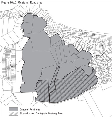
The 'Onetangi Road' area currently extends from Onetangi Road in the south, to
Sea View Road in the north. Sites which front Onetangi Road (shown hatched on the
above figure) have an additional setback requirement as stated in clause 10a.19.7
which requires all new buildings and additions and alterations to existing buildings
to be located at least 100m from the road boundary.
There are a number of submissions to the Plan requesting that the 'Onetangi Road'
area be reconsidered. These submitters are concerned that the area will detract
from the rural character of the land unit.
There is at least one submission which supports the 'Onetangi Road' area and
even seeks extension of this area to accommodate properties located to the south
of Onetangi Road.
The 'Onetangi Road' area of the land unit provides for activities to occur which
are not provided for elsewhere in the Plan (outside of the commercial land units).
It is considered that the 'Onetangi Road' area is a suitable place for these activities
due to the size of the lots within this area and the recognition that the area already
contains some such activities including wineries and visitor accommodation.
It is considered that the scale of the 'Onetangi Road' area is such that the
rural character of the area can be maintained while allowing an opportunity for
'non-rural' activities to establish there. It is also considered that the restricted
discretionary status for any new buildings and external alterations and additions,
along with the additional requirement for the 100m setback for sites fronting onto
Onetangi Road provides adequate discretion for the council to decline consent for
development that is seen to be inappropriate in its scale, form location or colour.
Entertainment facilities, function facilities, restaurant, caf� or other eating
places, tourist complex and wineries are all provided for as discretionary activities
within the 'Onetangi Road' area, but are considered a non-complying activity in
the 'other areas' of the land unit. The scale of new development within the 'Onetangi
Road' area will be individual to each site and the discretionary status of these
activities allows the council to assess each individual application on a case by
case basis and allows all aspects of the proposal to be considered for their suitability.
Some submissions seek that the 'Onetangi Road' area be re-integrated into the
Plan and be subject to the same controls as the 'other area' of the rural 1 land
unit. The panel need to consider the contribution that this area makes to the island
as a whole. The 'Onetangi Road' area provides for a level of development and for
a range of activities which provide for the social, economic and cultural wellbeing
of island residents while maintaining the rural character which defines the land
unit.
4.2.2.3 Isola Estate Development
Several submissions were received in relation to the Isola Estate development.
A number of submitters are concerned with the development which has been granted
permission for the site and seek that the Plan make provisions so that the property
is put in its own land unit and 'ring fenced' to prevent this type of development
from occurring elsewhere on Waiheke.
The Isola Development is located on two properties within the 'Onetangi Road'
area of the Proposed Plan at 74 and 78 Onetangi Road. The two sites measure 40716m
2 and 46803m 2 respectively and resource consent has been
granted for an entertainment facility and large visitor accommodation facility.
Consent was granted to construct an entertainment facility on the site in February
2002 and in June 2006, the Environment Court approved, on appeal, granted for a
52-unit visitor facility. Initially the Council declined the application for the
visitor facility on the grounds that the scale and intensity of the proposal would
result in adverse effects on the environment. In the appeal to the Environment Court,
the development was substantially reduced in floor coverage, site coverage and earthworks
and it was considered by the Environment Court that the development was not incompatible
with and did not harm the integrity of land unit 20.
The Environment Court's decision on this case provided a base for reconsidering
the activities provided for within the rural 1 land unit. In recognition of the
ability of some of the rural 1 land unit to provide for more intensive development
while maintaining the rural character of the land unit between the villages on the
island, the 'Onetangi Road' area was created.
While it is recognised that the scale of the activities permitted for the Isola
Estate development may not be suitable on all sites within the Onetangi Road area,
it is considered that the development controls proposed and the restricted discretionary
status of buildings within the land unit will mean that buildings will be assessed
on their merits on a case by case basis.
Some submissions suggest that the Isola Estate properties would be more suitably
classified if they were included within the commercial 4 (visitor facilities) land
unit. It is recognised that the sites could be considered for inclusion in the commercial
4 land unit as this land unit specifically provides for larger scale visitor facilities
within specific locations on Waiheke. Other sites that are included within the commercial
4 land unit include properties at Onetangi, Palm Beach and Orapiu. The properties
at Orapiu and Palm Beach are established visitor facilities while the sites in Onetangi
are yet to be development.
The Isola Estate development could benefit from being classified within the commercial
4 land unit as this specifically provides for developments such as Isola. However,
it is recognised that as the Isola Estate already has permission for the tourist
activities which they propose to undertake on the property, there may be little
advantage for reclassification of the property from rural 1 to commercial 4. It
is noted that the horticultural activities also carried out on the Isola Estate
property are not provided for as an activity within the commercial 4 land unit and
could make the operation of these activities difficult if the classification of
the site was to change.
It is considered that horticulture and other rural activities undertaken are
key to ensuring the rural character of the rural 1 land unit is maintained and protected
and the 'Onetangi Road' area of the land unit is no exception to this. It has been
recognised through the Plan that these areas can support more intensive non-rural
use of the land than other parts of the land unit as properties in the 'Onetangi
Road' area maintain rural and horticultural activities as the foundation of their
operations.
4.3 Submissions about Rural 2 (western landscape)
Submissions dealt with in this section:
516/9,
560/7,
582/1,
582/2,
582/3,
590/2,
618/64,
618/68,
618/148,
618/149,
619/85,
619/88,
619/97,
619/98,
678/2,
754/97,
754/100,
784/1,
784/2,
859/100,
859/97,
897/3,
903/5,
1093/41,
1093/42,
1093/43,
1172/2,
1250/63,
1250/64,
1285/17,
1285/24,
1285/4,
1286/107,
1286/65,
1286/72,
1287/17,
1287/18,
1287/19,
1287/20,
1287/21,
1287/22,
1287/27,
2670/83,
2670/96,
2670/97,
2721/1,
2767/1,
2767/2,
2772/3,
2878/65,
2878/72,
2878/108,
3061/102,
3169/1,
3169/2,
3521/96,
3729/1,
3729/2,
3729/3,
3729/4,
3729/5,
3729/6,
3729/7,
3729/8,
3729/9,
3729/10,
3729/11,
3729/12
4.3.1 Key issues raised in decisions requested
- Activities within the land unit
4.3.2 Planner's recommended amendments to the Plan
4.3.2.1 Land Units 21 (Te Whau Peninsula) & 22 (Western Landscape) vs. Rural
2 (Western landscape)
It is considered important to discuss the basis for the rural 2 land unit so
that the intentions and characteristics of the land unit can be identified. The
rural 2 (western landscape) land unit in the Proposed Plan has been formed through
a combination of land units 21 (Te Whau Peninsula) and land unit 22 (Western landscape).
Land unit 21 covers a relatively small area of around 200ha of land on the Te
Whau Peninsula and the intention of the land unit was to provide for lower density
residential lifestyles in a rural environment. Land unit 22 covers land at the western
end of Waiheke including Church Bay, Owhanake and Park Point. The land is predominately
pastoral and has a prominent coastal location. The intention of the land unit was
to provide for continued management of the land for rural and conservation purposes
while permitting comprehensive developments.
Combining these two land units is in recognition of similar characteristics of
the areas and from requests from the public in consultation to simplify and reduce
the number of land units. Both areas have a similar rural-residential land use nature,
with productive uses of the land being prominent. The areas all have a prominent
coastal location and large areas of native bush and it is recognised that the areas
are at capacity in terms of subdivision potential.
The rural 2 (western landscape) land unit has been applied in the same locations
as land units 21 and 22 and in addition to this, also applies to Thompsons Point,
which in the Operative Plan contained land unit 1 � coastal cliffs, land unit 4
� wetland systems and land unit 6 � steep pastured slopes. Thompsons Point was included
in the rural 2 land unit for the following reasons:
- The size and location of the land means that the land is unlikely to be used
as a full scale, functioning farm and therefore a classification such as 'productive
land' would not be appropriate
- Providing for rural-residential development would continue the pattern of development
that has occurred on other coastal/rural peninsulas including Te Whau, Church Bay
and Owhanake which is important for maintaining the character and amenity for the
whole island, particularly through revegetation.
In order to describe and identify the improvements that rural 2 will make to
the land units, a comparison between land units 21 and 22 and rural 2 has been undertaken.
This comparison is intended to highlight the differences between the Operative and
Proposed Plans, to give background to why these changes have been made and ultimately
what impact these changes have on the future of the land unit.
Introduction
The description of the land unit 21 (Te Whau Peninsula) in the Operative Plan
states:
Land Unit 21 covers a relatively small area (some 220 ha) of land located at
the southern side of Waiheke Island and is known as Te Whau Peninsula. The land
contains many areas of high amenity and environmental value within the coastal environment.
Prior to this Plan the land was zoned under the Operative 1991 Transitional Waiheke
District Plan to provide for lower density residential lifestyles in a rural environment.
The rules provided for in Land Unit 21 continue to provide those same opportunities.
Special subdivision rules particular to Te Whau Peninsula are contained within the
rules in this Plan and seek to create a pattern of subdivision which is sympathetic
to and protective of the intrinsic values of the natural environment.
Because of its topography, relationship to the waters of the Gulf, soil characteristics
and capabilities and the existence of large areas of high environmental significance
(such as native bush, wetlands and ecosystems), land use activities are limited
by the Plan rules. Those rules are intended to facilitate appropriate coastal management
and the preservation, protection and conservation of the natural environment together
with the maintenance of the rural character of the land unit. In that regard the
subdivision rules for Land Unit 21 specifically seek to limit the number of lots
on Te Whau Peninsula. Permitted activities are restricted to those most likely to
have a minimal impact upon the natural environment.
The topography of the land unit is such that building adjacent to, or in some
places on, ridgelines is likely. In order to ensure that any effects of building
on a ridgeline are no more than minor the land unit rules provide for the assessment
of buildings as a controlled activity with specific ridgeline building assessment
criteria."
The description of the land unit 22 (western landscape) in the Operative Plan
states:
"This land unit is located at the western end of Waiheke Island. The land is
predominantly in pasture with some horticulture and forestry on Hakaimango Point.
There are scattered pockets of remnant native bush and extensive areas of shrubland
in the southern portion of the area. The land unit has an extensive, indented coastline
made up of small, sheltered bays and steep cliffs. Much of the land unit provides
the first significant impression to visitors of the rural landscape character of
Waiheke.
This land unit allows opportunity to develop limited residential and/or visitor
facilities where landscape, environmental, and/or amenity values are secured. The
general purpose of the land unit is to encourage the continued management of the
land for rural and conservation purposes while permitting comprehensive developments,
involving the provision of low density accommodation. This land unit provides an
additional choice as part of a range of living environments on Waiheke Island, whilst
maintaining and enhancing the landscape qualities and amenities of the Island.
Before providing accommodation over and above a single dwelling house a Comprehensive
Rural Development Plan must be submitted by way of a discretionary activity application."
The introductory paragraph of rural 2 (western landscape) in the Proposed Plan
reads as follows:
"This land unit applies to three distinct areas on Waiheke: land at Owhanake,
Church Bay and Park Point; land at Te Whau peninsula; and land at Thompsons Point.
Western landscape is characterised by:
- Its coastal location in that all land within the land unit either adjoins the
coastline or is part of the wider coastal environment.
- Large areas of environmental significance, in particular wetland areas and
areas of native vegetation.
- High natural character and visual amenity due to the large areas of regenerating
native bush, and the coastal cliffs and slopes.
- A rural-residential style of living at Owhanake, Church Bay, Park Point and
Te Whau. Thompsons Point is currently farmed.
- Small scale rural activities, primarily with a horticulture focus.
- The landscape values of the land unit are those of a cultural landscape containing
four key elements:
- The openness and productivity of a rural landscape.
- The natural character of a regenerating landscape.
- The amenity of a low density residential landscape.
- The visual prominence of a coastal landscape.
Overall, western landscape provides for a rural-residential style of living with
high natural character and landscape values."
Like the rural 1 land unit, the clear summarised introductory paragraph of rural
2 (western landscape) identifies the key characteristics of the land unit without
providing unnecessary detail. It is intended that the introductory paragraph describe
the land unit clearly in order to provide certainty to land owners.
Buildings
As for land unit 20, the construction or relocation of a new building and alterations
and additions to the exterior of existing buildings require a controlled resource
consent in land unit 21 and 22 of the Operative Plan, and require a restricted discretionary
resource consent in rural 2 of the Proposed Plan.
A controlled activity status requires that a resource consent be submitted to
the council for the building. The council has the ability to impose conditions on
the application but ultimately the consent must be granted.
A restricted discretionary activity status also requires that a resource consent
be submitted to the council. This application is assessed against the matters which
the council has restricted discretion to which, in the case of the Proposed Plan
are scale, form, colour and location of the proposed building. The council can,
like a controlled activity, impose conditions on the application. The major difference
between controlled and restricted discretionary activities is that if a proposal
does not comply with the council requirements for scale, form, colour and location,
the restricted discretionary application can be declined.
During the formulation of the Plan, the council reached the view that the controlled
activity status was not appropriate for any of the activities identified in the
Plan. In the past, the council has used the controlled activity status in the Isthmus
Plan, the Central Area Plan and in the operative Hauraki Gulf Islands Plan. Considerable
experience in administering these Plans, together with the development of case law,
has led council to the view that, in the main, the use of the controlled activity
status does not provide the council with sufficient discretion to address the potential
adverse effects associated with particular proposals. As discussed above, the council
cannot decline an application for a controlled activity and while the council may
impose reasonable conditions that relate to the matters over which it has reserved
control, it cannot impose conditions which require such significant modification
as to fundamentally alter the proposal. To do so would effectively negate the consent
granted and prevent the activity from taking place. Not all proposals which warrant
assessment through the resource consent process can be adequately mitigated by the
use of conditions. Some proposals need to be declined or substantially modified.
The controlled activity status should be reserved for situations where the council
is confident that every proposal should be consented to and that adverse effects
can be adequately addressed via conditions without substantial modification to the
original proposal. While the controlled activity approach does provide greater certainty
to applicants, this needs to be balanced against the need to ensure good environmental
outcomes.
It is therefore considered that the approach to new and existing buildings in
the rural 2 (western landscape) land unit accurately portrays the intention to manage
the land for rural and conservation purposes and to protect the rural character
and visual amenity of the land unit. The ability to decline consent for any buildings
which are not deemed suitable is a more stringent control than what was applied
in land units 21 and 22 of the Operative Plan.
Activities
Both the Operative and Proposed Plans identify land use activities which are
suitable for inclusion within the land unit. In the Operative Plan, if the activity
is not specifically listed as a permitted, controlled, discretionary or prohibited
activity it is considered to be a permitted activity, provided that it complies
with the development controls. The Proposed Plan however, as described in clause
4.2, takes the position that an activity is considered to be a non-complying activity
if it is not otherwise provided for in the land unit (as a permitted, controlled,
restricted discretionary or discretionary activity) regardless of whether or not
it complies with the development controls.
The approach in the Operative Plan results in activities which have not been
envisaged or considered unsuitable for the land unit, if they comply with the development
controls, being allowed to occur within the land unit as of right. The approach
in the Proposed Plan however, means that activities which have been specifically
excluded from the activity table are required to go through the resource consent
process as a non-complying activity.
There are more activities provided for within clause 10a.20.5 (Rules � activity
table) for rural 2 than in land units 21 and 22 but it is considered that this list
is exhaustive and outlines all activities envisaged to be suitable within the land
unit. The potential activities that could be undertaken as of right through land
units 21 and 22 in the Operative Plan is limited only by compliance with the development
controls.
It is for this reason that it is considered that the Proposed Plan approach,
and the list of activities provided for in rural 2 more accurately represents the
intention and direction for the future of the land unit and enables an assessment
of the suitability of activities against the objectives and policies of the land
unit and the environmental effects, rather than defaulting to a permitted status.
There are a number of activities which have the same activity status in both
land units 21 and 22 and rural 2. These activities are:
Permitted Activities
- Dwelling (one per site)
- Home Occupations
- Homestay
- Horticulture
- Pastoral farming
- Visitor accommodation (for up to 10 people)
The permitted activity status of the above activities is carried through from
the Operative Plan to the Proposed Plan as it is considered that these activities
are desirable and suitable for inclusion within the land unit. Pastoral farming
and horticulture are both productive activities which form the rural, productive
base for the land unit. Dwellings and their associated uses and buildings listed
above, while not considered to be strictly 'productive use' of the land, are considered
to be essential to ensure that the productive land can be managed. The permitted
activity status indicates that these activities, in accordance with the development
controls, are suitable on all sites within rural 2. It is noted that all new buildings
require a resource consent regardless of whether or not the activity is permitted.
Discretionary Activity
- Farm Airstrips or Helipads (covered by clause 13.8 of the Proposed Plan)
A discretionary activity status for the above activity has been maintained in
the Proposed Plan. A discretionary activity requires a resource consent and allows
the council to assess all aspects of the proposal and decline the application if
it is not considered appropriate. A discretionary activity status gives an indication
that the council considers that there may be some cases where these activities are
suitable for inclusion within the land unit, but because of the potential adverse
effects, it is not considered that these activities are suitable in all cases. This
status allows each application to be assessed on a case-by-case basis and on its
own merits.
The following activities have been given a more restrictive status in the Proposed
Plan from that in the Operative Plan. These activities are:
| Activity |
Land Unit 21 status |
Land Unit 22 status |
Rural 2 status |
| Camping Facilities |
Permitted |
Discretionary |
Non-complying |
| Commercial Firewood Harvesting |
Permitted |
Discretionary |
Non-complying |
| Community Facilities |
Discretionary |
Permitted |
Non-complying |
| Comprehensive Rural Development |
Permitted |
Discretionary |
Discretionary (Thompsons Point only) |
|
Multiple dwellings |
Permitted |
Discretionary |
Non-complying |
|
Visitor accommodation for more than 10 people |
Permitted |
Permitted |
Discretionary |
Camping facilities, commercial firewood harvesting, community facilities, and
multiple dwellings have a non-complying activity status as the area is developed
to its potential and vegetation is protected through the comprehensive rural development
plans and therefore the activities have not specifically been provided for in the
activity table in clause 10a.20.5.
Comprehensive rural development and visitor accommodation for more than 10 people
have been restricted, in the proposed plan, to a discretionary activity status.
Comprehensive rural development is addressed in clause 12.9.7 of the Proposed Plan
and is provided for on Thompsons Point only. As discussed in previous hearings,
the provisions for Thompsons Point may not result in the best outcome and further
work needs to undertaken.
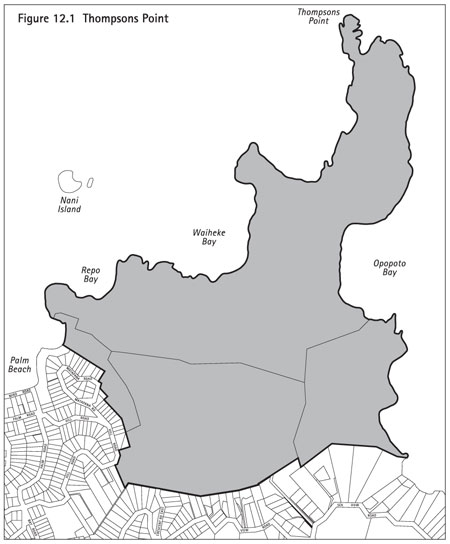
The following area is recognised as Thompsons Point:
Non-complying and discretionary activities are similar in that they have the
same potential for notification however, there are distinct differences in the assessment
of the two types of application. A non-complying resource consent is required to
meet either of the 'gateway tests'. These tests require that an application for
a non-complying activity meet at least one of the following:
" Section 104D(1) of the RMA
(a) the adverse effects of the activity on the environment
(other than any effect to which section
104(3)(b) applies) will be minor; or
(b) the application is for an activity that will not
be contrary to the objectives and policies of�
(i) the relevant plan, if there is a plan but no proposed
plan in respect of the activity; or
(ii) the relevant proposed plan, if there is a proposed
plan but no relevant plan in respect of the activity; or
(iii) both the relevant plan and the relevant proposed
plan, if there is both a plan and a proposed plan in respect of the activity."
Objectives and Policies
The objectives and policies of land unit 21 in the Operative Plan are as follows:
" Objective
To protect, preserve and enhance the special character of the natural environment
of Land Unit 21 particularly the coastal environment, whilst providing opportunities
for land use activities including residential uses, subject to appropriate control
of density, disposition and appearance of buildings.
Policies
- By ensuring buildings and access roads are sited so that they do not detract
from important visual features such as prominent skylines and ridgelines, cliff
tops, coastal headlands, beaches and areas of native bush.
- By ensuring that the design and external appearance of buildings is harmonious
with the natural landscape.
- By seeking the provision of public access to the coastline and the creation
of suitable foreshore reserves at the time of subdivision, in order to enhance
public recreation opportunities.
- By using a variety of resource management techniques to preserve, protect and
enhance native bush, prominent headlands, cliffs, coastal edges, wildlife habitats
and ecological corridors.
- By providing for only one dwelling house per lot.
- By using specific subdivision rules including a median lot size of 3 ha and
a maximum number of lots so that an inappropriate intensity of development is prevented.
- By using Plan rules to minimise disturbance to land forms, trees, bush, streams,
other water systems, including wetlands and the foreshore and coastal environment.
- By controlling the removal of native bush and the nature and extent of earthworks."
The objectives and policies of land unit 22 in the Operative Plan are as follows:
"Objective
To foster the continued use of the land for rural activities in conjunction with
residential uses or visitor facilities in appropriate locations.
Policies
- By ensuring that land with high, actual or potential value for economic productive
rural activities, is not compromised by the inappropriate location of buildings
or other development.
- By securing suitable public access to the coastline, when subdivision takes
place, through appropriate reserve contributions or other arrangements.
- By permitting low intensity residential development, and visitor facilities
which do not compromise the resource management strategy for the Western Waiheke
SMA."
The objectives and policies of rural 2 in the Proposed Plan are as follows:
" Objective
To provide for and protect the rural-residential style of living while avoiding
the adverse effects of activities and buildings on the natural character and landscape
values of the land unit.
Policies
- By providing for rural and residential activities to establish and operate
in the land unit.
- By limiting the range of non-rural and non-residential activities that can
establish within the land unit to avoid adverse effects on the landscape values
and the general amenity of the locality.
- By requiring new sites to be of a size and nature that ensures that small scale
rural activities can occur and which protects the natural character and landscape
values of the land unit.
- By ensuring that the scale, form, colour and location of new buildings will
not have adverse effects on the natural character and landscape values of the land
unit.
- By providing for comprehensive development to occur at Thompsons Point."
It is considered that the objectives and policies outlined for rural 2 (western
landscape) seek to combine the relevant objectives and policies from the Operative
Plan and to simplify and clarify the intended direction for the land unit. The emphasis
on a rural-residential land unit is clearly outlined with the emphasis being that
new buildings be designed to ensure that the natural character and landscape values
of the land unit are not adversely affected.
Development Controls
A large number of the development controls in both land units 21 and 22 and rural
2 are identical as is clear from the table below:
| Development Control |
Land Unit 21 �
Te Whau Peninsula |
Land Unit 22 �
Western landscape |
Rural 2
(western landscape) |
| Height |
8m |
8m |
8m |
| Front yards |
6m |
6m |
6m |
| Side and rear yards |
1.5m |
1.5m |
1.5m |
| Indigenous vegetation removal |
300m 2 |
300m 2 |
300m 2 |
| Earthworks on land with a slope >1 in 6 |
50m 2 |
50m 2 |
50m 2 |
| Earthworks on land with a slope <1 in 6 |
400m 2 |
400m 2 |
400m 2 |
| Protection Yards |
|
|
|
| - coastal (MHWS) |
40m |
40m |
40m |
| - wetland and water bodies |
20m |
20m |
20m |
These controls have been carried over from the Operative Plan into the Proposed
Plan as it is considered that these levels of development are still an appropriate
benchmark for the land unit.
The following table shows the development controls that have been amended in
the rural 2 land unit:
| Development Control |
Land Unit 21 �
Te Whau Peninsula |
Land unit 22 �
western landscape |
Rural 2
(western landscape) |
| Building Coverage |
n/a |
n/a |
500m 2 (max footprint for any one building is 250m
2) |
| Lot Coverage |
500m 2 or 10% (which ever is less) |
500m 2 or 10% (which ever is less) |
n/a |
| Gross dwelling area |
10% of lot <2000m 2 |
10% of lot <2000m 2 |
n/a |
| Noise |
|
|
|
|
� 7am-10pm Mon to Sat, 9am-6pm Sun
|
45dBA |
45dBA |
50dBA |
|
� All other times
|
35dBA |
35dBA |
40dBA |
- Building Coverage/Lot Coverage and Gross dwelling area
In the Proposed Plan, building coverage is defined as:
"Building coverage
means the extent or proportion of the net site area which is covered by buildings
or parts of buildings.
It includes any of the following:
- any parts of the eaves, spouting or bay windows which project more than 1m
measured horizontally from an exterior wall
- overhanging and cantilevered parts of buildings.
It does not include any of the following:
- pergolas with a permanently open roof
- parking below ground level with landscaping above which includes soil of sufficient
depth to allow drainage
- earthen terracing
- satellite dishes
- tanks used for collecting and storing rainwater for reuse on the site.
Maximum building coverage may be defined as an area (such as in m 2)
or as a proportion (such as a percentage) of the net site area depending on the
requirements of the Plan."
The Operative Plan does not refer to building coverage, but instead refers to
Lot Coverage and Gross Dwelling Area:
" Gross Dwelling Area
means the total area of all floors contained within the exterior walls of any
dwelling or visitor facilities excluding stairwells or any private garage located
within those exterior walls."
"Lot Coverage
means that portion of a lot which is covered by buildings or parts of buildings
including overhanging or cantilevered parts of buildings (including any part of
the eaves and/or spouting or bay windows projecting more than 1m measured horizontally,
from the exterior wall). In the case of multiple dwellings, papakainga and buildings
approved as part of a Comprehensive Rural Development in Land Unit 22, lot coverage
refers to the coverage associated with each approved dwelling.
The following shall not be included in Lot Coverage:-
- Pergolas;
- Underground car parking with landscaping above.
- Earthen terracing with landscaping above of sufficient depth to allow drainage;
- Satellite dishes."
Effectively, lot coverage and building coverage are the same thing. The Operative
Plan provisions provide an either/or situation where coverage can be 10% of the
site or 500m 2, whichever is less. The Proposed Plan applies a different
approach to coverage in that it allows all sites to have a maximum building coverage
of 500m 2 but it restricts the footprint of a single building to 250m
2.
It is considered that the Proposed Plan approach to building coverage is less
restrictive to smaller sites (under 5000m 2) as it allows greater development
(up to 500m 2) than the previously allowed 10% of the site. For larger
sites (5000m 2 and over) the Proposed Plan is more restrictive because
although it allows the same total coverage, individual buildings are restricted
to a maximum of 250m 2.
Gross dwelling area requirements have been removed from the Proposed Plan. It
is considered that the development controls, along with the restricted discretionary
status for new buildings and additions and alterations to the exterior of existing
buildings on the bulk, location and colour of buildings are sufficient controls
to ensure that buildings within rural 2 meet the objectives and policies of the
land unit.
Noise
Noise provisions are another development control which have changed from what
is contained in land unit 20 in the Operative Plan. As detailed in the table above
noise levels for Monday to Saturday 7am till 10pm and Sunday 10am till 6pm are now
50dBA in the Proposed Plan (up from 45dBA in the Operative Plan) and noise at all
other times is now 40dBA (up from 35dBA in the Operative Plan).
The increase in noise levels has been made to successfully achieve a balance
between managing noise arising from activities so that adverse effects are avoided
and mitigated and enabling the sustainable growth of the economy. Council recognises
that the noise levels imposed, including those at night time, whilst taking into
account the low background noise levels found in many parts of the islands must
enable reasonable residential and commercial activities to occur, especially in
areas of higher population and therefore the noise control thresholds have been
raised.
Subdivision
Subdivision matters are addressed in detail in the hearing report for Part 12
� subdivision. Land Unit 21 (Te Whau Peninsula) in the Operative Plan has a specific
clause (clause 8.7.3) which outlines the subdivision provisions for the land unit
as follows:
"A. The median size of the total number of lots proposed shall be not less than
3ha.
B. A maximum of 10% of the total number of lots to be created shall be permitted
to be between 1.0 and 1.5 ha in area.
C. The minimum size for any lot shall be 1 (one) hectare.
D. The maximum number of lots permitted in Land Unit 21 shall be 35, provided
that this will be increased up to a maximum of 55 lots at a ratio of 1 additional
lot per 2 ha of open space where such open space:
(a) Is vested in Council as a reserve providing access between any road and
esplanade reserves; and/or
(b) Protects and preserves in perpetuity significant landscape features or areas
of native bush or shrubland or sites of ecological significance or habitats by
means of suitable protective instruments such as encumbrances, covenants or consent
notices provided that:
i) Such land is over and above that required for esplanade reserves, local
purpose (access) reserves, roads and land set aside for public utilities;
ii) Is appropriate for accessways for protection of the landscape features
or areas of native bush or shrubland sites of ecological significance or habitats;
and
iii) An appropriate protective instrument is prepared by the City Solicitors
at the expense of the applicant; and
iv) The objectives and policies for the land unit and the strategic management
area are given effect to."
Land Unit 22 (western landscape) of the Operative Plan also has a specific clause
(clause 8.7.4) which outlines the subdivision provisions for the land unit as follows:
"Application for a subdivision in Land Unit 22 shall only be considered in the
following circumstances:
A. Minimum Area
Where the minimum area of 25 ha in Table 8.2 is provided for,
Or
B. Comprehensive Rural Development
Where a discretionary application for subdivision is sought in conjunction with
a discretionary application for a Comprehensive Rural Development under Rule 6.22.4.3.B(c)
and complies with the following standards:
(a) The subdivision shall provide for lots at a ratio of one lot per 5 ha of
gross land area of the site subject to a Comprehensive Rural Development application
unless increased in terms of rule 8.7.4 C. and
(b) No lot created shall have a minimum area of less than 1.5 hectare, other
than those lots created for the purpose of reserves, or public accessways, and
(c) Any such subdivision shall meet the assessment criteria set out in 8.6.1.
C. Bonus Density Provisions For Land Unit 22
Application may be made for a subdivision which provides for lots at a density
greater than that specified in terms of Rule 8.7.4.B(a) up to a maximum density
of 1 lot per 3.5 ha of gross land area of the site. For each additional lot which
increases the lot ratio below that provided for in Rule 8.7.4.B(a) an additional
2 hectares of public open space, reserve, protected area or protected significant
natural feature shall be provided. Any application shall be considered in terms
of the following criteria:
i) Whether the proposed subdivision is likely to minimise the impact of buildings
in the rural landscape. In that regard discretely located clusters rather than
a widely dispersed pattern of buildings is considered more likely to meet this
criteria, and
ii) Whether or not the subdivision is likely to lead to buildings being located
in a manner which will detract from the character of the coastal landscape or coastal
environment, and
iii) Whether the proposed subdivision facilitates the protection of soils of
high actual or potential productivity or whether it is likely to lead to cumulative
impacts, permanently or significantly affecting such high actual or potential productivity,
and
iv) The extent of protection proposed as part of the subdivision application
and the nature and extent of the protective legal instruments, and
v) Whether the proposal is consistent with the objectives and policies of the
Western Waiheke SMA resource management strategy."
Rural 2 (western landscape) in the Proposed Plan has simplified the subdivision
provisions to ensure clarity for landowners. It is important to note the resource
management strategy outlined in the Proposed Plan states:
"As the land at Owhanake, Church Bay, Park Point and Te Whau is largely developed
to capacity, the focus of the resource management strategy for these areas is to
provide for the continued operation of rural-residential activities and maintain
the natural character and landscape values of the land unit.
As Thompsons Point has not yet been developed to capacity, comprehensive development
is provided for in this area. Comprehensive development will provide for a rural-residential
style of living in the context of a landscape enhanced by regenerating vegetation..."
"The general amenity of the land unit is protected by limiting the activities
provided for to those of a residential or rural nature and thereby avoiding activities
that might generate significant amounts of noise or traffic."
A number of submissions were addressed in the hearings report for subdivision
relating to the minimum site size for the land unit. The Proposed Plan currently
requires a minimum site size of 25ha. It is considered by the reporting planner
in the subdivision report and in expert advice from Mr John Hudson (in his landscape
assessment report which is included as Appendix 3) that the minimum site size could
be reduced from 25ha while still retaining the intrinsic values of the area.
The following recommendation is made by Mr Hudson in his report:
"Having reviewed the landscape character throughout Western Waiheke, and having
assessed it in terms of the key elements identified as intrinsic values of the area,
it is my opinion that the density could be reduced from 25ha while still retaining
these characteristics. I recommend that a minimum lot size of 5ha is appropriate
for Western Waiheke, when the landscape constraints are considered. This minimum
foresees the possible potential subdivision that could occur with neighbours combining
their lots. While a total of 20 additional lots would not be inappropriate in terms
of landscape effects, additional subdivision below the 5ha minimum is not supported
as part of this assessment. The strength of the objectives and policies will be
critical in limiting subdivision below the minimum lot size.
I also recommend that there be no provision for bonus density through Significant
Natural Features, as these features have already been used to justify the extra
density to date and reusing them would amount to double dipping.
There will be a need for significant planting if some of the more open lots are
subdivided, and this should be achieved through the rules 12.9.7.3.(2c) "Standards
and Terms". This particularly relates to Lot 1 DP 154784 of 41 ha, which is currently
open pasture and if subdivided, would need substantial revegetation to integrate
the houses into the landscape.
Te Whau also falls within the Rural 2 provisions. In terms of landscape effects,
the single existing lot over 10ha (Lot 21 DP 160901) has the potential for subdivision
under these recommended provisions. This subdivision has the potential to be acceptable
in terms of landscape effects provided a well integrated house site with minimal
disturbance to existing vegetation can be found."
The subdivision hearings report has recommended that the minimum site size for
the land unit be reduced to 5ha as it is considered that this site size is considered
to be consistent with other sites classified with other sites classified as rural
2 and would still retain the desired landscape values for rural 1 as outlined in
the objectives and policies.
Conclusion
In response to community feedback, the rural 2 (western landscape) land unit
has been simplified to ensure clarity to landowners and the provisions relating
to buildings, activities and development controls have been formulated to provide
for the rural-residential style of living while protecting the landscape character
and natural features of the land unit. Recommendation has been made to amend the
subdivision provisions to reduce the minimum site size from 25ha to 5ha. This recommendation
has been made in order to ensure consistency in the classification of the rural
2 land unit and to better reflect the existing development pattern and the objectives
and policies of the land unit.
In general, the controls in place in the Proposed Plan under the
rural 2 land unit are more restrictive on the types of development and the built
form for the land unit than those in land units 21 and 22 in the Operative Plan.
It is also considered that the subdivision controls more clearly define the direction
for the land unit, especially through the recommendation to reduce the minimum site
size.
4.3.2.2 Activities in the land unit
There are a number of submissions which seek amendments to those activities provided
for within the land unit. A summary of submissions requesting changes to the activity
table at 10a.20.5 is as follows:
- Retain pastoral farming as a permitted activity but amend the definition to
include farm buildings
- Restricted discretionary activity status for the construction and relocation
of buildings to a controlled activity status
- Inclusion of the following activities as restricted discretionary activities:
- caf�s and restaurants
- outdoor recreation/adventure activities
- residential uses
- wineries
- farm buildings
- art galleries and museums
- care centres
- educational facilities
- function facilities
- integrated visitor development
- open air markets
- rural property management plans
- tourist complexes
- wineries
- minor dwellings
- clustered residential developments
- disposal of treated wastewater
- churches, places of worship and church towers
- windmills
- open air markets
- Helipads as a discretionary activity
- Retain horticulture as a permitted activity
- Wineries as a controlled activity
- Visitor accommodation for up to 10 people as a discretionary activity
- Farm buildings as a controlled activity
- Grape growing as a permitted activity
- Removal of the activity table in 10a.20.5 and replace it with the current provisions
As discussed earlier in the report the Operative and Proposed Plans have different
ways to address activities that are not specifically provided for within the individual
land unit. In the Operative Plan, if the activity is not specifically listed as
a permitted, controlled, discretionary or prohibited activity it is considered to
be a permitted activity, provided that it complies with the development controls.
The Proposed Plan however, as described in clause 4.2, takes the position that an
activity is considered to be a non-complying activity if it is not otherwise provided
for in the land unit (as a permitted, controlled, restricted discretionary or discretionary
activity) regardless of whether or not it complies with the development controls.
Therefore although there are more activities provided for within clause 10a.20.5
(Rules � activity table) for rural 2 than in the Operative Plan, this list is more
exhaustive and outlines all activities envisaged as suitable within the land unit.
The potential activities that could be undertaken as of right through land units
21 and 22 in the Operative Plan is limited only by compliance with the development
controls.
It is for this reason that it is considered that the Proposed Plan approach,
and the list of activities provided for in rural 2 more accurately represents the
intention and direction for the future of the land unit and enables an assessment
of the suitability of activities against the objectives and policies of the land
unit and the environmental effects, rather than being permitted.
The rural-residential style of living in the land unit is achieved by limiting
the non-rural and non-residential activities that can establish within the land
unit. The activities that have been included within the activity table for the land
unit have been restricted to rural productive activities including pastoral farming
and horticulture and residential activities including dwellings and visitor accommodation.
Activities which have not been listed in the activity table have been excluded as
it is not considered that other activities would contribute to the rural-residential
style of the land unit. The Panel will need to consider whether any of the suggested
activities would be appropriate for inclusion in the activity table.
4.4 Submissions requesting reclassification of specific properties
Submissions dealt with in this section:
83/2,
520/4,
1119/1,
1287/16,
2772/3
4.4.1 Summary of decisions requested
Submission
83/2 seeks
to reclassify the land on the western side of Huruhi Bay from rural 2 (western landscape)
to rural 1 (rural amenity).
Submission
520/4 seeks
to reclassify land around Owhanake within DP's 183454, 183455 and 183456 north of
Delamore Drive from rural 2 (western landscape) to rural 1 (rural amenity).
Submission
1119/1
seeks to reclassify the island chain off Te Whau Bay (legally identified as NA
747/349
Island Deposited Plan 1721) from the conservation land unit to rural 2 (western
landscape)
Submission
1287/16 seeks to reclassify 120ha at 306 Sea View Road, Thompsons Point, from
Landform 1(coastal cliffs and slopes), Landform 4 (wetland systems) and Rural 2
(western landscapes) to Rural 2A, Rural 2B and Island Residential.
Submission
2772/3
supports the amalgamation of the other current land unit into rural 2 (western landscape).
4.4.2 Planner's recommended amendments to the Plan
4.4.2.1 Submission
83/2 � western
side of Huruhi Bay
The submission seeks that properties on the eastern side of the Church Bay ridge,
running down to Huruhi Bay be reclassified from rural 2 (western landscape) to rural
1 (rural amenity).
The main concern that the submitter outlines is that the properties are significantly
larger than the average lot size in rural 2, however they are less than the 25ha
minimum site size required for subdivision.
It is noted that subpart
83/1 of
the submission seeks that the minimum site size of the land unit be reduced from
25ha to meet the provisions of the Thompsons Point (comprehensive development) with
an average of 7.5ha and a minimum area of 4ha.
As noted in the discussion on subdivision above, it has been recommended in the
hearings report for Part 12 - subdivision that the minimum site size for rural 2
be reduced from 25ha to 5ha. With this recommendation in mind, and the specific
concern of the submitter over the minimum site size for the Rural 2 land unit, it
is considered that the recommended changes to the subdivision controls will meet
the submitters request and therefore, there is no further need to reclassify the
property.
It is therefore recommended that the submission be rejected.
4.4.2.2 Submission
520/4* �
land around Owhanake
There are a number of properties covered in this submission, which the submitter
seeks to be reclassified from rural 2 to rural 1. The submitter in this case has
similar concerns, to that raised in section 4.4.2.1 above, regarding the minimum
site size of 25ha for rural 2.
The hearings report for Part 12 � subdivision recommends that the minimum site
size for the rural 2 (western landscape) land unit be reduced from 25ha to 5ha as
it is recognised that this minimum site size maintains the landscape values and
the meets the objectives, policies and resource management strategy for the land
unit.
It is considered that the recommendation to reduce the minimum site size of the
land unit to 5ha addresses the submitters concerns and it is not considered necessary
therefore to make any additional changes to the Plan, by way of reclassification.
It is therefore recommended that the submission be rejected.
*It is noted that this submission has been withdrawn however, there is a further
submission on this subject which is still valid.
4.4.2.3 Submission
1119/1
� Te Whau Island
The submission raises concern with the restrictions placed on the property through
the conservation classification of the land and seeks that the land be reclassified
as rural 2 (western landscape).
The land referred to in the submission is a small island offshore from Te Whau
Bay. The island is covered by a number of heritage features including 2 archaeological
sites (and the surrounds of these sites) and a geological site.
The two archaeological sites are category A and the rules require that
new buildings obtain a discretionary resource consent. The geological site is category
B which also require a discretionary resource consent to be obtained for new buildings.
As discussed in the hearings report for the conservation land unit, the land
unit as notified did not adequately recognise the need for recreational activities
on land not owned by DOC. It was considered in this report that some passive recreation
activities could be established in the land unit and operate simultaneously with
conservation activities without compromising the conservation values of the islands.
As a result of this, the following activities were recommended to be included
in the activity table for the land unit:
- Walking tracks
- Observation areas, viewing platforms and related structures
- Park furniture
- Accessory buildings
While it is recognised that no provision has been made for dwellings within the
conservation land unit, it is considered that the above additions do go further
to recognise the needs of private owners of land within the conservation land unit.
The conservation land unit covers
a number of small islands, both publicly and privately owned. One of the key characteristics
of the land unit is the high scenic and conservation values and the key function
of the land unit is conservation management. The rural 2 land unit on the other
hand has a rural character and the intention of the land unit is to provide for
a rural-residential style of living.
With this in mind it is considered
that the island subject to this submission has been adequately classified within
the conservation land unit and it is recognised that the changes recommended in
the hearings report for the conservation land unit will provide for more use of
conservation land for private land owners.
It is therefore recommended that
the submission be rejected.
4.4.2.4 Submission
1287/16 � 306 Sea View Road, Thompsons Point
The submission seeks that the land at 306 Sea View Road be reclassified from
landform 1 (coastal cliffs and slopes), landform 2 (dune systems and sand flats),
landform 4 (wetland systems) and rural 2 (western landscape) to rural 2a, rural
2b and island residential 1.
The property subject to the submission is made up of two titles and covers the
largest area of Thompsons Point at around 120ha. In the Operative Plan, the property
contained land unit 1 (coastal cliffs), land unit 2 (dune systems and sand flats),
land unit 4 (wetland systems) and land unit 6 (steep pastured slopes). These land
units have been rolled over with the exception that the land classified as land
unit 6 has been classified as rural 2 (western landscape) in the Proposed Plan.
The submission seeks that an area of island residential 1 (traditional residential)
be provided for. The area marked on the Plan attached to the submission indicates
an area which currently backs onto existing island residential 2 (bush residential)
land. It is considered that this area could be suitable for more intensive residential
development, however more information is required from the submitter relating to
proposed access for the new lots to be created.
The submission also seeks that the landform 1 (coastal cliffs and slopes), landform
2 (dune systems) and landform4 (wetland systems) be replaced, along with the rest
of the property which is currently classified as rural 2 (western landscape) to
rural 2A and 2B classification.
The submission suggests that a rural 2A classification would provide for residential
lots at 1 dwelling per 3.5ha while rural 2B would provide for 1 dwelling per 5ha.
As discussed in the subdivision section of this report above, the recommendation
has been made to the hearings panel that the minimum site size for subdivision in
rural 2 be reduced from 25ha to 5ha. Comprehensive development has been provided
for on Thompsons Point and this allows for a minimum site size of 4ha with an average
site size of 7.5ha.
The plan attached to the submission does not identify what area of the site is
proposed as rural 2A or rural 2B however the submitter has appeared in a previous
hearing and provided some possible development proposals for the site.
As recommended in previous reports and advised in the hearings, it is considered
that neither the Operative or the Proposed Plan provisions would achieve the best
outcomes on the site. However, the landowner's proposal may not be the most appropriate
either. Overall, it will require further discussion with the landowner (preferable
all the landowners on Thompsons Point) in order to address it more appropriately
in the Plan.
4.4.2.5 Submission
2772/3
� support for Rural 2
Submission
2772/3
is accepted to the extent that it supports the amalgamation of land units 21 and
22 from the Operative Plan into rural 2 in the Proposed Plan.
| Planner's recommendations about submissions seeking reclassification
of specific properties
That submission
2772/3
be accepted with no amendments to the Plan required to give effect to this submission.
That submissions
83/2,
520/4,
1127/2,
1119/1,
1233/2,
3398/6,
3521/161 be rejected.
No recommendation can be made at this time in relation to submission
1287/16.
|
5.0 Conclusion
This report has summarised for the hearing panel the key issues raised by the
decisions requested in submissions lodged regarding Rural 1 (rural amenity) and
land unit - Rural 2 (western landscape) of the Proposed Auckland City District Plan:
Hauraki Gulf Islands Section 2006.
The report recommends how the Plan should be modified in response to submissions.
These recommendations are made prior to the hearing of submissions and therefore
without the benefit of evidence which may be presented at that time. At this stage
before the hearing, it is recommended that this part of the Plan be approved, with
amendments (as outlined in appendix 3), for the reasons outlined in this
report.
| |
Name and title of signatories |
Signature |
| Author |
Deborah Kissick, Reporting Planner |
|
| Reviewer |
Megan Tyler, Manager: Islands
|
|
| Approver |
Penny Pirrit, Manager: City Planning |
|
Appendix 1
List of submissions and further submissions
Appendix 2
Summary of decisions requested
Appendix 3
Landscape Report, Mr John Hudson, Landscape Architect