Plans, policies and reports
District Plan Hauraki Gulf Islands Section - Proposed 2006
(Notified version 2006)
Street index |
Planning maps |
Text |
Appendices |
Annexures |
Section 32 material |
Plan modifications |
Help |
Notified - Home |
Decision - Home
Appendix 1a- Schedule of archaeological sites - inner islands
1.0 Introduction
2.0 Key to reasons for scheduling archaeological sites
3.0 Notes and disclaimers
4.0 Diagrams of scheduled archaeological sites
5.0 Diagrams of grouped surrounds for scheduled archaeological sites
6.0 Scheduled archaeological sites on Browns Island, Motuihe and Motutapu
1.0 Introduction
This appendix contains key information about scheduled
archaeological sites. In particular it identifies:
-
The location of scheduled sites, including
the site surrounds.
-
The category (A or B) applying to each
site.
-
The reasons for scheduling each site.
Scheduled archaeological sites are shown on the planning
maps. Part 7 - Heritage contains the objectives, policies and rules
applying to such sites.
Section 4.0 of this appendix contains diagrams of the
scheduled sites. Some sites have been grouped within a common site surrounds.
Those site surrounds diagrams are contained in section 5.0.
The diagrams in sections 4.0 and 5.0 are ordered according
to their planning map reference number.
Section 6.0 lists scheduled sites on Browns Island, Motuihe and Motutapu.
2.0 Key to reasons
for scheduling archaeological sites
Each diagram includes a record of the reasons for scheduling
the particular site. The reasons relate to the criteria identified in
appendix 4 - Criteria for scheduling heritage items. The list of reasons
for scheduling archaeological sites are as follows:
| Letter |
Reason |
| A/a |
Gaining information and knowledge
archaeologically |
| B/b |
Representative example |
| C/c |
Diversity |
| D/d |
Rarity |
| E/e |
Group |
| F/f |
Visual contribution to landscape |
| G/g |
Setting |
| H/h |
Intactness |
| I/i |
Education and interpretation value |
| J/j |
Community association with or
public esteem for |
| K/k |
Early period |
| L/l |
People |
| M/m |
Event |
| N/n |
Archaeological / science history |
| O/o |
Architectural value |
| P/p |
Technical accomplishment or value |
The reasons are identified on each diagram in the following
manner:
-
A capital letter (eg A, D, O) means that
the scheduled site scored significantly (ie above the median) for this
criteria.
-
A lower case letter (eg a, d, o)
means that the scheduled site has scored moderately (ie below the median)
for this criteria.
-
Where a letter is omitted, the scheduled
site has not scored against this criteria.
Further information about the criteria for scheduling
archaeological sites is contained in appendix 4.
3.0 Notes and
disclaimers
The New Zealand Historic Places Trust
This appendix of archaeological sites scheduled by the
council is not the same as those of the New Zealand Historic Places
Trust listed in The Register of Historic Places, Historic Areas, Wahi
Tapu and Wahi Tapu Areas. It is a separate but parallel protection process.
The scheduled sites in this appendix are in response to the requirements
of the RMA. The Register of Historic Places, Historic Areas, Wahi Tapu
and Wahi Tapu Areas is in response to the Historic Places Act 1993.
Since a heritage place may appear in either or both lists, care should
be taken to find out and fulfil any obligations arising from the place
being included in either or both lists. All archaeological sites in
New Zealand are protected by the New Zealand Historic Places Trust,
whether listed or not.
The New Zealand Archaeological Association
All known archaeological sites in New Zealand are recorded
by a New Zealand Archaeological Association (NZAA) file keeper. The
NZAA is not a regulatory body. Protection is given to all archaeological
sites in New Zealand whether recorded or not recorded, by the New Zealand
Historic Places Trust as required by the Historic Places Act 1993.
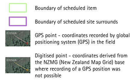
Disclaimer for all diagrams in appendix 1a
The scheduled sites are defined by latitude and longitude
coordinates. The polygon, shown on the diagrams as a green outline,
is defined by the coordinates provided and forms the definitive identity
and location of the scheduled site, with all other identifying information
(address etc) being supplementary
Some diagrams may include parts of a site extending
below mean high water springs (MHWS). Areas below MHWS fall within the
jurisdiction of the Auckland Regional Council, and are therefore outside
the jurisdiction of this Plan. Any areas below MHWS are indicative and
shown for information purposes only.
4.0 Diagrams of
scheduled archaeological sites
Diagrams legend
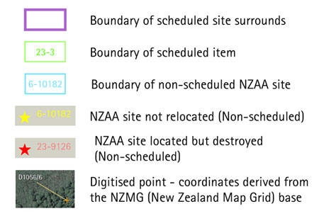
5.0 Diagrams of
grouped surrounds for scheduled archaeological sites
Diagrams legend
6.0 Scheduled
archaeological sites on Browns Island, Motuihe and Motutapu
This table lists sites which were scheduled in the previous
district plan and which have been carried over without further detailed
evaluation. These sites are also identified on the planning maps.
Part 7 - Heritage contains the objectives, policies and rules that apply
to scheduled archaeological sites.
| Planning
map ref |
Item |
Island |
Category
1 |
Management
group type |
| 30-59 |
Pa (central cone) |
Browns Island (Motukorea) |
B |
A |
| 30-60 |
Pa (hill) |
Browns Island (Motukorea) |
B |
B |
| 30-61 |
Archaic midden and stoneworking
area |
Browns Island (Motukorea) |
B |
E |
| 30-62 |
Stone work |
Browns Island (Motukorea) |
B |
C |
| 31-9 |
Midden / stoneworking floor |
Motutapu |
B |
E |
| 31-10 |
Midden / stoneworking floor |
Motutapu |
B |
E |
| 31-11 |
Headland Pa |
Motutapu |
B |
A |
| 31-12 |
Pits, terraces, midden, burials,
agriculture, postholes and drains |
Motutapu |
B |
A |
| 31-13 |
Headland Pa |
Motutapu |
B |
A |
| 31-14 |
Pits, terraces, midden |
Motutapu |
B |
B |
| 31-15 |
Pits, terraces, midden |
Motutapu |
B |
A |
| 31-16 |
Pits, terraces, midden, graves |
Motutapu |
B |
B |
| 31-17 |
Agricultural area, hangi |
Motutapu |
B |
E |
| 31-18 |
Pits, terraces, midden |
Motutapu |
B |
B |
| 31-19 |
Graves (7), quarantine cemetery |
Motuihe |
B |
D |
| 31-20 |
Graves (2), Reid graves |
Motutapu |
B |
D |
Note:
-
A category B status has been allocated
to all these items.