District Plan Hauraki Gulf Islands Section - Proposed 2006
(Notified version 2006)
Street index |
Planning maps |
Text |
Appendices |
Annexures |
Section 32 material |
Plan modifications |
Help |
Notified - Home |
Decision - Home
Part 10b Settlement areas: objectives, policies and activity tables
10b.1 Introduction
10b.2 Resource management issues
10b.3 Objectives and policies for all settlement areas
10b.4 Resource management strategy
10b.5 Objectives and policies for Tryphena settlement area
10b.6 Objectives and policies for Medlands settlement area
10b.7 Objectives and policies for Claris settlement area
10b.8 Objectives and policies for Okupu settlement area
10b.9 Objectives and policies for Whangaparapara settlement area
10b.10 Objectives and policies for Awana settlement area
10b.11 Objectives and policies for Okiwi settlement area
10b.12 Objectives and policies for Port Fitzroy settlement area
10b.13 Objectives and policies for Aotea settlement area
10b.14 Introduction to activity tables
10b.15 Residential amenity areas
10b.16 Local retailing areas
10b.17 Headland protection area
10b.18 Visitor accommodation area
10b.19 Reserve, dune, coastal margin and wetland conservation areas
10b.20 Claris light industry area
10b.21 Claris airport area
10b.22 Mulberry Grove School, and Okiwi School and Domain areas
10b.23 Medlands quarry area
10b.24 Relationship with rules in other parts of the Plan
10b.1 Introduction
This part of the Plan contains the objectives, policies
and activity tables applying to land on Great Barrier identified on
the planning maps as being in a settlement area.
This part outlines a resource management method for
enabling human activities to occur within settlements, while safeguarding
the important natural environment of Great Barrier.
The nine settlement areas are:
- Tryphena
- Medlands
- Claris
- Okupu
- Whangaparapara
- Awana
- Okiwi
- Port Fitzroy
- Aotea (encompassing Motairehe and Kaoa).
These areas have historically been areas of settlement
and they are important centres of community for the people of Great
Barrier. Some of these settlements have the capability to grow into
the future, while others are recognised as needing to be contained within
existing areas due to the fragile or sensitive nature of the surrounding
environment.
Each settlement area has a settlement plan which further
divides each settlement into sub-areas. As set out in part 3 - Strategic
management areas, part of the resource management strategy for Great
Barrier has been to establish settlement plans to promote growth and
development in and around the settlement areas on Great Barrier.
10b.2 Resource
management issues
The significant resource management issues which need
to be addressed in the Plan are:
- How to manage and facilitate growth within
the existing settlement areas on Great Barrier without compromising
the natural environment.
- How to encourage activities within
settlement areas that enable the community to provide for their social,
cultural and economic wellbeing.
- How to ensure that new activities
within settlement areas are located so that they do not adversely affect
other land uses.
10b.3 Objectives
and policies for all settlement areas
Clauses 10b.3.1-10b.3.2 sets out the overall objectives
and policies which apply to all settlement areas. Clauses 10b.5 -10b.13
set out objectives and policies for each settlement area.
10b.3.1 Objective
To provide for limited growth in existing settlements
while protecting the natural environment.
Policies
- By identifying areas in which additional
subdivision can occur within the Okiwi and Claris settlement areas.
- By identifying boundaries that limit
the expansion of the settlements into surrounding areas in order to
avoid the spread of development into sensitive natural areas.
10b.3.2 Objective
To facilitate appropriate development in suitable places
throughout the settlement areas, based on the type of existing activities.
Policies
- By identifying areas within the settlement
areas that have common characteristics, so that these activities can
support each other and limit adverse effects on more sensitive activities.
- By ensuring that development maintains
or enhances the high landscape and ecological values of Great Barrier.
- By limiting adverse effects of activities
and encouraging or requiring low impact design methods including:
- Onsite management and re-use of stormwater
and wastewater.
- Noise insulation.
- Minimising impermeable surfaces.
- Using renewable energy sources.
- Maintaining or increasing indigenous
biodiversity.
- Mitigation of visual impacts of
development.
10b.4 Resource
management strategy
Each settlement area has a settlement plan which focuses
on existing areas where development has occurred. The settlement plans
have been developed to enable an integrated approach to resource management
for the settlement areas. They recognise issues around reverse sensitivity
by locating similar activities in the same locations, and enable a framework
for sustainable management for activities on the island. Where growth
is to occur, it is encouraged within or around the settlement areas
rather than compromising the landscape values of outlying areas.
The framework recognises the need to enable the community
of Great Barrier to undertake activities that will assist with sustaining
and maintaining an economy on the island, while also recognising that
the key asset to the island is its natural environment and unique position
in the gulf. The settlement plans recognise that an element of the islands
is the human environment, and that people and the community play an
important part in giving the island its unique character.
Where appropriate, each settlement area has identified
sub-areas within where specific activities can take place. There is
an overall objective, and policies for each settlement area. Each sub-area
also has its own set of objectives and policies that relate to the particular
characteristics of that area. Subdivision is also controlled based on
the particular characteristics of the surrounding land through
part
12 - Subdivision.
10b.5 Objectives
and policies for Tryphena settlement area
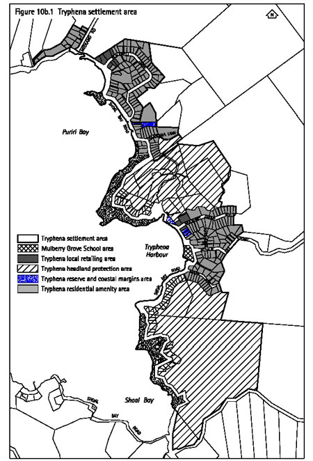
10b.5.1 Introduction
The Tryphena settlement area contains the largest existing
population centre on Great Barrier. Within it, existing settlement is
concentrated in the two areas of Mulberry Grove and Gooseberry Flat.
Each of these areas contain a small local retail centre providing services
to the residents and the visitor industry. Tryphena Wharf to the southwest
of the settlement area is a principal entry point to the island for
visitors and freight as well as serving local fishing boats.
The settlement area is characterised by:
- A small historical lot pattern accommodating
small scale development.
- Larger bush covered residential lots.
- Two separate areas that form the Tryphena
local retailing area.
- Proximity to the main wharf entry point
for Great Barrier.
- A coastal margin dominated by pohutukawa
forest.
The existing settlements are centred on the lower slopes
and coastal margins of the inner bays. The upper catchment of Tryphena
Harbour inland of the settlement area is forested, containing significant
stands of remnant forest and extensive areas of regenerating bush. There
are few areas of relatively flat or gently sloping land, the most extensive
being in the Tryphena valley north of the settlement area. Pockets of
remnant forest are also located on this headland, in the lower valleys
of Shoal Bay, and in the valley inland of Gooseberry Flat.
Within the intensively settled areas on the lower slopes,
ground water levels tend to be high. There are also a number of smaller
creeks which are prone to flooding. Water quality levels at Pah Beach
can often be adversely affected during rainy periods. The lower reaches
of the Tryphena Stream are an important brown teal habitat while the
Shoal Bay Stream valley is an important lizard habitat with five species
(including the Great Barrier skink) found in the area.
The future of Tryphena will be to continue to provide
the main sea access to Great Barrier, with a mix of commercial, residential
and visitor activities, nestled into the bush environment in the five
areas identified in the settlement plan.
The Tryphena settlement area has been divided into the
following sub-areas:
- residential amenity area
- local retailing area
- headland protection area
- reserve and coastal margin area
- Mulberry Grove School area.
The location of each of these is shown on figure 10b.1: Tryphena settlement area.
The objectives and policies for the Tryphena settlement
area are set out below. The objectives and policies for all settlements
areas contained in clause 10b.3 also apply.
10b.5.2 Objective
- Tryphena settlement area
To allow for continued development of existing sites
in Tryphena in a way that does not compromise the bush covered character
of the settlement.
Policies
- By limiting the adverse visual effects
of buildings through standards on colour, and ensuring that the natural
landscape remains the dominant element in terms of visual amenity.
- By ensuring that development is
subject to bulk, coverage and location standards, and where these standards
are exceeded, that the adverse effects are avoided or mitigated.
- By limiting removal of indigenous
vegetation in order that drainage, stormwater and sedimentation effects
are reduced or avoided and landscape values are maintained.
- By protecting riparian areas around
streams and where activities affect riparian areas, requiring planting
to maintain or enhance water quality.
- By controlling the scale and form
of buildings within the headland protection areas and reserves and coastal
margin areas, to ensure that buildings integrate with the landscape.
10b.5.3 Objective
- Tryphena residential amenity area
To maintain the low impact, bush covered, and residential
character of the Tryphena residential amenity area.
Policies
- By limiting the footprint of buildings
to ensure that the size of buildings is of a residential scale.
- By providing for home occupations
and homestays as a permitted activity to enable an economic use of appropriate
scale for residential sites.
- By limiting activities that are
likely to have a detrimental effect on residential amenity due to effects
such as noise or traffic.
10b.5.4 Objective
- Tryphena local retailing area
To concentrate good quality visitor and local retail
development and activities within the local retailing area.
Policies
- By requiring new development in the local
retailing area to be well designed and have a high standard of amenity
and character.
- By ensuring that new development
in the local retailing area blends in with, rather than dominates, existing
development.
- By ensuring that buildings are not
used for residential purposes, except where it is for the purpose of
managing other activities on the site.
- By encouraging visitor and retailing
activities to locate in close proximity to each other, facilitating
pedestrian movement and a cohesive and attractive commercial centre.
10b.5.5 Objective
- Tryphena headland protection area
To retain the high amenity value of the headland protection
area as a means of separating the Mulberry Grove and Gooseberry Flat
residential areas.
Policies
- By discouraging buildings from being
located on significant ridgelines identified on the planning maps.
- By protecting established podocarp
forests, through restricting vegetation removal in the headland protection
area.
10b.5.6 Objectives
- Tryphena reserve and coastal margin area
10b.5.6.1 Objective
To maintain the coastal interface comprised of the reserve
and coastal margin area as important areas for visual amenity and to
protect the coastal pohutukawa forest.
Policy
- By retaining vegetation within the Tryphena
reserve and coastal margin area as a means of protecting amenity.
10b.5.6.2 Objective
To control the design and location of activities on
private land and council owned reserves.
Policies
- By ensuring that the design of public
facilities minimises effects on the coastal landscape.
- By ensuring that private development
integrates with the coastal landscape through its design and minimises
adverse effects on the coastal landscape.
10b.5.7 Objective
- Mulberry Grove School area
To recognise the importance of the Mulberry Grove School
to the community, and enable activities that may not be provided for
in the Ministry of Education's designation.
Policy
- By enabling a range of activities at
Mulberry Grove School that will assist with sustaining its viability
and providing a focus for the community.
10b.6 Objectives
and policies for Medlands settlement area
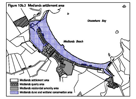
10b.6.1 Introduction
The Medlands settlement area is the second largest residential
area on Great Barrier. Running parallel to Medlands Beach and behind
the sand dunes, the settlement includes both permanent residences as
well as visitor activities based on small sites. Previous subdivision
has created smaller sites along the length of the beach in a ribbon
fashion, serviced by a road running over the sand dune system.
The settlement area is characterised by:
- Residential scale buildings along the
beachfront.
- Two streams providing a northern and southern
delineation of the settlement.
- Development that extends to the pastured
foothills along Medlands Road.
- A road creating a separation between the
fore dune and the residential area.
Oruawharo Stream adjoining the DOC campground near the
south end of Medlands is an important habitat for the brown teal duck.
On the other side of the stream, on the higher land rising above it,
the settlement area extends to include a small number of sites. The
Sugar Loaf promontory at the northern end of the beach is a prominent
landscape feature, with some extensive wetland areas separating the
quarry from the residential area.
The settlement plan (see figure 10b.2) identifies three
areas which recognise the residential nature of Medlands, as well as
the sensitive nature of the dunes and wetlands and provides for continued
use of the quarry. The future for Medlands will be in maintaining the
existing development pattern, with the residential area largely supporting
holiday bach accommodation over the summer months.
The Medlands settlement area has been divided into the
following sub-areas:
- residential amenity area
- dune and wetland conservation area
- quarry area.
The location of each of these is shown on figure 10b.2: Medlands settlement area.
The objectives and policies for the Medlands settlement
area are set out below. The objectives and policies for all settlements
areas contained in clause 10b.3 also apply.
10b.6.2 Objective
- Medlands settlement area
To recognise existing development and subdivision patterns
at Medlands Beach, while protecting the sensitive nature of the foredune,
wetlands and Oruawharo stream.
Policies
- By using indigenous vegetation to mitigate
the detrimental impact of erosion, instability or improve dune conservation.
- By limiting the adverse visual effects
of buildings through standards on colour, and ensuring that the natural
landscape remains the dominant element in terms of visual amenity.
- By considering the dynamic and sensitive
nature of sand dunes when assessing any resource consent and where consent
is granted, imposing conditions on buildings, earthworks and vegetation
removal that take account of the nature of the sand dunes.
- By ensuring that development is
subject to bulk, coverage and location controls, and where these standards
are exceeded, that the adverse effects are avoided or mitigated.
- By ensuring that land use activity
involving buildings, earthworks or vegetation removal does not adversely
affect Oruawharo Stream or its riparian areas, or reduce the ecological
value of the stream.
- By ensuring that all buildings are
located and are constructed in a manner which minimises disturbance
to indigenous vegetation and maximises, where appropriate, use of existing
cleared areas.
- By ensuring buildings are not visually
intrusive, either individually or cumulatively and that they respect
the scale of surrounding sand dunes and remain a minor visual element
within the sand dune landscape.
- By controlling the scale, form and
location of buildings in the Medlands dune and wetland conservation
area.
10b.6.3 Objective
- Medlands residential amenity area
To maintain and enhance the amenity of the residential
amenity area and to ensure development does not detrimentally impact
upon the adjoining dune and wetland conservation area.
Policies
- By limiting the footprint of buildings
to ensure that building sizes are of a residential scale.
- By providing for home occupations
and homestays as a permitted activity to enable an economic use of appropriate
scale for residential sites.
- By limiting activities that are
likely to have a detrimental effect on residential amenity due to effects
such as noise or traffic.
10b.6.4 Objective
- Medlands dune and wetland conservation area
To ensure that the sand dune, sand areas and wetland
areas of the dune and wetland conservation area remain in their natural
state and maintain their ecological functions.
Policies
- By ensuring that land use activity in
the vicinity of wetlands and rivers does not detrimentally impact upon,
alter or affect the water quality or quantity of those areas.
- By protecting important wetland,
dune and riparian areas through covenants or reserve requirements.
10b.6.5 Objective
- Medlands quarry area
To provide for continuing use of the Medlands quarry
as a source of rock materials for construction on the island, while
safeguarding surrounding wetland and residential areas.
Policies
- By providing for quarrying activities.
- By limiting the adverse effects
of quarrying activities on surrounding residential areas in terms of
noise and vibration.
- By limiting any adverse effects
on the adjacent wetland systems, with particular regard to silt, sediment
and dust.
10b.7 Objectives
and policies for Claris settlement area
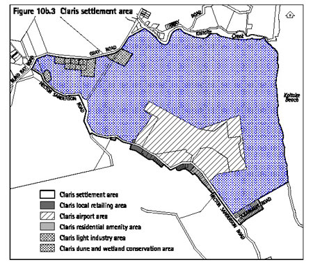
10b.7.1 Introduction
This settlement area is located on flat to rolling land
adjacent to Kaitoke beach and Kaitoke wetland, both of which are outstanding
in terms of landscape value and natural beauty. It contains the council
service centre, industrial activities, medical and community centres,
and the main grouping of shops on the east side of the island. It adjoins
the island's main airport, which is the arrival and departure point
for most travellers on regular flights to and from Auckland throughout
the year.
The Claris settlement area is characterised by:
- Mixed topography with areas of wetland,
rolling dunes, and flat alluvial pasture.
- Prominence due to its function as the
main receiving place for people arriving and leaving via Claris airport.
- Landscape importance due to its setting
near the coastal edge of the Kaitoke catchment adjoining the Kaitoke
wetland and Kaitoke beach. The proximity to these, their prominence
when arriving by air, and the visibility of the encompassing hills and
adjacent native vegetation from within the settlement area, all contribute
to the high landscape values that characterise this area and are representative
at this gateway to the island.
- Scattered facilities spread across the
settlement area, with industrial activities in the north, shops in the
middle, and residential in the south.
- A range of vegetation types, with pasture,
pine or indigeneous vegetation covered dunes, pasture covered alluvial
flats, and native sedges, grasses and flaxes throughout the wetland.
- Some areas of the dunes are prone to instability
due to fragile vegetation cover.
Overall, the Claris settlement area is a mix of unmodified
and modified land uses and dispersed activities within a larger setting
of high natural character and landscape value. The settlement plan identifies
five areas that recognise conservation values, and the airport, retail,
residential and industrial activities that may occur within these areas.
The future for Claris lies in consolidating activities and providing
structure to the commercial centre, making it a welcoming settlement
for island residents and visitors alike.
The Claris settlement area has been divided into the
following sub-areas:
- local retailing area
- residential amenity area
- airport area
- dune and wetland conservation area
- light industry area.
The location of each of these is shown on figure 10b.3:
Claris settlement area.
The objectives and policies for the Claris settlement
area are set out below. The objectives and policies for all settlement
areas contained in clause 10b.3 also apply.
10b.7.2 Objectives
- Claris settlement area
10b.7.2.1 Objective
To consolidate similar activities in the areas identified
to ensure that effects of activities do not affect the function of the
airport and surrounding activities.
Policies
- By preventing any building or land use
activity which may compromise the operation of the airport by being
sensitive to effects from the operation of the airport, with particular
regard to noise sensitivity and safety.
- By not providing for the construction,
alteration of, or addition to, any building that exceeds the height
limits for the airport protection fans identified for Claris airfield.
- By limiting the adverse visual effects
of buildings through standards on colour, and ensuring that the natural
landscape remains the dominant element in terms of visual amenity.
10b.7.2.2 Objective
To create a functioning centre for Great Barrier.
Policies
- By providing for retail premises and
further development to reinforce the role of the area as a gateway to
the island.
- By protecting activities in their
respective areas from reverse sensitivity effects.
10b.7.3 Objective
- Claris local retailing area
To facilitate the establishment of local retail, service
and visitor activities of high amenity in the local retailing area,
without compromising the function of Claris airport.
Policies
- By controlling the scale, form and location
of all new buildings in the Claris local retailing area in order to
maintain or enhance amenity of the Claris township.
- By requiring new activities in the
local retailing area to front the street and maintain a high standard
of amenity.
- By ensuring that new development
in the local retailing area blends in with rather than dominates existing
development.
- By ensuring that buildings are not
used for residential purposes, except where residential use is required
for managing other activities on the site.
- By encouraging visitor and retailing
activities to locate in close proximity to each other, facilitating
pedestrian movement and a cohesive and attractive commercial centre.
- By limiting and controlling activities
that may be sensitive to noise from the Claris airport.
- By providing for community and healthcare
facilities as permitted activities.
10b.7.4 Objective
- Claris residential amenity area
To maintain and enhance amenity and the existing patterns
of residential development to the south of Claris township.
Policies
- By limiting the footprint of buildings
to ensure that building sizes are of a residential scale.
- By providing for home occupations
and homestays as a permitted activity to enable an economic use of appropriate
scale for residential sites.
- By limiting activities that are
likely to have a detrimental effect on residential amenity due to effects
such as noise or traffic.
10b.7.5 Objective
- Claris airport area
To maintain and protect the function of the Claris airport
as the principal air transport link on the island and to ensure its
ongoing viability and safe functioning.
Policies
- By providing for the use, construction
and maintenance of runways, taxiways and drains as permitted activities.
- By limiting activities, including
buildings, to those which are necessary or have a commercial function
associated with the safe and viable functioning of the airport.
- By providing a high level of amenity
and appropriate activities to support the function of Claris airport,
to create a good first impression of Great Barrier for tourists.
10b.7.6 Objective
- Claris dune and wetland conservation areas
To conserve natural and modified sand areas and wetlands
and protect them from inappropriate use.
Policies
- By providing for sand dune stabilisation
and other conservation activities as permitted activities.
- By protecting the natural landscape
and ecological values of wetland and unmodified dune areas.
- By restricting activities that may
adversely affect the dune areas and wetlands.
- By restricting the encroachment
of inappropriate activities.
- By controlling the scale, form and
location of all new buildings in the Claris dune and wetland conservation
areas.
10b.7.7 Objective
- Claris light industry area
To provide for light industrial activities, while safeguarding
against adverse effects that could result in contamination of the Kaitoke
wetland, or other surrounding wetlands.
Policies
- By limiting any adverse effects of industrial
activities on adjacent sand or wetland systems.
- By not providing for sensitive activities
to establish in the industrial area and therefore avoiding reverse sensitivity
effects on industrial activities.
- By recognising the need for a source
of sand for construction on Great Barrier, without compromising any
ecological or natural functions of the surrounding area.
10b.8 Objectives
and policies for Okupu settlement area
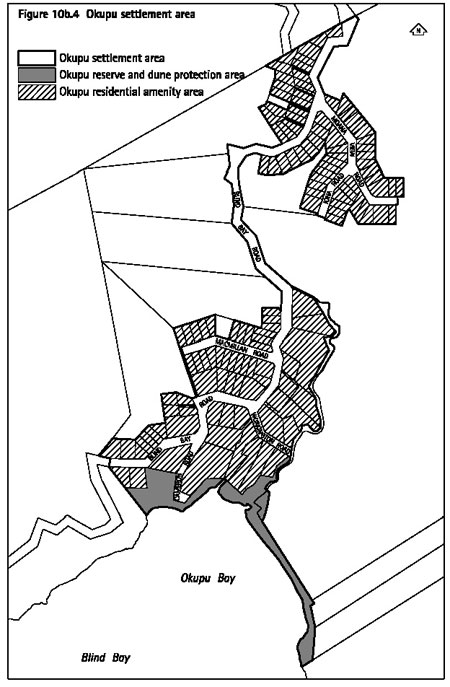
10b.8.1 Introduction
This settlement area is located on bush covered slopes
on the western side of the Great Barrier. Existing houses are located
in two main areas: one on and near the ridgeline, the other on the lower
slopes and running down to the coastal edge.
The Okupu settlement area is characterised by:
- Sloping topography, with a dominance of
regenerating indigenous vegetation.
- A dense grouping of housing along the
ridgeline.
- Small scale residential development spread
across the sloping topography among regenerating vegetation.
- Residential development which is dominated
by the scale and prominence of the regenerating vegetation in terms
of both land cover and landscape character.
- With the exception of the ridgeline, residential
activities are generally well integrated into the vegetated setting
and sloping topography of the settlement area.
- A dominance of particularly large pohutukawa
in the open space of the coastal interface area, creating an area of
high amenity value.
The settlement area identifies two areas reflecting
the residential and reserve and dune areas and the activities that may
occur within them. The settlement area will continue to provide for
development of existing sites within its boundaries.
The Okupu settlement area has been divided into two
sub-areas:
- residential amenity area
- reserve and dune protection area.
The location of each of these is shown on figure 10b.4: Okupu settlement area.
The objectives and policies for the Okupu settlement
area are set out below. The objectives and policies for all settlements
areas contained in clause 10b.3 also apply.
10b.8.2 Objective
- Okupu settlement area
To contain the existing subdivision pattern, avoiding
expansion of the settlement area, and provide for appropriate development
on existing sites within the settlement area as a means for maintaining
landscape and ecological values of the area.
Policies
- By controlling the adverse visual effects
of buildings through standards on colour, and ensuring that the natural
landscape remains the dominant element in terms of visual amenity.
- By controlling the adverse effects
of buildings on the environment through bulk, coverage and location
controls and where these standards are exceeded, ensuring that the adverse
effects are avoided or mitigated.
- By limiting the removal of indigenous
vegetation so that drainage, stormwater and sedimentation problems are
mitigated or avoided, and landscape values are maintained.
- By protecting riparian areas around
streams and requiring replanting to maintain and enhance water quality.
- By only including existing development
within the Okupu settlement area.
10b.8.3 Objective
- Okupu residential amenity area
To maintain or enhance the low impact character and
amenity of the Okupu residential amenity area.
Policies
- By limiting the footprint of buildings
to ensure that building sizes are of a residential scale.
- By providing for home occupations
and homestays as a permitted activity to enable an economic use of appropriate
scale for residential sites.
- By limiting activities that are
likely to have a detrimental effect on residential amenity due to adverse
effects such as noise or traffic.
10b.8.4 Objective
- Okupu reserve and dune protection area
To maintain the coastal interface contained in the reserve
and dune protection area as important areas due to their visual amenity
and ecological values.
Policy
- By maintaining the natural appearance
and ecological function of the Okupu dune and beach area.
- By recognising the need for any
public facilities to be controlled in terms of location and design.
- By enabling conservation and beach
enhancement activities, while preventing inappropriate activities from
occurring.
10b.9 Objectives
and policies for Whangaparapara settlement area
10b.9.1 Introduction
This settlement area is located in a small bay on the
western side of Great Barrier. Development surrounding Whangaparapara
is comprised of visitor accommodation with associated activities, residential
activities, and a wharf.
The Whangaparapara settlement area is characterised
by:
- A small bay, enclosed by sloping topography
and bush clad hills.
- Residential development that is integrated
amongst the regenerating indigenous vegetation on the slopes above the
bay.
- Large pohutukawa that line the shore.
- Visitor accommodation with associated
activities that attracts travellers, exposing the high natural character
of the area to a wide range of people.
- Proximity to a small scale wharf that
integrates well with the marine activities and character of the sheltered
harbour, and provides an important access point for supply of materials
to the island.
The Whangaparapara settlement area provides for visitor
accommodation and small scale residential living within an area of high
natural character and landscape value. The future for Whangaparapara
involves protecting the wharf and visitor accommodation, maintaining
the high landscape qualities, and providing for the existing residential
area without any further expansion into the surrounding catchment.
The Whangaparapara settlement area has been divided
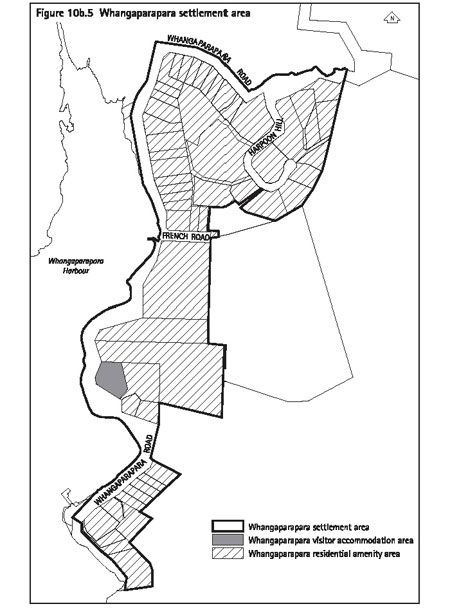
into the following sub-areas:
- residential amenity area
- visitor accommodation area.
The location of each of these is shown on figure 10b.5: Whangaparapara settlement area.
The objectives and policies for the Whangaparapara settlement
area are set out below. The objectives and policies for all settlements
areas contained in clause 10b.3 also apply
10b.9.2 Objective
- Whangaparapara settlement area
To maintain the high value natural character of the
wider Whangaparapara area, and protect the function of the visitor accommodation.
Policies
- By limiting the adverse visual effects
of buildings through standards on colour, and ensuring that the natural
landscape remains the dominant element in terms of visual amenity.
- By controlling adverse effects of
buildings on the environment through bulk, coverage and location controls,
and where these standards are exceeded, ensuring that the adverse effects
are avoided or mitigated.
- By limiting the removal of indigenous
vegetation so that drainage, stormwater and sedimentation problems are
mitigated or avoided, and landscape values are maintained.
- By protecting riparian areas around
streams and requiring replanting to maintain or enhance water quality.
- By only including existing development
within the Whangaparapara settlement area.
10b.9.3 Objective
- Whangaparapara residential amenity area
To maintain the low impact, bush covered character of
the Whangaparapara residential amenity area.
Policies
- By limiting the footprint of buildings
to ensure building sizes are of a residential scale.
- By providing for home occupations
and homestays as a permitted activity to enable an economic use of appropriate
scale for residential sites.
- By limiting activities that are
likely to have a detrimental effect on residential amenity due to effects
such as noise or traffic.
10b.9.4 Objective
- Whangaparapara visitor accommodation area
To provide for the long term function of the existing
visitor accommodation and associated activities at Whangaparapara.
Policies
- By providing for activities that will
support the function of the tourist complex.
- By ensuring that residential activities
are only allowed where they are required for the management of tourist
complex.
10b.10 Objectives
and policies for Awana settlement area
10b.10.1 Introduction
This settlement area is located at the southern end
of a white sand bay on the eastern side of the island. It is enclosed
by steeply sloping headlands at either end. Development is focused on
a group of houses located on the sloping hillside and lower land overlooking
the beach and bay.
The settlement area is characterised by:
- Well integrated housing that is set amongst
the regenerating indigenous vegetation on the slopes above the bay.
- A built up character that is primarily
contributed to by the visibility of a small group of housing by the
road on the lower slopes of the hillside and a single house on the foredune.
- A picturesque setting, with the settlement
area surrounded by dominant landforms, rural landscapes, a beautiful
beach, and undeveloped dune.
Overall, the Awana settlement area provides for well
integrated and small scale residential living overlooking a bay that
is valued for its natural and undeveloped character. The strategy for
the Awana settlement is to strictly maintain development within the
boundaries of the settlement in order to retain the dominance of the
natural and rural surroundings.
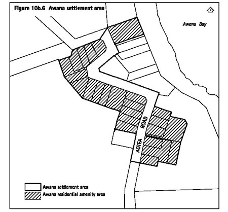
The Awana settlement area consists entirely of a residential
amenity area. The location of the settlement area is shown on
figure
10b.6: Awana settlement area.
The objectives and policies for the Awana settlement
area are set out below. The objectives and policies for all settlements
areas contained in clause 10b.3 also apply.
10b.10.2 Objective
- Awana settlement area
To maintain and enhance the low impact character of
the Awana residential amenity area, and ensure that new development
integrates with the sensitive landscape qualities of the Awana beachfront
area.
Policies
- By limiting the adverse visual effects
of buildings through standards on colour, and ensuring that the natural
landscape remains the dominant element in terms of visual amenity.
- By limiting the footprint of buildings
to ensure that building sizes are of a residential scale.
- By ensuring that development is
subject to bulk, coverage and location controls, and where these standards
are exceeded, that the adverse effects are avoided or mitigated.
- By limiting removal of indigenous
vegetation (particularly coastal shrubs) in order that drainage, stormwater
and sedimentation problems are reduced or avoided and landscape values
are maintained.
- By providing for home occupations
and homestays as a permitted activity to enable an economic use of an
appropriate scale for residential sites.
- By limiting activities that are
likely to have a detrimental effect on residential amenity due to effects
such as noise or traffic.
- By only including existing development
within the Awana settlement area.
10b.11 Objectives
and policies for Okiwi settlement area
10b.11.1 Introduction
This settlement area is located on the gently sloping
foothills of the Whangapoua Basin, two kilometres inland from Okiwi
airport. A primary school, sports fields and small collection of houses
make up the area, along with an area of rolling pasture. An area has
been identified which offers an opportunity for extending the existing
settlement.
The settlement area is characterised by:
- Infrastructure of an existing settlement
including local primary school, bus transport, proximity to the Okiwi
airstrip, and an existing community.
- Traditional residential settlement pattern
concentrated into a small settlement on the lower slopes of the surrounding Whangapoua basin.
- Undeveloped land within the settlement
area that gives opportunity for additional growth within and adjacent
to the existing housing area.
- A modified landscape within a pastoral
setting, with a backdrop of sloping hills and regenerating vegetation.
Okiwi is able to support additional commercial activities
and provide a centre for the north of the island. The settlement plan
identifies three areas providing for residential, retailing and the
school including recreational areas. The settlement plan also provides
for additional residential growth in an area that is close to existing
amenities, without compromising the rural and scenic qualities of the
greater Whangapoua catchment.
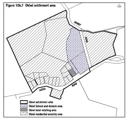
The Okiwi settlement area has been divided into the
following sub-areas:
- residential amenity area
- Okiwi School and domain area
- local retailing area.
The location of each of these is shown on figure 10b.7: Okiwi settlement area.
The objectives and policies for the Okiwi settlement
area are set out below. The objectives and policies for all settlements
areas contained in clause 10b.3 also apply
10b.11.2 Objective
- Okiwi settlement area
To provide for residential development in the north
of the island, and to support small scale commercial, education and
recreation activities, while protecting existing vegetation and riparian
areas.
Policies
- By limiting the adverse visual effects
of buildings through standards on colour and ensuring that the natural
landscape remains the dominant element in terms of visual amenity.
- By ensuring that development is
subject to bulk, coverage and location controls, and where these standards
are exceeded, that the adverse effects are avoided or mitigated.
- By limiting removal of indigenous
vegetation in order that drainage, stormwater and sedimentation problems
are reduced or avoided and landscape values are maintained.
- By requiring replanting of indigenous
vegetation where new development requiring resource or subdivision consent
is proposed.
- By protecting riparian areas around
streams and requiring replanting to maintain water quality.
- By allowing for additional residential
sites to be created within the Okiwi settlement area.
10b.11.3 Objective
- Okiwi residential amenity area
To maintain and enhance the low impact character of
the residential amenity area.
Policies
- By limiting the footprint of buildings
to ensure that building sizes are of a residential scale.
- By providing for home occupations
and homestays as a permitted activity to enable an economic use of appropriate
scale for residential sites.
- By limiting activities that are
likely to have a detrimental effect on residential amenity due to effects
such as noise or traffic.
- By ensuring that where new subdivision
occurs, that it protects riparian areas and avoids culverting of stream
areas in favour of bridging where necessary.
10b.11.4 Objective
- Okiwi School and Domain area
To recognise the importance of Okiwi School and sports
fields to the northern Great Barrier community.
Policies
- By enabling a range of activities at
Okiwi School to assist with sustaining its viability and provide a focus
for the community of Okiwi.
- By enabling the ongoing recreational
use of the Okiwi Domain.
10b.11.5 Objective
- Okiwi local retailing area
To provide an area for commercial activities which are
compatible with the character and scale of Okiwi, to service the north
part of Great Barrier.
Policies
- By requiring assessment of the scale,
form and location of all new buildings in the Okiwi local retailing
area to maintain or enhance amenity of the Okiwi township.
- By ensuring that new development
in the local retail area blends with rather than dominates existing
development.
- By ensuring that premises are not
used for residential purposes, except where it is for the purpose of
managing other activities on the site.
10b.12 Objectives
and policies for Port Fitzroy settlement area
10b.12.1 Introduction
This settlement area is located in a large harbour on
the western side of the island. Development comprises mainly residential
activities. An area with wharf facilities, it is popular with recreational
boating traffic and is an access point for goods entering or leaving
the island.
The settlement area is characterised by:
- A small bay, enclosed by sloping topography
and hills clad in indigenous vegetation, some of which is well advanced
in terms of regeneration.
- Small scale residential development that
is integrated amongst the bush on the slopes above the bay.
- A wharf that services the popular marine
activities of the sheltered harbour and provides an access point for
materials entering and leaving the island.
The settlement plan identifies two areas reflecting
the residential and retailing activities of Port Fitzroy, and overall
provides for small scale residential living within an area of high natural
character and landscape value. The high values of the landscape in the
harbour mean that the settlement area is tightly constrained to existing
development and subdivision patterns.
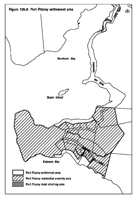
The Port Fitzroy settlement area has been divided into
the following sub-areas:
- residential amenity area
- local retailing area.
The location of each of these is shown on figure 10b.8:
Port Fitzroy settlement area.
The objectives and policies for the Port Fitzroy settlement
area are set out below. The objectives and policies for all settlements
areas contained in clause 10b.3 also apply
10b.12.2 Objective
- Port Fitzroy settlement area
To maintain existing development patterns and protect
the bush covered character of the Port Fitzroy settlement.
Policies
- By limiting the adverse visual effects
of buildings through standards on colour, and ensuring that the natural
landscape remains the dominant element in terms of visual amenity.
- By limiting removal of indigenous
vegetation in order that drainage, stormwater and sedimentation problems
are reduced or avoided and landscape values are maintained.
- By ensuring that development is
subject to bulk, coverage and location controls, and where these standards
are exceeded, that the adverse effects are avoided or mitigated.
- By protecting riparian areas around
streams and requiring replanting to maintain or enhance water quality.
10b.12.3 Objective
- Port Fitzroy residential amenity area
To protect and enhance the low impact bush covered character
of the residential amenity area.
Policies
- By limiting the footprint of buildings
to ensure building sizes are of a residential scale.
- By providing for home occupations
and homestays as a permitted activity to enable an economic use of appropriate
scale for residential sites.
- By limiting activities that are
likely to have a detrimental effect on residential amenity due to effects
such as noise or traffic.
10b.12.4 Objective
- Port Fitzroy local retailing area
To provide for local retailing which is compatible with
the character of Port Fitzroy.
Policies
- By requiring an assessment of the scale,
form and location of all new buildings in the Port Fitzroy local retailing
area in order to maintain a high level of amenity.
- By ensuring that new development
in the local retailing area blends with rather than dominates existing
development.
- By ensuring that premises are not
used for residential purposes, except where it is for the purpose of
managing other activities on the site.
10b.13 Objectives
and policies for Aotea settlement area
10b.13.1 Introduction
Aotea is the name for the settlement that encompasses
Motairehe, Kaoa and a number of other settlements throughout the Katherine
Bay area on the ancestral Maori land of Ngati Rehua, the ahi kaa for
Great Barrier.
The characteristics of the area include:
- Low key settlement and housing.
- Extensive areas of regenerating bush.
- Pebble beaches with pohutukawa forest
extending down to the beach.
- Small bays marking the location of areas
of existing settlement.
The area provides a home for Ngati Rehua, and with an
ageing Auckland-based population, it is likely that the population will
rise into the future. The settlement plan provides for residential activities,
until such time as a further plan is developed to enable further growth
for the island based community.
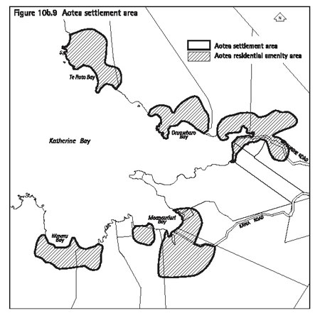
The Aotea settlement area consists entirely of a residential
amenity area. The location of the settlement area is shown on
figure
10b.9: Aotea settlement plan.
The objectives and policies for the Aotea settlement
area are set out below. The objectives and policies for all settlements
areas contained in clause 10b.3 also apply
10b.13.2 Objective
- Aotea settlement area
To maintain the low impact character of the Aotea settlement
on ancestral Maori land at Kaoa.
Policies
- By limiting the adverse visual effects
of buildings through standards on colour, and ensuring that the natural
landscape remains the dominant element in terms of visual amenity.
- By providing for home occupations
and homestays as a permitted activity to enable an economic use of appropriate
scale for residential sites.
- By ensuring that development is
subject to bulk, coverage and location controls, and where that where
these standards are exceeded only minor adverse effects occur.
- By protecting riparian areas around
streams to maintain or enhance water quality.
- By limiting removal of indigenous
vegetation in order that drainage, stormwater and sedimentation problems
are reduced or avoided and landscape values are maintained.
- By locating buildings to minimise
any potential impact from flooding.
10b.13.3 Objective
- future development in Aotea settlement area
To establish a resource management framework whereby
Ngati Rehua can provide for the sustainable use of ancestral land.
Policies
- By assessing the adverse effects of activities
that are not residential in nature on a case by case basis, until a
site specific plan has been prepared.
- By recognising that the development
of a comprehensive plan for the Aotea settlement area is desirable,
either by a comprehensive resource consent application or through a
structure plan to be incorporated into the Plan.
- By treating subdivision as a non-complying
activity to protect ancestral land for future generations.
- By providing for papakainga housing
as a discretionary activity to assess multiple dwellings on a case-by-case
basis until such time as a comprehensive plan is undertaken.
10b.14 Introduction
to activity tables
The remainder of this part contains the activity tables
for the nine settlement areas. As shown on the settlement plans (figures
10b.1-9), each settlement area has been further divided into sub-areas.
The activity tables and any related information have been organised
according to the following sub-areas:
- residential amenity areas
- local retailing areas
- headland protection area
- visitor accommodation area
- reserve, dune, coastal margin and wetland
conservation areas
- Claris light industry area
- Claris airport area
- Mulberry Grove School, and Okiwi School
and Domain area
- Medlands quarry area.
Apart from the Medlands quarry area, all of the development
controls for the settlement areas are in part 10c - Development controls
for land units and settlement areas. There are some specific development
controls for the quarry in this part.
10b.15 Residential
amenity areas
There are residential amenity areas in all nine settlement
areas: ie Tryphena, Medlands, Claris, Okupu, Whangaparapara, Awana,
Okiwi, Port Fitzroy and Aotea. The location of the residential amenity
area for each settlement area is identified on the applicable settlement
plans (figures 10b.1-9).
10b.15.1 Rules - activity
table
Activity
|
Status
|
Accommodation for care
|
P
|
Accommodation for retired, elderly
or disabled people
|
P
|
Art galleries and museums
|
P
|
Boarding house or hostel
|
D
|
Boarding kennels and catteries
|
D
|
Camping facilities
|
D
|
Care centres
|
P
|
Community facilities
|
P
|
Dairy
|
D
|
Dwelling (one per site)
|
P
|
Educational facilities
|
D
|
Entertainment facilities
|
D
|
Function facilities
|
D
|
Healthcare services
|
D
|
Home occupations
|
P
|
Homestay
|
P
|
Multiple dwellings
|
D
|
Offices
|
D
|
Papakainga housing
|
D
|
Residential accessory buildings
|
P
|
Restaurant, cafe and other eating
places
|
D
|
Retail premises
|
D
|
Tourist complex
|
D
|
Visitor accommodation
|
D
|
Legend
P = Permitted
D = Discretionary
Notes:
- The relationship between buildings and
other activities listed in activity tables is explained in
clause 4.3.
- The activities of earthworks and
vegetation clearance are treated as development controls and are therefore
not listed in this table.
Explanation
The activities in the residential amenity areas are
intended to provide for low impact small scale activities to ensure
that the level of residential amenity in the settlement area is maintained.
10b.15.2 Rules
- standards and terms for multiple dwellings
An application for multiple dwellings will only be considered
as a discretionary activity where one or more of the following criteria
are met:
- The resulting number of dwellings on
the site will be no more than that which would occur if the site were
subdivided in accordance with the rules in part 12 - Subdivision applying
to this land unit (with one dwelling per site).
- An application is made at the same
time for subdivision resulting in the amalgamation of sites such that
the number of dwellings on the new site created would be no greater
than that which could be achieved through locating a dwelling on each
of the original sites.
- The land has been owned co-operatively
by a number of individuals since prior to 29 September 1992.
Proposals which do not meet these standards are a non-complying
activity.
10b.15.3 Rules
- development controls
Refer to part 10c - Development controls for land units
and settlement areas for the controls applying in the residential amenity
areas. The development controls listed in that part apply to all activities
whether or not those activities are otherwise permitted, restricted
discretionary, discretionary or non-complying. Infringements to these
development controls will be considered as development control modifications
as set out in clause 10c.3.
10b.15.4 Assessment
matters
For applications for resource consent refer to part
11 - Assessment matters for assessment criteria for discretionary activities.
10b.16 Local retailing
areas
There are local retailing areas in the following settlement
areas: Tryphena, Claris, Okiwi and Port Fitzroy. The location of the
local retailing area for each settlement area is identified on the applicable
settlement plan (Tryphena - figure 10b.1, Claris -
figure 10b.3, Okiwi
- figure 10b.7 and Port Fitzroy -
figure 10b.8).
10b.16.1 Rules - activity table
Activity
|
Status
|
The construction and relocation
of buildings, including buildings used for any of the other activities
listed in this table1
|
RD
|
Alterations and additions to the
exterior of existing buildings including buildings used for any of the
other activities listed in this table. However this does not apply to
minor alterations and additions as defined in part 14 - Definitions1
|
RD
|
Accommodation for care
|
D
|
Accommodation for retired, elderly
or disabled people
|
D
|
Art galleries and museums
|
P
|
Boarding house or hostel
|
P
|
Camping facilities
|
D
|
Care centre
|
D
|
Community facilities 2
|
P
|
Dairy
|
P
|
Dwelling (one per site)
|
RD
|
Educational facilities 2
|
P
|
Entertainment facilities
|
P
|
Function facilities
|
P
|
Funeral parlour
|
P
|
Healthcare services 2
|
P
|
Home occupation on existing sites
with an established residential use
|
P
|
Homestay on existing sites with
an established residential use
|
P
|
Motor vehicle sales
|
P
|
Motor vehicle services
|
P
|
Multiple dwellings
|
D
|
Offices
|
P
|
Open air market
|
P
|
Restaurant, cafe and other eating
places
|
P
|
Retail premises
|
P
|
Service station
|
D
|
Tavern
|
P
|
Tourist complex
|
D
|
Visitor accommodation
|
P
|
Legend
P = Permitted
RD = Restricted discretionary
D = Discretionary
Notes:
- In the local retailing areas, the activities
of constructing or relocating buildings, or undertaking exterior alterations
and additions to existing buildings, are to be treated as separate from
the activity of using buildings for any of the permitted activities
listed in the table. Therefore, even when an activity is permitted in
this table, a resource consent may still be required for any construction
or relocation of, or any exterior alteration or addition to, the building
used for the activity. The relationship between buildings and other
activities listed in activity tables is explained further in
clause
4.3.
- Where these activities are located
in the Claris local retailing area, their status may be affected by
the noise management controls in clause 10c.5.5.
- The activities of earthworks and
vegetation clearance are treated as development controls and are therefore
not listed in this table.
Explanation
The location of dwellings needs to be controlled so
residential uses do not occupy space that should be reserved for retailing
activities. The scale and form of buildings is controlled to ensure
that development that takes place is of a high quality, and creates
a positive contribution towards the island character.
10b.16.2 Rules
- standards and terms for multiple dwellings
An application for multiple dwellings will only be considered
as a discretionary activity where one or more of the following criteria
are met:
- The resulting number of dwellings on
the site will be no more than that which would occur if the site were
subdivided in accordance with the rules in part 12 - Subdivision applying
to this land unit (with one dwelling per site).
- An application is made at the same
time for subdivision resulting in the amalgamation of sites such that
the number of dwellings on the new site created would be no greater
than that which could be achieved through locating a dwelling on each
of the original sites.
- The land has been owned co-operatively
by a number of individuals since prior to 29 September 1992.
Proposals which do not meet these standards are a non-complying
activity.
10b.16.3 Rules
- development controls
Refer to part 10c- Development controls for land units
and settlement areas for the controls applying in the local retailing
areas. The development controls listed in that part apply to all activities
whether or not those activities are otherwise permitted, restricted
discretionary, discretionary or non-complying. Infringements to these
development controls will be considered as development control modifications
as set out in clause 10c.3.
10b.16.4 Assessment matters
- Matters of discretion for dwellings
When considering an application for resource consent
for a dwelling, the council has restricted its discretion to considering
the following matters:
- Whether the dwelling takes up ground
level space that could otherwise be used for retail or other non-residential
activities.
- Whether the dwelling is required
on site to manage an activity on the site.
- Whether the dwelling has sufficient
acoustic insulation to mitigate noise effects arising from airport activities.
- Other listed activities
For other applications for resource consent refer
to part 11 - Assessment matters for:
- Matters of discretion and notification
requirements applying to the construction and relocation of buildings
and to exterior alterations and additions to existing buildings.
- Assessment criteria for discretionary
activities.
10b.17 Headland protection area
There is a headland protection area in the Tryphena
settlement area. The location of the headland protection area is identified
on the settlement plan for Tryphena (figure 10b.1).
10b.17.1 Rules
Activity
|
Status
|
The construction and relocation
of buildings, including buildings used for any of the other activities
listed in this table1
|
RD
|
Alterations and additions to the
exterior of existing buildings including buildings used for any of the
other activities listed in this table. However this does not apply to
minor alterations and additions as defined in part 14 - Definitions1
|
RD
|
Dwelling (one per site)
|
P
|
Home occupations
|
P
|
Homestay
|
P
|
Multiple dwellings
|
D
|
Residential accessory buildings
|
P
|
Visitor accommodation
|
D
|
Legend
P = Permitted
RD = Restricted discretionary
D = Discretionary
Notes:
- In the headland protection area, the
activities of constructing or relocating buildings, or undertaking exterior
alterations and additions to existing buildings, are to be treated as
separate from the activity of using buildings for any of the permitted
activities listed in the table. Therefore, even when an activity is
permitted in this table, a resource consent may still be required for
any construction or relocation of, or any exterior alteration or addition
to, the building used for the activity. The relationship between buildings
and other activities listed in activity tables is explained further
in clause 4.3.
- The activities of earthworks and
vegetation clearance are treated as development controls and are therefore
not listed in this table.
Explanation
The headlands at Tryphena are particularly sensitive
to development. A limited range of activities are provided for to limit
the potential for adverse effects that may result from larger developments.
Of particular importance is the blending in of buildings into the environment,
and the scale, form and location of buildings are carefully controlled
to achieve this.
10b.17.2 Rules
- standards and terms for multiple dwellings
An application for multiple dwellings will only be considered
as a discretionary activity where one or more of the following criteria
are met:
- The resulting number of dwellings on
the site will be no more than that which would occur if the site were
subdivided in accordance with the rules in part 12 - Subdivision applying
to this land unit (with one dwelling per site).
- An application is made at the same
time for subdivision resulting in the amalgamation of sites such that
the number of dwellings on the new site created would be no greater
than that which could be achieved through locating a dwelling on each
of the original sites.
- The land has been owned co-operatively
by a number of individuals since prior to 29 September 1992.
Proposals which do not meet these standards are a non-complying
activity.
10b.17.3 Rules
- development controls
Refer to part 10c- Development controls for land units
and settlement areas for the controls applying in the headland protection
area. The development controls listed in that part apply to all activities
whether or not those activities are otherwise permitted, restricted
discretionary, discretionary or non-complying. Infringements to these
development controls will be considered as development control modifications
as set out in clause 10c.3.
10b.17.4 Assessment
matters
For applications for resource consent refer to part
11 - Assessment matters for:
- Matters of discretion and notification
requirements applying to the construction and relocation of buildings
and to exterior alterations and additions to existing buildings.
- Assessment criteria for discretionary
activities.
10b.18 Visitor
accommodation area
The visitor accommodation area relates to a single site
located at Whangaparapara. The location of the visitor accommodation
area is identified on the settlement plan for Whangaparapara (figure
10b.5).
10b.18.1 Rules - activity table
Activity
|
Status
|
Boarding house or hostel
|
D
|
Camping facilities
|
P
|
Dairy
|
P
|
Dwelling (one per site)
|
RD
|
Entertainment facilities
|
D
|
Function facilities
|
P
|
Restaurant, cafe and other eating
places
|
P
|
Retail premises
|
D
|
Tavern
|
P
|
Tourist complex
|
P
|
Visitor accommodation
|
P
|
Legend
P = Permitted
RD = Restricted discretionary
D = Discretionary
Notes:
- The relationship between buildings and
other activities listed in activity tables is explained in
clause 4.3.
- The activities of earthworks and
vegetation clearance are treated as development controls and are therefore
not listed in this table.
Explanation
Accommodation and tourism activities are provided for.
To protect the future use of the site, residential use is limited to
managers' accommodation.
10b.18.2 Rules
- development controls
Refer to part 10c- Development controls for land units
and settlement areas for the controls applying in the visitor accommodation
area. The development controls listed in that part apply to all activities
whether or not those activities are otherwise permitted, restricted
discretionary, discretionary or non-complying. Infringements to these
development controls will be considered as development control modifications
as set out in clause 10c.3.
10b.18.3 Assessment matters
- Matters of discretion for dwellings
When considering an application for resource consent
for a dwelling, the council has restricted its discretion to considering
the following matters:
- Whether the dwelling takes up space that
would otherwise be used for visitor accommodation purposes.
- Whether the dwelling is required
on site to manage an activity on the site.
- Other listed activities
For other applications for resource consent refer
to part
11 - Assessment matters for assessment criteria for discretionary
activities.
10b.19 Reserve,
dune, coastal margin and wetland conservation areas
The reserve, dune, coastal margin and wetland conservation
areas are located in the following settlement areas:
The location of these areas for each settlement area
is identified on the applicable settlement plan.
10b.19.1 Rules - activity table
Activity
|
Status
|
The construction and relocation
of buildings, including buildings used for any of the other activities
listed in this table1
|
RD
|
Alterations and additions to the
exterior of existing buildings including buildings used for any of the
other activities listed in this table. However this does not apply to
minor alterations and additions as defined in part 14 - Definitions1
|
RD
|
Any activity that is provided
for in a reserve management plan under the Reserves Act (1977)
|
P
|
Conservation activities
|
P
|
Home occupations
|
P
|
Dwelling (one per site)
|
P
|
Homestay
|
P
|
Residential accessory buildings
|
P
|
Legend
P = Permitted
RD = Restricted discretionary
Notes:
- In the reserve, dune, coastal margin
and wetland conservation areas, the activities of constructing or relocating
buildings, or undertaking exterior alterations and additions to existing
buildings, are to be treated as separate from the activity of using
buildings for any of the permitted activities listed in the table. Therefore,
even when an activity is permitted in this table, a resource consent
may still be required for any construction or relocation of, or any
exterior alteration or addition to, the building used for the activity.
The relationship between buildings and other activities listed in activity
tables is explained further in clause 4.3.
- The activities of earthworks and
vegetation clearance are treated as development controls and are therefore
not listed in this table.
Explanation
Within the settlement areas, particular areas have been
identified that need particular care from an ecological, hazard and
amenity perspective, in terms of activities that can occur. The dune
areas maintain an important function in terms of protection from the
sea, with the wetland areas providing an important habitat for local
flora and fauna. The reserves and coastal margins in Tryphena contain
a number of residential sites. It is important for maintaining the sensitive
coastal landscape, that any building or construction activity in these
areas is carefully controlled.
10b.19.2 Rules
- development controls
Refer to part 10c- Development controls for land units
and settlement areas for the controls applying in the reserve, dune,
coastal margin and wetland conservation areas. The development controls
listed in that part apply to all activities whether or not those activities
are otherwise permitted, restricted discretionary, discretionary or
non-complying. Infringements to these development controls will be considered
as development control modifications as set out in clause 10c.3.
10b.19.3 Assessment
matters
For applications for resource consent refer to part
11 - Assessment matters for:
- Matters of discretion and notification
requirements applying to the construction and relocation of buildings
and to exterior alterations and additions to existing buildings.
- Assessment criteria for discretionary
activities.
10b.20 Claris
light industry area
The location of the Claris light industry area is shown
on the Claris settlement plan (figure 10b.3).
10b.20.1 Rules - activity
table
Activity
|
Status
|
Art galleries and museums
|
P
|
Boarding kennels and catteries
|
P
|
Commercial firewood harvesting1
|
D
|
Dairy
|
P
|
Funeral parlour
|
P
|
Home occupations on existing sites
with an established residential use
|
P
|
Horticulture
|
P
|
Industry
|
P
|
Motor vehicle services
|
P
|
Refuse transfer station
|
D
|
Restaurant, cafe and other eating
places
|
D
|
Sand quarrying
|
D
|
Service station
|
D
|
Winery
|
P
|
Legend
P = Permitted
RD = Restricted discretionary
D = Discretionary
Notes:
- Commercial firewood harvesting is not
expected to comply with the vegetation clearance controls set out in
part 10c - Development controls for land units and settlement areas
for the Claris light industry area.
- The activities of earthworks and
vegetation clearance (other than for commercial firewood harvesting)
are treated as development controls and are therefore not listed in
this table.
- The relationship between buildings
and other activities listed in activity tables is explained in
clause
4.3.
Explanation
The Claris light industry area has historically provided
for activities with higher adverse effects, such as panelbeating, the
landfill, and milling activities. Industrial activities that may contaminate
ground or water sources in the area need to be carefully controlled
due to the porous sand nature of the surrounding area. There is a particular
need to ensure that reverse sensitivity issues are addressed so that
the higher impact activities can locate in the vicinity, and that lower
impact or sensitive activities are located in more appropriate locations.
Residential use is a non-complying activity, although there will be
some continuing existing uses, and where these exist home occupations
are able to be undertaken on the site.
10b.20.2 Rules
- development controls
Refer to part 10c - Development controls for land units
and settlement areas for the controls applying in the Claris light industry
area. The development controls listed in that part apply to all activities
whether or not those activities are otherwise permitted, restricted
discretionary, discretionary or non-complying. Infringements to these
development controls will be considered as development control modifications
as set out in clause 10c.3.
10b.20.3 Assessment
matters
For applications for resource consent refer to part
11 - Assessment matters for assessment criteria for discretionary activities.
10b.21 Claris
airport area
The location of the Claris airport area is shown on
the Claris settlement plan (figure 10b.3).
10b.21.1 Rules - activity table
Activity
|
Status
|
The construction and relocation
of buildings, including buildings used for any of the other activities
listed in this table1
|
RD
|
Alterations and additions to the
exterior of existing buildings including buildings used for any of the
other activities listed in this table. However this does not apply to
minor alterations and additions as defined in part 14 - Definitions1
|
RD
|
Airstrip, including the construction
and maintenance of runways, taxiways and drains
|
P
|
Commercial carparking
|
P
|
Helipad
|
P
|
Offices
|
P
|
Restaurant, cafe and other eating
places
|
P
|
Retail premises
|
P
|
Legend
P = Permitted
RD = Restricted discretionary
Notes:
- In the Claris airport area, the activities
of constructing or relocating buildings, or undertaking exterior alterations
and additions to existing buildings, are to be treated as separate from
the activity of using buildings for any of the permitted activities
listed in the table. Therefore, even when an activity is permitted in
this table, a resource consent may still be required for any construction
or relocation of, or any exterior alteration or addition to, the building
used for the activity. The relationship between buildings and other
activities listed in activity tables is explained further in
clause
4.3.
- The activities of earthworks and
vegetation clearance are treated as development controls and are therefore
not listed in this table.
Explanation
Claris airport provides the major air linkage for Great
Barrier, and it is the start of the Great Barrier experience for many
of the tourists that come the island. It is important that the airport
has a high level of amenity, and provides services that will assist
with the tourist experience. The activities identified provides for
supporting services that will contribute to the area as a gateway.
10b.21.2 Rules
- development controls
Refer to part 10c- Development controls for land units
and settlement areas for the controls applying in the Claris airport
area. The development controls listed in that part apply to all activities
whether or not those activities are otherwise permitted, restricted
discretionary, discretionary or non-complying. Infringements to these
development controls will be considered as development control modifications
as set out in clause 10c.3.
10b.21.3 Assessment
matters
For applications for resource consent refer to part
11 - Assessment matters for:
- Matters of discretion and notification
requirements applying to the construction and relocation of buildings
and to exterior alterations and additions to existing buildings.
- Assessment criteria for discretionary
activities.
10b.22 Mulberry
Grove School, and Okiwi School and Domain areas
The Mulberry Grove School area is located in the Tryphena
settlement area. The Okiwi School and Domain area is located in the
Okiwi settlement area. The location of these areas is shown on the Tryphena
and Okiwi settlement plans (figure 10b.1 and
figure 10b.7).
10b.22.1 Rules - activity table
Activity
|
Status
|
Care centres
|
P
|
Community facilities
|
P
|
Educational facilities
|
P
|
Healthcare services
|
P
|
Open air market
|
P
|
Legend
P = Permitted
Notes:
- The relationship between buildings and
other activities listed in activity tables is explained in
clause 4.3.
- The activities of earthworks and
vegetation clearance are treated as development controls and are therefore
not listed in this table.
Explanation
The Mulberry Grove and Okiwi School provide an important
focal point for the Great Barrier community. Their location within their
respective settlements makes them ideal for additional uses that may
contribute to their sustained existence on the island. Activities such
as open air markets may encourage local production of produce, potentially
contributing to a sustainable economy for the island and a meeting point
for the community.
10b.22.2 Rules
- development controls
Refer to part 10c - Development controls for land units
and settlement areas applying in the Mulberry Grove School, Okiwi School
and Domain areas. The development controls listed in that part apply
to all activities whether or not those activities are otherwise permitted,
restricted discretionary, discretionary or non-complying. Infringements
to these development controls will be considered as development control
modifications as set out in clause 10c.3.
10b.23 Medlands quarry area
The Medlands quarry area is located within the Medlands
settlement area. The location of the quarry area is identified on the
Medlands settlement plan (figure 10b.2)
10b.23.1 Rules - activity table
Activity
|
Status
|
Quarrying
|
D
|
Legend
D = Discretionary
Notes:
- The relationship between buildings and
other activities listed in activity tables is explained in
clause 4.3.
- The activities of earthworks and
vegetation clearance are treated as development controls and are therefore
not listed in this table.
10b.23.2 Rules
- development controls
The development controls listed below apply to all activities
whether or not those activities are otherwise permitted, restricted
discretionary, discretionary or non-complying. Infringements to these
development controls will be considered as development control modifications
as set out in clause 10c.3.
As well as the specific controls set out below, there
are additional controls set out in part 10c - Development controls for
land units and settlement areas which also apply to the Medlands quarry
area.
10b.23.2.1 Yards
Quarrying must not be carried out within 30m of any
front, side or rear site boundary.
10b.23.2.2 Noise
The Leq and Lmax noise levels
as measured at the site boundary must not exceed the following:
Hours
|
Noise
levels
|
Monday to Friday: 7am - 6pm
Saturday: 7am - 4pm
|
70dBA Leq
|
At all other times,
including Sundays and public holidays
|
45dBA Leq
75dBA Lmax
|
10b.23.2.3 Vibration
and blasting
- The noise created by the use of explosives
measured at the boundary of the site must either not exceed a peak overall
sound pressure of 128dB or alternatively a peak sound level of 122dBC.
- All blastings must be restricted
to between 9am and 5pm Monday to Friday except where necessary because
of safety reasons.
- Blasting is limited to no more than
two events per day.
- When blasting, the limit of particle
velocity (peak particle velocity) measured on any foundation (or uppermost
full storey) of an adjacent building not connected with the site, related
to the frequency of the ground vibration, must not exceed the limits
of table 1 of DIN 4150-3 (1999-02): Structural Vibration - Effects of
Vibration on Structures. Peak particle velocity means the maximum particle
velocity in any of three mutually perpendicular directions. The units
are millimetres per second (mm/s).
- Every blast must be recorded and
monitored by reliable and appropriate methods (eg clauses 5.4 and 6.4
of DIN 4150-3) to ensure these limits are not exceeded. These records
must be made available to the council on request.
10b.23.3 Assessment
matters
10b.23.3.1 Assessment
criteria
The council's assessment of an application for quarrying
as a discretionary activity will include consideration of the following
matters:
- The extent to which the quarry operation
is likely to have adverse effects on the amenity and character of neighbouring
properties and the ecological values of surrounding areas and waterways.
In particular consideration should given to the following effects:
- traffic generation
- dust and siltation
- noise
- ground vibration
- visual and amenity
- water quality.
In assessing these effects, the council will have
regard to the proposed length, scale and intensity of the quarrying
operation including the area, depth and volume of material proposed
to be excavated, and any associated activities.
- The extent to which the potential
adverse effects identified in (1) above will be avoided, remedied or
mitigated.
- Whether an end use for the land
which is proposed to be quarried has been identified, and if so what
the effect of this end use will be.
10b.23.3.2 Quarry
management plan
A quarry management plan must be submitted as part of
any application to undertake quarrying.
The quarry management plan will outline details about
the operation of the quarry. This plan will form part of the council's
assessment of an application to undertake quarrying.
The plan should contain the following information in
plan form and in explanatory material:
- Demarcation of the area to be quarried.
- Existing contours.
- Final contours and floor levels
including the proposals for the coordination of final levels of adjoining
land.
- Proposed use of land once quarrying
activity has ceased.
- Ultimate drainage of quarried lands.
- An indication of the period over
which quarrying will continue, and of staged development.
- Location of buildings and plant.
- Provision for the disposal and/or
stockpiling of overburden, waste and quarried material, including the
areas to be used for stockpiling.
- Areas for stockpiling topsoil (where
applicable).
- Proposed extent of earthworks and
quarrying including dust and siltation mitigation measures.
- Provision for screening unsightly
features from public view and fencing dangerous or potentially dangerous
features.
- Description of methods to be employed
to prevent contamination of air or natural water and to comply with
the noise and vibration provisions of clauses 10b.23.2.2 and
10b.23.2.3.
- An indication of the route by which
quarried material is to be removed from the site.
10b.24 Relationship
with rules in other parts of the Plan
Part 14 - Definitions should be referred to as it is
likely to contain definitions of terms used in this part of the Plan.
The following parts of the Plan should also be referred
to as they may contain rules which apply to a particular site or proposal:
- Part 4 - General rules
- Part 5 - Network utility services
- Part 6 - Financial contributions
- Part 7 - Heritage
- Part 8 - Natural hazards
- Part 9 - Hazardous facilities and contaminated land
- Part 10c - Development controls for land units and settlement
areas
- Part 12 - Subdivision
- Part 13 - Connectivity and linkages