District Plan Hauraki Gulf Islands Section - Proposed 2006
(Notified version 2006)
Street index |
Planning maps |
Text |
Appendices |
Annexures |
Section 32 material |
Plan modifications |
Help |
Notified - Home |
Decision - Home
Part 12 - Subdivision
12.1 Introduction
12.2 Resource management issues
12.3 Objectives and policies
12.4 Resource management strategy
12.5 Content and structure
12.6 General rules
12.7 Permitted activities
12.8 Restricted discretionary activities
12.9 Discretionary activities
12.10 Non-complying activities
12.11 General assessment criteria for discretionary applications
12.12 Specific assessment criteria for discretionary activities
12.13 Esplanade reserves
12.1 Introduction
The significant ecological and landscape values of the
islands, as recognised in regional planning documents, require that
subdivision should only occur on sites where there is adequate physical
capacity and capability to integrate development impacts. Subdivision
must relate to the unique physical and environmental values present
in the islands and maintain those elements, patterns and features of
the landscape that comprise each land unit or settlement area.
In this part, there are a number of references to the
role of elements, patterns and features in the landscape. Elements are
those parts which make up the visual landscape such as open pasture,
indigenous vegetation, water systems and rock forms. The patterns of
a landscape comprise the arrangement of those elements within the landscape.
For example, the pattern of indigenous vegetation within the landscape
may be irregular, or have a repetitive form. The features of the landscape
are distinctive characteristics which often attract attention such as
ridgelines, mountains, rivers and rock outcrops. Each landscape will
comprise elements and patterns (and may also have features) that contribute
to the landscape character and visual amenity values of each land unit.
It is this character and these values which need to be maintained and
protected through subdivision.
The physical and natural environment in the islands
creates major constraints on subdivision. In particular, there is a
need to preserve the natural environment, visual character, amenity,
and heritage values and to have regard to drainage capability. The Plan
also recognises the potential for adverse effects arising from subdivision
within and associated with the coastal environment. The Plan's objectives,
policies and rules give particular emphasis to ensuring a proper assessment
of such effects when subdivision applications are evaluated.
In the past, subdivision rules within residential areas
resulted in small site sizes that were appropriate to a village scale.
However, the historic pattern of subdivision that occurred in the islands
did not relate to specific natural characteristics of the land and the
need to accommodate on-site effluent disposal systems. Accordingly,
historical subdivision patterns on the islands (and on Waiheke, Rakino
and Great Barrier in particular), are not necessarily consistent with
the objectives of securing appropriate management of resources and sustainable
land use development.
The subdivision of land may not directly create adverse
effects on the environment. However it does provide opportunities and
expectations for future development which may cause adverse effects.
This section of the Plan recognises the relationship between subdivision
and the effects on landscape character from associated land use activities
by establishing:
- Minimum area standards for sites.
- Assessment criteria for considering subdivision
proposals. This includes criteria relating to site design and layout,
utility services, access to the site(s), public access to open spaces,
coasts, rivers and lakes as well as criteria relating to the protection
and enhancement of the natural environment.
The opportunities for subdivision of land are limited
by:
- The physical and natural environment including
natural character and landscape values.
- The objectives, policies and rules in
the Plan.
12.2 Resource
management issues
The significant resource management issues which need
to be addressed in the Plan are:
- How to identify:
- The constraints of the natural coastal
environment (eg wetlands, indigenous vegetation, topography, natural
hazards, drainage and access difficulties) and to limit subdivision
accordingly.
- Natural landscape character, visual amenity,
heritage values and amenity that need to be protected by the subdivision
design.
- Whether the natural and physical environment
has adequate physical capacity and capability to integrate development
impacts associated with subdivision.
- How to protect the natural character
of the coastal environment, rivers, lakes and their margins from inappropriate
subdivision.
- How to protect outstanding natural
features and landscapes from inappropriate subdivision.
- How to ensure that new subdivisions
provide for the maintenance and enhancement of public access to and
along the coastline, lakes and rivers.
- How to ensure that subdivisions
secure reserves and protect significant environmental features.
- How to provide for subdivision in
a manner which is consistent with the objectives, policies and rules
for particular islands, land units and settlement areas.
- How to avoid or manage the risks
associated with subdivision in areas which may be subject to natural
hazards.
- How to avoid or remedy the risks
associated with subdivision in areas which may be subject to contamination.
- How to ensure that the subdivision
rules are consistent with maintaining and enhancing the village character
of the residential areas of Waiheke and Great Barrier.
- How to ensure that subdivision
occurs in a manner which maintains water quality through adequate wastewater
and effluent treatment and disposal, and stormwater disposal and dispersion.
- How to ensure that subdivision
provides appropriate public roading and site access that reflect the
character of the area.
- How to ensure that subdivision
provides for safe pedestrian and cycle movement along public roads and
linkages to other public places.
- How to ensure that subdivision
occurs in a manner that avoids or mitigates soil erosion and reduces
sediment discharges into water systems.
- How to ensure that subdivision
does not generate adverse effects on amenity and landscape character
from earthworks.
- How to ensure that subdivision
provides for financial contributions that reflect the demands on public
services, provide for open space and recreation and mitigate specific
adverse effects.
- How to ensure that utility services
required in conjunction with subdivision are located and designed to
minimise any adverse effect on the natural environment and visual amenity.
- How to provide for subdivision
in a manner which protects and enhances significant indigenous vegetation
and significant habitats of indigenous fauna.
- How to ensure that subdivision
does not lead to adverse effects on landscape character from associated
land use activities and development.
- How to ensure that subdivision
provides for ecological restoration and enhancement where appropriate.
12.3 Objectives
and policies
12.3.1 Objective -
natural character and landscape values
To preserve natural character, protect outstanding natural
features and landscapes, and maintain and enhance the amenity values
of the islands by avoiding inappropriate subdivision and associated
development.
Policies
- By setting minimum sizes for new sites
in all land units and settlement areas at a level appropriate with the
need to maintain elements, patterns and features that contribute to
the visual amenity, natural landscape character and amenity value of
each land unit or settlement area.
- By concentrating subdivision and
development in either settlement areas or where built form has already
modified the natural character and the effect of further development
can be mitigated.
- By avoiding subdivision and development
in the coastal environment where it would result in sprawling or sporadic
development.
- By limiting subdivision and associated
development in areas with outstanding landscape value within the coastal
environment so that natural character and landscape values are not adversely
affected.
- By limiting subdivision so that
the natural features and character of the landscape are not adversely
affected through inappropriate land use activities. This includes but
is not limited to ridgelines, headlands, dunes and wetlands.
12.3.2 Objective
- protection of significant environmental features
To provide for subdivision which leads to the protection
of areas of high environmental and heritage value.
Policies
- By establishing subdivision rules that
provide for the creation of sites which protect, and enhance the natural
environment including indigenous vegetation, wetlands, headlands, heritage
features and other landscape features.
- By ensuring that the elements, patterns
and features that contribute to the significant environmental features
are preserved.
- By ensuring that the creation of
sites which protect and enhance the natural environment do not adversely
affect the landscape character and amenity value of a site and the wider
visual catchment.
12.3.3 Objective
- public access to and along the coastline
To ensure that subdivisions facilitate access to and
along the coastline while not adversely affecting the natural character
of the coastal environment.
Policies
- By taking esplanade reserves or esplanade
strips at the time of subdivision.
- By requiring, at the time of subdivision,
pedestrian links to and along the coastline from public places.
- By facilitating, through subdivision,
public access to the foreshore except where restrictions are necessary
because of safety, security, damage to vegetation and wildlife, conflict
with traditional Maori sites, or other exceptional circumstances.
- By using various measures including
esplanade areas or financial contributions, or both, to achieve public
access to the coast, rivers and lakes.
12.3.4 Objective
- access roads and tracks
To ensure that access provided as part of subdivision
is designed and located to avoid adverse effects on natural character,
landscape values and amenity values.
Policies
- By requiring access arrangements to integrate
with the natural landform wherever possible and minimise adverse ecological
and visual effects.
- By requiring the design and location
of access to be defined at the time of subdivision to preserve natural
character and landscape values.
- By restricting vehicle access to
buildings to address potential adverse effects of vehicle access on
natural character and landscape values.
12.3.5 Objective
- natural hazards
To ensure that subdivisions are designed so that the
risks generated from natural hazards are avoided, remedied or mitigated,
and to minimise danger and damage should those hazards occur.
Policies
- By avoiding subdivision in areas subject
to natural hazards unless appropriate steps are taken to adequately
avoid, remedy or mitigate any risks. This includes, but is not limited
to appropriate location of building platforms to avoid unstable land,
flood plains, overland flow paths and other natural hazards.
- By ensuring that activities arising
from subdivision in the coastal environment avoid interfering with natural
coastal processes and using hard engineering structures such as sea
walls as coastal hazard protection measures.
- By ensuring that subdivision does
not compromise or adversely affect any existing natural defences to
the hazard. Natural defences may include riparian vegetation or vegetation
on coastal cliffs and slopes, sand dunes and mangroves in coastal areas.
12.3.6 Objective
- contaminated land
To ensure that subdivision avoids or mitigates the risk
of adverse effects created by the potential use, redevelopment or remediation
of contaminated and potentially contaminated land on human health and
the environment.
Policies
- By minimising and controlling the adverse
effects arising from contaminated land.
- By ensuring remediation of contaminated
land is carried out to a level that is appropriate for the likely future
use of the land.
12.3.7 Objective
- earthworks
To ensure that subdivisions are designed in a manner
that reduces or minimises earthworks.
Policies
- By encouraging low impact design in accordance
with accepted practices.
- By requiring appropriate measures
to remedy or mitigate adverse effects on receiving environments from
soil erosion and the generation of sediments.
- By avoiding earthworks where the
effect on instability, amenity or other landscape qualities cannot be
remedied or mitigated.
12.3.8 Objective
- network utility services
To design subdivisions so that network utility services
are installed in a manner that minimises any adverse effects on the
environment, including visual amenity, noise, earthworks, dust, spill
lighting, electromagnetic field emissions and radiofrequency fields.
Policies
- By requiring at the time of subdivision
that electricity and telecommunication services are placed underground.
- By preventing the installation of
utility services which may be sought in conjunction with subdivision
where the effect on landscape and amenity values cannot be adequately
remedied or mitigated.
12.3.9 Objective
- the character of the inner islands
To ensure that subdivision in island residential 1 and
island residential 2 provides for and enhances the character of these
areas.
Policies
- By setting minimum site sizes of 2000m2
for subdivision which is consistent with achieving low residential densities
that preserve spaciousness, the natural landscape and amenity.
- By ensuring subdivision recognises
the open character as the desired pattern, irrespective of existing
site sizes and landscape patterns.
- By requiring building areas and
vehicle accessways on new sites to be located in a manner which maintains
visual amenity.
12.4 Resource
management strategy
In accordance with the requirements of the RMA, the
New Zealand Coastal Policy Statement 1994, the regional policy statement
and plans and the Hauraki Gulf Marine Park Act 2000, the resource management
strategy seeks to control subdivision so as to preserve the natural
character, landscape values, heritage and amenity values of the islands.
The strategy also seeks to preserve the natural character of the coastal
environment of the islands and to provide protection from inappropriate
subdivision.
Rules are contained within clauses 12.6 to 12.10 that
clearly identify minimum site areas for particular land units and settlement
areas. These minimum areas are based upon the physical characteristics
of the land and its capacity to integrate development impacts as well
as consideration of natural character, visual character and amenity
values. Objectives, policies and rules also seek to protect, and enhance
the natural environment including indigenous vegetation, wetlands, ridgelines,
headlands, heritage features and outstanding landscape features. Furthermore,
subdivision is provided for land uses that have particular site size
requirements, eg network utility services and reserves.
The Plan includes criteria for assessing subdivision
layout and design and to ensure that development resulting from subdivision
can adequately dispose of stormwater and onsite wastewater without adversely
affecting the natural environment. The criteria also seeks to ensure
that the risks generated from natural hazards and contaminated land
are avoided, remedied or mitigated and that each proposed site provides
for utility services, access and public access to open spaces, coasts,
rivers and lakes where necessary.
12.5 Content and
structure
The remainder of this part is organised as follows:
- Clauses 12.6 to 12.10 cover general rules
applying to all subdivisions and specific rules, standards and terms
for particular land units and settlement areas.
- Clause 12.11 and 12.12 contain assessment
criteria for subdivision applications.
- Clause 12.13 contains controls for esplanade
reserves and esplanade strips.
12.6 General rules
The following rules apply to all applications for subdivision
consent.
12.6.1 Bulk, location
and access controls for buildings
- Each site must demonstrate where a building,
access and parking can be constructed which complies with:
- All of the following development controls
applying to the site under part 10a - Land units: objectives, policies
and activity tables, part 10b - Settlement areas: objectives, policies
and activity tables, or part 10c - Development controls for land units
and settlement areas: height, building in relation to boundary, yards
(including coastal protection, wetland and water body yards), building
coverage, ridgeline control, impervious surface area and earthworks.
- Part 5 - Network utilities.
- Part 7 - Heritage.
- Part 8 - Natural hazards.
- Part 9 - Hazardous facilities and
contaminated land.
- Part 13 - Connectivity and linkages.
- Where any subdivision does not meet
the requirements of (1) above the council may, in accordance with section
91 of the RMA, defer considering the subdivision application and request
the applicant to lodge a land use consent. This is for the purposes
of better understanding the nature of the proposal, achieving integrated
resource management outcomes and assessing the actual and potential
effects of the proposed development. The council will also pursue an
integrated approach to applications where consents from other agencies,
such as the Auckland Regional Council, are required.
12.6.2 Shared
wastewater treatment and disposal facilities
Any subdivision involving the use of a shared wastewater
treatment and disposal facility must demonstrate that:
- The facility will operate to the appropriate
standard for the life of all buildings.
- All costs associated with the facility,
including maintenance, monitoring and operation, rehabilitation and
renewal will be shared between the users of the system in a legally
enforceable manner. The council may impose consent notices to secure
these outcomes.
- The facility provides for low impact
design that avoids, remedies and mitigates adverse effects on the environment.
The Hauraki Gulf Islands Development Code may be used as a guideline
for achieving this outcome.
12.6.3 Company
leases and unit titles
All buildings subject to a company lease or unit title
application must:
- Have existing use rights; or
- Comply with the provisions of the
Plan; or
- Have a valid resource consent.
12.6.4 Staging
- Where a subdivision (except for a company
lease or unit title) is to be carried out in stages, the applicant must
include detail of the staging and the expected time period for completion
of the subdivision as part of the consent application.
- The council will grant approvals
under sections 223 and 224 of the RMA for each stage subject to the
requirements of those sections, and will issue completion certificates
under section 224 of the RMA, when the conditions applying to each stage
have been met.
12.6.5 Survey
plans
The council will approve a survey plan under sections
223 and 224 of the RMA when:
- A subdivision consent has been obtained
for the subdivision to which the survey plan relates.
- The survey plan is in accordance
with that consent and the conditions of consent have been complied with.
- Financial contributions and requirements
for reserve formation have occurred in accordance with consent conditions.
- In the case of applications for
company leases or unit titles, the council is satisfied that the buildings
subject to the leases or titles, have been constructed in accordance
with their building consent and if necessary, their resource consent.
- With regard to company leases and
unit title applications, the building is completely framed up to and
including the roof level. Furthermore, the council must be satisfied
that the building complies with the Plan or any resource consent granted.
The council may require confirmation by a registered surveyor of the
height and location of any building(s) on the site.
12.6.6 Sites
that are split between settlement areas or land units
- Where any proposed site in a subdivision
application includes more than one land unit, the subdivision rules
which apply to the proposed site are the rules for the land unit which
forms the greatest part of the proposed site.
- Where part of any site falls into
a settlement area, that part of the site that is located in the settlement
area may be subdivided out as one site provided it meets the minimum
site size for the settlement area. That part of the site that is not
located in the settlement area must also meet the minimum site size
for the relevant land unit.
12.7 Permitted
activities
The following subdivisions are permitted activities:
- Amendments to existing cross leases,
unit titles and company lease plans for the purpose of showing additions
and alterations to lawfully established buildings, accessory buildings
and areas for exclusive use by an owner or owners.
- Leases, including renewals, for
less than 35 years for sites which have complying or approved activities.
12.8 Restricted
discretionary activities
12.8.1 List of restricted
discretionary activities
As shown in table 12.4: Activity table for all types
of subdivision, the following subdivisions are restricted discretionary
activities:
- Company leases and unit titles in all
land units and settlement areas.
- Additional stages to an approved
subdivision consent, where the staging is in general accordance with
the scope and terms of the original consent.
- Leases, including renewals, for
longer than 35 years for sites which have complying or approved activities.
- Boundary relocations where the site
sizes stay the same and no additional non-compliances with the development
controls in part 10a - Land units: objectives, policies and activity
tables, part 10b - Settlement areas: objectives, policies and activity
tables, or part 10c - Development controls for land units and settlement
areas result.
- Creation of rights of way including
those which do not comply with clause 12.6.1(1).
Note: Applications which do comply with
clause 12.6.1(1) may be subject
to clause 12.6.1(2).
- Subdivisions including cross leases
in landforms 1-7, island residential 1 and 2 and rural 1 that meet the
standards for minimum site size specified in table 12.1: Minimum site
areas for land units, and the general rules contained in clause 12.6.
12.8.2 Matters
of discretion and assessment criteria
- For restricted discretionary activities
listed in clause 12.8.1 the council has restricted its discretion to
considering the following matters:
- Site design.
- Vehicle access to sites.
- Stormwater treatment and disposal.
- Sewage treatment and disposal.
- Network utility services.
- Bulk and location of buildings.
- Financial contributions.
- The council's assessment of an application
for a restricted discretionary activity will consider the matters contained
in the following clauses: 12.11.2 (low impact design),
12.11.5 (site
design and layout), 12.11.6 (access to sites),
12.11.9 (stormwater disposal),
12.11.10 (sewage treatment and disposal), 12.11.11 (network utility
services), and 12.11.12 (open space, recreation and financial contributions).
12.9 Discretionary
activities
12.9.1 List of discretionary
activities
As shown in table 12.4: Activity table for all types
of subdivision, the following subdivisions, including cross leases,
are discretionary activities.
- Boundary relocations where the site sizes
do not stay the same and/or additional non-compliances with the development
controls in part 10a - Land units: objectives, policies and activity
tables, part 10b - Settlement areas: objectives, policies and activity
tables, or part 10c - Development controls for land units and settlement
areas result.
- Subdivision in landforms 1-7, island
residential 1 and 2, and rural 1 that meet the standards for minimum
site size specified in table 12.1: Minimum site areas for land units,
but do not meet the general rules contained in clause 12.6.
- Subdivision for special purpose
sites (refer to clause 12.9.2).
- Subdivision to protect significant
environmental features, and associated cluster subdivision, in landforms
2-7 and rural 1 which meets the general rules in clause 12.6 as well
as the standards and terms in clauses 12.9.3.3 (for protecting significant
environmental features) and 12.9.4.3 (for associated cluster subdivision).
- Subdivision in commercial 1-5 which
meets the general rules in clause 12.6 as well as the standards and
terms in clause 12.9.5.3.
- Subdivision in recreation 1-3 and
the conservation land unit which meets the general rules in clause 12.6
as well as the standards and terms in clause 12.9.6.3.
- Subdivision (including comprehensive
development) in rural 2 which meets the general rules in clause 12.6
as well as the standards and terms in clause 12.9.7.3.
- Subdivision in rural 3 which meets
the general rules in clause 12.6 as well as the standards and terms
in clause 12.9.8.3.
- Comprehensive development in the
Pakatoa land unit which meets the general rules in clause 12.6 as well
as the standards and terms in clause 12.9.9.3.
- Comprehensive development in the
Matiatia land unit which meets the general rules in clause 12.6 as well
as the standards and terms in clause 12.9.10.3.
- Subdivision in Tryphena, Medlands,
Claris, Whangaparapara, Okupu, Awana, Okiwi and Port Fitzroy settlement
areas which meets the general rules in clause 12.6 as well as the standards
and terms in 12.9.11.3.
The council's assessment of a discretionary application
for the above items will include consideration of the matters set out
in clause 12.11 as well as any criteria specified for the activity in
clause 12.12.
12.9.2 Special
purpose sites
12.9.2.1 Provision
Despite any other standard or rule set out in part 12 - Subdivision, a site may be approved by the council where it is appropriate
for any of the following special purposes:
- A public utility or public work.
- An access denial strip.
- Access from or between public places.
- Reserves or other land protected
in perpetuity.
- A utility or work of a network utility
operator.
- Jointly owned access sites.
12.9.2.2 Standards
and terms
The following standards and terms apply:
- No minimum site area is set for special
purpose sites, however any site size must be no greater than is required
for the purposes of the site.
- Where a special purpose site is
no longer required or used for the purpose for which it was subdivided,
the land must be re-amalgamated with the land from which it was originally
subdivided. This requirement will be secured through a consent notice
or other suitable legal instrument that is registered on the title of
the land concerned.
12.9.3 Protection
of significant environmental feature(s)
12.9.3.1 Provision
In landform 2-7, and rural 1 only, and subject to the
general rules in clause 12.6 and the specific standards and terms in
clause 12.9.3.3, the council may consent to the subdivision of land
as a discretionary activity to create sites which will protect any significant
environmental feature(s) from development and any adverse effects of
land use activities.
12.9.3.2 Assessment
matters
The council's assessment of an application for subdivision
for the protection of significant environmental feature(s) will include
consideration of the matters set out in clause 12.11 as well as the
specific criteria contained in clause 12.12.1.
12.9.3.3 Standards
and terms
The following standards and terms apply:
- The gross area of each site must include
the area containing the significant environmental feature and the balance
area (see table 12.2: Minimum site areas for protecting significant
environmental features).
- An appropriately qualified, independent
person must prepare a report certifying that:
- Any existing indigenous vegetation is
of a quality and maturity that is self-sustaining and worthy of preservation.
- Any natural feature or area to be
retired from active farming is able to be managed in a way that preserves
and enhances its existing ecological, heritage and/or landscape value.
- Any feature of archaeological, historical
or cultural significance is of such significance to the community as
to warrant its preservation in the public interest.
- Any significant environmental feature
will not be adversely affected by the impact of development associated
with the subdivision.
- Any area to be covenanted that is
already scheduled in the Plan as a site of ecological significance (SES)
or sensitive area (SA) or identified as an outstanding natural landscape
(ONL) in a regional policy statement will not necessarily be considered
a significant environmental feature under this clause. Any SES, SA or
ONL must be accurately surveyed to ensure its true location on any proposed
site. The council may also require certification of the SES, SA or ONL
recommended for protection.
- The application must detail the
attributes of the feature(s) recommended for protection. This must include
an on-going management programme that details any protection and enhancement.
- Legal protection of the feature(s)
must be secured through a consent notice or another suitable legal instrument
that is registered on the title of the land concerned. Legal protection
may also be achieved through a QEII National Trust Covenant, a covenant
with council, a conservation covenant under section 77 of the Reserves
Act or by vesting in a public authority or the crown as a public reserve.
All costs associated with meeting this requirement must be met by the
applicant
- Significant environmental features
may only be used under these rules where those features have not already
been legally protected as a condition of a resource consent or a subdivision
consent. However, allowances can be made for voluntary covenanting.
- Accessways and building platforms
must be located and designed to avoid any disturbance to the protected
feature(s).
12.9.4 Cluster
subdivision associated with the protection of significant environmental
features
12.9.4.1 Provision
Where a site may be created in accordance with clause
12.9.3 above, sites may also be created as a cluster or a group of clusters
subject to the general rules in clause 12.6 and the standards and terms
in clauses 12.9.3.3 and 12.9.4.3.
12.9.4.2 Assessment
matters
The council's assessment of an application for cluster
subdivision associated with the protection of a significant environmental
feature or features will include consideration of the matters set out
in clause 12.11 as well as the specific criteria contained in
clause
12.12.2.
12.9.4.3 Standards
and terms
The following standards and terms apply:
- The site sizes must be between 3000m2
and 5000m2.
- The number of sites subject to the
cluster(s) will be limited to the number that would be allowed for a
subdivision under clause 12.9.3.3 above and
table 12.2: Minimum site
areas for protecting significant environmental features.
- One further site (additional to
the sites provided for in (2) above) must be created that will comprise
the balance of the land subject to the subdivision and contain most
of the significant environmental feature. Each site created under (2)
must hold an equal undivided share in that site.
- The sites created must be clustered
in one or more groups and must share a common vehicle accessway.
- Future development of the sites
must be limited to a maximum building coverage of 200m2 per
site. This must be secured through a consent notice or another suitable
legal instrument that is registered on the title of the land concerned.
- Any existing areas that were covenanted
as a requirement of a previous consent condition(s) must not be included
or affected by any proposal under this clause (12.9.4).
12.9.5 Commercial
1-5
12.9.5.1 Provision
Subdivision in commercial 1-5 is a discretionary activity
subject to compliance with the general rules set out in clause 12.6
and the standards and terms contained in clause 12.9.5.3.
12.9.5.2 Assessment
matters
The council's assessment of an application for subdivision
in commercial 1-5 will include consideration of the matters set out
in clause 12.11 as well as the specific criteria contained in
clause
12.12.3.
12.9.5.3 Standards
and terms
The following standards and terms apply:
- Subdivisions must meet the standards
for minimum areas specified in table 12.1: Minimum site areas for land
units.
- Each site must have the capacity
to provide for effective onsite treatment and disposal of wastewater
and stormwater in accordance with any regional standard, or be able
to be connected to shared wastewater treatment and disposal facilities.
12.9.6 Recreation
1-3 and the conservation land unit
12.9.6.1 Provision
Subdivision in recreation 1-3 and the conservation land
unit is a discretionary activity subject to compliance with the general
rules in clause 12.6 and the standards and terms in
clause 12.9.6.3.
12.9.6.2 Assessment
matters
The council's assessment of an application for subdivision
in recreation 1-3 and the conservation land unit will include consideration
of the matters set out in clause 12.11.
12.9.6.3 Standards
and terms
The following standards and terms apply:
- In the conservation land unit, subdivision
must be in accordance with the provisions of any operative or proposed
Conservation Management Strategy under the Conservation Act 1987; or
- In recreation 1-3, subdivision must
be in accordance with any operative or proposed reserve management plan
under the Reserves Act 1977.
12.9.7 Rural
2
12.9.7.1 Provisions
The following are discretionary activities in rural
2:
- Subdivision which complies with the general
rules in clause 12.6 and the standards and terms in
clause 12.9.7.3;
or
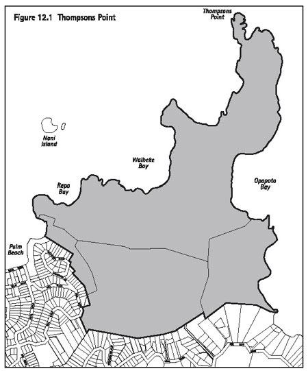
- Comprehensive development at Thompsons
Point (see figure 12.1) subject to compliance with the general rules
in clause 12.6 and the standards and terms in clause 12.9.7.3.
12.9.7.2 Assessment
matters
The council's assessment of an application for subdivision
in rural 2 will include consideration of the matters set out in clause
12.11. For comprehensive development at Thompsons Point, the specific
criteria in clause 12.12.4 will also be considered.
12.9.7.3 Standards
and terms
The following standards and terms apply:
- Subdivisions must meet the standards
for minimum areas specified in table 12.1: Minimum site areas for land
units; or
- Comprehensive development at Thompsons
Point (see figure 12.1):
- The subdivision must provide for sites
at an average of one site per 7.5ha of gross site area; and
- All sites created must have a minimum
area of 4.0ha, other than those sites created for the purpose of reserves,
public accessways or jointly owned access sites.
- The application must detail revegetation
on each proposed site. This must include an ongoing management programme
that specifies any protection and enhancement.
12.9.8 Rural
3
12.9.8.1 Provision
Subdivision in rural 3 is a discretionary activity subject
to compliance with the general rules in clause 12.6 and the standards
and terms in clause 12.9.8.3.
12.9.8.2 Assessment
matters
The council's assessment of an application for subdivision
in rural 3 will include consideration of the matters set out in clause
12.11 as well as the specific criteria contained in clause 12.12.5.
12.9.8.3 Standards
and terms
The following standards and terms apply:
- The relevant standards for site sizes
as set out in table 12.1: Minimum site areas for land units must be
met; and
- The subdivision must implement a
comprehensive revegetation programme which provides for revegetation
of 80 per cent of each proposed site.
12.9.9 Pakatoa
12.9.9.1 Provision
Comprehensive development in the Pakatoa land unit is
a discretionary activity subject to compliance with the general rules
in clause 12.6 and the standards and terms in clause 12.9.9.3.
12.9.9.2 Assessment
matters
The council's assessment of an application for comprehensive
development in the Pakatoa land unit will include consideration of the
matters set out in clause 12.11 as well as the specific criteria contained
in clause 12.12.6.
12.9.9.3 Standards
and terms
The following standards and terms apply:
- The existing tourist facility may be
subdivided into one title.
- Minimum site sizes:
- A minimum site area of 500m2
per dwelling may be approved where existing and/or proposed buildings
are clustered and have an equal undivided share in the balance area
of the island. The comprehensive development must incorporate residential
and/or visitor accommodation activities to maximum density of 50 dwellings
or visitor accommodation units; or
- A minimum site size of 0.5ha and
median site size of 1.5ha may be approved where a dispersed pattern
of buildings is proposed.
12.9.10 Matiatia
12.9.10.1 Provision
Comprehensive development in the Matiatia land unit
is a discretionary activity subject to compliance with the general rules
in clause 12.6 and the standards and terms in clause 12.9.10.3.
12.9.10.2 Assessment
matters
The council's assessment of an application for comprehensive
development in the Matiatia land unit will include consideration of
the matters set out in clause 12.11 as well as the specific criteria
contained in clause 12.12.7.
12.9.10.3 Standards
and terms
The comprehensive development must provide a minimum
site area of 2000m2 for a maximum of six sites.
12.9.11 Tryphena,
Medlands, Claris, Whangaparapara, Okupu, Awana, Okiwi and Port Fitzroy
settlement areas
12.9.11.1 Provision
Subdivision in the Tryphena, Medlands, Claris, Whangaparapara,
Okupu, Awana, Okiwi and Port Fitzroy settlement areas is a discretionary
activity subject to compliance with the general rules in clause 12.6
and the standards and terms in clause 12.9.11.3.
12.9.11.2 Assessment
matters
The council's assessment of an application for subdivision
in these settlement areas will include consideration of the matters
set out in clause 12.11 as well as the specific criteria contained in
clause 12.12.8.
12.9.11.3 Standards
and terms
The subdivision must meet the standards for minimum
areas specified in table 12.3: Minimum site areas for settlement areas.
12.10 Non-complying
activities
As shown in table 12.4: Activity table for all types
of subdivision, the following subdivisions are non-complying activities:
- Company leases and unit titles in all
land units and settlement areas that do not meet the general rules contained
in clause 12.6.3.
- Additional stages to an approved
subdivision consent, where the staging is not in general accordance
with the scope and terms of the original consent.
- Any subdivision which does not meet
the minimum site sizes specified in table 12.1: Minimum site areas for
land units, table 12.2: Minimum site areas for protecting significant
environmental features and table 12.3: Minimum site areas for settlement
areas.
- Any subdivision in the Aotea settlement
area.
- Any subdivision in parts of settlement
areas, where subdivision is identified as a non-complying activity in
table 12.3.
- Any subdivision in commercial 6,
commercial 7 or the Rotoroa land unit.
- Any subdivision in commercial 1-5,
recreation 1-3, the conservation land unit, rural 2, rural 3, the Pakatoa
and Matiatia land units, and the Tryphena, Medlands, Claris, Whangaparapara,
Okupu, Awana, Okiwi and Port Fitzroy settlement areas which does not
meet the general rules contained in clause 12.6 and/or the specific
standards and terms contained in clauses 12.9.3.3,
12.9.4.3, 12.9.5.3,
12.9.6.3, 12.9.7.3, 12.9.8.3,
12.9.9.3, 12.9.10.3 and
12.9.11.3.
- Any subdivision which is not specifically
provided for as a permitted, restricted discretionary or discretionary
activity.
12.11 General
assessment criteria for discretionary applications
Conditions may be imposed with regard to any of the
matters set out below and may include bonds, consent notices, covenants,
or similar measures to avoid remedy and/or mitigate any adverse effects.
The council's assessment of an application for a discretionary
activity will include consideration of the following matters:
12.11.1 Objectives
and policies
The extent to which the proposal is consistent with
the objectives and policies in:
- part 3 - Strategic management areas
- the relevant land unit, or settlement
area
- part 12 - Subdivision.
12.11.2 Low impact
design
The extent to which the subdivision provides for low
impact design that avoids, remedies and mitigates adverse effects on
the environment. The Hauraki Gulf Islands Development Code may be used
as a guide for achieving this outcome.
12.11.3 Reverse
sensitivity
The extent to which the proposed subdivision minimises
any potential for cross-boundary conflicts with regard to the land use
activities proposed for the site(s).
12.11.4 Land
suitable for rural production
The extent to which the site sizes and design of a proposed
site containing land for rural production retains as much of this land
around the building platform as practicable.
12.11.5 Site
design and layout
The extent to which the subdivision addresses site design
and layout by:
- Locating site boundaries so that associated
development protects and preserves elements, patterns and features that
contribute to the natural landscape character, visual amenity and amenity
value of each land unit or settlement area.
- Locating site boundaries so that
associated development can be visually integrated within the coastal
landscape without adversely affecting the natural character and amenity
value of the coastal environment and wider visual catchment.
- Locating site boundaries so that
they integrate with the topography and the usability of the site(s).
- Locating proposed site boundaries
so that they integrate and locate the building platforms in relation
to existing buildings and adjoining sites.
- Locating proposed site boundaries
so that they identify the likely location of buildings and accessways
in order to minimise potential visual impacts.
- Avoiding adverse effects on landscape
and visual amenity values within the wider visual catchment.
- Avoiding any non-compliance with
the rules associated with existing buildings. This includes considering
the extent to which subdivision is designed so that any level of non-compliance
that already exists is not increased.
- Ensuring that the layout of reserves
and accessways provides for adequate public access.
12.11.6 Access
to sites
- The extent to which the location and
design of any proposed pedestrian and vehicle accessways on the proposed
site(s) avoid or minimise any adverse effects on soil stability, natural
character, visual amenity and vegetation.
- The extent to which the proposed
sites are located and designed so that each site has either:
- A minimum frontage that provides for
practical, legal and safe access from a formed public road, that is
suitable for both normal road going vehicles and construction traffic;
or
- Legal foot access. This may be approved
where it is considered that legal vehicular access to a site is:
- Unnecessary; or
- Because of topographical features,
it is impracticable; or
- Where the site abuts the sea and
the council is satisfied that there is practicable access from the sea.
If the council approves sites with legal foot
access only, then such sites will be required to have this registered
on their titles through a consent notice or another suitable legal instrument.
- The extent to which the subdivision
provides for safe and practical pedestrian paths and cycle ways (whether
sealed or unsealed) that are located in a manner which connects, or
has the potential to connect to reserves (existing or proposed); the
coast; other water bodies and rural walkways.
- The extent to which the site design
minimises the impact of roading and access on the natural character
and landscape values of the coastal environment.
- The extent to which the site design
recognises the safety and efficiency of the roading network and the
appropriateness of the proposed roading pattern. This includes considering
the effect of any new intersections or private access ways on traffic
safety and efficiency, including unobstructed sight distances from intersections.
- The extent to which the site design
recognises any impact of roading and access on water bodies, ecosystems,
drainage patterns and other amenities.
- The extent to which the subdivision
provides for future roads to serve surrounding land or for road links
that need to pass through the subdivision.
- The extent to which there is/are
existing unformed legal road(s) contiguous with or within land subject
to subdivision, that are not required for future roading use.
Such roads may be closed under the Local Government
Act 1974 and consideration given to vesting them as reserve, transferring
ownership to adjacent administering bodies of reserves or offering them
for sale to adjacent landowners at market value. In the case of the
latter, the selection of buyer(s) and the terms of sale will be managed
by the council.
12.11.7 Natural
water systems
- The extent to which there is sufficient
capacity and treatment to provide for the safe and efficient disposal
of stormwater and wastewater from the subdivision and possible future
development.
- The extent to which the design of
stormwater and wastewater disposal systems incorporate measures to reduce
runoff rates where there may be damage caused to natural waterway systems.
- The extent to which any subdivision
proposal demonstrates how any natural water system on the site will
be managed, protected or enhanced.
12.11.8 Water
supply
- The extent to which the subdivision provides
for an adequate and reliable supply of potable water to each proposed
site. The requirements of the Hauraki Gulf Islands Development Code
may be used as a guide for achieving this outcome.
- The extent to which the subdivision
provides for an adequate and reliable supply of emergency water supply
to each site in the event of fire.
12.11.9 Stormwater
disposal
The extent to which there are adequate design measures
for collecting and disposing of stormwater from impervious surfaces.
The design must include measures that:
- Control any adverse effects of the proposed
subdivision relating to drainage onto or from adjoining sites or proposed
sites.
- Screen out water borne litter, siltation
and contamination before the stormwater reaches the boundary of any
site or of any proposed site or any body of water.
- Reduce runoff rates where there may be
damage caused to natural waterway systems.
12.11.10 Sewage
treatment and disposal
- The extent to which the subdivision has
sufficient capacity for the disposal of any effluent or other wastewater
flow within the boundaries of each proposed site regardless of seasonal
variations and loading (this may require an assessment of soil types,
and as necessary, percolation tests).
- Where more than one site will be
created, the extent to which a shared or individual wastewater treatment
and disposal system is considered the most appropriate, having regard
to any existing problems within the vicinity of the site.
- The extent to which easements and
consent notices may be applied to protect the integrity of wastewater
disposal systems.
12.11.11 Network
utility services
- The extent to which access easements
provide for lines, including electric lines, telecommunication lines
and other lines, where such lines or cables are or may be located within
any private property and serve other properties or sites.
- The extent to which sites can be
connected to services such as telecommunications and electricity.
- The extent to which cables must
be placed underground with minimal disturbance to the environment.
- The extent to which the provision
of utility services to any site is of an appropriate design for the
potential uses and the particular characteristics of the area.
- The extent to which the installation
of utility services does not adversely affect natural landscape and
amenity qualities.
12.11.12 Open
space, recreation and financial contributions
- The extent to which land and/or financial
contributions provide for open space and recreation that is consistent
with the objectives and policies of the Plan.
- The extent to which adverse effects
generated from the subdivision and associated development can be adequately
avoided, remedied, mitigated or off-set by providing works and services
on or off the site(s) and/or by paying or providing a financial contribution.
- The extent to which the subdivision
where possible, provides for public access to and alongside the coast,
streams, lakes and wetlands.
Notes:
- The council may require a report from
an appropriately qualified independent person to assess whether any
open space or recreational facilities provided as a financial contribution
(eg walkways) are in accordance with the consent conditions.
- The council's parks officers will be consulted
regarding the suitability and practicality of any proposed public reserves
or pedestrian linkages.
- All proposed reserves must be vested and
any easements created before titles are issued.
12.11.13 Protecting
vegetation and landscape
- The extent to which the natural features,
patterns and character of the landscape including but not limited to
ridgelines, headlands, dunes and wetlands are adversely affected.
- The extent to which the size and
shape of sites maximise the protection of indigenous vegetation.
- The extent to which the proposed
subdivision maximises the use of areas that are already cleared for
vehicle access and building sites.
- The extent to which the subdivision
provides for ecological restoration and enhancement where appropriate.
Ecological enhancement may include enhancement of existing indigenous
vegetation, replanting and weed and pest control.
12.11.14 Preserving
and enhancing heritage features
- The extent to which the subdivision and
subsequent land use on the proposed site(s) adversely affects the historical,
cultural or spiritual significance of any site or waahi tapu of significance
to iwi.
- The extent to which the subdivision
design and layout preserves and enhances areas of archaeological, cultural
or spiritual significance.
- The extent to which the landscape
integrity of the heritage feature(s) is maintained and enhanced.
12.11.15 Earthworks
and land disturbance
- The extent to which the earthworks can
be undertaken in a manner which mitigates and remedies adverse effects
from soil erosion and the generation of sediments into receiving environments.
- The extent to which the earthworks
are likely to have adverse effects on visual or other landscape qualities
which cannot be avoided, remedied or mitigated.
12.11.16 Natural
hazards
- The extent to which subdivision will
increase the risks associated with the natural hazard.
- The extent to which the subdivision
avoids, remedies or mitigates any hazard prone area.
- The extent to which the subdivision
modifies any natural defences against the hazard present.
- Where land adjoins the coastline,
the extent to which the following matters have been assessed:
- Coastal erosion.
- The identification of building platforms
that are located and designed to avoid interference with natural coastal
processes.
- The need for any coastal protection
works and methods to protect the subject land from coastal erosion.
The assessment must address the above matters
both in terms of effects at the time of subdivision and within a 50
year and 100 year time period.
12.11.17 Contaminated
land
- The extent to which contaminated or potentially
contaminated soil or ground water is able to be treated or disposed
of.
- The extent to which remediation
measures and methodologies can be employed to avoid, remedy or mitigate
any adverse effects on human health, water quality, and to the downstream
receiving environment.
- The extent to which the land is
suitable for its intended use.
- The extent to which consent notices
or other protective instruments are applied to ensure that remediation
measures and methodologies are implemented at the time of development.
Note: The council may require a land use consent under
to clause 12.6.1(2) and clause 9.6.3(1) so that remediation of land
is undertaken prior to the issuing of the titles.
12.12 Specific
assessment criteria for discretionary activities
12.12.1 Specific assessment
criteria for subdivisions to protect significant environmental
features
The council's assessment of an application for a discretionary
activity under clause 12.9.3 will include consideration of the following
matters:
- The extent to which the proposed sites
provide for buildings that will be visually integrated with the landscape,
as supported by a report from a landscape architect. The report must
assess the likely effects of development in relation to the landscape
character and amenity value of the site and wider visual catchment.
Particular regard must be made to the spatial extent of the significant
environmental feature(s), the pattern of regenerating indigenous vegetation,
low impact design, and placement of buildings within the natural landscape.
- The extent to which access to the
new sites is taken from any existing access or provided as a common
access in order to reduce visual and environmental effects, including
minimising earthworks and vegetation removal.
- The extent to which the elements,
patterns and features that contribute to the natural character of any
outstanding natural landscape(s) are preserved.
- The extent to which the site(s)
retains and enhances the feature(s) in its landscape context.
- The extent to which the feature(s)
determine the proposed site boundaries.
- The extent to which the feature(s)
determine the extent of legal protection.
12.12.2 Specific
assessment criteria for cluster subdivisions
The council's assessment of an application for a discretionary
activity under clause 12.9.4 will include consideration of the following
matters:
- The extent to which the sites created
avoid a linear form or repetitive patterns of buildings and infrastructure.
- The extent to which the proposed
sites provide for buildings that will be visually integrated with the
landscape, as supported by a report from a landscape architect. The
report must assess the likely effects of development in relation to
the landscape character and amenity value of the site and wider visual
catchment. Particular regard must be made to the spatial extent of the
significant environmental feature(s), the pattern of regenerating indigenous
vegetation, low impact design, and placement of buildings within the
natural landscape.
- The extent to which the elements,
patterns and features that contribute to the natural character of the
outstanding landscape(s) are preserved.
- The extent to which the subdivision
provides for appropriate on-site wastewater disposal and water supply
for each site. The provision of shared infrastructure servicing more
than one property is preferred in order to minimise environmental effects.
- The extent to which access to the
new sites is taken from any existing access or provided as a common
access in order to reduce visual and environmental effects, including
minimising earthworks and vegetation removal.
- As far as practicable, the extent
to which the proposed subdivision minimises the impact on any existing
or potential productive activities on the parent site.
- The extent to which appropriate
planting may be used to reduce potential visual effects. Such planting
will be subject to bonds and consent notices should consent be granted.
12.12.3 Specific
assessment criteria for subdivisions in commercial 1-5
The council's assessment of an application for a discretionary
activity under clause 12.9.5 will include consideration of the following
matters:
- The extent to which vehicle access to
each site is designed to:
- Avoid or mitigate traffic and associated
noise impacts upon any surrounding residential and recreational uses;
and
- Take advantage of any existing vehicle
access where this is practicable.
- The extent to which the subdivision
pattern encourages a vibrant and varied retail environment within the
Oneroa and Ostend villages.
12.12.4 Specific
assessment criteria for comprehensive development at Thompsons Point
(rural 2)
The council's assessment of an application for a discretionary
activity under clause 12.9.7 will include consideration of the following
matters:
- The extent to which the subdivision and
associated development preserves natural character and amenity values
of the land unit as supported by a report from a landscape architect.
Particular regard must be made to the pattern of indigenous vegetation,
productive rural land, low impact design, and placement of buildings
within the environment.
- The extent to which the subdivision
is likely to lead to buildings which are visually integrated within
the coastal landscape without adversely affecting the natural character
and amenity value of the coastal environment and wider visual catchment.
- The extent to which the natural
features, patterns and character of the landscape including but not
limited to ridgelines, headlands, dunes and wetlands are adversely affected
through inappropriate subdivision.
- The extent to which the proposed
subdivision facilitates the protection of productive soils and whether
it is likely to lead to cumulative impacts, adversely affecting such
potential productivity.
- The extent to which the proposed
subdivision provides for a successful indigenous revegetation programme
as supported by a report by a landscape advisor. The programme must
include:
- A detailed landscape plan, including
an implementation and maintenance programme.
- Details of the plant sizes at the
time of planting and intended species.
- The extent to which legal protection
of landscape values (including revegetation) is proposed as part of
the subdivision application and the nature and extent of the protective
legal instruments.
12.12.5 Specific
assessment criteria for subdivisions in rural 3
The council's assessment of an application for a discretionary
activity under clause 12.9.8 will include consideration of the following
matters:
- The extent to which the subdivision and
associated development preserves visual amenity and the landscape character
of the land unit. Particular regard must be made to the pattern of regenerating
indigenous vegetation, low impact design, and placement within the coastal
environment.
- The extent to which the proposed
subdivision provides for a successful indigenous revegetation programme
of 80 per cent of the proposed site(s) as supported by a report prepared
by a landscape advisor. The programme must include:
- A detailed landscape plan, including
an implementation and maintenance programme.
- Details of the plant sizes at the
time of planting and intended species.
- The extent to which any conditions,
covenant, bonds or similar measures have been proposed or are needed
to facilitate revegetation.
12.12.6 Specific
assessment criteria for comprehensive development on Pakatoa
The council's assessment of an application for a discretionary
activity under clause 12.9.9 will include consideration of the following
matters:
- The extent to which the proposal provides
for development that will be visually integrated with the landscape,
as supported by a report from a landscape architect. The report must
assess the effects of the development in relation to the landscape character
and amenity value of the island and wider visual catchment.
- The extent to which the subdivision
is likely to lead to buildings which are visually integrated within
the coastal landscape without adversely affecting the natural character,
amenity value of the coastal environment and wider visual catchment.
- The extent to which protection and
enhancement of landscape values is proposed as part of the subdivision
application and the nature and extent of the protective legal instruments.
12.12.7 Specific
assessment criteria for comprehensive development at Matiatia
The council's assessment of an application for a discretionary
activity under clause 12.9.10 will include consideration of the following
matters:
- The extent to which the site design promotes
a coherent and integrated layout that reflects the character and identity
of the harbour.
- The extent to which the site design
provides for the safe and efficient circulation of vehicular traffic
that is integrated with the internal road network, adjoining open spaces
and associated development.
- The extent to which the site design
provides for safe and convenient pedestrian linkages and other pedestrian
amenities.
- The extent to which car parking
areas adversely affect the streetscape and/or open areas, particularly
along the coastal edge.
- The extent to which the site design
provides for open space that is accessible to the public and maintains
and enhances views.
- The extent to which the site design
maintains and enhances views of the harbour and to other natural landscape
features.
12.12.8 Specific
assessment criteria for subdivisions in settlement areas
The council's assessment of an application for a discretionary
activity under clause 12.9.11 will include consideration of the following
matters:
- The extent to which any covenants or
similar measures have been proposed or are needed to facilitate revegetation
and protect any significant environmental, historic or archaeological
features.
- The extent to which the proposed
site design reflects natural landforms, retains bush areas, open space
areas and protects riparian areas.
- The extent to which the subdivision
provides sufficient means to mitigate adverse effects that arise from
earthworks, vegetation removal, and disposal of wastewater.
- The extent to which the use of a
shared wastewater disposal system has been investigated.
- The extent to which proposed site
boundaries recognise the relationship and orientation of existing sites
so that an attractive edge between developments in adjoining land units
and settlement areas is fostered.
12.13 Esplanade
reserves
12.13.1 Requirement
for an esplanade reserve or esplanade strip
Where any site of less than 4ha is created when land
is subdivided, the RMA requires an esplanade reserve 20m in width to
be set aside from that site along the mark of mean high water springs
of the sea, and along the bank of any river whose bed has an average
width of 3m or more, or along the margin of any lake whose bed has an
area of 8ha or more.
Esplanade reserves are subdivided with fixed boundaries
and are owned by the council. Esplanade strips are created by instruments
on the title of the land, remain in private ownership and have boundaries
that move with any changes resulting from erosion or accretion. An esplanade
reserve or esplanade strip will generally be 20m wide.
The RMA provides for rules to be included in a Plan
providing for the width of an esplanade reserve or esplanade strip to
be increased or decreased or waived under certain circumstances (section
77 of the RMA). The nature of the coastline and rivers of the islands
is such that it is desirable that the provisions of the RMA are used
to their fullest extent. However, it is recognised that there may be
circumstances where an increase, reduction or waiver of the esplanade
requirements could be justified.
The council may require a width greater than 20m to
be vested as an esplanade reserve or esplanade strip, where there are
significant conservation or recreational benefits, or to mitigate natural
hazards, or to improve public access. When an esplanade reserve or esplanade
strip greater than 20m is required the council will compensate for the
extra land in accordance with the requirements of the RMA.
Where a site of 4ha or more is to be formed through
subdivision, an esplanade reserve or esplanade strip will be required
where the land concerned is demonstrably significant for the protection
of conservation values, recreational use, public access, or for the
mitigation of natural hazards, and its width will be determined accordingly.
In such a case, the council may compensate for the esplanade reserve
or esplanade strip in accordance with the requirements of the RMA.
The decision on the most appropriate method of achieving
the Plan's objectives, and policies, either by setting aside esplanade
reserves or by creating esplanade strips upon subdivision will depend
on the circumstances and the purpose for which the land is required.
Esplanade strips are appropriate to protect areas with
the following characteristics:
- land instability
- moderate or low conservation values
- where public access should be restricted
- land can be left in private ownership
without detriment to the natural coastal environment or watercourses.
The council will make use of the provisions of section
237B of the RMA to enable access to be obtained to present and future
esplanade reserves and esplanade strips.
The council may require an esplanade reserve or esplanade
strip as part of a land use consent which does not involve any form
of subdivision. Such a requirement is subject to part 6 - Financial
contributions.
12.13.2 Rules
- Where any site of 4ha or less is created,
an esplanade reserve 20m in width must be set aside from that site along
the mark of mean high water springs of the sea, and along the bank of
any river whose bed has an average width of 3m or more, or along the
margin of any lake whose bed has an area of 8ha or more, except that:
- The requirement for an esplanade reserve
may be met by the creation of an esplanade strip (in accordance with
section 232 of the RMA).
An application seeking to provide an esplanade
strip rather than an esplanade reserve must be made by way of an application
for a restricted discretionary activity that must be submitted together
with any subdivision application. The council has restricted its discretion
to considering the matters listed in clause 12.13.3.
- An application can be made to reduce,
waive, vary or cancel the rules requiring provision for esplanade reserves
or esplanade strips by way of an application for a discretionary activity
that must be submitted together with any subdivision application. The
council's assessment of an application for a discretionary activity
to reduce, waive, vary or cancel an esplanade reserve or esplanade strip
will include consideration of the matters contained in clause 12.13.4.
- Where a site of 4ha or more is to
be created, an esplanade reserve or esplanade strip will be required
only when the land concerned is demonstrably important for the protection
of conservation values, recreation or public access or for the mitigation
of natural hazards. The council's assessment as to whether such an esplanade
reserve or esplanade strip should be required will include consideration
of the matters contained in clause 12.13.5.
- An esplanade reserve or esplanade
strip can be increased to a width greater than 20m to satisfy the purposes
of section 229 of the RMA. The council's assessment as to whether the
width should be increased will include consideration of the matters
contained in clause 12.13.6.
- All applications for subdivision
of land along the mark of mean high water springs of the sea, and along
the bank of any river whose bed has an average width of 3m or more,
or along the margin of any lake whose bed has an area of 8ha or more
must clearly indicate the location and extent of the esplanade reserve.
- Any building located within an area
to be vested as esplanade reserve may be required to be vested in the
council or removed at the owner's expense prior to vesting.
- On the stopping of any road, adjacent
to the mark of mean high water springs of the sea, under the Local Government
Act 1974, the stopped road will become a local purpose (esplanade) reserve;
provided that the council may reduce the width of such a reserve to
not less than 20m at any one point.
- Land vested as an esplanade reserve
or set aside as an esplanade strip will be considered as part of the
gross site area for the purposes of assessing site size for subdivision,
and for applying the building coverage and impervious surface controls.
- The yard requirements of the Plan
will continue to apply unless those yards have been reduced by means
of a resource consent.
- Any boundary of a esplanade reserve
or esplanade strip reduced in accordance with the criteria will not
necessarily be limited to a consistent or uniform distance from the
mark of mean high water springs of the sea, river, or lake but may be
varied to include features of importance for achieving the purposes
of esplanade reserves or esplanade strips.
- The council may, in granting a
waiver of an esplanade reserve require an esplanade strip to be provided.
- To enable access to be obtained
to present and future esplanade reserves and esplanade strips the council
will make use of the provisions of section 237B of the RMA
12.13.3 Matters
of discretion for considering an esplanade strip rather than an esplanade
reserve
Where an application seeks to provide an esplanade strip
rather than an esplanade reserve, the council has restricted its discretion
to the following matters:
- The extent to which the proposed esplanade
strip includes land which is subject to instability, flooding, or coastal
erosion.
- The extent to which the proposed
esplanade strip includes land which has moderate or low conservation
values.
- The extent to which it is appropriate
to restrict public assess to the land subject to proposed esplanade
strip.
- The extent to which the proposed
esplanade strip includes land which can be left in private ownership
without detriment to the natural coastal environment and watercourses.
12.13.4 Specific
assessment criteria for reducing, waiving, cancelling or varying an
esplanade area
The council's assessment of an application for a discretionary
activity to reduce, waive, vary or cancel an esplanade reserve or esplanade
strip will include consideration of the following matters:
- The extent to which the proposed reduction
in the width or waiver of the esplanade reserve or esplanade strip meets
the objectives and policies of the Plan in respect of the conservation
and enhancement of the coastal environment and, in particular:
- The protection and/or enhancement of
the natural functioning of the adjacent sea, river or lake.
- The protection and/or enhancement
of terrestrial or aquatic habitats.
- The mitigation of any actual or
potential natural hazard.
- The protection of natural values
associated with the water body, including protection of flora and fauna,
wildlife habitats and natural landscape amenity values.
- The extent to which there are significant
ecological characteristics of the land that contribute to the protection
and enhancement of the natural functioning of the adjacent sea, river
or lake and the terrestrial and aquatic habitats that are present in
the proposed esplanade reserve or esplanade strip.
- The extent to which any areas of
actual or potential natural hazards are included in the proposed esplanade
reserve or esplanade strip in order to mitigate against natural hazards.
- The extent to which public access
to and along the sea or river or waterway is enabled or diminished particularly,
if access is to be located on steep topography.
- The extent to which public safety
or security is improved.
- The extent to which the recreational
use of the proposed esplanade reserve or esplanade strip and adjacent
water area is enabled or diminished.
- The extent to which the proposed
esplanade reserve or esplanade strip is compatible with the physical
characteristics of the land.
- The extent to which the natural
character and visual quality of the coastline, river or lake will be
preserved within the proposed esplanade reserve or esplanade strip.
- The extent to which the use of conservation
covenants or other suitable alternative means would achieve the objectives
and policies of the Plan.
- The extent to which there are any
natural values associated with the proposed esplanade reserve or esplanade
strip of significance to the tangata whenua.
- The extent to which there are any
significant archaeological or historical sites associated with the proposed
esplanade reserve or esplanade strip.
- The extent to which any existing
permanent building should be excluded from the proposed esplanade reserve
or esplanade strip or be removed or relocated prior to vesting of the
esplanade reserve or setting aside the esplanade strip.
- The extent to which the application
is for a minor boundary adjustment that will not create further building
sites.
- The extent to which other unusual
or unique circumstances exist such that it would not be appropriate
to require a esplanade reserve or esplanade strip.
- The extent to which the purposes
of the esplanade reserve or esplanade strip specified in section 229
of the RMA are not significantly diminished.
- The extent to which any existing
or future buildings dominate or shadow the proposed esplanade reserve
or esplanade strip.
12.13.5 Guidelines
for requiring an esplanade area for sites of 4ha or more
The council will use the following guidelines when considering
whether to require an esplanade reserve or esplanade strip for sites
of 4ha or more:
- The extent to which the esplanade reserve
or esplanade strip would have demonstrable significance for the protection
of conservation values, in particular:
- The protection or enhancement of the
natural functioning of the adjacent sea, river or lake.
- The protection or enhancement of
terrestrial habitats.
- The mitigation of any actual or
potential natural hazards.
- The protection of natural values
associated with the water body, including protection of flora and fauna,
wildlife habitats and natural landscape amenity values.
- The extent to which recreational
use of the esplanade reserve or esplanade strip and adjacent water area
would be enabled or enhanced.
- The extent to which public access
to and along the sea, river or lake is enabled or enhanced.
- The extent to which there are significant
archaeological or historical sites within the proposed esplanade reserve
or esplanade strip.
- The extent to which there are natural
values of significance to the tangata whenua associated with the esplanade
reserve or esplanade strip.
The provisions of section 237F of the RMA outline matters
of compensation. Alternatively, any esplanade area that requires compensation
in accordance with section 237E(2) of the RMA can be used as part of
the financial contribution required by part 6 - Financial contributions.
12.13.6 Guidelines
for increasing the width of an esplanade area
The council will use the following guidelines when considering
whether an esplanade area width should be increased above 20m:
- The extent to which there is a demand
for recreational use of the land over and above what can be achieved
with a 20m wide esplanade reserve or esplanade strip.
- The extent to which access to an
existing or possible future esplanade reserve or esplanade strip can
be enhanced.
- The extent to which there are outstanding
conservation values that warrant recognition by way of a wider esplanade
reserve or esplanade strip.
- The extent to which the land is
located within a known natural hazard area.
An esplanade reserve or esplanade strip greater than
20m requires the council to purchase the extra land in accordance with
section 237E(2) of the RMA. Alternatively, any esplanade area that requires
compensation in accordance with section 237E(2) of the RMA can be used
as part of the financial contribution required by part 6 - Financial
contributions.
Table 12.1: Minimum site areas for land
units
| Land
units |
Minimum
site area |
| Landform 1 and 2 |
25ha |
| Landform 3 |
3.5ha |
| Landform 4-7 |
25ha |
| Island residential 1
and 2 |
2000m2 |
| Commercial 1-5 |
1500m2 and special
rules apply, see clause 12.9.5 |
| Commercial 6-7 |
NC |
| Matiatia |
Special rules apply, see clause
12.9.10 |
| Recreation 1-3, conservation |
Special rules apply, see clause
12.9.6 |
| Rural 1 |
5ha |
| Rural 2 |
25ha or special rules apply, see
clause 12.9.7 |
| Rural 3 |
3ha and special rules apply, see
clause 12.9.8 |
| Pakatoa |
Special rules apply, see clause
12.9.9 |
| Rotoroa |
NC |
Legend
NC = Non-complying. Subdivision is not provided for
in this land unit.
Note:
- All site areas are net site areas.
Table 12.2: Minimum site areas for protecting
significant environmental features
| Land
units |
Minimum
site area |
Minimum
average site area |
| Landform 2 |
4ha |
7.5ha |
| Landform 3 |
1.5ha |
2ha |
| Landform 4-7 |
4ha |
7.5ha |
| Rural 1 |
1.5ha |
2ha |
Notes:
- All site areas are net site areas.
- Subdivision for protecting significant
environmental features is provided for only in the land units listed
in table 12:2.
Table 12.3: Minimum sites areas for settlement
areas - Great Barrier (refer clause 12.9.11)
| Settlement
area |
Minimum
site area |
Minimum
average site area |
| Tryphena (local retailing
area) |
1500m2 |
1500m2 |
| Tryphena (headland protection
and residential amenity areas) |
3000m2 |
7000m2 |
| Tryphena (Mulberry Grove
School, reserves and coastal margin areas) |
NC |
NC |
| Medlands (residential
amenity area) |
2000m2 |
2000m2 |
| Medlands (quarry, dune
and wetland conservation areas) |
NC |
NC |
| Claris (local retailing
area) |
1500m2 |
1500m2 |
| Claris (residential
amenity area) |
1500m2 |
2000m2 |
| Claris (light industry
area) |
2000m2 |
2000m2 |
| Claris (airport, dune
and wetland conservation areas) |
NC |
NC |
| Okupu (residential amenity
area) |
2000m2 |
2000m2 |
| Okupu (reserve and dune
protection area) |
NC |
NC |
| Whangaparapara (residential
amenity and visitor accommodation areas) |
2000m2 |
3000m2 |
| Awana (residential amenity
area) |
2000m2 |
2000m2 |
| Okiwi (local retailing
area) |
1500m2 |
1500m2 |
| Okiwi (residential amenity
area) |
2000m2 |
4000m2 |
| Okiwi (Okiwi school
and domain area) |
NC |
NC |
| Port Fitzroy (residential
amenity area) |
5000m2 |
7000m2 |
| Port Fitzroy (local
retailing area) |
1500m2 |
1500m2 |
| Aotea |
NC |
NC |
Legend
NC = Non-complying. Subdivision is not provided for
in this area.
Note:
- All site areas are net site areas.
Table 12.4: Activity table for all types of subdivision
| Land
units and settlement areas |
L1-7
|
IR1,
IR2 |
C1-5 |
C6 |
C7 |
M |
Rc1-3,
Cn |
Ru1 |
Ru2 |
Ru3 |
Pk |
Rt |
SA
1-8 |
SA
9 |
| Amendments to cross leases, unit
titles, company lease plans to show additions and alterations to buildings
and exclusive use areas by owner or owners. |
P |
P |
P |
P |
P |
P |
P |
P |
P |
P |
P |
P |
P |
P |
| Leases, including renewals, for
less than 35 years for sites which have complying or approved activities. |
P |
P |
P |
P |
P |
P |
P |
P |
P |
P |
P |
P |
P |
P |
| Unit titles, company leases. |
RD |
RD |
RD |
RD |
RD |
RD |
RD |
RD |
RD |
RD |
RD |
RD |
RD |
RD |
| Additional stage to an approved
subdivision consent where the staging is in general accordance with
the scope and terms of the original consent. |
RD |
RD |
RD |
RD |
RD |
RD |
RD |
RD |
RD |
RD |
RD |
RD |
RD |
RD |
| Leases, including renewals, for
longer than 35 years for sites which have complying or approved activities. |
RD |
RD |
RD |
RD |
RD |
RD |
RD |
RD |
RD |
RD |
RD |
RD |
RD |
RD |
| Boundary relocations where the
site sizes stay the same and no additional non-compliances in terms
of the permitted activity standards result. |
RD |
RD |
RD |
RD |
RD |
RD |
RD |
RD |
RD |
RD |
RD |
RD |
RD |
RD |
| Creation of rights of way including
those which do not meet the general rule in clause 12.6.1(1). |
RD |
RD |
RD |
RD |
RD |
RD |
RD |
RD |
RD |
RD |
RD |
RD |
RD |
RD |
| Subdivisions including cross leases
in L1-7, IR1, IR2 and Ru1 where the proposed site complies with
table
12.1 and the general rules in clause 12.6. |
RD |
RD |
n/a |
n/a |
n/a |
n/a |
n/a |
RD |
n/a |
n/a |
n/a |
n/a |
n/a |
n/a |
| Boundary relocations where the
site sizes do not stay the same and/or additional non-compliances in
terms of the permitted activity standards result. |
D |
D |
D |
D |
D |
D |
D |
D |
D |
D |
D |
D |
D |
D |
| Subdivisions including cross leases
in L1-7, IR1, IR2 and Ru1 where the area of the proposed site complies
with table 12.1 but does not meet the general rules in
clause12.6. |
D |
D |
n/a |
n/a |
n/a |
n/a |
n/a |
D |
n/a |
n/a |
n/a |
n/a |
n/a |
n/a |
| Special purpose sites. |
D |
D |
D |
D |
D |
D |
D |
D |
D |
D |
D |
D |
D |
D |
| Subdivision to protect a significant
environmental feature which meets the general rules in clause 12.6 and
the standards and terms in clause 12.9.3.3. |
D (n/a in L1)
|
n/a |
n/a |
n/a |
n/a |
n/a |
n/a |
D |
n/a |
n/a |
n/a |
n/a |
n/a |
n/a |
| Cluster subdivision which meets
the general rules in clause 12.6 and the standards and terms in
clauses
12.9.3.3 and 12.9.4.3. |
D (n/a in L1)
|
n/a |
n/a |
n/a |
n/a |
n/a |
n/a |
D |
n/a |
n/a |
n/a |
n/a |
n/a |
n/a |
| C1-5 subdivisions which meet the
general rules in clause 12.6 and the standards and terms in
clause 12.9.5.3. |
n/a |
n/a |
D |
n/a |
n/a |
n/a |
n/a |
n/a |
n/a |
n/a |
n/a |
n/a |
n/a |
n/a |
| Rc1-3, Cn subdivisions which meet
the general rules in clause 12.6 and the standards and terms in
clause
12.9.6.3. |
n/a |
n/a |
n/a |
n/a |
n/a |
n/a |
D |
n/a |
n/a |
n/a |
n/a |
n/a |
n/a |
n/a |
| Ru2 subdivisions (including comprehensive
develop-ment) which meet the general rules in clause 12.6 and the standards
and terms in clause 12.9.7.3. |
n/a |
n/a |
n/a |
n/a |
n/a |
n/a |
n/a |
n/a |
D |
n/a |
n/a |
n/a |
n/a |
n/a |
| Ru3 subdivisions which meet the
general rules in clause 12.6 and the standards and terms in
clause 12.9.8.3. |
n/a |
n/a |
n/a |
n/a |
n/a |
n/a |
n/a |
n/a |
n/a |
D |
n/a |
n/a |
n/a |
n/a |
| Pk comprehensive development which
meets the general rules in clause 12.6 and the standards and terms in
clause12.9.9.3. |
n/a |
n/a |
n/a |
n/a |
n/a |
n/a |
n/a |
n/a |
n/a |
n/a |
D |
n/a |
n/a |
n/a |
| M comprehensive development which
meets the general rules in clause 12.6 and the standards and terms in
clause 12.9.10.3. |
n/a |
n/a |
n/a |
n/a |
n/a |
D |
n/a |
n/a |
n/a |
n/a |
n/a |
n/a |
n/a |
n/a |
| Subdivisions in SA 1-8 which meet
the general rules in clause 12.6 and the standards and terms in
clause
12.9.11.3. |
n/a |
n/a |
n/a |
n/a |
n/a |
n/a |
n/a |
n/a |
n/a |
n/a |
n/a |
n/a |
D1 |
n/a |
| Any subdivision including cross
leases which does not comply with the minimum site sizes in tables 12.1,
12.2 and 12.3. |
NC |
NC |
NC |
NC |
NC |
NC |
NC |
NC |
NC |
NC |
NC |
NC |
NC |
NC |
| Any proposed subdivision in SA
9, C6, C7, Rt. |
n/a |
n/a |
n/a |
NC |
NC |
n/a |
n/a |
n/a |
n/a |
n/a |
n/a |
NC |
n/a |
NC |
| Any subdivision within C1-C5,
M, Rc1-3, Cn, Ru2, Ru3, Pk and SA 1-8 which does not meet the general
rules in clause 12.6 and/or the specific standards and terms in
clauses
12.9.3.3, 12.9.4.3, 12.9.5.3,
12.9.6.3, 12.9.7.3, 12.9.8.3,
12.9.9.3,
12.9.10.3 and 12.9.11.3. |
n/a |
n/a |
NC |
n/a |
n/a |
NC |
NC |
n/a |
NC |
NC |
NC |
n/a |
NC |
n/a |
| Company leases and unit titles
in all land units that do not meet the general rules in clause 12.6.3.
|
NC |
NC |
NC |
NC |
NC |
NC |
NC |
NC |
NC |
NC |
NC |
NC |
NC |
NC |
| Additional stages to an approved
subdivision consent, where the staging is not in general accordance
with the scope and terms of the original consent.
|
NC |
NC |
NC |
NC |
NC |
NC |
NC |
NC |
NC |
NC |
NC |
NC |
NC |
NC |
Notes:
- As identified in table 12.3, subdivision
is a non-complying activity in some parts of settlement areas.
- Any subdivision which is not a permitted,
restricted discretionary or discretionary activity in the rules is a
non-complying activity.
Legend:
| n/a - not applicable |
L1 - Landform 1 (coastal cliffs
and slopes) |
Rc1 - Recreation 1 (local parks
and esplanade reserves) |
| P - Permitted |
L2 - Landform 2 (dune systems
and sand flats) |
Rc2 - Recreation 2 (community
facilities and sports parks) |
| RD - Restricted discretionary |
L3 - Landform 3 (alluvial flats) |
Rc3 - Recreation 3 (Rangihoua
Park) |
| D - Discretionary |
L4 - Landform 4 (wetland systems) |
Cn - Conservation |
| NC - Non-complying |
L5 - Landform 5 (productive land) |
Ru1 - Rural 1 (rural amenity) |
| |
L6 - Landform 6 (regenerating
slopes) |
Ru2 - Rural 2 (western landscape) |
| |
L7 - Landform 7 (forest and bush) |
Ru3 - Rural 3 (Rakino) |
| |
IR1 - Island residential 1 (traditional
residential) |
Pk - Pakatoa |
| |
IR2 - Island residential 2 (bush
residential) |
Rt - Rotoroa |
| |
C1 - Commercial 1 (local shops) |
SA1 - Tryphena settlement area
|
| |
C2 - Commercial 2 (Ostend village) |
SA2 - Medlands settlement area
|
| |
C3 - Commercial 3 (local shops) |
SA3 - Claris settlement area
|
| |
C4 - Commercial 4 (visitor facilities) |
SA4 - Okupu settlement area |
| |
C5 - Commercial 5 (industrial) |
SA5 - Whangaparapara settlement
area
|
| |
C6 - Commercial 6 (quarry) |
SA6 - Awana settlement area
|
| |
C7 - Commercial 7 (wharf) |
SA7 - Okiwi settlement area
|
| |
M - Matiatia (mixed use) |
SA8 - Port Fitzroy settlement
area
|
| |
|
SA9 - Aotea settlement area
|