District Plan Hauraki Gulf Islands Section - Proposed 2006
(Notified version 2006)
Street index |
Planning maps |
Text |
Appendices |
Annexures |
Section 32 material |
Plan modifications |
Help |
Notified - Home |
Decision - Home
Part 10c - Development controls for land units and settlement areas
10c.1 Introduction
10c.2 Objectives
10c.3 Development control modifications
10c.4 Controls on the bulk, location and colour of buildings
10c.5 Controls for conservation and amenity
10c.1 Introduction
This section sets out the development controls for activities
for all land units and settlement areas. It also contains some controls
applying to vegetation on legal roads. The development controls in this
part relate to the scale, form and intensity of buildings and the resulting
effects on the environment, as well as conservation and amenity issues.
Those development controls which are readily quantified are summarised
in tables 10c.1 to 10c.6: Development controls which must be read in
conjunction with the relevant rule. Each of the rules in this part of
the Plan is accompanied by a brief explanation of the rule's purpose
and of the standards which are set. These statements outline the principal
reasons for the rules and should not be regarded as comprehensive.
Unless otherwise stated, the development controls in
this part apply to all land units and settlement areas. The development
controls apply to all activities whether or not those activities are
otherwise permitted, restricted discretionary, discretionary or non-complying.
Infringements to the development controls will be considered as development
control modifications under clause 10c.3.
Note: In addition to the controls contained in this
part, there are additional development controls for some land units
and settlement areas in part 10a - Land units: objectives, policies
and activity tables and part 10b - Settlement areas: objectives, policies
and activity tables. It is necessary to refer to these as well as this
part of the Plan.
10c.2 Objectives
- To recognise and provide for a broad
and flexible range of development while protecting the amenity values
of neighbouring properties and the character of the surrounding environment.
- To ensure that buildings and activities
which do not comply with the development controls are reasonably consistent
with the intent of the controls that they infringe (as set out in the
explanation accompanying the relevant development controls).
- To provide for a broad and flexible
range of development, while sustainably managing the effects of land
use on the natural environment.
10c.3 Development
control modifications
10c.3.1 Discretionary
activities
Unless otherwise specified an application to infringe
one or more of the development controls in this part, or in part 10a - Land units: objectives, policies and activity tables or part 10b -
Settlement areas: objectives, policies and activity tables is a discretionary
activity.
Assessment criteria
The council's assessment of an application for a development
control modification under this rule will include consideration of the
following matters:
- Whether allowing the infringement is
consistent with the objectives in clause 10c.2.
- Whether the infringement(s) will
result in any adverse effects on amenity values of neighbouring properties,
the character of the surrounding environment or the natural environment
which cannot be avoided, remedied or mitigated.
- Whether the development remains
consistent with the intention of the development control(s) it infringes
having regard to explanation given in the Plan for the particular control(s).
- The extent to which there will be
adverse cumulative effects where a development infringes two or more
development controls.
10c.3.2 Notification
requirements for restricted discretionary activities
In some instances this part of the Plan specifies that
an infringement of a particular development control is a restricted
discretionary activity. Within this part of the Plan, except as provided
for by section 94C(2) of the RMA, applications for a resource consent
for restricted discretionary activities will be considered without public
notification or the need to obtain written approval of or serve notice
on affected persons (in accordance with section 94D(2) and (3) of the
RMA).
10c.4 Controls
on the bulk, location and colour of buildings
10c.4.1 Height
- Any building must not exceed the height
specified in tables 10c.1 to 10c.6: Development controls for the relevant
land unit or settlement area.
- Methodology: the height of a building
is measured in accordance with the definition of height contained in
part 14 - Definitions.
Explanation
A maximum height limit for buildings is imposed to ensure
that buildings are of a scale which avoids the effects of overshadowing,
visual dominance, reduced privacy and diminished character. A range
of height limits have been set to reflect the physical qualities, characteristics
and aesthetic coherence of the relevant land units and settlement areas.
In addition to height limits there are special controls relating to
the location of buildings on or near significant ridgelines (see clause
10c.4.7).
10c.4.2 Height
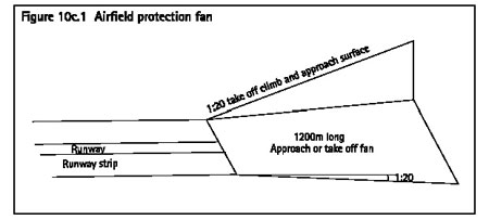
restrictions within the Claris and Okiwi airfield protection fans
The following is a prohibited activity:
- Any building, structure, mast, pole, tree
or other object which penetrates any of the takeoff climb and approach
protection fans for Claris or Okiwi airfields.
- The location of the protection fans is identified on
the planning maps (map references 42-13 for Okiwi, and 54-15 for Claris)
and is further detailed in figure 10c.1: Airfield protection fan.
Explanation
The purpose of these restrictions is to provide for
safe and unobstructed access to the runways at Claris and Okiwi airfields.
The extent of the airfield protection fans is consistent with civil
aviation regulations. The prohibited activity status is in recognition
of the fact that the airfield protection fans should never be obstructed
in any circumstances as this would compromise the safety and operation
of the airfields.
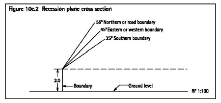
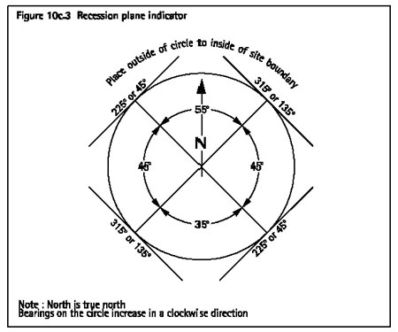
10c.4.3 Building in relation to boundary
- Any building must not exceed a height
equal to the recession plane angle shown in figure 10c.2: Recession
plane cross section.
- Exceptions: in addition to (1) above
the building in relation to boundary control does not apply to:
- Common boundaries in commercial 1, 2,
3 and 5.
- The commercial 7 and Matiatia land
units.
- Common boundaries within the following
parts of the settlement areas:
- local retailing areas
- Claris light industry area
- Claris airport area
- Medlands quarry area
- visitor accommodation area.
- Methodology:
- This control is determined using the
diagrams in figure 10c.2: Recession plane cross section and
figure 10c.3:
Recession plane indicator and is taken from a maximum height of 2m above
the ground level at the boundary for all land units and settlement areas,
with the exception of the land units and settlement areas noted in (2)
above.
- To determine the maximum building
height in relation to boundaries on the site, the diagram in
figure 10c.3: Recession plane indicator must be viewed within the site and
oriented north.
- The angle of inclination relative
to a particular boundary is determined by the angle on the diagram in
figure 10c.2: Recession plane cross section adjacent to that boundary.
Explanation
The building in relation to boundary rule is imposed
principally to ensure that a reasonable degree of sunlight is admitted
to adjacent sites. The admission of light to living and working areas
is desirable for public health and people's sense of wellbeing. It also
maintains an ability to use sunlight as a renewable energy source through
solar receptacles and enables the creation of sunny outdoor spaces and
provides a means for passive solar heating of buildings. The building
in relation to boundary rule is also imposed to control the visual dominance
of buildings, and to retain privacy on adjacent sites.
10c.4.4 Yards
- Any building or part of a building must
not be located in the front, side or rear yard specified in
tables 10c.1 to 10c.6: Development controls for the relevant land unit or settlement
area.
- Methodology: yards will be measured
on the horizontal plane from the site boundaries.
Explanation
Side and rear yards are controlled principally to ensure
that built development will not adversely impact upon the privacy and
amenity values of adjacent sites, and the character of an area. Front
yards principally ensure that streetscape amenity is maintained. Yards
also provide space for landscaping and underground services.
10c.4.5 Building
coverage
- Any building on a site must not exceed
the building coverage limits specified in tables 10c.1 to
10c.6: Development
controls for the relevant land unit or settlement area.
- Methodology: unless otherwise stated,
building coverage is measured as a percentage of the net site area.
Explanation
The principal reason for controlling building coverage
on a site is to limit the scale and intensity of development. Buildings
which do not comply with the building coverage control can appear overly
dominant, adversely affecting amenity values and reducing the character
of an area. Building coverage controls also assist in maintaining an
adequate area for on-site effluent disposal and in conjunction with
impervious surface controls ensure that the adverse environmental effects
from stormwater runoff are avoided. Limiting building coverage also
maintains an appropriate level of private open space and provides opportunities
for the planting of vegetation around buildings.
10c.4.6 Building
footprint
Any building on a site must not exceed the maximum building
footprint specified in tables 10c.1 to 10c.6: Development controls for
the relevant land unit or settlement area.
Explanation
In some land units and settlement areas, a limit has
been placed on the maximum size of any building. The control applies
in addition to the building coverage control. The principal reason for
this control is keep individual buildings to a suitable scale. It prevents
the permitted building coverage from being massed in one location to
create one or several large buildings which do not integrate readily
into the landscape.
10c.4.7 Ridgeline
control
Any building within a significant ridgeline area identified
on the planning maps must be constructed and located so that:
- The building is below the significant
ridgeline at that point; or
- The building is below the top of
protected vegetation (located on the same site as the building) that
either screens the building or forms a backdrop against the ridgeline
at that point.
Protected vegetation means any vegetation that is protected
by:
- The indigenous vegetation protection rules
in clause 10c.5.1; or
- The exotic tree protection rules in clause
10c.5.2; or
- A legal covenant with council under the
Land Transfer Act 1952.
Explanation
Buildings that protrude above significant ridgelines
can compromise the visual landscape qualities of the ridge and appear
visually obtrusive giving rise to adverse visual effects. The location
and height of buildings within 100m either side of a significant ridgeline
is therefore controlled to manage the adverse visual impact that can
occur when a building protrudes above the ridgeline.
10c.4.8 Colour
of building materials in settlement areas
10c.4.8.1 Permitted
activities
The following are permitted activities in all settlement
areas:
- The use of natural or stained timber
as exterior building materials. Such materials are not subject to (2)
below.
- Exterior building materials which,
when graded using the British Standard BS5252:1976 Framework for Colour
Co-ordination for Building Purposes, meet the following standards:
- Where the materials are not used for
a roof cladding, they are of a colour which has a reflectivity value
of no more than:
- 60 per cent for greyness groups A or
B.
- 40 per cent for greyness group
C.
- Where the materials are used for
a roof cladding, they are of a colour which has a reflectivity value
of no more than 40 per cent for greyness groups A, B or C.
Provided that (2) does not apply to windows, window
frames, bargeboards, stormwater guttering, downpipes or doors. These
items may be of any colour.
10c.4.8.2 Restricted
discretionary activities
The use of exterior building materials which do not
comply with clause 10c.4.8.1 is a restricted discretionary activity.
This includes materials of a colour which is identified as being in
greyness groups D or E.
Matters of discretion:
The council has restricted its discretion to considering
the following matters in so far as they relate to the colour of exterior
materials:
- The integration of the building with the
natural features in the surrounding landscape.
- Any cumulative adverse effects having
regard to other buildings in the vicinity.
- Whether the building is sufficiently screened
when viewed from beyond the site boundary by existing vegetation, features
or topography.
- Whether architectural elements such as
eaves or building modulation are sufficient to mitigate reflective elements
of the design.
Notification requirements
The notification requirements are set out in clause
10c.3.2.
10c.4.8.3 Explanation
for colour controls
The purpose of the permitted activity standard is to
avoid dominance of individual or collective buildings in the settlement
areas on the surrounding landscape. The British Standard 5252:1976 classifies
colour by three criteria - hue, reflectivity and greyness. One of the
main methods of achieving colours that integrate with the landscape
is by a combination of higher levels of greyness and low reflectivity.
A colour with low levels of greyness is perceived as bright, as is a
colour that reflects lots of light. The use of such colours can make
a building more dominant in a landscape.
The colour controls allow more flexibility in terms
of reflectivity in the grey range, with more opportunity for expression
of colour at the less grey end of the range. As a restricted discretionary
activity there is the opportunity to use other colours outside of these
ranges, where they meet certain criteria.
The rule allows specified building trim to be of any
colour. This provides some flexibility and recognises that building
trims are incidental and do not cover large areas of the building.
The exterior colour of buildings is of relevance in
some land units but rather than being controlled by a permitted standard,
it is assessed in particular land units as part of a restricted discretionary
application for the construction (or relocation) of buildings, including
alterations and additions.
10c.4.9 Impervious
surface area
10c.4.9.1 Permitted
activities
- For all sites less than 2000m2
in:
- all land units, except commercial 1-3,
5, 7 and Matiatia
- the residential amenity areas within
the settlement areas
the following rules apply:
- Where the slope of the land around buildings
and other impervious surfaces is greater than 1 in 4 (14°), as
determined by the method below, the total impervious surface must not
exceed 20 per cent of the gross site area.
- Where the slope of the land around
buildings and impervious surfaces is less than or equal to 1 in 4 (14°),
as determined by the method below, the total impervious surface must
not exceed 30 per cent of the gross site area.
- For all sites in:
- commercial 1-3 and 5
- the Claris light industry area (of the
Claris settlement area)
- the local retailing area within any settlement
area
the following rules apply:
- The total amount of impervious surface
on a site must not exceed 50 per cent of the gross site area or 1000m2
whichever is the lesser area.
- Where a site in Oneroa is connected
to the Owhanake wastewater treatment plant, the total amount of impervious
surfaces on a site must not exceed 75 per cent of the gross site area
or 1000m2 whichever is the lesser area.
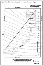
- For any sites not covered by (1)
and (2) above, there are no limits on impervious surface.
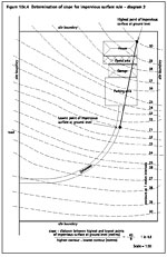
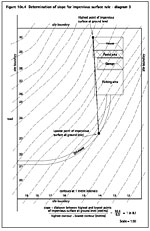
- Methodology: the slope in (1) and
(2) above will be measured beneath a horizontal straight line from the
highest point at ground level at which an impervious surface occurs
on the site, to the lowest point on the site on which impervious surfaces
occur, as illustrated in figure 10c.4: Determination of slope for impervious
surface rule.
 Image
not to scale.
Click here for printable version of Figure 10c.4.1 to correct scale
Image
not to scale.
Click here for printable version of Figure 10c.4.1 to correct scale
 Image
not to scale.
Click here for printable version of Figure 10c.4.2 to correct scale
Image
not to scale.
Click here for printable version of Figure 10c.4.2 to correct scale
 Image
not to scale. Click here for printable
version of Figure 10c.4.3 to correct scale
Image
not to scale. Click here for printable
version of Figure 10c.4.3 to correct scale
10c.4.9.2 Restricted
discretionary activities
An infringement of the impervious surface area controls
is a restricted discretionary activity.
Matters of discretion
The council has restricted its discretion to considering
the following matters:
- The extent to which the site can store,
reuse or absorb all of the stormwater discharges from impervious surfaces
on the site.
- The potential for erosion, siltation
and flooding of land and water bodies from stormwater discharges from
impervious surfaces on the site.
- Whether a low impact design approach
has been used.
The Auckland Regional Council's Technical Publication
124 Low Impact Design Manual for the Auckland Region (2000) will be
of assistance to applicants as it outlines stormwater management techniques
that protect and incorporate natural site features into erosion and
sediment control.
- Any stormwater treatment.
- The extent to which wastewater disposal
areas are protected from stormwater discharged from impervious surfaces.
- The slope of impervious surfaces.
- The availability of land for the
suitable disposal of wastewater and stormwater on the site.
- The necessity for the impermeable
surfaces.
Notification requirements
The notification requirements are set out in clause
10c.3.2.
10c.4.9.3 Explanation
for impervious surface controls
Stormwater is not reticulated in the islands and therefore
must be disposed of on site. With the exception of parts of Oneroa village,
wastewater must also be disposed of on site. Sufficient permeable surfaces
must be available for every site to dispose of the both the stormwater
generated from impervious surfaces on the site, as well as the wastewater.
The degree of vegetation cover and the slope of the land as well as
soil type moderate absorption of stormwater. Soils on some of the islands
such as Waiheke are typically derived from Waitemata sandstones and
clay and in the absence of natural vegetation are easily waterlogged.
Therefore it is necessary to control the amount of impervious surfaces
on small sites to minimise the adverse effects stormwater may have when
concentrated by impervious surfaces, including flooding, siltation,
erosion and pollution of adjacent properties and streams.
10c.5 Controls
for conservation and amenity
10c.5.1 Indigenous
vegetation protection
The following rule applies to all indigenous vegetation
within the islands, with the exception of indigenous vegetation located
within the legal road.
Note: Refer also to clause 8.5.1 for additional vegetation
rules related to natural hazards and to part 7 - Heritage for the rules
applying to scheduled trees.
10c.5.1.1 Permitted
activities
The following are permitted activities:
- The pruning or removal of indigenous
vegetation less than 3m in height, where the cumulative amount of indigenous
vegetation removal, which is less than 3m in height, does not exceed
that specified in tables 10c.1 to 10c.6: Development controls for the
relevant land unit or settlement area.
- The excavation, deposition of material,
construction, work, emplacement of services, storage or other activity
in, on, above or under, the dripline (branch spread) of indigenous vegetation
less than 3m in height.
- The maintenance or trimming of any
indigenous vegetation greater than 3m in height with hand operated secateurs.
- On Great Barrier only, the pruning,
removal or works within the dripline of kanuka up to 6m in height.
- The removal of vegetation or part
of any indigenous vegetation greater than 3m in height that is dead
or that is suffering from an untreatable disease which has caused, and
will continue to cause, significant decline in its health.
10c.5.1.2 Restricted
discretionary activities
The following are restricted discretionary activities:
- The pruning or removal of indigenous
vegetation greater than 3m in height (other than as provided for under
(4) below).
- The excavation, deposition of material,
construction, work, emplacement of services, storage or other activity,
in, on, above or under, the dripline (branch spread) of any indigenous
vegetation greater than 3m in height (other than as provided for under
(4) below).
- The removal of a cumulative amount
of indigenous vegetation, which is less than 3m in height, for any site
which exceeds that specified in tables 10c.1 to
10c.6: Development controls
for the relevant land unit or settlement area.
- On Great Barrier only, the pruning,
removal or works within the dripline of kanuka greater than 6m in height.
- The destruction, removal or modification
of the habitat of any rare, threatened or endemic species listed in
appendix 6 - List of threatened and unusual plant and animal species.
Matters of discretion
The council has restricted its discretion to considering
the following matters:
- the applicants' need to obtain a practicable
building site, access, parking area, or to install services to the land
- the quantity, quality and extent of the
vegetation
- visual and amenity effects
- effects on the habitats of indigenous
fauna
- the presence of species that are rare,
threatened or endemic to the islands (refer appendix 6 - List of threatened
and unusual plant and animal species)
- effects on slope instability and erosion
- mitigation planting
- the consideration of alternatives.
Notification requirements
The notification requirements are set out in clause
10c.3.2.
10c.5.1.3 Explanation
for indigenous vegetation protection
The council has limited the removal of indigenous vegetation
in order to protect the natural character and the landscape, ecological
and amenity values of the islands. It includes limitations on both the
cumulative (m2) extent of indigenous vegetation which may
be cleared, below 3m in height, and on works within the dripline, modification
and removal of indigenous vegetation above 3m in height.
The height restrictions are set in recognition of the
relative maturity of trees and shrubs above those limits and the important
contribution they make to the natural character and the landscape, ecological
and amenity values of the islands. In some land units and settlement
areas, indigenous vegetation below 3m in height, may only be cleared
if a resource consent is obtained. This control recognises that vegetation
is a key element which must be retained to protect the specific values
of the land units and settlement areas.
10c.5.2 Exotic
tree protection
The following rules apply to exotic trees on Waiheke,
which are not located within the legal road. There are no exotic tree
protection controls on any of the other islands. Waiheke is the only
island where they apply.
Note: Refer also to clause 8.5.1 for additional vegetation
rules related to natural hazards and to part 7 - Heritage for the rules
applying to scheduled trees.
10c.5.2.1 Permitted
activities
The following are permitted activities:
- The pruning or removal of exotic tree(s)
less than 8m in height or with a girth (measured at 1.4m above ground)
less than 800mm.
- The excavation, deposition of material,
construction, work, emplacement of services, storage or other activity,
in, on, above or under, the dripline (branch spread) of any exotic tree(s)
less than 8m in height or with a girth (measured at 1.4m above ground)
less than 800mm.
- Any maintenance or trimming of any
exotic tree over 8m in height or with a girth (measured at 1.4m above
ground) greater than 800mm with hand operated secateurs.
- The removal of any exotic tree over
8m in height or with a girth (measured at 1.4m above ground) greater
than 800mm that is dead or that is suffering from an untreatable disease
which has caused, and will continue to cause, significant decline in
its health.
Exception
The pruning, removal or works within the dripline of
any of the following species is a permitted activity:
- all Pinus species
- all Acacia (wattle) species
- trees being used as shelter belts in landform
1-7 and rural 1-3.
- fruit trees
- any plant pest species listed in appendix
14 - List of plant pest species.
Note: For the avoidance of doubt it is noted that Araucaria
heterophylla (Norfolk Island pine) and Cupressus macrocarpa (macrocarpa)
are subject to the exotic tree protection controls.
10c.5.2.2 Restricted
discretionary activities
The following are restricted discretionary activities:
- The pruning or removal of exotic tree(s)
over 8m in height or with a girth (measured at 1.4m above ground) greater
than 800mm.
- The excavation, deposition of material,
construction, work, emplacement of services, storage or other activity,
in, on, above or under, the dripline (branch spread) of any exotic tree(s)
over 8m in height or with a girth (measured at 1.4m above ground) greater
than 800mm.
Matters of discretion
The council has restricted its discretion to considering
the following matters:
- the applicants' need to obtain a practicable
building site, access, a parking area, or to install services to the
land
- visual and amenity effects
- effects on the habitats of indigenous
fauna
- effects on slope instability and erosion
issues
- mitigation planting
- the consideration of alternatives.
Notification requirements
The notification requirements are set out in clause
10c.3.2.
10c.5.2.3 Explanation
for exotic tree protection controls
The council has imposed limits on the removal of exotic
trees over a particular height or girth principally in recognition of
the contribution these larger exotic trees make to visual amenity values
on Waiheke. It is also recognised that some exotic species can provide
valuable food sources for native fauna, and are important for water
and soil conservation.
10c.5.3 Exotic
tree and indigenous vegetation protection on legal roads
The exotic tree protection controls on legal roads apply
to Waiheke only.
Note: Refer to also to part 5 - Network utility services
for tree modification or removal in relation to network utility services,
part 7 - Heritage for rules applying to scheduled trees and to
clause
8.5.1 for additional vegetation controls related to natural hazards.
10c.5.3.1 Permitted
activities
The following are permitted activities:
- The pruning or removal of indigenous
vegetation less than 3m in height.
- The excavation, deposition of material,
construction, work, emplacement of services, storage or other activity,
in, on, above or under, the dripline (branch spread) of any indigenous
vegetation less than 3m in height.
- The maintenance or trimming of any
indigenous vegetation greater than 3m in height with hand operated secateurs.
- The pruning of indigenous vegetation
greater than 3m in height where no more than 30 per cent of the foliage
is removed in any one calendar year.
- On Great Barrier only, the pruning,
removal or works within the dripline of kanuka up to 6m in height.
- The removal of vegetation or part
of any indigenous vegetation greater than 3m in height that is dead
or that is suffering from an untreatable disease which has caused, and
will continue to cause, significant decline in its health.
- The pruning or removal of exotic
tree(s) less than 8m in height or with a girth (measured at 1.4m above
ground) less than 800mm.
- The excavation, deposition of material,
construction, work, emplacement of services, storage or other activity,
in, on, above or under, the dripline (branch spread) of any exotic tree(s)
less than 8m in height or with a girth (measured at 1.4m above ground)
less than 800mm.
- Any maintenance or trimming of any
exotic tree over 8m in height or with a girth (measured at 1.4m above
ground) greater than 800mm with hand operated secateurs
- The pruning of any exotic tree(s)
greater than 8m in height or with a girth (measured at 1.4m above ground)
greater than 800mm where no more than 30 per cent of the foliage is
removed in any one calendar year.
- The removal of any exotic tree
over 8m in height or with a girth (measured at 1.4m above ground) greater
than 800mm that is dead or that is suffering from an untreatable disease
which has caused, and will continue to cause, significant decline in
its health.
Note: Items 7-11 apply to Waiheke only.
Exception
The pruning, removal or works within the dripline of
any of the following species within the legal road is a permitted activity:
- all Pinus species
- all Acacia (wattle) species
- trees being used as shelter belts
- fruit trees
- any plant pest species listed in appendix
14 - List of plant pest species.
Note: For the avoidance of doubt it is noted that Araucaria
heterophylla (Norfolk Island pines) and Cupressus macrocarpa (macrocarpa)
are subject to the exotic tree protection controls for roads.
10c.5.3.2 Restricted
discretionary activities
The following are restricted discretionary activities:
- The removal of indigenous vegetation
greater than 3m in height (other than as provided for under (4) below).
- The excavation, deposition of material,
construction, work, emplacement of services, storage or other activity
in, on, above or under, the dripline (branch spread) of any indigenous
vegetation greater than 3m in height (other than as provided for under
(4) below).
- The pruning of indigenous vegetation
greater than 3m in height where more than 30 per cent of the foliage
is removed in any one calendar year.
- On Great Barrier only, the pruning,
removal or works within the dripline of kanuka greater than 6m in height.
- The destruction, removal or modification
of the habitat of any rare, threatened or endemic species listed in
appendix 6 - List of threatened and unusual plant and animal species.
- The removal of exotic tree(s) over
8m in height or with a girth (measured at 1.4m above ground) greater
than 800mm.
- The excavation, deposition of material,
construction, work, emplacement of services, storage or other activity
in, on, above or under, the dripline (branch spread) of any exotic tree(s)
over 8m in height or with a girth (measured at 1.4m above ground) greater
than 800mm.
- The pruning of any exotic tree(s)
greater than 8m in height or with a girth (measured at 1.4m above ground)
greater than 800mm where more than 30 per cent of the foliage is removed
in any one calendar year.
Note: Items 6-8 apply to Waiheke only.
Matters of discretion
The council has restricted its discretion to considering
the following matters:
- the need to operate, maintain and upgrade
the road
- the applicants' need to obtain access,
a parking area, or to install services to the land
- visual and amenity effects
- the habitats of indigenous fauna
- effects on slope instability and erosion
issues
- mitigation planting
- the consideration of alternatives.
Notification requirements
The notification requirements are set out in clause
10c.3.2.
10c.5.3.3 Explanation
for vegetation protection controls on legal roads
The Plan has imposed limits on the modification and
removal of trees located on roads in recognition of their contribution
to visual, ecological and amenity values in the islands. However, some
exclusion is provided for the pruning of trees and vegetation located
within the legal road so that management of these assets can be adequately
provided for.
10c.5.4 Noise
- With the exception of (2), (3), and (4)
below, or where specific noise controls apply within a land unit or
settlement area, the following noise standards apply to all activities.
- Unless otherwise stated the Leq
noise level must not exceed the limits specified in tables 10c.1 to
10c.6: Development controls for the relevant land unit or settlement
area.
- The maximum noise level (Lmax)
at 'night' time must not exceed 75dBA.
Note: these noise levels apply on adjacent sites
where residential activities occur.
- All activities in commercial 5 which
are adjacent to sites which are not used for residential purposes must
meet a Leq noise level of 70dBA. This must be measured at
the boundary of the site. The noise standards in table 10c.1 will apply
on adjacent sites where residential activities occur.
Note: Apart from the boundary noise standard above,
no additional noise controls apply to dwellings located within commercial
5.
- The Leq noise level arising
from the use of any generator (except a wind powered generator) used
solely for the generation of electricity must not exceed the following
limits:
|
Monday
to Sunday 7.00am to 10.00pm: |
55dBA |
|
At all other times: |
45dBA |
- The sound level from any wind turbine
generator must not exceed the background sound level (L95) by more than
5dBA, or a level of 40dBA L95, whichever is the greater at wind speeds
up to 15m/s.
Methodology: The sound level must be measured
in accordance with section 4.5 and 5.2 of NZS 6808:1998 Acoustics -
The Assessment and Measurement of Sound from Wind Turbine Generators
except that measurements above 15m/s will not be necessary. When the
sound of a wind turbine generator has special audible characteristics
a maximum penalty of +5dBA will be applied to the measured sound level.
Notes:
- For rules (1), (2) and (3) above refer
to clause 4.7 which sets out the methodology for measuring noise.
- For noise controls applying to helipads
and airstrips in landform 1-7 on Great Barrier, refer to
clause 13.8.2.
Explanation
The purpose of imposing noise controls is to ensure
that noise does not adversely affect amenity values and because excessive
noise can be detrimental to public health. Quantitative noise limits
have been prescribed in the Plan to maintain existing background noise
levels and to maintain amenity. These general limits have been varied
in a number of land units in recognition of the type of activity occurring
and where a different level of environmental amenity is acceptable.
10c.5.5 Noise
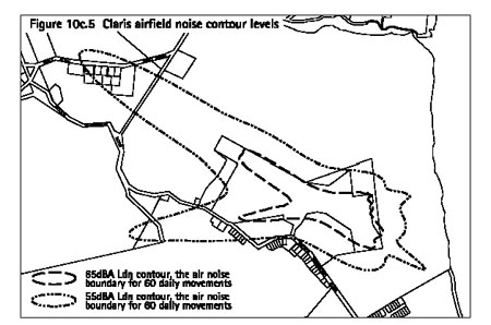
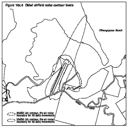
management at Claris and Okiwi airfields
If the following activities are listed as permitted
in the applicable land unit or settlement area, but are proposed to
be located between the Ldn (day / night level) 55 and 65dBA noise contours
around Claris and Okiwi airfields (see note below), then they are restricted
discretionary activities:
- the construction or relocation of dwellings
- alterations and additions to the exterior
of existing dwellings
- educational facilities
- community facilities
- heathcare services.
Note: The locations of the Ldn 55 and 65dBA noise contours
around Claris and Okiwi airfields are identified on the planning maps.
These contours are also shown on figure 10c.5: Claris airfield noise
contour levels and figure 10c.6: Okiwi airfield noise contour levels.
Matters of discretion
When considering an application for the activities listed
above, the council has restricted its discretion to considering the
following the matter:
- The extent to which the building can be
designed or modified to reduce the noise from aircraft movements to
a reasonable level, while meeting the ventilation requirements of the
building code.
Notification requirements
The notification requirements are set out in clause
10c.3.2.
Explanation
The purpose of the rule is to manage the location of
sensitive activities in areas of high cumulative noise around Claris
and Okiwi airfields. Where noise sensitive activities are proposed to
locate between the Ldn 55 and 65dbA noise contours, the council will
require consent to assess to how the building can be designed and modified
so that adverse effects from aircraft noise can be remedied or mitigated.
This is to ensure that reverse sensitivity matters are addressed so
that the operation of the airfields is not put at risk.
10c.5.6 Earthworks
In addition to the rules set out below, more restrictive
earthworks controls may also apply under other provisions of the Plan.
Particular regard should be had to the following:
The definition of earthworks in part 14 - Definitions
does not include quarrying. Quarrying is provided for in commercial
6 and in the quarry area of the Medlands settlement area.
Methodology: For the purposes of the rules below, slope
means the slope of the land surface measured by the nearest route from
the bottom to the top of the area of land to be disturbed. It should
have an accuracy no less than that achieved by a hand held inclinometer
or abney level.
10c.5.6.1 Permitted
activities
The following are permitted activities:
- Subject to compliance with the standards
set out in clause 10c.5.6.2 below, earthworks where:
- the land subject to earthworks has a
slope of greater than 1 in 6; and
- the contiguous extent of the earthworks
measured in square metres does not exceed the limit specified in
tables 10c.1 to 10c.6: Development controls for the relevant land unit or settlement
area.
- Subject to compliance with the standards
set out in clause 10c.5.6.2 below, earthworks where:
- the land subject to earthworks has a
slope of less than or equal to 1 in 6; and
- the contiguous extent of the earthworks
measured in square metres does not exceed the limit specified in table
10c.1 for the relevant land unit or settlement area.
- With the exception of landform 1,
2 and 4, earthworks to dig trenches for network utility services or
effluent disposal systems where all of the following are met:
- The utility services include water, power,
wastewater, drainage, telecommunications, or other in ground services
of a similar character.
- No more earth is removed than is
absolutely necessary for the trench.
- The trench does not remain open
for more than 48 hours.
- The reinstated disturbed land is
revegetated or otherwise protected from soil erosion as soon as practicable
after completion of the works.
- The earthworks comply in all respects
with the standards set out in clause 10c.5.6.2 below.
- Earthworks to construct farm tracks
in landform 3 and 5 on Great Barrier where:
- The tracks are required for farming activities;
and
- The earthworks comply in all respects
with the standards set out in clause 10c.5.6.2 below.
- Earthworks to construct new farm
drains in landform 3 and 5 on Great Barrier.
- Earthworks associated with the cleaning
and maintenance of existing farm drains.
- Earthworks for the use, maintenance
and upgrading of existing formed public roads as provided for in part 5 - Network utility services.
- Gardening for domestic purposes.
- Cultivation associated with agriculture
or horticulture.
- The digging of holes for the erection
of posts or poles.
10c.5.6.2 Standards
for permitted activities
The permitted activities must comply in all respects
with the following standards:
- All earthworks are undertaken using erosion
and sediment control measures to ensure that, in so far as is practicable,
soil erosion is minimised and sediment does not enter into wetland or
water bodies. For information on how to achieve this refer appendix
16 - Erosion and sediment control guidelines for earthworks.
- No material must be deposited on
any public road. Means to avoid depositing material on the road are
set out in appendix 16.
- Any surplus excavated material which
is not reused on site, must be disposed of in a legally authorised manner.
- Where evidence of a burial site
or any other archaeological site is found or exposed on an area where
earthworks is occurring, all work must cease immediately and the council
and the Historic Places Trust must be advised immediately.
Note: On receipt of such advice it is the council's
practice to consult with the relevant authorities (Historic Places Trust,
Department of Conservation, tangata whenua) and the owner of the property
with regard to the appropriate treatment of the site.
10c.5.6.3 Restricted
discretionary activities
The following are restricted discretionary activities:
- Earthworks where:
- the land subject to earthworks has a
slope of greater than 1 in 6; and
- the contiguous extent of the earthworks
measured in square metres exceeds the limit specified in tables 10c.1 to
10c.6: Development controls for the relevant land unit or settlement
area.
- Earthworks where:
- the land subject to earthworks has a
slope of less than or equal to 1 in 6; and
- the contiguous extent of the earthworks
measured in square metres exceeds the limit specified in
tables 10c.1 to 10c.6 for the relevant land unit or settlement area.
Matters of discretion
The council has restricted its discretion to considering
the following matters:
- adverse effects from soil erosion and
generation of sediments
- adverse effects on visual or other landscape
qualities
- adverse effects on adjacent sites and
public roads
- adverse effects on significant environmental
features, water systems, scheduled heritage items, or sites of cultural
significance.
Assessment criteria
The council's assessment of an application for earthworks
under this clause will consider the matters set out in clause 10c.5.6.5.
Notification requirements
The notification requirements are set out in clause
10c.3.2.
10c.5.6.4 Discretionary
activities
The following is a discretionary activity:
- Earthworks where more than 5000m3
of cleanfill is transported by public road to or from the area subject
to earthworks. The 5000m3 is expressed as a solid measure.
The council's assessment of an application for earthworks
under this clause will include consideration of the matters set out
in clause 10c.5.6.5.
10c.5.6.5 Assessment
criteria
The following assessment criteria apply to applications
under clauses 10c.5.6.3 and 10c.5.6.4.
- The extent to which the earthworks can
be undertaken in a manner which minimises adverse effects arising from
soil erosion and the generation of sediments, taking into account:
- the steepness of the land (slope angle
and horizontal length)
- soil type and stability
- existing vegetation cover
- proximity to wetland and water systems
- proposed sediment and erosion control
measures
- the time of year and the length of time
soil is likely to be exposed
- proposed disposal of surplus soil or
requirements for importing cleanfill
- proposed reinstatement and stabilisation
including planting and drainage.
- The extent to which the earthworks
are likely to have adverse effects on visual or other landscape qualities
which cannot be avoided, remedied or mitigated having regard to:
- proposed planting or other landscaping
- effects on the natural character of the
coastal environment
- visibility from public places such as
roads and reserves, and from coastal waters
- the extent and depth of cut and fill.
- The extent to which measures can
be taken to avoid, remedy or mitigate adverse effects on adjacent sites
and on public roads taking into account:
- the hours of operation and duration of
the earthworks activities
- provision for the maintenance of public
roads giving access to the site
- road safety
- dust mitigation measures.
- The extent to which protection and
management measures can be undertaken to avoid, remedy or mitigate adverse
effects on significant environmental features, water systems, scheduled
heritage items, or sites of cultural significance.
10c.5.6.6 Bylaw
and regional requirements
All works in flood plains and overland flow paths must
comply with the relevant part of the council's bylaw which controls
stormwater management.
Earthworks over 0.25ha in area; roading, tracking or
trenching over 100m in length; works within floodplains or watercourses
(including diversion); and cultivation of soil for commercial crop production
may require resource consent from the Auckland Regional Council prior
to the activity commencing. The ARC should be contacted to determine
whether a consent is required and to discuss technical requirements.
10c.5.6.7 Explanation for earthworks controls
A major reason for controlling earthworks is to minimise
the potential for erosion and sedimentation which can have adverse effects
on water bodies, wetlands and coastal systems. Permitted activity standards
require the implementation of erosion and sediment control measures
for all earthworks activities to avoid the adverse effects from sediment
runoff. The steepness of the land and the extent of the earthwork are
the main factors which determine how much sediment leaves an area of
earthworks. The earthworks controls therefore include limits based on
slope and exposed surface area. Above the specified limits a resource
consent is required.
A limit is also placed on the volume of cleanfill which
can be transported by public road either to or from the site as a restricted
discretionary activity. Larger proposals, involving more than 5000m3
of cleanfill being transported by public road, are discretionary activities.
Earthworks are not permitted as of right in landform
1, 2 and 4. This is in keeping with the objectives of these land units
which emphasise the need to protect their natural character.
Earthworks can have an adverse visual impact due to
the removal of vegetation and the alteration of landforms. Visual effects
are most obvious during the construction phase but reduce over time
if planting and other landscaping is established round the new building
or driveway. Adverse visual effects are more likely to occur where earthworks
occur on steeper landforms with a coastal location.
The requirement to cease earthworks if a burial site
or any other archaeological features are exposed is included in recognition
of the obligations under the Historic Places Act.
10c.5.7 Coastal,
wetland and water body protection yards
- No building must be located in, on or
over the coastal, wetland or water body protection yards specified in
tables 10c.1 to 10c.6: Development controls for the relevant land unit
or settlement area.
- No earthworks must be undertaken
within the coastal, wetland or water body protection yards specified
in tables 10c.1 to 10c.6: Development controls for the relevant land
unit or settlement area.
- Methodology: yards must be measured
on the horizontal plane from either the line of mean high water springs,
or the edge of any wetland or water body.
- The requirements of these yards
will replace any other yard requirement.
Explanation
Coastal, wetland and water body protection yards are
imposed to help preserve the natural character of the coastal environment
and the margins of wetlands and water bodies, to maintain and enhance
water quality, and to preserve amenity values.
10c.5.8 Building
restriction yard
There must be no buildings constructed within the area
contained between any building restriction yard shown on the planning
maps and a site boundary, or the line of mean high water springs.
Explanation
Controls on the construction of buildings are imposed
where it is necessary to control amenity values in an area. In some
cases it is necessary to ensure the visual quality of an area is maintained.
Limits on buildings so that they cannot be located in places where the
above outcomes are sought, are therefore necessary. The building restriction
yards shown on the planning maps define these areas.
10c.5.9 Relationship
with rules in other parts of the Plan
Part 14 - Definitions must be referred to as it is likely
to contain definitions of terms in this part of the Plan.
The following parts of the Plan should also be referred
to as they may contain rules which apply to a particular site or proposal:
- Part 4 - General rules
- Part 5 - Network utility services
- Part 6 - Financial contributions
- Part 7 - Heritage
- Part 8 - Natural hazards
- Part 9 - Hazardous facilities and contaminated land
- Part 10a - Land units: objectives, policies and activity
tables
- Part 10b - Settlement areas: objectives, policies and
activity tables
- Part 12 - Subdivision
- Part 13 - Connectivity and linkages
Table 10c.1: Development controls - landforms
1-7, island residential 1 and 2
| Land
units |
Landform
1 (coastal cliffs and slopes) |
Landform
2 (dune systems and sand flats) |
Landform
3 (alluvial flats)
|
Landform
4 (wetland systems)
|
Landform
5 (productive land) |
Landform
6 (regenerating slopes)
|
Landform
7 (forest and bush) |
Island
residential 1 (traditional residential) |
Island
residential 2 (bush residential) |
| Dune
systems |
Sand
flats |
| Bulk and
location of buildings: |
| Height |
n/a |
n/a |
8m |
8m |
n/a |
8m |
8m |
8m |
8m |
8m |
| Front yards
|
n/a |
n/a |
6m |
6m |
n/a |
6m |
6m |
6m |
4m |
4m |
| Side and rear yards |
n/a |
n/a |
1.5m |
1.5m |
n/a |
1.5m |
1.5m |
1.5m |
1.5m |
1.5m |
| Building coverage |
n/a |
n/a |
20% of net site area or 250m2
whichever is the lesser |
20% of net site area or 250m2
whichever is the lesser |
n/a |
1000m2 (max. footprint
of any one building is 300m2) |
500m2
|
10% of net site area or 250m2
whichever is the lesser |
15% of net site area
|
15% of net site area |
| Conservation
and amenity: |
| Indigenous vegetation
removal (below 3m in height) |
NC
|
NC
|
250m2
|
500m2
|
NC
|
unlimited
|
1000m2 |
250m2 |
300m2 |
300m2 |
| Noise (Leq
levels): Monday to Saturday 7am to 10pm and Sunday
9am to 6pm
All other times including public holidays
(night time)
|
45dBA
35dBA
|
45dBA
35dBA
|
45dBA
40dBA
|
50dBA
40dBA
|
45dBA
35dBA
|
50dBA
40dBA
|
45dBA
40dBA
|
45dBA
40dBA
|
50dBA
40dBA
|
50dBA
40dBA
|
| Earthworks on land with
a slope >1 in 6 |
NC |
NC |
50m2 |
50m2 |
NC |
50m2 |
50m2 |
50m2 |
50m2 |
50m2 |
| Earthworks on land with
a slope <1 in 6 |
NC |
NC |
50m2 |
400m2 |
NC |
400m2 |
400m2 |
200m2 |
400m2 |
400m2 |
| Protection
yards:
- coastal (MHWS)
- wetland and water bodies
|
n/a
n/a
|
n/a
n/a
|
40m
20m
|
40m
20m
|
n/a
n/a
|
40m
20m
|
40m
20m
|
40m
20m
|
30m
20m
|
30m
20m
|
Key:
NC - Denotes a non-complying activity.
n/a - Denotes where buildings or activities are not
provided for, or where the particular circumstances of the land unit
mean that the development control does not apply. Therefore no development
control has been attributed.
Note: This is a summary table and must be used in conjunction
with the more detailed rules elsewhere in part 10c. There are also some
development controls which are not displayed in this table ie building
in relation to boundary, ridgeline control, impervious surface area,
exotic tree protection (Waiheke only), and building restriction yards.
Table 10c.2: Development controls - commercial
1-7
| Land
units |
Commercial
1 (Oneroa village)
|
Commercial
2 (Ostend village) |
Commercial
3 (local shops) |
Commercial
4 (visitor facilities)
|
Commercial
5 (industrial) |
Commercial
6 (quarry) |
Commercial
7 (wharf)
|
| Bulk and
location of buildings: |
| Height |
Refer land unit rules |
8m |
8m |
8m
|
8m |
8m |
6m |
| Front yards
|
0m (Also refer to land unit rules |
Refer to land unit rules |
0m (Also refer to land unit rules |
4m |
Refer to land unit rules
|
Refer to land unit rules |
0m |
| Side and rear yards |
0m or 1.5m (where abutting another
land unit) |
0m or 1.5m (where abutting another
land unit) |
0m or 1.5m (where abutting another
land unit) |
1.5m |
Refer to land unit rules
|
Refer to land unit rules
|
0m |
| Building coverage |
40% of net site area ## |
40% of net site area
|
40% of net site area |
15% of net site area |
40% of net site area
|
15% of net site area |
200m2
|
| Conservation
and amenity: |
| Indigenous vegetation
removal (below 3m in height) |
300m2 |
300m2 |
300m2 |
300m2 |
300m2 |
n/a |
n/a |
| Noise (Leq
levels): Monday to Saturday 7am to 10pm and Sunday
9am to 6pm
All other times including public holidays
(night time)
|
55dBA
45dBA
|
55dBA
45dBA
|
55dBA
45dBA
|
55dBA
45dBA
|
55dBA
45dBA
|
Refer to land unit rules
|
55dBA
45dBA
|
| Earthworks on land with
a slope >1 in 6 |
50m2 |
50m2 |
50m2 |
50m2 |
50m2 |
n/a |
50m2 |
| Earthworks on land with
a slope <1 in 6 |
400m2 |
400m2 |
400m2 |
400m2 |
400m2 |
n/a |
400m2 |
| Protection
yards: - coastal (MHWS)
- wetland and water bodies
|
30m
20m
|
30m
20m
|
30m
20m
|
30m
20m
|
30m
20m
|
30m
20m
|
n/a
n/a
|
Key:
NC - Denotes a non-complying activity.
n/a - Denotes where buildings or activities are not
provided for, or where the particular circumstances of the land unit
mean that the development control does not apply. Therefore no development
control has been attributed.
'Refer to land unit rules' means see the specific rules
for the particular land unit as contained in part 10a - Land units:
objectives, policies and activity tables.
## Building coverage and / or impervious surface area
for commercial 1 is 75% of net site area if the site is connected to
the Owhanake wastewater treatment plant. (Refer to impervious surface
area rules)
Note: This is a summary table and must be used in conjunction
with the more detailed rules elsewhere in part 10c. There are also some
development controls which are not displayed in this table ie building
in relation to boundary, ridgeline control, impervious surface area,
exotic tree protection (Waiheke only), and building restriction yards.
Table 10c.3: Development controls - Matiatia
(mixed use)
| Land
unit |
Matiatia |
| Transport
area |
Mixed
use area |
Wetland
area |
| Bulk and
location of buildings: |
| Height |
6m (area A), 8m (area B) |
Refer to land unit rules |
4m |
| Front yards
|
n/a |
n/a |
n/a |
| Side and rear yards |
n/a |
n/a |
n/a |
| Building coverage |
200m2 (area A),
500m2 (area B) |
30% |
5% |
| Conservation
and amenity: |
| Indigenous vegetation
removal (below 3m in height) |
1000m2
|
300m2
|
NC |
| Noise (Leq
levels): Monday to Saturday 7am to 10pm and Sunday
9am to 6pm
All other times including public holidays
(night time)
|
55dBA
45dBA
|
55dBA
45dBA
|
50dBA
40dBA
|
| Earthworks on land with
a slope >1 in 6 |
50m2
|
50m2
|
NC
|
| Earthworks on land with
a slope <1 in 6 |
400m2 |
400m2
|
NC
|
| Protection
yards: - coastal (MHWS)
- wetland and water bodies
|
n/a
20m
|
30m
10m
|
n/a
n/a
|
Table 10c.4: Development controls - recreation
1-3, rural 1-3, and conservation
| Land
units |
Recreation
1 (local parks and esplanade reserves) |
Recreation
2 (community facilities) |
Recreation
3 (Rangihoua Park)
|
Rural
1 (rural amenity)
|
Rural
2 (western landscape)
|
Rural
3 (Rakino amenity) |
Conservation
|
| Bulk and location of buildings: |
| Height |
8m |
8m |
8m |
8m |
8m |
8m |
6.5m |
| Front yards |
1.5m |
1.5m |
4m |
6m |
6m |
6m |
6m |
| Side and rear yards |
1.5m |
1.5m |
1.5m |
1.5m |
1.5m |
1.5m |
1.5m |
| Building coverage |
10% of net site area or 250m2 whichever is lesser |
300m2 |
2500m2 (max. footprint of any one building is 250m2) |
500m2 (max. footprint of any one building is 250m2) |
500m2 (max. footprint of any one building is 250m2) |
500m2 (max. footprint of any one building is 250m2) |
10% of net site area; or for Motutapu only 1.5ha |
| Conservation and amenity |
| Indigenous vegetation removal (below 3m in height) |
300m2 |
300m2 |
Refer to land unit rules |
300m2 |
300m2 |
300m2 |
200m2 Refer also to land unit rules |
| Noise (Leq levels): Monday to Saturday
7am to 10pm and Sunday 9am to 6pm All other times including public holidays
(night time) |
45dBA
40dBA |
55dBA
45dBA |
55dBA
45dBA |
0dBA
40dBA |
50dBA
40dBA |
50dBA
40dBA |
45dBA
40dBA |
| Earthworks on land with a slope > 1 in 6 |
50m2 |
50m2 |
50m2 |
50m2 |
50m2 |
50m2 |
50m2 |
| Earthworks on land with a slope < 1 in 6 |
400m2 |
400m2 |
400m2 |
400m2 |
400m2 |
400m2 |
400m2 |
| Protection
yards: - coastal (MHWS)
- wetland and water bodies
|
30m
20m
|
40m
20m
|
40m
20m
|
40m
20m
|
40m
20m
|
40m
20m
|
40m
20m
|
Key:
NC - Denotes a non-complying activity.
n/a - Denotes where buildings or activities are not
provided for, or where the particular circumstances of the land unit
mean that the development control does not apply. Therefore no development
control has been attributed.
'Refer to land unit rules' means see the specific rules
for the particular land unit as contained in part 10a - Land units:
objectives, policies and activity tables.
Note: This is a summary table and must be used in conjunction
with the more detailed rules elsewhere in part 10c. There are also some
development controls which are not displayed in this table ie building
in relation to boundary, ridgeline control, impervious surface area,
exotic tree protection (Waiheke only), and building restriction yards.
Table 10c.5: Development controls - Pakatoa and
Rotoroa
| Land
units |
Pakatoa |
Rotoroa |
| Tourist
complex area |
Residential
area |
Landscape
protection area |
Conservation
/ residential area |
Visitor
accommodation area |
| Bulk and
location of buildings: |
| Height |
8m |
8m |
n/a |
6m |
5m in visitor area A. 8m in visitor
area B, and a max. of two storeys |
| Front yards
|
n/a |
n/a |
n/a |
n/a |
n/a |
| Side and rear yards |
1.5m |
1.5m |
n/a |
n/a |
n/a |
| Building coverage |
30% |
10% |
n/a |
300m2 per dwelling
and associated residential accessory buildings 250m2 for
the visitor information centre |
3000m2 |
| Conservation
and amenity: |
| Indigenous vegetation
removal (below 3m in height) |
1000m2
|
200m2
|
NC |
300m2 |
300m2 |
| Noise (Leq
levels): Monday to Saturday 7am to 10pm and Sunday
9am to 6pm
All other times including public holidays
(night time)
|
50dBA
40dBA
|
50dBA
40dBA
|
50dBA
40dBA
|
50dBA
40dBA
|
50dBA
40dBA
|
| Earthworks on land with
a slope >1 in 6 |
50m2
|
50m2
|
NC
|
50m2 |
50m2 |
| Earthworks on land with
a slope <1 in 6 |
400m2 |
400m2
|
NC
|
400m2 |
400m2 |
| Protection
yards: - coastal (MHWS)
- wetland and water bodies
|
40m
20m
|
40m
20m
|
n/a
n/a
|
40m
20m
|
40m
20m
|
Key:
NC - Denotes a non-complying activity.
n/a - Denotes where buildings or activities are not
provided for, or where the particular circumstances of the land unit
mean that the development control does not apply. Therefore no development
control has been attributed.
'Refer to land unit rules' means see the specific rules
for the particular land unit as contained in part 10a - Land units:
objectives, policies and activity tables.
Note: This is a summary table and must be used in conjunction
with the more detailed rules elsewhere in part 10c. There are also some
development controls which are not displayed in this table ie building
in relation to boundary, ridgeline control, impervious surface area,
exotic tree protection (Waiheke only), and building restriction yards.
Table 10c.6: Development controls - settlement
areas
| Settlement
areas |
Residential
amenity areas |
Local
retail areas |
Headland
protection area |
Visitor
accommodation area |
Reserve,
dune, coastal margin and wetland conservation areas |
Claris
light industry area |
Claris
airport area |
Mulberry
Grove School, and Okiwi School and Domain area |
Medlands
quarry area |
| Bulk and
location of buildings: |
| Height |
8m |
6.5m |
8m |
8m |
8m |
8m |
6.5m |
8m |
8m |
| Front yards
|
4m |
0m |
4m |
4m |
4m |
8m |
0m |
4m |
4m |
| Side yards |
1.5m
|
0m |
1.5m |
1.5 |
1.5m |
3m |
0m |
4m |
4m |
| Building coverage |
15% of net site area (max. footprint
of any one building is 200m2) |
45% of net site area |
15% of net site area (max. footprint
of any one building is 200m2) |
30% of net site area |
10% of net site area (max. footprint
of any one building is 200m2) |
15% of net site area |
15% of net site area |
30% of net site area |
20% of net site area |
| Conservation
and amenity: |
| Indigenous vegetation
removal (below 3m in height) |
400m2
|
1000m2 |
50m2
|
500m2 |
NC |
400m2 |
1000m2 |
200m2 |
200m2 |
| Noise (Leq
levels): Monday to Saturday 7am to 10pm and Sunday
9am to 6pm
All other times including public holidays
(night time)
|
50dBA
40dBA
|
55dBA
40dBA
|
50dBA
40dBA
|
55dBA
40dBA
|
50dBA
40dBA
|
55dBA
40dBA
|
n/a
n/a
|
55dBA
40dBA
|
Refer to settlement area rules
|
| Earthworks on land with
a slope >1 in 6 |
50m2 |
50m2
|
50m2
|
50m2
|
NC |
n/a |
n/a |
50m2 |
n/a |
| Earthworks on land with
a slope <1 in 6 |
400m2 |
400m2
|
400m2
|
400m2
|
NC |
400m2 |
400m2 |
400m2 |
n/a |
| Protection
yards: - coastal (MHWS)
- wetland and water bodies
|
40m
20m
|
40m
20m
|
40m
20m
|
40m
20m
|
40m
20m
|
n/a
40m
|
40m
40m
|
40m
20m
|
n/a
20m
|
Key:
NC - Denotes a non-complying activity.
n/a - Denotes where buildings or activities are not
provided for, or where the particular circumstances of the land unit
mean that the development control does not apply. Therefore no development
control has been attributed.
'Refer to land unit rules' means see the specific rules
for the particular land unit as contained in part 10b - Settlement areas:
objectives, policies and activity tables.
Note: This is a summary table and must be used in conjunction
with the more detailed rules elsewhere in part 10c. There are also some
development controls which are not displayed in this table ie building
in relation to boundary, ridgeline control, impervious surface area,
exotic tree protection (Waiheke only), and building restriction yards.