District Plan Hauraki Gulf Islands Section - Proposed 2006
(Notified version 2006)
Street index |
Planning maps |
Text |
Appendices |
Annexures |
Section 32 material |
Plan modifications |
Help |
Notified - Home |
Decision - Home
Part 13 - Connectivity and linkages
13.1 Introduction
13.2 Resource management issues
13.3 Resource management objectives and policies
13.4 Resource management strategy
13.5 Rules - notification requirements
13.6 Rules - site access
13.7 Rules - parking and loading
13.8 Rules - helipads and airstrips
13.1 Introduction
Connecting people, places, goods and services is an
important issue in the islands. The transport system must cater for
the movement of people and goods between the mainland and the Hauraki
Gulf, between islands in the Hauraki Gulf, and around the islands themselves.
The components of the transport system that connect people, places,
goods and services include wharves, airfields, passenger transport,
roads, cycleways, walkways and waterways. The use and development of
these resources needs to be integrated with other natural and physical
elements of the gulf islands to achieve sustainable management. This
part of the Plan seeks to facilitate a sustainable approach to transport,
and this will be the cornerstone of council's approach to addressing
transport issues throughout the islands.
13.2 Resource
management issues
Transport to, from, between and around the islands is
a vital issue for residents and visitors alike. It has had, and will
continue to have, considerable influence on the character and culture
of the islands. It is therefore important that transport issues are
robustly addressed in the Plan in a manner that is consistent with other
relevant legislation, strategies, policy documents and plans, but which
also recognises the unique influence transport issues have on the people
and communities of the islands. The following issues are identified
for the different modes of transport and associated natural and physical
resources.
13.2.1 Water
The waters of the Hauraki Gulf provide strategic linkages
between the islands and from the mainland. They form an integral part
of the overall transport network of the islands. A number of different
types of water transport occur within the Hauraki Gulf. These currently
include commuter and visitor ferry links, freight movement, charter
boats, recreational boats and cruise ships. While the council's authority
under the RMA extends only to mean high water springs, land use decisions
impact on the effectiveness and efficiency of water transport. It is
therefore important that the council works closely with the Auckland
Regional Council, other relevant authorities, passenger transport operators
and stakeholders to ensure an integrated and sustainable approach is
undertaken.
Principal issues
The significant resource management issues which need
to be addressed in the Plan are:
- How to ensure close working relationships
between the council and the relevant statutory bodies and stakeholders,
who have authority and interests in the coastal marine area, to ensure
an integrated and sustainable approach is undertaken to water transport.
- How to protect the character and
amenity of the islands while providing the necessary infrastructure
to serve the needs of water transport and freight operators and recreational
users.
13.2.2 Wharves
Wharves are a significant asset providing access for
people, goods and services to and from the islands, as well as being
used for boat launching, yachting and recreational fishing. Wharves
also often require passenger terminals and connections to other land
transport infrastructure such as carparking, bus stations, walkways,
cycleways and taxi services to operate efficiently and effectively.
While wharves within the Hauraki Gulf are controlled by other parts
of the Plan, and the Auckland Regional Plan: Coastal, the connectivity
and linkages section must be integrated with these provisions, and ensure
that access to and from the wharves operates efficiently and effectively.
Principal issue
The significant resource management issue which needs
to be addressed in the Plan is:
- How to ensure that the land transport
system that provides for access to wharves within the islands operates
effectively and efficiently.
13.2.3 Airstrips
and helipads
The council owns and operates two airstrips on Great
Barrier. The Plan acknowledges that air travel to Great Barrier is of
increasing importance and that Claris airfield in particular plays a
significant role in moving people and goods and helps enable the people
and communities of Great Barrier to provide for their social and economic
wellbeing.
There are also smaller airstrips and helipads in the
islands. Some of these airstrips and helipads provide access to remote
locations, or are used in the landform land units for farming operations.
Others provide access to sites that are more easily accessed by other
modes of transport, or for commercial operations. Air travel has different
effects to land based transport, particularly noise.
Principal issues
The significant resource management issues which need
to be addressed in the Plan are:
- How to provide for the effective and
efficient operation of airfields used for passenger transport purposes
so they can serve the wider community, both now and in the future.
- How to provide for continued private
air access to remote locations.
- How to ensure that the adverse effects
of air travel are mitigated or avoided, where necessary.
13.2.4 Roading
The road network caters for passenger transport, private
vehicles, cyclists and pedestrians. It is used for access to shopping,
employment, education, entertainment, recreation and to access the wharves
and airfields that provide for entry and exit to and from the islands.
Therefore, it is a very important physical resource. While the quality
of the road network is variable it still represents a significant physical
resource that must be sustainably managed.
The construction of new roads may give rise to adverse
effects, such as sediment runoff from earthworks, stormwater runoff
and vegetation removal. The council needs to consider how the construction
of new roads will be managed to ensure that the adverse effects are
adequately mitigated.
The Plan acknowledges that there are many unformed legal
roads, especially on Great Barrier. Many of these unformed legal roads
are unlikely to be constructed due to a variety of factors, such as
their location, geography and demand. The council must therefore consider
how these are addressed in the future.
Principal issues
The significant resource management issues which need
to be addressed in the Plan are:
- How to maintain accessibility and mobility
while appropriately managing the traffic effects.
- How to manage the construction effects
of new roads.
- How to manage the unformed legal
roads throughout the islands.
13.2.5 Parking
and access
The provision and management of parking, loading and
on-site circulation plays a significant role in the ability of people
to safely and efficiently access land use activities for work, recreation,
shopping and business. It directly impacts on the use of private motor
vehicles and cycles as a primary mode of transport for these activities.
Adverse effects can occur when the demand for parking for an activity
exceeds that provided on-site and there is an overspill of parking on
the adjacent roadside. The safe and efficient use and capacity of the
road can be adversely affected by parked or manoeuvring vehicles, while
the amenity of an area can also be adversely affected by on-street parking.
To avoid or reduce these effects, the Plan ensures that adequate on-site
parking and loading is provided for all activities. However, the council
is mindful that on-site parking can generate adverse effects such as
vegetation modification and removal, increased impervious surface areas,
reduced private open space, reduced wastewater disposal areas, increased
earthworks and sediment runoff. An oversupply of parking can also encourage
reliance on private vehicle trips when viable alternative modes of transport
are available.
Unrestricted vehicle access to properties located near
intersections, or on busy roads with an important through traffic function
can adversely affect the efficient functioning of the road network,
and give rise to safety issues. Also, many sites on the islands are
steep and well vegetated, which can make access difficult. Development
of accessways can give rise to adverse effects, such as vegetation removal,
earthworks and sediment runoff, and stormwater runoff. Given the need
for on-site wastewater disposal and the rural nature of large parts
of the islands, the site sizes are relatively large. Dwellings are often
located considerable distance from the road, either to maximise views,
access to sunlight, or achieve appropriate building platforms which
in turn means that accessways are long. It is therefore necessary for
council to control accessways to ensure appropriate access is provided,
without giving rise to adverse environmental effects.
Principal issues
The significant resource management issues which need
to be addressed in the Plan are:
- How to ensure that an appropriate level
of on-site parking is provided so that amenity, accessibility and the
efficient operation of the transport network is maintained, while not
giving rise to adverse effects.
- How to ensure that access to sites
does not cause significant adverse effects and that it is not left unrestricted
at inappropriate locations.
13.2.6 Cycling
and walking
The council recognises the important contribution that
cycling and walking can make to managing travel demand through its Cycling
and Walking Strategy 1998. However, in the islands the sealed carriageway
of many roads is not sufficiently wide for safe cycling, and cycling
facilities are only provided for in limited locations. For pedestrians,
only parts of the islands have footpaths.
Principal issues
The significant resource management issues which need
to be addressed in the Plan are:
- How to encourage a safe and efficient
pedestrian and cycle network in the islands.
- How to ensure that adequate provision
is made for bicycle facilities so that cycling is appropriately recognised
and provided for.
13.2.7 Passenger
transport
Passenger transport is the principal means of access
to the islands from the mainland. It is also an important method of
transport around the islands. Existing bus services on some islands
link with the ferry service. With car travel putting pressure on the
existing road network it is important that the Plan integrates land
use planning with transport and provides for the efficient and effective
operation of passenger transport.
Principal issue
The significant resource management issue which needs
to be addressed in the Plan is:
- How to ensure that the importance of passenger
transport is recognised in the Plan and its use encouraged throughout
the islands.
13.3 Resource
management objectives and policies
13.3.1 Objective -
wharves
To sustainably manage the use and development of the
islands' wharves and associated infrastructure, while protecting the
character and amenity values of the islands.
Policies
- By recognising and providing for wharves
and associated infrastructure at appropriate locations.
- By integrating the land transport
network with wharves to ensure accessibility to and from the islands
is maintained and enhanced.
13.3.2 Objective
- airstrips and helipads
To sustainably manage the use of the islands' airstrips
and helipads and associated infrastructure, while protecting the character
and amenity values of the islands.
Policies
- By recognising and providing for the
use and development of airstrips used for passenger and goods transport
purposes and their associated infrastructure at appropriate locations.
- By avoiding the location of activities
sensitive to aircraft noise within the Claris and Okiwi airfield noise
contours, unless the adverse effects can be adequately mitigated.
- By recognising the need for helipads
in remote locations, which may be difficult to access by other modes
of transport.
- By recognising that airstrips or
helipads may be required for farming activities in the landform and
rural land units.
- By not providing for helipads in
locations that can adversely affect the amenity of surrounding residents.
13.3.3 Objective
- roading
To recognise and provide for the existing road system
as an important resource for an integrated transport network, while
managing it to ensure the adverse effects on the surrounding environment
are minimised.
Policies
- By providing for and enhancing the road
network to ensure it is safe, effective and efficient for vehicles,
cyclists and pedestrians.
- By reducing conflicts between vehicles,
pedestrians and cyclists around key community focal points, such as
wharves, commercial centres, schools and other public facilities.
- By requiring a low impact design
approach for new roads.
- By continuing the council's programme
for legalising roads.
- By adopting and applying a functional
road classification to roads on Waiheke to control access at specified
locations.
- By discouraging traffic generating
activities in environments where they would have significant adverse
effects.
13.3.4 Objectives
- parking and access
13.3.4.1 Objective
To ensure the impact of activities on the safety and
efficiency of the road network is addressed while avoiding adverse effects
on the environment.
Policies
- By requiring sufficient on-site parking
to meet the demand generated by different activities.
- By ensuring that there is not an
oversupply of on-site parking, which can encourage traffic generation
and result in unnecessary on-site modification.
- By encouraging travel management
plans to reduce the adverse effects of travel from new development.
- By placing an upper limit on the
number of on-site parking spaces which can be provided as of right to
avoid the adverse effects associated with oversupply.
13.3.4.2 Objective
To ensure access to sites is provided at appropriate
locations, while avoiding or mitigating adverse effects.
Policies
- By controlling access at specific locations
to ensure vehicle, pedestrian and cycle safety.
- By controlling access gradients
to avoid adverse environmental effects, such as sediment and stormwater
runoff, safety, vegetation removal, stability and visual and amenity
impacts.
- By requiring a low impact design
approach for accessways.
- By requiring roadside parking platforms
rather than accessways where access may give rise to significant adverse
environmental effects.
13.3.5 Objectives - cycling and walking
- To improve cycling and pedestrian access
to key community focal points such as residential areas, wharves, commercial
centres, schools, and other public facilities.
- To enhance the opportunities for
recreational cycling and walking.
Policies
- By recognising that the road network
must provide for pedestrians and cyclists as well as vehicles.
- By encouraging the establishment
of cycle facilities and cycleways, especially around key community focal
points and public facilities.
- By providing for the safe and efficient
movement of pedestrians, especially around key community focal points
and public facilities.
- By considering cycling and walking
issues when assessing subdivision applications.
- By recognising and providing for
recreational cycling and walking.
13.3.6 Objective
- passenger transport
To recognise and provide for passenger transport to,
from and around the islands.
Policies
- By continuing to improve passenger transport
facilities.
- By providing passenger transport
facilities that integrate all transport modes.
- By giving priority to passenger
transport where appropriate.
13.4 Resource
management strategy
13.4.1 Context
This part of the Plan focuses on matters that are within
the domain of resource management. The measures adopted within this
part of the Plan need to complement and help give effect to the relevant
regional plans and strategies, as well as the council's transport strategy
- Connecting People and Places, and the Gulf Transport Strategy. In
accordance with these other plans and strategies, the Plan adopts measures
that integrate planning, transport and the environment, improve energy
efficiency and accessibility and encourage a multi modal approach to
transport.
13.4.2 Wharves
The commercial 7 (wharf) and Matiatia land units provide
the relevant land use provisions for the land behind the wharves throughout
the islands. As wharves are a vital component of the transport infrastructure
it is important that this part of the Plan is consistent and integrated
with the relevant provisions that control wharves elsewhere within the
Plan.
13.4.3 Airstrips
and helipads
The council has included within the Plan designations
for the commercial airfields on Great Barrier. It may also investigate
identifying appropriate sites for helipads on inner islands such as
Rakino that do not have regular ferry services. This will provide for
their ongoing operational and future development requirements and ensure
they are appropriately recognised and provided for in the Plan. Private
helipads and airstrips may also be necessary in some remote locations,
such as parts of Great Barrier, where access cannot easily be obtained
by conventional means. However, the Plan restricts helipads in areas
that are easily accessible by more conventional means of transport,
and where there is the potential to adversely affect amenity values.
13.4.4 Roading
While the roading network is of variable quality it
is a significant resource that needs to be managed in an efficient and
effective manner to ensure good accessibility. To achieve sustainable
management of this resource a roading hierarchy has been developed to
recognise each road's function. The provisions associated with the roading
hierarchy will only apply to Waiheke.
The hierarchy comprises primary, secondary and local
roads. The classification of the roads determines their management.
The higher the classification the more priority is given to the movement
of through traffic and, conversely, the lower the classification more
priority is given to local access. The higher order roads can be expected
to cater for higher traffic flows.
The road classification is as follows:
- Primary roads
These carry the major traffic volumes through the islands.
- Secondary roads
These roads collect traffic from local roads and distribute traffic
from primary roads.
- Local roads
The main function of local roads is to give access to adjacent land
uses and they have limited through traffic.
All primary, secondary and local roads on Waiheke are
identified as such on the planning maps.
The main outcome of the road classification is that
it will provide the basis for rules controlling access to be applied
to nearby land use activities. This will control the adverse effects
of those activities on the safe and efficient operation of the road
network.
For new road construction, a low impact design approach
will be considered as outlined in the ARC Technical Publication 124
Low Impact Design Manual for the Auckland Region 2000.
13.4.5 Parking
and access
In general, all new developments and new activities
in existing buildings will be required to provide adequate on-site parking.
However, not all activities and developments will be able to, or indeed
need to provide the required parking taking into account their particular
characteristics. Given the adverse effects of high numbers of private
vehicle trips on parts of the road network and surrounding environment,
the council seeks to reduce reliance on these trips and encourage alternative
modes of transport wherever possible (eg passenger transport, cycling,
walking). Because travel distances are considerable on some of the islands
and alternative modes are not always available or viable, there will
continue to be a certain level of reliance on private vehicle trips.
Where activities can practicably be accessed using alternative modes
of transport, however, the need for on-site car parking reduces. In
these circumstances an oversupply of on-site parking is wasteful of
land resources, can adversely affect amenity values and may only encourage
continued reliance on private vehicle trips when viable alternatives
are available. Through the resource consent application process on-site
parking requirements may be reduced or waived where minimal adverse
effects can be shown.
Depending on their scale and location, parking areas
can have adverse effects on the local environment in terms of increased
traffic congestion, delays, decreased safety, noise and visual intrusion.
For that reason limits have been placed on the scale of carparks provided
for as permitted activities, with the individual effects of larger scale
parking areas required to be assessed in terms of the adjoining road
network, safety, and amenity values.
Again, the council seeks to reduce reliance on private
vehicle trips and encourage alternative modes of transport wherever
possible. An oversupply of on-site parking may only encourage continued
reliance on private vehicle trips when viable alternatives are available.
The consent process will consider the need for larger scale parking
areas, and the extent to which the proposed activity could practicably
be accessed using alternative modes of transport (eg passenger transport,
cycling, walking) with the potential for reducing the number of on-site
parking spaces required.
The steepness of site access will be controlled, and
where access causes significant adverse effects the council may require
a roadside parking platform instead of an accessway. Access will also
be controlled where any primary road intersects another primary road
or a secondary road. Vehicle access from the carriageway to the property
boundary (apart from the defined road boundary on Waiheke) is also controlled
through council's vehicle crossing permits (or equivalent) and the relevant
engineering standards at that time.
13.4.6 Cycling
and walking
Accessibility means access to different transport options
as well as access to destinations. It is important that the Plan considers
cycling and pedestrian access to key community focal points such as
residential areas, wharves, commercial centres, schools, and other public
facilities. The policies require the council and applicants to consider
cycling and walking issues in conjunction with subdivision. The importance
of recreational cycling and walking is also recognised.
13.4.7 Passenger
transport
The Plan acknowledges that an integrated passenger transport
system can reduce traffic congestion at key locations, increase efficiency
and access to the islands and increase its attractiveness as a location.
Although the council has limited control over the provision of the passenger
transport system, the Plan's objectives and policies support its efficient
and effective operation. Where efficient and effective passenger transport
is available, the council will consider reducing the requirement for
on-site carparking. The Plan also requires an assessment where larger
parking areas (for over 25 vehicles) are proposed. As part of that assessment
the council will consider opportunities for reducing the number of parking
spaces. Excess parking can create unnecessary vehicle trips.
13.4.8 Travel
demand management
Travel demand management refers to initiatives (excluding
the provision of major transport infrastructure) to modify travel decisions
so that more desirable transport, social, economic or environmental
objectives can be achieved, and the adverse effects of travel can be
reduced. The Plan acknowledges that travel demand management can be
a useful tool for reducing the demand for travel, particularly for private
vehicles, and providing a wider range of travel choices. The requirement
to consider travel demand management initiatives through the resource
consent process will help contribute to a sustainable approach to transport.
13.4.9 Roles
and responsibilities
The ARC has specific roles and responsibilities in relation
to transport and the coastal marine area. This part of the Plan should,
subject to the RMA, be consistent with the ARC's strategies, and give
effect to the relevant statutory documents.
The Auckland Regional Transport Network Limited (ARTNL)
is responsible for developing and maintaining certain aspects of ferry
transport infrastructure in the Auckland region.
The Auckland Regional Transport Authority (ARTA) is
responsible for the operational planning of integrated road and passenger
transport infrastructure and services for the region; the funding of
Auckland transport projects and services including contracting of passenger
transport services; and implementing operational plans through the regional
land transport programme.
13.4.10 Construction,
maintenance and upgrade of the existing road network
Rules relating to the construction, maintenance and
upgrade of the existing road network are contained within part 5 - Network
utility services.
13.5 Rules - notification
requirements
Within this part of the Plan, except as provided for
by section 94C(2) of the RMA, applications for a resource consent for
restricted discretionary activities will be considered without public
notification or the need to obtain written approval of or serve notice
on affected persons (in accordance with section 94D(2) and (3) of the
RMA).
13.6 Rules - site
access
13.6.1 Vehicle access
- gradient
The following is a permitted activity:
- Any accessway no steeper than 1 in 6.
The following is a restricted discretionary activity:
- Any accessway steeper than 1 in 6.
Exception
An accessway may be steeper than 1 in 6 as a permitted
activity when:
- It is an accessway for all terrain vehicles
such as quad bikes or similar; and
- It is provided from a parking platform
on the roadside to the dwelling.
Matters of discretion
When considering an application for any accessway steeper
than 1 in 6, the council has restricted its discretion to considering
the following matters:
- Whether a low impact design approach has
been used.
- Whether construction of the accessway
requires the modification or removal of protected vegetation.
- Whether there are any earthworks required
for establishment of the accessway and any subsequent sediment runoff.
- The extent to which stormwater runoff
can be avoided, or mitigated.
- Whether there are adverse visual and amenity
issues associated with the accessway.
- Whether the materials used give rise to
reflectivity issues.
- Whether the accessway gives rise to geotechnical
or stability issues.
- Whether the accessway gives rise to any
safety issues.
- Whether the location and design of the
proposed access to the site gives rise to traffic or pedestrian safety
considerations.
Where the adverse effects associated with establishing
access to a site are significant, the council may as part of any resource
consent process, require the applicant to provide a roadside parking
platform rather than an accessway.
Notification requirements
For notification requirements, refer clause 13.5.
13.6.2 Vehicle
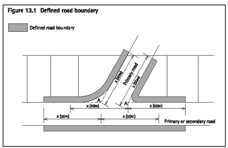
access near intersections - defined road boundary
Construction of any vehicle access across the 'defined
road boundary' as described below, and as shown on figure 13.1: Defined
road boundary, is a restricted discretionary activity. This rule applies
to:
- Any access from a primary road boundary,
which is within 50m of an intersection with any other primary road boundary.
Refer to figure 13.1.
- Any access from a primary road boundary,
which is within 50m of an intersection with any secondary road boundary.
Refer to figure 13.1.
- Any access from a road boundary
opposite any of the above road boundaries.
Note: The above distances will be measured as illustrated
by figure 13.1:
Matters of discretion
When considering an application to construct a vehicle
access across the 'defined road boundary', the council has restricted
its discretion to the following matters:
- The extent to which there are existing
traffic problems on adjacent roads.
- Whether the access is likely to cause
traffic congestion and/or conflict between pedestrian, cyclists and
vehicles.
- Whether the location of the access will
allow for adequate sight distances, or exacerbate present congestion
and traffic safety problems caused by ingress and egress of vehicles.
- Whether the accessway will be sufficiently
separated from pedestrian and cycle access to ensure safety of pedestrians
and cyclists.
Note: Vehicle crossing permits will also be required
from council for vehicle crossings between the carriageway and the property
boundary.
Notification requirements
For notification requirements, refer clause 13.5.
13.7 Rules - parking
and loading
13.7.1 Provision of
parking and loading spaces
The following are restricted discretionary activities:
- Any activity that does not comply with
the parking and loading rules.
- Any activity required to provide,
or where it is otherwise intended to provide, parking for more than
25 vehicles.
13.7.2 Number
of parking spaces to be provided
Every owner or occupier who constructs, substantially
reconstructs or adds to any building or changes the use of any site
must provide on-site parking in accordance with table 13.1: Number of
parking spaces required. For dwellings, these provisions will only apply
where there is an increase in the number of dwellings on the site.
Calculation of parking requirements
Where a particular site supports more than one activity,
the parking requirement of each activity must be determined and provided
for separately. The parking rates for the parts of an activity will
also be separately determined where separate rates are listed in
table
13.1. Where the parts of an activity have differing parking rates listed,
the highest rate will be applied to all the parts unless they are physically
and clearly defined.
If an activity is not represented in table 13.1, the
activity closest in nature to the new activity should be used, or where
there are two or more similar activities the activity with the higher
parking rate will apply. Alternatively application may be made for a
new rate through the resource consent process.
Table 13.1: Number of parking spaces required
| Activity |
Parking
spaces required |
| Art galleries and museums |
1 space for every 50m2
of gross floor area. |
| Accommodation for
care |
1 space for every
three residents the facility is designed to accommodate. 1 space for every two non-resident employees.
1 space for any manager's unit.
|
| Accommodation for
retired, elderly or disabled people |
1 space for every
five rest home beds. Excluding rest home beds, 1 space for every three
units or, where the accommodation provided is not in the form of units,
1 space for every three bedrooms.
1 visitor space for every five units or five bedrooms.
1 space for every two non-resident employees.
1 space for every resident caregiver.
|
| Boarding house or
hostel |
1 space for every
three residents the boarding house or hostel is designed to accommodate. 1 space for every two non-resident employees.
1 space for any manager's unit.
|
| Boarding kennels and
catteries |
1 space for animal
drop-off/pick-up purposes for every 20 animals the facility is designed
to accommodate. 1 space for every two non-resident employees.
|
| Camping facilities |
1 space for every
two camp sites. 1 space for every two non-resident employees.
1 space for any manager's unit.
|
| Care centre |
1 space for every
ten children or people the facility is designed to care for. 1 space for every two employees.
|
| Community facilities |
1 space for every four people
a public hall or recreation facility is designed to have capacity for,
or for churches, 1 space for every 4.5m2 of floor area of
the auditorium of the church or 1 for every 4.5m2 of the
total floor area of all meeting rooms (whichever is the greater). Provided
that the term auditorium means the primary place of assembly (including
any nave/congregational seating area) and any adjacent gallery or room
which is separated by non-permanent partitions, but does not include
any chancel, sanctuary or stage. |
| Dwellings |
1 space for each dwelling. |
| Educational facilities |
For primary and intermediate
schools: 1 space for every 15 students to be available for
the setting down and picking up of students, plus 1 space for every
two employees on the site.
For secondary schools:
1 space for every 30 students aged 15 years and
over, plus 1 space for every 30 students for the setting down and picking
up of students, plus 1 space for every two employees on the site.
For tertiary facilities:
1 space for every three students present on site
at any one time, plus 1 space for every two employees on the site.
|
| Entertainment facilities |
1 space for every three people
the facility is designed to have capacity for. |
| Function facilities |
1 space for every five people
the facility is designed to have capacity for. |
| Funeral parlours |
1 space for each employee, plus
where funeral services are performed (eg chapel) 1 space for every five
persons the facility is designed to have capacity for. |
| Healthcare services |
1 space for every 20m2
of gross floor area. |
| Home occupations |
1 space for home occupations
where retail sales are permitted.
1 space for any non-resident employee.
(In addition to the parking space required for
the dwelling)
|
| Homestays |
1 space for every three bedrooms
(used for the homestay). |
| Industry (excluding
wineries) |
1 space for every
50m2 of gross floor area plus, in the case of a motor vehicle
servicing premises, 4 spaces for each repair or lubrication bay. 1 space for every 100m2 of outdoor space
used for industrial purposes.
|
| Motor vehicle sales
|
1 space for every
20 vehicle display spaces. 1 space for each 50m2 of the gross floor
area of the remaining building used in the activity.
|
| Motor vehicle services |
4 spaces for each
repair or lubrication bay.
1 space for each 50m2 of the gross floor
area of the remaining building used in the activity.
|
| Offices |
1 space for every 50m2
of gross floor area. |
| Restaurants, cafes
and other eating places |
1 space for every
six customers the premises are designed to have capacity for. 1 space for every two staff employed on site or
operating from the site at any one time.
|
| Retail premises |
1 space for every
40m2 of gross floor area. 1 space for every 40m2 of outdoor retail.
1 space for every 80m2 of gross floor
area specifically set aside and used exclusively for staff amenity activities
(including staff cafeterias, staff rooms, staff recreation and ablution
uses).
1 space for every 80m2 of office and
storage space ancillary to the primary retail activity of the building.
|
| Service stations |
1 space for every
40m2 of gross floor area of retail shop. 1 space per two employees.
4 spaces for each repair or lubrication bay.
1 space per air hose or vacuum cleaner.
2 queuing spaces per car wash.
|
| Taverns |
1 space for every six persons
the tavern is designed to have capacity for. |
| Tourist complexes |
1 space for every
three units or, where the accommodation provided is not in the form
of units, 1 space for every three bedrooms. 1 space for every two employees.
1 space for every four customers the restaurant
is designed to have capacity for.
1 space for every five people the function facility
is designed to have capacity for.
|
| Visitor accommodation |
1 space for every
two non-residential employees. 1 space for every three units or, where the accommodation
provided is not in the form of units, 1 space for every three bedrooms.
1 space for any manager's unit.
|
| Wineries |
1 space for every
two employees. 1 space for every 50m2 of gross floor
area of retail shop.
|
The parking space requirements in table 13.1 include
any spaces required to be provided under the building code for people
with disabilities.
13.7.3 Number
of loading spaces to be provided
With the exception of service stations and truck stops,
every owner or occupier who constructs, substantially reconstructs,
or adds to any building in the commercial 1-7 or Matiatia land units,
or any activity elsewhere which generates delivery trips by heavy vehicles,
must provide off-road loading spaces in accordance with table 13.2:
Number of loading spaces to be provided.
For the purposes of this clause, truck stops are stand
alone facilities for the refuelling of heavy vehicles. It excludes facilities
for the retail sale or hire of any goods, or for the mechanical repair
and servicing of motor vehicles.
Table 13:2: Number of loading spaces required
| 1.
Industry, wineries and retail premises |
| Gross floor area of
activity |
Number of on-site loading
spaces to be provided |
| 0 - 5,000m2 |
1 space |
| 5,001 - 10,000m2 |
2 spaces |
| Over 10,000m2 |
2 spaces plus 1 space for every
additional 5,000m2 of gross floor area |
| 2.
Offices, visitor accommodation, healthcare services and other activities
not mentioned in (1) above
|
| Gross floor area of
activity |
Number of on-site loading
spaces to be provided |
| 0 - 20,000m2 |
1 space |
| 20,001 - 50,000m2 |
2 spaces |
| Over 50,000m2 |
2 spaces plus 1 space for every
additional 25,000m2 of gross floor area |
| 3.
Service stations and truck stops |
| No loading space is
required where it can be demonstrated that there is adequate space on
the forecourt of the service station or truck stop for loading activities
to take place without adversely affecting vehicle manoeuvring on the
site. |
13.7.4 Assessment
and formation of parking and loading areas
All parking and loading spaces must comply with the
following rules. Non-compliance with any of these rules is a restricted
discretionary activity.
- Fractional spaces
Where an assessment of the required parking and loading standards results
in a fractional space, any fraction under one half will be disregarded
and any fraction of one half or more will be counted as one space.
- Size of and access to parking and
loading spaces
Every parking and loading space must:
- Comply with the dimensions in figures
13.2: Manoeuvring and parking space requirements, table 13.3 Dimensions
for manoeuvring and parking spaces and figure 13.3: Preferred design
envelope around parked vehicle. Parking spaces that comply with the
preferred design envelope of figure 13.3 are considered to comply with
the requirements of figure 13.2 and table 13.3.
- Provide parking spaces of larger
dimensions than those specified in (a) above for use by disabled persons.
Parking spaces which meet the requirements of NZS 4121:1985 Code of
Practice for Design for Access and Use of Buildings and Facilities by
Disabled Persons will be considered to meet this requirement.
- Be provided with such access drives
and aisles as are necessary for ingress and egress of vehicles to and
from the road, and for the manoeuvring of vehicles within the site.
In determining the extent of area required for manoeuvring space, the
council will be guided by figure 13.4: 90 percentile car tracking curves
and figure 13.5: 90 percentile truck tracking curves.
In applying the tracking curves:
- The clearances identified in figures
13.4 and 13.5 must be maintained between the vehicle tracking area curve
and any fixed object.
- For public and customer carparking, the
90 percentile tracking curves will apply.
- Be located on the same site as the
activity to which it relates, be available at all times and have adequate
useable access to that activity or building. Each loading space must
be adjacent to an adequate area for goods handling and must be convenient
to any service area.
- Formation of parking and loading
spaces
The whole of the parking and loading space or spaces, access drives,
manoeuvring areas and aisles must, before the commencement of the activity
to which those parking and loading spaces relate, and for as long as
that activity is continued, be formed, provided with an all weather
surface, drained, marked out or delineated, and maintained.
- Availability of parking and loading
spaces
Required parking areas must be kept clear and available at all times,
free of charge and impediment, for vehicles used in conjunction with
the particular activity to which the parking spaces relate on the site,
and must not be used for the deposit or storage of any goods or materials
or for any other purpose.
- Screening of spaces
Screening must be provided where four or more outdoor parking spaces
provided on a site are adjacent to or visible from land which is in
the island residential or recreation land units or in a settlement area.
The spaces must be screened from the land in the island residential
or recreation land units or settlement areas by:
- A solid wall or fence not less than 1.8m
in height, built of concrete, brick, stone, timber or other solid material,
or;
- Densely planted indigenous vegetation
which is capable of reaching a minimum height of 1.8m and will screen
the parking spaces throughout the year.
- Kerbs
Where a parking or manoeuvring area on Waiheke is adjacent to a road,
then a kerb or similar barrier, not less than 150mm high and at least
600mm from the road boundary, must be provided on those parts of the
frontage not used for vehicular access.
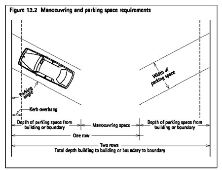
Table 13.3: Dimensions for manoeuvring
and parking spaces
All dimensions are in metres
| Parking
angle |
Width
of parking space |
Kerb
overhang |
Depth
of parking space |
Manoeuvring
space |
Total
depth one row |
Total
depth two rows |
| 90°
|
2.5 |
1.0 |
4.9
|
8.1 |
13 |
17.9 |
| 2.6 |
1.0 |
4.9 |
7.1 |
12 |
16.9 |
| 2.7 |
1.0 |
4.9 |
6.7 |
11.6 |
16.5 |
| >2.75 |
1.0 |
4.9 |
6.6 |
11.5 |
16.4 |
| 75° |
2.4 |
1.0 |
5.2 |
6.5 |
11.7 |
16.9 |
| 2.5 |
1.0 |
5.2 |
6.0 |
11.2 |
16.4 |
| 2.6 |
1.0 |
5.2 |
5.7 |
10.9 |
16.1 |
| 2.7 |
1.0 |
5.2 |
5.0 |
10.2 |
15.4 |
| >2.75 |
1.0 |
5.2 |
4.3 |
9.5 |
14.7 |
| 60° |
2.4 |
1.0 |
5.2 |
4.6 |
9.8 |
15.0 |
| 2.5 |
1.0 |
5.2 |
4.1 |
9.3 |
14.5 |
| 2.6 |
1.0 |
5.2 |
3.5 |
8.7 |
13.9 |
| 2.7 |
1.0 |
5.2 |
3.3 |
8.5 |
13.7 |
| >2.75 |
1.0 |
5.2 |
3.2 |
8.4 |
13.6 |
| 45° |
2.4 |
0.8 |
4.9 |
2.9 |
7.8 |
12.7 |
| 2.5 |
0.8 |
4.9 |
2.7 |
7.6 |
12.5 |
| 2.6 |
0.8 |
4.9 |
2.5 |
7.4 |
12.3 |
| 2.7 |
0.8 |
4.9 |
2.4 |
7.3 |
12.2 |
| >2.75 |
0.8 |
4.9 |
2.3 |
7.2 |
12.1 |
| 30° |
2.4 |
0.6 |
4.0 |
2.4 |
6.4 |
10.4 |
| 2.5 |
0.6 |
4.0 |
2.4 |
6.4 |
10.4 |
| 2.6 |
0.6 |
4.0 |
2.4 |
6.4 |
10.4 |
| 2.7 |
0.6 |
4.0 |
2.3 |
6.3 |
10.3 |
| >2.75 |
0.6 |
4.0 |
2.3 |
6.3 |
10.3 |
| Parallel |
5.9 |
0.4 |
2.5 |
3.6 |
6.1 |
8.6 |
| 6.1 |
0.4 |
2.5 |
3.3 |
5.8 |
8.3 |
| 6.3 |
0.4 |
2.5 |
3.0 |
5.5 |
8.0 |
Notes:
- This table should be used in conjunction
with figure 13.2: Manoeuvring and parking space requirements.
- Minimum aisle widths are 3.5m for
a one-way aisle, and 5.5m for a two-way aisle. Where an aisle serves
more than 50 spaces, it should be designed as a circulation route in
which case the minimum width for a two-way aisle increased to 6.5m.
- Stall widths must be increased by
0.3m where they abut obstructions such as columns or walls.
- All overhang areas must be kept
clear of objects greater than 150mm in height.
- Where parallel end spaces have direct
access through the end of the stall the length of the stall may be reduced
to 5.4m.
- One-way traffic is assumed for angle
spaces.
- Parking spaces must have a height
of at least 2.3m over the full area of the space, except where special
provision is made to divert overheight vehicles, in which case the minimum
height may be reduced to 2.1m.
- Parking spaces that comply with
the preferred design envelope of figure 13.3 are considered to comply
with the parking spaces dimensions in the table 13.3.
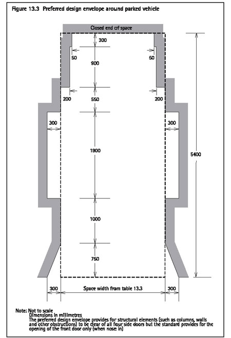
Figure 13.4
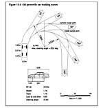 Image not to scale.
Click here for printable version of Figure 13.4 to correct scale.
Image not to scale.
Click here for printable version of Figure 13.4 to correct scale.
Figure 13.5
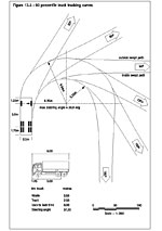 Image not to scale.
Click here for printable version of Figure 13.5 to correct scale.
Image not to scale.
Click here for printable version of Figure 13.5 to correct scale.
13.7.5 Matters
of discretion for a reduction in parking and loading spaces
When considering an application to reduce the number
of parking and loading spaces, the council has restricted its discretion
to considering the following matters:
- The availability of alternative modes
of transport for accessing the site.
- The effects of constructing the spaces
for which a reduction is sought - including any requirements for earthworks,
vegetation clearance, or other modification of natural features.
- Any travel demand management measures
proposed.
- The likely demand for the spaces.
- The physical practicality of providing
the required spaces, including any effect on the ability to provide
on-site effluent disposal.
- The availability of alternative spaces
in the vicinity.
- Any opportunities for sharing spaces with
other users.
Assessment criteria
The council's assessment of an application for a reduction
in parking and loading spaces will consider the following matters:
- Whether it can be demonstrated that a
substantial number of customers or users of the proposed activity will
access the site by using public transport, car-pooling, taxis, cycling,
or walking. Where an applicant can demonstrate that cycle facilities
are needed and will be used, a reduction of 1 parking space for every
8 spaces required may be approved where the applicant provides enclosed
secure parking facilities (eg bike lockers) for at least five bicycles.
- Whether provision of the required
number of spaces would necessitate the removal or modification of significant
vegetation or other significant natural features on the site and/or
require substantial earthworks having the potential for adverse land
stability, visual and landscape, and sediment runoff effects.
- Whether the application of any travel
demand management measures initiated by the applicant can demonstrably
reduce the requirement for on-site parking.
- Whether a demonstrably less than
normal demand for parking or loading will be generated by the proposal
- eg due to specific business practice, operating method (including
the provision of dedicated transport to/from the site by the operator),
type of customer.
- Whether provision of the required
number of spaces would compromise the ability to provide adequate on-site
effluent disposal due to the impervious surface required for parking
purposes.
- Whether or not it is physically
practicable to provide the required number of spaces on site in terms
of the existing location of buildings, availability of access to the
road, and other similar matters.
- Whether there is an adequate alternative
supply of parking in the vicinity - eg public carpark, formed angle
parking on adjacent roads. In general on-road parallel parking, particularly
in residential streets or roads with an important through-traffic function
in the roading hierarchy, is not considered a viable alternative.
- Whether there is an accessible and
adequate on-road loading space in close proximity or the ability to
create such a loading space.
- Whether other activities on the
same or nearby sites operate at different times and can share car parking
and/or loading spaces. In such a situation the council will require
a legal agreement between the applicant and owner of the site(s) confirming
such an arrangement.
Notification requirements
For notification requirements, refer clause 13.5.
13.7.6 Matters
of discretion for parking areas for more than 25 vehicles
When considering an application to provide parking for
more than 25 vehicles, the council has restricted its discretion to
considering the following matters:
- Opportunities for reducing the number
of parking spaces.
- The design of vehicle access to the parking
areas.
- The design of the internal vehicle circulation
and its safety and efficiency.
- The proximity of the parking area to residential
uses and any screening.
- The formation of the parking area.
Assessment criteria
The council's consideration of an application for parking
areas for more than 25 vehicles will consider the following matters:
- Whether the number of parking spaces
could be reduced, taking into account:
- The ability for customers or users of
the proposed activity to practicably access the site by using passenger
transport, cycling, or walking.
- Whether the proposed activity will generate
a demonstrably less than normal demand for parking - eg due to specific
business practice, operating method (including the provision of dedicated
transport to/from the site by the operator), type of customer.
- Any travel demand management measures.
- The extent to which vehicle access
to parking areas will be designed to:
- ensure adequate sight distances
- prevent congestion caused by ingress
and egress of vehicles
- provide adequate separation from pedestrian
access to ensure the safety of pedestrians.
- Whether the parking areas will be
designed to provide safe and efficient internal vehicle circulation.
- The extent to which parking areas
are to be located away from residential uses. Where this is impracticable,
adequate screening must be provided in the form of fencing and/or landscape
planting in order to prevent adverse noise, visual, or lighting effects
on adjoining residential uses.
- Whether the parking areas are properly
graded, formed to prevent dust nuisance and drained to prevent concentrated
runoff of water from the site.
Notification requirements
For notification requirements, refer clause 13.5.
13.7.7 Additional
matters of discretion for parking areas in landform and rural land units
Where more than 25 parking spaces are to be provided
on a site in the landform and rural land units, the council will consider
the effects of the additional traffic generated by the proposed activity.
When considering such applications, the council has restricted its discretion
to considering the following matters:
- The matters set out in clause 13.7.6.
- The adequacy of roads giving access
to the site, having regard to:
- Whether the current physical condition
of the roads and their function in the roading hierarchy can accommodate
the additional traffic generated by the activity.
- Whether the activity will adversely affect
the safety of road users, including cyclists and pedestrians.
- Any travel demand management measures
initiated by the applicant.
- The extent to which the traffic
generated by the activity has an effect on amenity values.
13.8 Rules - helipads and airstrips
13.8.1 Exceptions
Clauses 13.8.2 to 13.8.4 do not apply to:
- Helicopters or aircraft involved in emergency,
police or rescue operations.
- The existing Claris and Okiwi airstrips.
13.8.2 Permitted
activities
For Great Barrier only, helipads and airstrips in are
permitted in landform 1-7, where:
- No more than three inward and three outward
movements occur in a seven day period; and
- The noise from any landing area
does not exceed an Lmax of 85dBA measured at any adjacent
notional boundary with a residential use on an adjacent site.
13.8.3 Discretionary
activities
Helipad and airstrips are discretionary activities in
the following land units:
- Landform 1-7 - except as provided for
in clause 13.8.2.
- Rural 1-3 - provided they are used
for no more than three inward and three outward movements in a seven
day period.
- Pakatoa and Rotoroa - provided that
this is limited to one helipad or airstrip per island.
13.8.4 Non-complying
activities
Helipad and airstrips not provided for in clauses 13.8.1
to 13.8.3 above are non-complying activities.
13.8.5 Assessment
criteria for discretionary activities
The council's assessment of an application for a helipad
or airstrip as a discretionary activity will include consideration of
the following matters:
- The extent to which the helinoise boundary
meets or exceeds the limits of acceptability of table 1 of NZS 6807:1994
Noise Management and Land Use Planning for Helicopter Landing Areas.
- The extent to which the airnoise
boundary meets or exceeds the recommended noise control criteria of
table 1 of NZS 6805:1992 Airport Noise Management and Land Use Planning.
- Whether the type and size of the
facility to be provided gives rise to adverse visual, or amenity effects.
- Whether the noise impacts of the
proposal can be adequately mitigated so as not to give rise to adverse
aural and amenity effects.
- The extent to which the frequency
and timing of any use will give rise adverse effects.
- Whether the applicant proposes to
undertake monitoring and regular noise audits.
- The extent to which the aircraft
using the helipad or airstrip impacts on noise sensitive activities
or facilities.
- The hours of operation of the helipad
or airstrip.
Note: The council intends to investigate identifying
a specific helipad site on Rakino. A time limit should therefore be
considered for any resource consent that may be granted for a helipad
on Rakino where this occurs prior to the council identifying a specific
site.