District Plan Hauraki Gulf Islands Section - Proposed 2006
(Notified version 2006)
Street index |
Planning maps |
Text |
Appendices |
Annexures |
Section 32 material |
Plan modifications |
Help |
Notified - Home |
Decision - Home
Part 10a Land units: objectives, policies and activity tables
10a.1 Introduction
10a.2 Landform 1 (coastal cliffs and slopes)
10a.3 Landform 2 (dune systems and sand flats)
10a.4 Landform 3 (alluvial flats)
10a.5 Landform 4 (wetland systems)
10a.6 Landform 5 (productive land)
10a.7 Landform 6 (regenerating slopes)
10a.8 Landform 7 (forest and bush areas)
10a.9 Island residential 1 (traditional residential)
10a.10 Island residential 2 (bush residential)
10a.11 Commercial 1 (Oneroa village)
10a.12 Commercial 2 (Ostend village)
10a.13 Commercial 3 (local shops)
10a.14 Commercial 4 (visitor facilities)
10a.15 Commercial 5 (industrial)
10a.16 Commercial 6 (quarry)
10a.17 Commercial 7 (wharf)
10a.18 Matiatia (mixed use)
10a.19 Rural 1 (rural amenity)
10a.20 Rural 2 (western landscape)
10a.21 Rural 3 (Rakino amenity)
10a.22 Recreation 1 (local parks and esplanade reserves)
10a.23 Recreation 2 (community facilities and sports parks)
10a.24 Recreation 3 (Rangihoua Park)
10a.25 Conservation
10a.26 Pakatoa
10a.27 Rotoroa
10a.1 Introduction
This part of the Plan contains the objectives, policies,
activity tables and some rules applying to land identified on the planning
maps as being in a land unit. Each land unit also identifies issues,
and a strategy for how those issues will be addressed and the objectives
and policies achieved. The division into land units has been done by
grouping land according to common physical, locational, and development
characteristics.
The land units have been grouped as follows:
In this part, the land units appear in the same order
as given in the above table.
10a.2 Land unit
- Landform 1 (coastal cliffs and slopes)
10a.2.1 Introduction
This land unit is applied to steep coastal cliffs, exposed
coastal slopes and offshore islets and stacks.
Coastal cliffs and slopes is characterised by:
- A steep, rugged, wild and dynamic landscape
which defines the coastal margins.
- Visual prominence due to its exposed coastal
location.
- Sparse vegetation, including cliff associations
and unprotected remnant gully vegetation.
- Small pockets of grazed land, some of
which is regenerating.
- Instability, exposure, and varying degrees
of erosion.
- An absence of buildings or structures.
Overall, coastal cliffs and slopes has high natural
character values and a rugged, visually prominent landscape.
10a.2.2 Resource
management issue
The significant resource management issue which needs
to be addressed in the Plan is:
- How to protect the natural character and
visual prominence of the coastal cliffs and slopes from the adverse
effects of activities and buildings.
10a.2.3 Objective
To protect the natural character and visual prominence
of the coastal cliffs and slopes from the adverse effects of activities
and buildings.
Policies
- By protecting the coastal cliffs and
slopes from modification by activities and buildings.
- By requiring new sites to be of
a size and nature that avoids adverse effects on the natural character
and the visual prominence of the land unit.
10a.2.4 Resource
management strategy
The visual prominence and natural character value of
this land unit is so high, that the resource management strategy is
to not specifically provide for activities and buildings to occur at
all and to require a large minimum site size for subdivision within
the land unit.
10a.2.5 Rules
- activity table
Legend
P = Permitted
NC = Non-complying
Notes:
- The relationship between buildings and
other activities listed in the activity tables is explained in
clause
4.3.
- The activities of earthworks and
vegetation clearance are treated as development controls and are therefore
not listed in this table.
10a.2.6 Rules
- development controls
Refer to part 10c - Development controls for land units
and settlement areas for the controls applying in this land unit. The
development controls listed in that part apply to all activities, whether
or not those activities are otherwise permitted, restricted discretionary,
discretionary or non-complying. Infringements to these development controls
will be considered as development control modifications as set out in
clause 10c.3.
10a.2.7 Relationship
with rules in other parts of the Plan
Part 14 - Definitions must be referred to as it is likely
to contain definitions of terms used in this part of the Plan.
The following parts of the Plan should also be referred
to as they may contain rules which apply to a particular site or proposal:
- Part 4 - General rules
- Part 5 - Network utility services
- Part 6 - Financial contributions
- Part 7 - Heritage
- Part 8 - Natural hazards
- Part 9 - Hazardous facilities and contaminated land
- Part 10c - Development controls for land units and settlement areas
- Part 12 - Subdivision
- Part 13 - Connectivity and linkages
10a.3 Land unit
- Landform 2 (dune systems and sand flats)
10a.3.1 Introduction
Dune systems and sand flats is applied to open dune
systems and to sand flats which may be covered in pasture or other vegetation.
Dune systems and sand flats is characterised by:
- High natural character and visual amenity
value due to the open expansive qualities of the landscape, the coastal
location and the general absence of buildings and structures. This is
especially apparent in the dune systems area.
- A dynamic and variable nature, meaning
that the dune systems and sand flats continually change over time, though
some areas change faster than others.
- High ecological value due to the wildlife
habitats and plant species present.
- Sensitivity to modification by activities
and buildings, especially in the dune systems area.
- Varying degrees of instability, for example,
in some locations there are mobile sand dunes and in other locations
there are stable sand flats with regenerating vegetation cover.
- Pastoral farming as the dominant activity
if there is any activity at all.
Overall, the land unit has a dynamic and variable natural
environment, with high natural character, ecological and visual amenity
values.
10a.3.2 Resource
management issue
The significant resource management issue which needs
to be addressed in the Plan is:
- How to protect the natural character,
ecological and visual amenity value of the dune systems and sand flats
from the adverse effects of activities and buildings.
10a.3.3 Objective
To protect the natural character and the ecological
and visual amenity value of the dune systems and sand flats from the
adverse effects of activities and buildings.
Policies
- By protecting the natural character,
ecological and visual amenity value of the dune systems area of the
land unit from modification by activities and buildings.
- By limiting the activities that
can occur in the sand flats area of the land unit to those which avoid
adverse effects on the natural character, ecological and visual amenity
value of the land unit.
- By ensuring that the scale, form,
colour and location of new buildings in the sand flats area will not
have adverse effects on the natural character, ecological and visual
amenity value of the land unit.
- By requiring new sites to be of
a size and nature that avoids adverse effects on the natural character,
ecological and visual amenity value of the land unit.
10a.3.4 Resource
management strategy
As the dune systems area of the land unit needs a higher
degree of protection than the sand flats area, the resource management
strategy is to divide the land unit into two parts; the dune systems
area and the sand flats area.
In the dune systems area, the natural character, ecological
and visual amenity values are so high that buildings and activities
are not specifically provided for at all. In the sand flats area, the
range of activities is limited to those with a low intensity and buildings
require an assessment to ensure that there will be no adverse effects
on the natural character, ecological and visual amenity value of the
land unit.
10a.3.5 Rules
- activity tables
Landform 2 is divided into two areas:
- dune systems - the location of these is
identified with the symbol ‘ds’ on the planning maps
- sand flats - the location of these is
identified with the symbol ‘sf’ on the planning maps.
There is a separate activity table for each of these
areas.
10a.3.5.1 Dune systems
area
Legend
P = Permitted
NC = Non-complying
Notes:
- The relationship between buildings and
other activities listed in the activity tables is explained in
clause
4.3.
- The activities of earthworks and
vegetation clearance are treated as development controls and are therefore
not listed in this table.
10a.3.5.2 Sand
flats area
Legend
P = Permitted
RD = Restricted discretionary
D = Discretionary
Notes:
- In this land unit, the activities of
constructing or relocating buildings, or undertaking exterior alterations
and additions to existing buildings, are to be treated as separate from
the activity of using buildings for any of the permitted activities
listed in the table. Therefore, even when an activity is permitted in
this table, a resource consent may still be required for any construction
or relocation of, or any exterior alteration or addition to, the building
used for the activity. The relationship between buildings and other
activities listed in activity tables is explained further in
clause
4.3.
- The activities of earthworks and
vegetation clearance are treated as development controls and are therefore
not listed in this table.
10a.3.6 Rules
- standards and terms for multiple dwellings
An application for multiple dwellings will only be considered
as a discretionary activity where one or more of the following criteria
are met:
- The resulting number of dwellings on
the site will be no more than that which would occur if the site were
subdivided in accordance with the rules in Part 12 - Subdivision applying
to this land unit (with one dwelling per site).
- An application is made at the same
time for subdivision resulting in the amalgamation of sites such that
the number of dwellings on the new site created would be no greater
than that which could be achieved through locating a dwelling on each
of the original sites.
- The dwellings are for papakainga
housing.
- The land has been owned co-operatively
by a number of individuals since prior to 29 September 1992.
Proposals which do not meet these standards are a non-complying
activity.
10a.3.7 Rules
- development controls
Refer to Part 10c - Development controls for land units
and settlement areas for the controls applying in this land unit. The
development controls listed in that part apply to all activities, whether
or not those activities are otherwise permitted, restricted discretionary,
discretionary or non-complying. Infringements to these development controls
will be considered as development control modifications as set out in
clause 10c.3.
10a.3.8 Assessment
matters
For applications for resource consent refer to part 11 - Assessment matters for:
- Matters of discretion and notification
requirements applying to the construction and relocation of buildings
and to exterior alterations and additions to existing buildings.
- Assessment criteria for discretionary
activities.
10a.3.9 Relationship
with rules in other parts of the Plan
Part 14 - Definitions must be referred to as it is likely
to contain definitions of terms used in this part of the Plan.
The following parts of the Plan should also be referred
to as they may contain rules which apply to a particular site or proposal:
- Part 4 - General rules
- Part 5 - Network utility services
- Part 6 - Financial contributions
- Part 7 - Heritage
- Part 8 - Natural hazards
- Part 9 - Hazardous facilities and contaminated land
- Part 10c - Development controls for land units and settlement areas
- Part 12 - Subdivision
- Part 13 - Connectivity and linkages
10a.4 Land unit
- Landform 3 (alluvial flats)
10a.4.1 Introduction
This land unit is applied to low-lying pasture land
that is often located near dune systems and sand flats and wetland systems.
Alluvial flats is characterised by:
- Low-lying land with pasture as the main
vegetation cover.
- Pastoral farming and horticultural activities
that use the high productive capability of the alluvial soil. These
are often of a smaller scale than the productive activities occurring
within other land units.
- The character and amenity associated with
a rural landscape.
- High water tables and various water bodies
such as streams and wetlands.
- A working landscape with various built
elements such as farm buildings, houses and drainage systems.
Overall, alluvial flats provides for small scale rural
activities which contribute to the lifestyle, economy and identity of
the islands.
10a.4.2 Resource
management issues
The significant resource management issues which need
to be addressed in the Plan are:
- How to provide for productive activities,
such as pastoral farming and horticulture, to establish and operate
within in the land unit.
- How to recognise that productive
activities may need to be complemented by non-productive activities
to ensure that a reasonable economic return for the landowner is achieved.
- How to control the potential adverse
effects of non-productive activities so that the rural character of
the landscape and the general amenity of the area is maintained.
- How to manage the flooding which
results from the high water tables associated with the land unit.
10a.4.3 Objective
To provide for smaller scale productive activities and
a limited range of non-productive activities where they do not detract
from the rural character of the landscape or the general amenity of
the locality.
Policies
- By providing for productive activities,
such as pastoral farming and horticulture, to establish and operate
in the land unit.
- By requiring new sites to be of
a size and nature that ensures smaller scale rural activities can occur
and which maintains the rural character of the landscape.
- By ensuring that the scale, nature
and location of non-productive activities will not have adverse effects
on the rural character of the landscape or the general amenity of the
locality.
10a.4.4 Resource
management strategy
The resource management strategy is to provide for productive
activities, such as pastoral farming and horticulture, so that these
activities can continue to contribute to the economy, the lifestyle
and the identity of the islands.
The smaller minimum site size in this land unit recognises
that moderate to large scale farming operations may not always be viable
in the islands, and as such, landowners may need to diversify into a
wider range of productive activities, including those which do not require
large sites.
A limited range of non-productive activities is also
provided for, subject to ensuring that the rural character of the landscape
and general amenity values of the area are maintained. Provision for
such activities is appropriate given that the income from productive
activities may need to be supplemented and as the majority of this land
unit is located near settlement areas.
Visitor accommodation for up to 10 people is provided
for as a permitted activity. Visitor accommodation for more than 10
people is a discretionary activity so that adverse effects on the rural
character of the landscape and general amenity values of the locality
can be assessed.
The flooding issues associated with the land unit will
be managed through rules in part 8 - Natural hazards. This may mean
that while buildings are provided for in these land unit rules, they
may not be provided for under the natural hazard rules.
10a.4.5 Rules
- activity table
Legend
P = Permitted
D = Discretionary
Notes:
- The relationship between buildings and
other activities listed in activity tables is explained further in
clause
4.3.
- Commercial firewood harvesting and forestry are not expected to comply
with the vegetation clearance controls set out in part 10c - Development
controls for land units and settlement areas for landform 3.
- The activities of earthworks and
vegetation clearance (other than for commercial firewood harvesting
and forestry) are treated as development controls and are therefore
not listed in this table.
10a.4.6 Rules
- standards and terms for multiple dwellings
An application for multiple dwellings will only be considered
as a discretionary activity where one or more of the following criteria
are met:
- The resulting number of dwellings on
the site will be no more than that which would occur if the site were
subdivided in accordance with the rules in part 12 - Subdivision applying
to this land unit (with one dwelling per site).
- An application is made at the same
time for subdivision resulting in the amalgamation of sites such that
the number of dwellings on the new site created would be no greater
than that which could be achieved through locating a dwelling on each
of the original sites.
- The dwellings are for papakainga
housing.
- The land has been owned co-operatively
by a number of individuals since prior to 29 September 1992.
Proposals which do not meet these standards are a non-complying
activity.
10a.4.7 Rules
- development controls
Refer to part 10c - Development controls for land units
and settlement areas for the controls applying in this land unit. The
development controls listed in that part apply to all activities, whether
or not those activities are otherwise permitted, restricted discretionary,
discretionary or non-complying. Infringements to these development controls
will be considered as development control modifications as set out in
clause 10c.3.
10a.4.8 Assessment
matters
For applications for resource consent refer to part 11 - Assessment matters for assessment criteria for discretionary activities.
10a.4.9 Relationship
with rules in other parts of the Plan
Part 14 - Definitions must be referred to as it is likely
to contain definitions of terms used in this part of the Plan.
The following parts of the Plan should also be referred
to as they may contain rules which apply to a particular site or proposal:
- Part 4 - General rules
- Part 5 - Network utility services
- Part 6 - Financial contributions
- Part 7 - Heritage
- Part 8 - Natural hazards
- Part 9 - Hazardous facilities and contaminated land
- Part 10c - Development controls for land units and settlement areas
- Part 12 - Subdivision
- Part 13 - Connectivity and linkages
10a.5 Land unit
- Landform 4 (wetland systems)
10a.5.1 Introduction
This land unit is applied to fresh water wetlands that
drain to rivers, streams or estuaries and to areas of land that support
a prevalence of vegetation typically adapted for life in saturated soil
conditions.
Wetland systems is characterised by:
- Expansive, largely unmodified wetland
systems in low-lying areas.
- Smaller wetland systems, some of which
have been modified by land management practices on surrounding areas
of land.
- Wildlife and plant habitats, which result
in high ecological value in a local, regional and in some cases a national
context. This is particularly apparent where the wetland system is unmodified.
- High hydrological importance within water
catchments, particularly in terms of flood mitigation and sediment control.
- High natural character, especially where
the wetland system is unmodified.
Overall, wetland systems is an important natural environment,
with high natural character, ecological and hydrological values.
10a.5.2 Resource
management issue
The significant resource management issue which needs
to be addressed in the Plan is:
- How to protect the natural character,
ecological and hydrological value of wetland systems from the adverse
effects of activities and buildings.
10a.5.3 Objective
To protect the natural character and the ecological
and hydrological value of the wetland systems from the adverse effects
of activities and buildings.
Policies
- By protecting wetland systems from modification
by activities and buildings.
- By requiring new sites to be of
a size and nature that avoids adverse effects on the natural character,
ecological and hydrological value of the land unit.
10a.5.4 Resource
management strategy
The natural character, ecological and hydrological values
of this land unit are so high, that the resource management strategy
is to not specifically provide for activities and buildings to occur
at all and to require a large minimum site size for subdivision within
the land unit.
10a.5.5 Rules
- activity table
Legend
P = Permitted
NC = Non-complying
Notes:
- The relationship between buildings and
other activities listed in activity tables is explained in
clause 4.3.
- The activities of earthworks and
vegetation clearances are treated as development controls and are therefore
not listed in this table.
10a.5.6 Rules
- development controls
Refer to part 10c - Development controls for land units
and settlement areas for the controls applying in this land unit. The
development controls listed in that part apply to all activities, whether
or not those activities are otherwise permitted, restricted discretionary,
discretionary or non-complying. Infringements to these development controls
will be considered as development control modifications as set out in
clause 10c.3.
10a.5.7 Relationship
with rules in other parts of the Plan
Part 14 - Definitions must be referred to as it is likely
to contain definitions of terms used in this part of the Plan.
The following parts of the Plan should also be referred
to as they may contain rules which apply to a particular site or proposal:
- Part 4 - General rules
- Part 5 - Network utility services
- Part 6 - Financial contributions
- Part 7 - Heritage
- Part 8 - Natural hazards
- Part 9 - Hazardous facilities and contaminated land
- Part 10c - Development controls for land units and settlement areas
- Part 12 - Subdivision
- Part 13 - Connectivity and linkages
10a.6 Land unit
- Landform 5 (productive land)
10a.6.1 Introduction
This land unit applies to land with pasture cover as
the main vegetation type.
Productive land is characterised by:
- Pastoral and horticultural activities,
these are often of a moderate to large scale as compared to the productive
activities occurring within other land units.
- Varying contours, with some areas being
characterised as 'rolling to moderately sloping' and others being 'steep
slopes'.
- An expansive landscape with an open pattern
and a rural character.
- A range of pasture quality and productive
capability due to the varying soil types.
- A number of natural features such as smaller
wetlands and water systems.
- A working landscape with various built
elements such as farm buildings, houses and drainage systems.
Overall, productive land provides for large scale rural
activities which contribute to the lifestyle, economy and identity of
the islands.
10a.6.2 Resource
management issues
The significant resource management issues which need
to be addressed in the Plan are:
- How to provide for productive activities,
such as pastoral farming and horticulture, to establish and operate
within in the land unit.
- How to maintain the expansive nature,
the open pattern and rural character of the landscape.
10a.6.3 Objective
To provide for productive activities and to ensure that
the expansive nature, the open pattern and rural character of the landscape
is maintained.
Policies
- By providing for productive activities,
such as pastoral farming and horticulture to establish and operate within
the land unit.
- By limiting the non-productive activities
that can occur so that the rural use and character of the landscape
is maintained.
- By requiring new sites to be of
a size and nature which ensures that moderate to large scale productive
activities can occur and which protects the expansive nature, open pattern
and rural character of the landscape.
10a.6.4 Resource
management strategy
The resource management strategy is to provide for productive
activities, such as pastoral farming and horticulture, so that these
activities can continue to contribute to the economy, lifestyle and
the identity of the islands.
Provision for non-productive activities is limited and
the minimum site size is large so that the objective of using the land
for productive activities will be achieved.
10a.6.5 Rules
- activity table
Legend
P = Permitted
D = Discretionary
Notes:
- The relationship between buildings and
other activities listed in activity tables is explained in
clause 4.3.
- Commercial firewood harvesting and forestry are not expected to comply
with the vegetation clearance controls set out in part 10c - Development
controls for land units and settlement areas for landform 5.
- The activities of earthworks and
vegetation clearance (other than for commercial firewood harvesting
and forestry) are treated as development controls and are therefore
not listed in this table.
10a.6.6 Rules
- standards and terms for multiple dwellings
An application for multiple dwellings will only be considered
as a discretionary activity where one or more of the following criteria
are met:
- The resulting number of dwellings on
the site will be no more than that which would occur if the site were
subdivided in accordance with the rules in part 12 - Subdivision applying
to this land unit (with one dwelling per site).
- An application is made at the same
time for subdivision resulting in the amalgamation of sites such that
the number of dwellings on the new site created would be no greater
than that which could be achieved through locating a dwelling on each
of the original sites.
- The dwellings are for papakainga
housing.
- The land has been owned co-operatively
by a number of individuals since prior to 29 September 1992.
Proposals which do not meet these standards are a non-complying
activity.
10a.6.7 Rules
- development controls
Refer to part 10c - Development controls for land units
and settlement areas for the controls applying in this land unit. The
development controls listed in that part apply to all activities, whether
or not those activities are otherwise permitted, restricted discretionary,
discretionary or non-complying. Infringements to these development controls
will be considered as development control modifications as set out in
clause 10c.3.
10a.6.8 Assessment
matters
For applications for resource consent refer to part 11 - Assessment matters for assessment criteria for discretionary activities.
10a.6.9 Relationship
with rules in other parts of the Plan
Part 14 - Definitions must be referred to as it is likely
to contain definitions of terms used in this part of the Plan.
The following parts of the Plan should also be referred
to as they may contain rules which apply to a particular site or proposal:
- Part 4 - General rules
- Part 5 - Network utility services
- Part 6 - Financial contributions
- Part 7 - Heritage
- Part 8 - Natural hazards
- Part 9 - Hazardous facilities and contaminated land
- Part 10c - Development controls for land units and settlement
areas
- Part 12 - Subdivision
- Part 13 - Connectivity and linkages
10a.7 Land unit
- Landform 6 (regenerating slopes)
10a.7.1 Introduction
This land unit is applied to extensive areas of regenerating
bush where kanuka and manuka are the predominant vegetation.
Regenerating slopes is characterised by:
- High natural character and visual amenity
value, as a result of its visual prominence (in both coastal locations
and as a backdrop to settlement areas) and its unbroken expansive qualities.
- Varying rates of regeneration due to differences
in factors such as soil quality and stability, aspect and exposure.
- High ecological values, especially in
areas where the regenerating vegetation has been long established and
consequently there is an increased diversity of podocarp and broadleaf
species and wildlife habitats.
- Small, scattered and unobtrusive buildings,
if there are buildings at all.
- Isolated pockets of erosion particularly
on north facing slopes.
Overall, regenerating slopes makes a significant contribution
to the natural character, ecological and the visual amenity value of
the islands.
10a.7.2 Resource
management issue
The significant resource management issue which needs
to be addressed in the Plan is:
- How to protect the natural character,
ecological and visual amenity value of the regenerating slopes from
the adverse effects of activities and buildings.
10a.7.3 Objective
To protect the natural character, ecological and visual
amenity value of the regenerating slopes from the adverse effects of
activities and buildings.
Policies
- By limiting the activities that can occur
to those which avoid adverse effects on the natural character, ecological
and visual amenity value of the land unit.
- By ensuring that the scale, form,
colour and location of new buildings does not have adverse effects on
the natural character, ecological and visual amenity value of the land
unit.
- By requiring new sites to be of
a size and nature that protects the natural character, ecological and
visual amenity value of the land unit.
10a.7.4 Resource
management strategy
The resource management strategy is to limit activities
to those of a low intensity and to require buildings to be assessed
to ensure that there will be no adverse effects on the natural character,
ecological and visual amenity value of the land unit.
10a.7.5 Rules
- activity table
Legend
P = Permitted
RD = Restricted discretionary
D = Discretionary
Notes:
- In this land unit, the activities of
constructing or relocating buildings, or undertaking exterior alterations
and additions to existing buildings, are to be treated as separate from
the activity of using buildings for any of the permitted activities
listed in the table. Therefore, even when an activity is permitted in
this table, a resource consent may still be required for any construction
or relocation of, or any exterior alteration or addition to, the building
used for the activity. The relationship between buildings and other
activities listed in activity tables is explained further in
clause
4.3.
- The activities of earthworks and
vegetation clearance are treated as development controls and are therefore
not listed in this table.
10a.7.6 Rules
- standards and terms for multiple dwellings
An application for multiple dwellings will only be considered
as a discretionary activity where one or more of the following criteria
are met:
- The resulting number of dwellings on
the site will be no more than that which would occur if the site were
subdivided in accordance with the rules in part 12 - Subdivision applying
to this land unit (with one dwelling per site).
- An application is made at the same
time for subdivision resulting in the amalgamation of sites such that
the number of dwellings on the new site created would be no greater
than that which could be achieved through locating a dwelling on each
of the original sites.
- The dwellings are for papakainga
housing.
- The land has been owned co-operatively
by a number of individuals since prior to 29 September 1992.
Proposals which do not meet these standards are a non-complying
activity.
10a.7.7 Rules - development controls
Refer to part 10c - Development controls for land units
and settlement areas for the controls applying in this land unit. The
development controls listed in that part apply to all activities, whether
or not those activities are otherwise permitted, restricted discretionary,
discretionary or non-complying. Infringements to these development controls
will be considered as development control modifications as set out in
clause 10c.3.
10a.7.8 Assessment
matters
For applications for resource consent refer to part 11 - Assessment matters for:
- Matters of discretion and notification
requirements applying to the construction and relocation of buildings
and to exterior alterations and additions to existing buildings.
- Assessment criteria for discretionary
activities.
10a.7.9 Relationship
with rules in other parts of the Plan
Part 14 - Definitions must be referred to as it is likely
to contain definitions of terms used in this part of the Plan.
The following parts of the Plan should also be referred
to as they may contain rules which apply to a particular site or proposal:
- Part 4 - General rules
- Part 5 - Network utility services
- Part 6 - Financial contributions
- Part 7 - Heritage
- Part 8 - Natural hazards
- Part 9 - Hazardous facilities and contaminated land
- Part 10c - Development controls for land units and settlement areas
- Part 12 - Subdivision
- Part 13 - Connectivity and linkages
10a.8 Land unit
- Landform 7 (forest and bush areas)
10a.8.1 Introduction
Forest and bush areas include extensive podocarp and
broadleaf forest areas, areas of secondary regenerating forest and some
isolated areas of manuka and kanuka.
Forest and bush areas are characterised by:
- Steep upper slopes and valley systems
with some gently sloping areas.
- High conservation and ecological value
as these areas have either survived or significantly recovered from
milling activity in the past.
- High natural character and visual amenity
due to the sheer dominance, scale and age of the vegetation cover.
- An absence of built structures.
Overall, forest and bush areas make a significant contribution
to the natural character, conservation, ecological and visual amenity
values of the islands.
10a.8.2 Resource
management issue
The significant resource management issue which needs
to be addressed in the Plan is:
- How to protect the natural character and
the conservation, ecological and visual amenity value of the forest
and bush areas from adverse effects of activities and buildings.
10a.8.3 Objective
To protect the natural character and the conservation,
ecological and visual amenity values of forest and bush areas from the
adverse effects of activities and buildings.
Policies
- By limiting the activities that can occur
to those which avoid adverse effects on the natural character and the
conservation, ecological and visual amenity value of the land unit.
- By ensuring that the scale, form,
colour and location of new buildings will not have adverse effects on
the natural character and the conservation, ecological and visual amenity
value of the land unit.
- By requiring new sites to be of
a size and nature that protects the natural character and the conservation,
ecological and visual amenity value of the land unit.
10a.8.4 Resource
management strategy
The resource management strategy is to limit activities
to those of a low intensity and to require buildings to be assessed
to ensure that there will be no adverse effects on the natural character
and the conservation, ecological and visual amenity value of the land
unit.
10a.8.5 Rules
- activity table
Legend
P = Permitted
RD = Restricted discretionary
D = Discretionary
Notes:
- In this land unit, the activities of
constructing or relocating buildings, or undertaking exterior alterations
and additions to existing buildings, are to be treated as separate from
the activity of using buildings for any of the permitted activities
listed in the table. Therefore, even when an activity is permitted in
this table, a resource consent may still be required for any construction
or relocation of, or any exterior alteration or addition to, the building
used for the activity. The relationship between buildings and other
activities listed in activity tables is explained further in
clause
4.3.
- The activities of earthworks and
vegetation clearance are treated as development controls and are therefore
not listed in this table.
10a.8.6 Rules
- standards and terms for multiple dwellings
An application for multiple dwellings will only be considered
as a discretionary activity where one or more of the following criteria
are met:
- The resulting number of dwellings on
the site will be no more than that which would occur if the site were
subdivided in accordance with the rules in part 12 - Subdivision applying
to this land unit (with one dwelling per site).
- An application is made at the same
time for subdivision resulting in the amalgamation of sites such that
the number of dwellings on the new site created would be no greater
than that which could be achieved through locating a dwelling on each
of the original sites.
- The dwellings are for papakainga
housing.
- The land has been owned co-operatively
by a number of individuals since prior to 29 September 1992.
Proposals which do not meet these standards are a non-complying
activity.
10a.8.7 Rules
- development controls
Refer to part 10c - Development controls for land units
and settlement areas for the controls applying in this land unit. The
development controls listed in that part apply to all activities, whether
or not those activities are otherwise permitted, restricted discretionary,
discretionary or non-complying. Infringements to these development controls
will be considered as development control modifications as set out in
clause 10c.3.
10a.8.8 Assessment
matters
For applications for resource consent refer to part 11 - Assessment matters for:
- Matters of discretion and notification
requirements applying to the construction and relocation of buildings
and to exterior alterations and additions to existing buildings
- Assessment criteria for discretionary
activities.
10a.8.9 Relationship
with rules in other parts of the Plan
Part 14 - Definitions must be referred to as it is likely
to contain definitions of terms used in this part of the Plan.
The following parts of the Plan should also be referred
to as they may contain rules which apply to a particular site or proposal:
- Part 4 - General rules
- Part 5 - Network utility services
- Part 6 - Financial contributions
- Part 7 - Heritage
- Part 8 - Natural hazards
- Part 9 - Hazardous facilities and contaminated land
- Part 10c - Development controls for land units and settlement areas
- Part 12 - Subdivision
- Part 13 - Connectivity and linkages
10a.9 Land unit
- Island residential 1 (traditional residential)
10a.9.1 Introduction
This land unit is located in western Waiheke adjoining
or close to the commercial centre of villages and on four distinct areas
in Rakino. It contains the most intensive form of residential development
within the islands.
The characteristics of the land unit are:
- Low intensity residential development
(compared with the Auckland isthmus) containing stand alone dwellings.
- A highly modified, open and spacious landscape
(in most of the land unit a large proportion of each site is covered
in grass).
- A low proportion of indigenous vegetation.
- Flat or a moderate sloped topography.
The land unit also includes coastal terraces adjacent
to the more accessible and heavily used beaches on Waiheke.
Overall, the land unit is important as a residential
area with an open and spacious character.
10a.9.2 Resource
management issues
The significant resource management issues which need
to be addressed in the Plan are:
- How to provide for residential development
while maintaining the character and amenity of the area.
- How to ensure that non-residential
activities do not adversely impact on the amenity of residential areas.
10a.9.3 Objectives
and policies
10a.9.3.1 Objective
To provide for residential development at a scale and
intensity which maintains the relatively spacious character, increases
the indigenous vegetation cover and allows for effective stormwater
and wastewater disposal within the land unit.
Policies
- By controlling the intensity, bulk, scale
and location of buildings on sites in order to retain the character
of the land unit.
- By requiring the planting of sites
for amenity and wastewater disposal purposes.
10a.9.3.2 Objective
To provide for appropriate non-residential activities
where their scale, intensity and location are compatible with the residential
character of the area.
Policies
- By providing for activities which have
functions which are compatible with, and support residential activities.
- By ensuring that the character and
scale of buildings used for non-residential activities are compatible
with the amenities and character of the surrounding residential area.
- By restricting the type and intensity
of non-residential activities to those which are compatible in visual
amenity terms and in other generated effects (eg traffic, noise, hours
of operation) with surrounding residential uses.
10a.9.3.3 Objective
To maintain the amenity and landscape qualities of beach
front locations at Oneroa, Palm Beach, Blackpool and Onetangi.
Policies
- By imposing additional controls on all
buildings in the coastal amenity area so they do not compromise the
character and amenity of the coast.
- By only allowing non-residential
activities within coastal areas where they are compatible with the character
and amenity of these locations.
10a.9.4 Resource
management strategy
The resource management strategy for the land unit is
to provide for predominantly residential uses in the land unit and to
recognise the need to more carefully manage the environmental impacts
of such activities.
Coastal areas within the land unit are especially sensitive
to the effects of future development. This is controlled by identifying
a coastal amenity area which is shown on the planning maps. Development
within this area requires a resource consent.
10a.9.5 Rules
- activity table
Notes:
- In this land unit, the activities of
constructing or relocating buildings, or undertaking exterior alterations
and additions to existing buildings, are to be treated as separate from
the activity of using buildings for any of the permitted activities
listed in the table. Therefore, even when an activity is permitted in
this table, a resource consent may still be required for any construction
or relocation of, or any exterior alteration or addition to, the building
used for the activity. The relationship between buildings and other
activities listed in activity tables is explained further in
clause
4.3.
- The activities of earthworks and
vegetation clearance are treated as development controls and are therefore
not listed in this table.
10a.9.6 Rules
- development controls
The development controls listed below apply to all activities
whether or not those activities are otherwise permitted, restricted
discretionary, discretionary or non-complying. Infringements to these
development controls will be considered as development control modifications
as set out in clause 10c.3.
As well as the specific controls set out below, there
are additional controls set out in Part 10c - Development controls for
land units and settlement areas which also apply to this land unit.
10a.9.6.1 Planting
of front yards
On sites other than rear sites, not less than 60 per
cent of the 4m front yard must be planted (with ecosourced species where
practicable).
10a.9.6.2 Planting
of wastewater disposal areas
On all sites, planting of the wastewater disposal area
must be undertaken. Appendix 13 - Planting guide, identifies vegetation
that is appropriate for planting within effluent disposal fields.
10a.9.7 Assessment
matters
- Matters of discretion for dairies
When considering an application for resource consent
for a dairy, the council has restricted its discretion to considering
the following matters:
- traffic generation
- noise generation
- hours of operation
- the effect of the activity on the amenity
of surrounding residential uses with respect to the above.
- Other listed activities
For other applications for resource consent refer
to part 11 - Assessment matters for:
- Matters of discretion and notification
requirements applying to the construction and relocation of buildings
and to exterior alterations and additions to existing buildings
- Assessment criteria for discretionary
activities.
10a.9.8 Relationship
with rules in other parts of the Plan
Part 14 - Definitions must be referred to as it is likely
to contain definitions of terms used in this part of the Plan.
The following parts of the Plan should also be referred
to as they may contain rules which apply to a particular site or proposal:
- Part 4 - General rules
- Part 5 - Network utility services
- Part 6 - Financial contributions
- Part 7 - Heritage
- Part 8 - Natural hazards
- Part 9 - Hazardous facilities and contaminated land
- Part 10c - Development controls for land units and settlement
areas
- Part 12 - Subdivision
- Part 13 - Connectivity and linkages
10a.10 Land unit
- Island residential 2 (bush residential)
10a.10.1 Introduction
This land unit is located in western Waiheke and generally
adjoins the island residential 1 land unit.
The characteristics of the land unit are:
- Moderate to relatively steep slopes.
- Low intensity residential development
(compared with the Auckland isthmus) containing stand alone dwellings.
- Heavily bush covered with generally indigenous
vegetation.
- High ecological values.
- Dwellings which are a secondary component
of the landscape. Most dwellings blend into the dominant natural character
of the indigenous vegetation.
Overall, the land unit is an important residential area
with a character which is strongly influenced by indigenous vegetation.
10a.10.2 Resource
management issues
The significant resource management issues which need
to be addressed in the Plan are:
- How to ensure that buildings complement
the predominant elements of the natural landscape of indigenous vegetation
and steep topography.
- How to conserve indigenous vegetation
to maintain ecological values and the visual amenity of the land unit.
- How to ensure that non-residential
activities do not adversely impact on the amenity of residential areas.
10a.10.3 Objectives
and policies
10a.10.3.1 Objective
To control residential development and limit non-residential
activities to a scale, location, intensity and appearance which is complementary
to the bush clad character of the natural environment.
Policies
- By controlling the intensity of development
and the bulk, scale and location of buildings to ensure that they are
compatible with the natural environment.
- By assessing the design and appearance
of buildings to ensure that they are integrated with the natural environment.
- By restricting the type and intensity
of non-residential activities to those which are compatible in visual
amenity terms and in other generated effects (eg traffic, noise, hours
of operation) with surrounding residential uses and the natural environment.
10a.10.3.2 Objective
To ensure that development of sites retains indigenous
vegetation cover.
Policies
- By requiring the maximum amount of indigenous
vegetation to be retained.
- By ensuring that any development
is located on portions of the site that are of lower ecological value.
10a.10.4 Resource
management strategy
The resource management strategy for the land unit is
to provide for residential development at an intensity and scale, and
of an appearance, which does not detract from the dominant indigenous
bush clad character of the land unit. To ensure that this is achieved,
building development within this land unit requires a resource consent.
10a.10.5 Rules
- activity table
Legend
P = Permitted
RD = Restricted discretionary
D = Discretionary
Notes:
- In this land unit, the activities of
constructing or relocating buildings, or undertaking exterior alterations
and additions to existing buildings, are to be treated as separate from
the activity of using buildings for any of the permitted activities
listed in the table. Therefore, even when an activity is permitted in
this table, a resource consent may still be required for any construction
or relocation of, or any exterior alteration or addition to, the building
used for the activity. The relationship between buildings and other
activities listed in activity tables is explained further in
clause
4.3.
- The activities of earthworks and
vegetation clearance are treated as development controls and are therefore
not listed in this table.
10a.10.6 Rules
- development controls
Refer to part 10c - Development controls for land units
and settlement areas for the controls applying in this land unit. The
development controls listed in that part apply to all activities, whether
or not those activities are otherwise permitted, restricted discretionary,
discretionary or non-complying. Infringements to these development controls
will be considered as development control modifications as set out in
clause 10c.3.
10a.10.7 Assessment
matters
- Matters of discretion for dairies
When considering an application for resource consent
for a dairy, the council has restricted its discretion to considering
the following matters:
- traffic generation
- noise generation
- hours of operation
- the effect of the activity on the amenity
of surrounding residential uses with respect to the above.
- Other listed activities
For other applications for resource consent refer
to part 11 - Assessment matters for:
- Matters of discretion and notification
requirements applying to the construction and relocation of buildings
and to exterior alterations and additions to existing buildings
- Assessment criteria for discretionary
activities.
10a.10.8 Relationship
with rules in other parts of the Plan
Part 14 - Definitions must be referred to as it is likely
to contain definitions of terms used in this part of the Plan.
The following parts of the Plan should also be referred
to as they may contain rules which apply to a particular site or proposal:
- Part 4 - General rules
- Part 5 - Network utility services
- Part 6 - Financial contributions
- Part 7 - Heritage
- Part 8 - Natural hazards
- Part 9 - Hazardous facilities and contaminated land
- Part 10c - Development controls for land units and settlement
areas
- Part 12 - Subdivision
- Part 13 - Connectivity and linkages
10a.11 Land unit
- Commercial 1 (Oneroa village)
10a.11.1 Introduction
This land unit applies to the retail and commercial
area of Oneroa village on Waiheke.
The characteristics of the land unit are:
- Generally small scale retail and other
commercial activities (shops, cafés, restaurants and offices) located
in one to two storey buildings on small sites.
- Some community facilities (Artworks, Red
Cross).
- A variety of small to medium scale tenancies.
- Most buildings are located on or close
to Ocean View Road (and often include verandahs and landscaping).
- Relatively high volumes of traffic.
- Most of the activities within the land
unit are connected to, or able to be connected to, the Owhanake wastewater
treatment plant.
Oneroa village is a busy shopping centre which is a
focal point for local residents, shopping, recreation and socialising.
Its location within walking distance of Matiatia and on a major transport
route to the eastern parts of the island means that it has a major role
in servicing the needs of residents, commuters and visitors.
Oneroa is also situated in a dominant location on a
ridge overlooking, and with pedestrian and vehicle connections to, Oneroa
Beach.
The above characteristics contribute to the high amenity
value of the village.
Overall, Oneroa is an important retail and commercial
centre with a high level of amenity.
10a.11.2 Resource
management issues
The significant resource management issues which need
to be addressed in the Plan are:
- How to enable retail and employment opportunities
within Oneroa in a manner which protects and enhances the high amenity
value and 'village' character of the centre.
- How to ensure that commercial activity
within Oneroa village does not negatively impact on other activities
within the land unit or adversely affect the character and amenity of
adjoining island residential land units.
10a.11.3 Objectives
and policies
10a.11.3.1 Objective
To enable a vibrant, varied and safe retail environment
within Oneroa village where the scale, form and location of buildings
provides a high level of amenity.
Policies
- By requiring new buildings or additions
and alterations to existing buildings to be assessed to ensure consistency
with design guidelines for Oneroa (refer to appendix 12 - Oneroa village
design guidelines).
- By requiring retail activities to
locate on the ground floor to ensure an active and continuous retail
frontage is maintained.
- By requiring, on sites which adjoin
Ocean View Road, that new buildings adjoin and face this road, to ensure
an active and continuous retail frontage.
- By requiring verandahs to be provided
as shelter for pedestrians.
10a.11.3.2 Objective
To allow for appropriate commercial growth and development
within Oneroa village.
Policies
- By recognising that the scale of development
within Oneroa village is no longer constrained by wastewater disposal
due to the Owhanake wastewater treatment plant.
- By providing for a range of commercial
and residential activity within the village.
10a.11.3.3 Objective
To ensure that any adverse environmental effect of business
activity on other activities within the land unit or on adjoining island
residential or recreation land units is avoided or no more than minor
in extent.
Policies
- By requiring noise standards on all activities
and internal noise controls for dwellings within the land unit.
- By imposing additional controls
on the location and size of buildings where they adjoin or face island
residential or recreation land units.
10a.11.4 Resource
management strategy
The resource management strategy for the land unit is
to allow a diverse range of retailing and commercial activities while
controlling the design, scale and form of buildings to ensure that they
are of a high amenity value and do not adversely affect adjoining island
residential land units.
This will be undertaken by requiring that the construction
of, or addition to, buildings within the land unit undergo a resource
consent process.
10a.11.5 Rules
- activity table
Legend
P = Permitted
RD = Restricted discretionary
D = Discretionary
Notes:
- In this land unit, the activities of
constructing or relocating buildings, or undertaking exterior alterations
and additions to existing buildings, are to be treated as separate from
the activity of using buildings for any of the permitted activities
listed in the table. Therefore, even when an activity is permitted in
this table, a resource consent may still be required for any construction
or relocation of, or any exterior alteration or addition to, the building
used for the activity. The relationship between buildings and other
activities listed in activity tables is explained further in
clause
4.3.
- The activities of earthworks and
vegetation clearance are treated as development controls and are therefore
not listed in this table.
10a.11.6 Rules
- standards and terms for multiple dwellings
An application for multiple dwellings will only be considered
as a discretionary activity where one or more of the following criteria
are met:
- The resulting number of dwellings on
the site will be no more than that which would occur if the site were
subdivided in accordance with the rules in part 12 - Subdivision applying
to this land unit (with one dwelling per site).
- An application is made at the same
time for subdivision resulting in the amalgamation of sites such that
the number of dwellings on the new site created would be no greater
than that which could be achieved through locating a dwelling on each
of the original sites.
- The dwellings are for papakainga
housing.
- The land has been owned co-operatively
by a number of individuals since prior to 29 September 1992.
Proposals which do not meet these standards are a non-complying
activity.
10a.11.7 Rules
- development controls
The development controls listed below apply to all activities
whether or not those activities are otherwise permitted, restricted
discretionary, discretionary or non-complying. Infringements to these
development controls will be considered as development control modifications
as set out in clause 10c.3.
As well as the specific controls set out below, there
are additional controls set out in Part 10c - Development controls for
land units and settlement areas which also apply to this land unit.
10a.11.7.1 Building
location
Buildings on sites with frontage to Ocean View Road
must:
- Be built up to the Ocean View Road boundary
for the entire length of the road frontage of the site.
- Provide a verandah along the full
extent of the site frontage. The verandah must:
- Be so related to its neighbours as to
provide continuous pedestrian cover.
- Have a minimum height of 3m and
a maximum height of 4m above the footpath immediately below.
- Be set no further back than 600mm
in plan view from the kerbline.
This provision is supplementary to and not in
substitution for any of the council's bylaw requirements relating to
verandahs.
- Contain display areas or windows
on a minimum of 75 per cent of the site frontage at road level.
10a.11.7.2 Retail
frontage control
Within buildings on sites with frontage to Ocean View
Road, non-retail activities must not be located at street level (except
for entrances or access to such activities) unless retail fronts the
street and the non-retail activity is located behind it.
Restaurants, cafes and other eating places will be considered
as retail for the purpose of this rule.
Explanation
The retail frontage control seeks to ensure that non-retail
activities are located appropriately to maintain an active retail ground
floor and to ensure the retail character of Oneroa village is maintained.
This rule will retain the vitality, connectiveness and
interaction of Oneroa village while allowing non-retail activity in
appropriate locations.
10a.11.7.3 Internal
noise control for residential units
- All dwellings must be designed and constructed
so as to provide an indoor design level of balanced noise criterion
(NCB) 30 in any habitable room assuming the building is exposed to a
noise level of 55dBA Leq at the boundary of the site.
- The NCB level of 30 must be achieved
with windows and doors open unless adequate alternative ventilation
is provided to the requirements of clause G4 of the New Zealand Building
Code.
- Building elements (ie walls, floors)
which are common between different activities must be constructed to
prevent noise transmission to the requirements of clause G6 of the New
Zealand Building Code.
- After completion of the construction
of the dwelling(s), and before the issue of the code compliance certificate,
the consent holder must submit a report to the satisfaction of the council,
which is signed by a suitably qualified acoustic engineer, which certifies
that the dwelling(s) have been built in compliance with the noise and
ventilation requirements above.
Explanation
Residential development within Oneroa village is to
be designed to ensure that a level of acoustic amenity is provided within
the bedrooms and other habitable rooms of residential activities from
other activities within the same development and activity in the surrounding
area.
10a.11.7.4 Noise
control between activities
- The Leq noise levels and maximum
level (Lmax), arising from any activity, measured at or within
the boundary of any adjacent site (not held in common ownership) classified
as commercial 1 must not exceed:
- Where the activity affects a residential
use in another land unit, the noise controls in clause 10c.5.4 apply.
Explanation
Excessive noise occurring for a continuous period or
duration can be damaging to public health and can have an adverse effect
on the amenity of the receiving environment.
10a.11.7.5 Height
- Buildings on the northern side of Ocean
View Road:
- Must not exceed a maximum height of 6.5m,
where the building adjoins the Ocean View Road frontage.
- This may be increased to a maximum
height of 9m where the ground level is greater than 3m below that at
the boundary with Ocean View Road.
- All other buildings must not exceed
a maximum height of 8m.
Explanation
As the topography drops away to the northeast there
is potential for greater building heights which will not affect views
of Oneroa Beach and Oneroa Bay. The purpose of this rule is to encourage
terraced buildings which follow the topography of the site.
10a.11.7.6 Access
All buildings on sites along Ocean View Road with front,
rear or side access to the northern or southern service lanes must be
designed, constructed and maintained to achieve full service access
from the adjacent service lane.
Explanation
The intent of this control is to avoid the proliferation
of driveways accessing sites directly from Ocean View Road which has
the potential to adversely affect the pedestrian amenity of the village.
10a.11.7.7 Screening
Where any outdoor storage, refuse disposal area, service
or parking area adjoins or directly faces a road or land that is classified
as island residential or recreation, such areas must be screened from
the road or the island residential or recreation land unit by:
- A solid wall or fence not less than 1.8m
in height, built of concrete, brick, stone, timber or other solid material,
or;
- Densely planted indigenous vegetation
which is capable of reaching a minimum height of 1.8m and will screen
the area throughout the year.
Explanation
Imposing a screening control on common boundaries between
these areas can lessen the amount of noise, dust, glare and litter spreading
from the generating site. It reduces the visual impact of unsightly
areas of storage and parking, and can establish a sense of privacy from
visual and physical intrusion.
10a.11.8 Assessment
matters
For applications for resource consent refer to part 11 - Assessment matters for:
- Matters of discretion and notification
requirements applying to the construction and relocation of buildings
and to exterior alterations and additions to existing buildings.
- Assessment criteria for discretionary
activities.
10a.11.9 Relationship
with rules in other parts of the Plan
Part 14 - Definitions must be referred to as it is likely
to contain definitions of terms used in this part of the Plan.
The following parts of the Plan should also be referred
to as they may contain rules which apply to a particular site or proposal:
- Part 4 - General rules
- Part 5 - Network utility services
- Part 6 - Financial contributions
- Part 7 - Heritage
- Part 8 - Natural hazards
- Part 9 - Hazardous facilities and contaminated land
- Part 10c - Development controls for land units and settlement
areas
- Part 12 - Subdivision
- Part 13 - Connectivity and linkages
10a.12 Land unit
- Commercial 2 (Ostend village)
10a.12.1 Introduction
Ostend village is an existing commercial centre centrally
located on Waiheke. It is bounded by Waitai, Wharf, Putiki, Ostend and
Whakarite Roads.
The characteristics of the land unit are:
- Commercial buildings which are mainly
stand alone with no continuous building frontage to the street.
- Most site sizes being over 1000m2
in area.
- A mix of commercial, residential and community
facilities.
- An administrative service centre for Waiheke.
- Belgium Street as the predominant road.
- Its close proximity to the Tahi Road industrial
area.
Overall, Ostend village is seen as the administrative
centre of Waiheke. It is further evolving a range of commercial, residential
and community functions which indicates the consolidation of a significant
activity centre for Waiheke.
10a.12.2 Resource
management issues
The significant resource management issues which need
to be addressed in the Plan are:
- How to enable and enhance a range of
activities within Ostend village.
- How to facilitate further development
in a manner that achieves good design outcomes.
10a.12.3 Objective
and policies
10a.12.3.1 Objective
To enable and consolidate commercial and community facilities
and residential uses within the existing village.
Policy
- By providing for a wide range of commercial,
residential and community activities throughout the land unit.
10a.12.3.2 Objective
To ensure that new development within Ostend village
achieves good design and safety outcomes and enhances general amenity
values.
Policies
- By controlling the construction and alteration
of buildings within the land unit so that the design and appearance
is integrated in terms of form and location.
- By using specific bulk and location
rules so that built development is integrated in terms of scale and
intensity.
- By requiring new developments to
be designed to enable surveillance within and through the area, to provide
for clear sightlines, to avoid the creation of potential hiding places,
and to encourage use by the public of public and semi-public places.
- By requiring landscaping to enhance
the built environment at the business and residential land unit interface.
10a.12.3.3 Objective
To ensure that any environmental effect of commercial
activity on other activities within the land unit or on adjoining island
residential land units is avoided or no more than minor in extent.
Policies
- By requiring noise standards on all activities
and internal noise controls for dwellings within the land unit.
- By specifying side and rear yards
where the boundary of the site adjoins another land unit.
10a.12.4 Resource
management strategy
The resource management strategy is to provide for a
mix of activities that enhances and consolidates the existing village.
In order to achieve this, a wide range of activities are provided for
within the land unit.
In addition, good design outcomes are sought so that
development enhances the safety and amenity values of the area. To achieve
this, the council will require resource consent for all new buildings
and additions to buildings so that these matters can be assessed.
10a.12.5 Rules
- activity table
Legend
P = Permitted
RD = Restricted discretionary
D = Discretionary
Notes:
- In this land unit, the activities of
constructing or relocating buildings, or undertaking exterior alterations
and additions to existing buildings, are to be treated as separate from
the activity of using buildings for any of the permitted activities
listed in the table. Therefore, even when an activity is permitted in
this table, a resource consent may still be required for any construction
or relocation of, or any exterior alteration or addition to, the building
used for the activity. The relationship between buildings and other
activities listed in activity tables is explained further in
clause
4.3.
- The activities of earthworks and
vegetation clearance are treated as development controls and are therefore
not listed in this table.
10a.12.6 Rules
- standards and terms for multiple dwellings
An application for multiple dwellings will only be considered
as a discretionary activity where one or more of the following criteria
are met:
- The resulting number of dwellings on
the site will be no more than that which would occur if the site were
subdivided in accordance with the rules in part 12 - Subdivision applying
to this land unit (with one dwelling per site).
- An application is made at the same
time for subdivision resulting in the amalgamation of sites such that
the number of dwellings on the new site created would be no greater
than that which could be achieved through locating a dwelling on each
of the original sites.
- The dwellings are for papakainga
housing.
- The land has been owned co-operatively
by a number of individuals since prior to 29 September 1992.
Proposals which do not meet these standards are a non-complying
activity.
10a.12.7 Rules
- development controls
The development controls listed below apply to all activities
whether or not those activities are otherwise permitted, restricted
discretionary, discretionary or non-complying. Infringements to these
development controls will be considered as development control modifications
as set out in clause 10c.3.
As well as the specific controls set out below, there
are additional controls set out in part 10c - Development controls for
land units and settlement areas which also apply to this land unit.
10a.12.7.1 Location
of activities
The following rule applies to properties fronting onto
Belgium Street:
- Dwelling(s) must be located above ground
floor (street) level, unless:
- Retail or other commercial activity fronts
the street and the dwelling(s) and/or any car parking areas are located
behind this retail or commercial activity.
- Development incorporating other
activities (eg dwellings) above or behind a retail or other commercial
frontage must have small but clearly identifiable pedestrian entries
from the street (as well as from the rear, when parking is provided
at the rear) in order to provide pedestrian amenity and access to these
other uses.
- Where carparking areas are located
at ground level they must be designed so that vehicles cannot be seen
from the street.
Explanation
This rule seeks to ensure that non-retail activities
are located appropriately to maintain an active commercial ground floor
along Belgium Street to enhance the retail character of Ostend village.
This rule will enhance the vitality, connectiveness
and interaction of Ostend village while allowing residential activity
and carparking areas in appropriate locations.
10a.12.7.2 Internal
noise controls for residential units
- All dwellings must be designed and constructed
so as to provide an indoor design level of balanced noise criterion
(NCB) 30 in any habitable room assuming the building is exposed to a
noise level of 55dBA Leq at the boundary of the site.
- The NCB level of 30 must be achieved
with windows and doors open unless adequate alternative ventilation
is provided to the requirements of clause G4 of the New Zealand Building
Code.
- Building elements (ie walls, floors)
which are common between different activities must be constructed to
prevent noise transmission to the requirements of clause G6 of the New
Zealand Building Code.
- After completion of the construction
of the dwelling(s), and before the issue of the code compliance certificate,
the consent holder must submit a report to the satisfaction of the council,
which is signed by a suitably qualified acoustic engineer, which certifies
that the dwelling(s) have been built in compliance with the noise and
ventilation requirements above.
Explanation
Residential development within Ostend village is to
be designed to ensure that a level of acoustic amenity is provided within
the bedrooms and other habitable rooms of residential activities from
other activities within the same development and activity in the surrounding
area.
10a.12.7.3 Noise
controls between activities
- The Leq noise levels and maximum
level (Lmax), arising from any activity, measured at or within
the boundary of any adjacent site (not held in common ownership) which
is also classified as commercial 2 must not exceed:
- Where the activity affects a residential
use in another land unit, the noise controls in clause 10c.5.4 apply.
Explanation
Excessive noise occurring for a continuous period or
duration can be damaging to public health and can have an adverse effect
on the amenity of the receiving environment.
10a.12.7.4 Front
yards
- For sites fronting Belgium Street:
- 0m; or
- 2m
- Other sites: 4m
No part of a parking or loading space can be located
in a required front yard or in the landscaped area required under
clause
10a.12.7.5.
Explanation
The purpose of the this rule is to ensure that buildings
can be built up to the Belgium Street property frontage so that it reinforces
Belgium Street as the main road for commercial activities in Ostend.
Buildings set back from the Belgium Street frontage are required to
provide a minimum 2m front yard to allow space for amenity landscaping.
The 4m front yard rule for sites not fronting Belgium Street will function
as an amenity setback between the Ostend village land unit and adjacent
residential properties.
10a.12.7.5 Landscape
amenity controls
The following rules apply to all sites where the buildings
are set back in accordance with clause 10a.12.7.4(1)(b) and (2):
- Planting along the street frontage:
- Where a building is located adjacent
to or opposite an island residential site and is not built to the street
frontage, at least one specimen tree (Pb95 at the time of planting)
must be provided along the front boundary of the site for every 7m of
site frontage.
- The trees must be well developed
specimen trees (Pb95 at the time of planting), capable of growing to
a height of 5m within 10 years of planting.
- Where trees are planted in a strip,
the strip must have a minimum width of 2m.
- Where trees are planted individually
along a frontage, the trees must be planted in an area of not less than
4m2 for each tree.
- Landscaped area:
- Each site must have a total landscaped
area of not less than the frontage length multiplied by 2m. The landscaped
area must be located at the street frontage.
- A minimum of two-thirds of any area
proposed to meet part or all of the landscaped area must comprise planting.
- Planting must include a variety
of shrubs not less than 1m high and with not less than half of the required
planted area covered by such shrubs.
- Any landscaped area is not to be
less than 4m2 in area with a minimum dimension of 1.5m.
No part of a parking or loading space can be located
in a landscaped area which is required under this clause.
Explanation
The landscape amenity control is an important contributor
to the provision and maintenance of adequate amenity at the business
and residential interface. In addition to its amenity contribution,
landscaping also provides a useful technique for mitigating adverse
effects through, for example, softening the appearance of development
(eg monotonous building form, parking areas), separating pedestrian
and vehicle activities taking place on the site from those taking place
on the street, and providing form, scale and texture that complement
development.
10a.12.7.6 Screening
Where any outdoor storage, refuse disposal area, service
or parking area adjoins or directly faces a road or land that is classified
as island residential or recreation, such areas must be screened from
the road or the island residential or recreation land unit by:
- A solid wall or fence not less than 1.8m
in height, built of concrete, brick, stone, timber or other solid material,
or;
- Densely planted indigenous vegetation
which is capable of reaching a minimum height of 1.8m and will screen
the area throughout the year.
Explanation
Imposing a screening control on common boundaries between
these areas can lessen the amount of noise, dust, glare and litter spreading
from the generating site. It can reduce the visual impact of unsightly
areas of storage and parking, and can establish a sense of privacy from
visual and physical intrusion.
10a.12.8 Assessment
matters
For applications for resource consent refer to part 11 - Assessment matters for:
- Matters of discretion and notification
requirements applying to the construction and relocation of buildings
and to exterior alterations and additions to existing buildings.
- Assessment criteria for discretionary
activities.
10a.12.9 Relationship
with rules in other parts of the Plan
Part 14 - Definitions must be referred to as it is likely
to contain definitions of terms used in this part of the Plan.
The following parts of the Plan should also be referred
to as they may contain rules which apply to a particular site or proposal:
- Part 4 - General rules
- Part 5 - Network utility services
- Part 6 - Financial contributions
- Part 7 - Heritage
- Part 8 - Natural hazards
- Part 9 - Hazardous facilities and contaminated land
- Part 10c - Development controls for land units and settlement
areas
- Part 12 - Subdivision
- Part 13 - Connectivity and linkages
10a.13 Land unit
- Commercial 3 (local shops)
10a.13.1 Introduction
This land unit applies to the small scale neighbourhood
shops on Waiheke at Surfdale, Onetangi, Rocky Bay, Palm Beach, Little
Oneroa and Ostend. Land at Beatty Parade which is currently used for
a range of semi-industrial uses has been classified as commercial 3
to provide for a more appropriate range of uses in an area surrounded
by residential activity.
These shops have a smaller scale than retail activities
within the main commercial centres of Oneroa and Ostend, and generally
service the retail requirements of the surrounding local community.
These shops play a role as a place where residents of
the local community can meet and interact.
10a.13.2 Resource
management issue
The significant resource management issue which needs
to be addressed in the Plan is:
- How to enable small scale retail and restaurant
opportunities outside the main commercial areas of Oneroa and Ostend
without compromising the character and amenity of the surrounding residential
areas.
10a.13.3 Objectives
and policies
10a.13.3.1 Objective
To provide for small scale retail, and certain non-retail
activities, in close proximity to residential areas, to service the
needs of local residents.
Policies
- By providing for retail activities as
permitted activities in the land unit.
- By providing for certain non-retail
activities, through a resource consent process, when the activity supports
the primary retail function of the land unit, and services the needs
of local residents.
10a.13.3.2 Objective
To enable a vibrant, varied and safe retail environment
within the land unit where the scale, form and location of buildings
provides a high level of amenity.
Policies
- By requiring retail activities to locate
on the ground floor to ensure an active and continuous retail frontage
is maintained.
- By requiring, on sites which adjoin
a road, that new buildings adjoin and face this road, to ensure an active
and continuous retail frontage.
- By requiring verandahs to be provided
as shelter for pedestrians.
10a.13.3.3 Objective
To ensure that any adverse effect of business activity
on adjoining residential land units is avoided or mitigated.
Policies
- By adopting controls which limit development
to that of a similar scale and intensity as that of adjacent residential
activities.
- By requiring appropriate noise standards
to be met at the interface between residential and business activity.
- By imposing additional controls
on the location and size of buildings where they adjoin or face island
residential or recreation land units.
10a.13.4 Resource
management strategy
The resource management strategy is to provide for small
scale retail activity outside the main retail centres of Oneroa and
Ostend, which services the needs of local residents, without compromising
the residential amenity which is predominant within these areas.
This strategy is achieved by listing retail activities
as permitted activities and certain non-retail activities as restricted
discretionary or discretionary activities.
10a.13.5 Rules
- activity table
Legend
P = Permitted
RD = Restricted discretionary
D = Discretionary
Notes:
- The relationship between buildings and
other activities listed in activity tables is explained in
clause 4.3.
- The activities of earthworks and
vegetation clearances are treated as development controls and are therefore
not listed in this table.
10a.13.6 Rules
- development controls
The development controls listed below apply to all activities
whether or not those activities are otherwise permitted, restricted
discretionary, discretionary or non-complying. Infringements to these
development controls will be considered as development control modifications
as set out in clause 10c.3.
As well as the specific controls set out below, there
are additional controls set out in part 10c - Development controls for
land units and settlement areas which also apply to this land unit.
10a.13.6.1 Building
location
Buildings on sites with frontage to a road must:
- Be built up to the road boundary for
the entire length of the road frontage of the site.
- Provide a verandah along the full
extent of the site frontage. The verandah must:
- Be so related to its neighbours as to
provide continuous pedestrian cover.
- Have a minimum height of 3m and
a maximum height of 4m above the footpath immediately below.
- Be set no further back than 600mm
in plan view from the kerbline.
This provision is supplementary to and not in
substitution for any of the council's bylaw requirements relating to
verandahs.
- Contain display areas or windows
on a minimum of 75 per cent of the site frontage at road level.
10a.13.6.2 Retail
frontage control
Within buildings on sites with frontage to a road, non-retail
activities must not be located at street level (except for entrances
or access to such activities) unless retail fronts the street and the
non-retail activity is located behind it.
Restaurants, cafes and other eating places are considered
to be retail for the purpose of this rule.
Explanation
The retail frontage control seeks to ensure that non-retail
activities are located appropriately to maintain an active retail ground
floor and to ensure the retail character of the land unit is maintained.
10a.13.6.3 Noise
controls between activities
The Leq noise levels and maximum level (Lmax),
arising from any activity, measured at or within the boundary of any
adjacent site (not held in common ownership) classified as commercial
3 must not exceed:
Explanation
Excessive noise occurring for a continuous period or
duration can be damaging to public health and can have an adverse effect
on the amenity of the receiving environment.
10a.13.6.4 Screening
Where any outdoor storage, refuse disposal area, service
or parking area adjoins or directly faces a road or land that is classified
as island residential or recreation, such areas must be screened from
the road or the island residential or recreation land unit by:
- A solid wall or fence not less than 1.8m
in height, built of concrete, brick, stone, timber or other solid material,
or;
- Densely planted indigenous vegetation
which is capable of reaching a minimum height of 1.8m and will screen
the area throughout the year.
Explanation
Imposing a screening control on common boundaries between
these areas can lessen the amount of noise, dust, glare and litter spreading
from the generating site. It reduces the visual impact of unsightly
areas of storage and parking, and can establish a sense of privacy from
visual and physical intrusion.
10a.13.6.5 Contamination
at Beatty Parade
Dwellings within the Beatty Parade part of the land
unit, on sites identified as contaminated or potentially contaminated
on the planning maps, are a non-complying activity and cannot be established
until any existing soil contamination is appropriately remediated. Refer
to part 9 - Hazardous facilities and contaminated land.
10a.13.7 Assessment
matters
- Matters of discretion for restaurants,
café and other eating places
When considering an application for resource consent
for restaurants, café and other eating places, the council has
restricted its discretion to considering the following matters:
- traffic generation
- noise generation
- hours of operation
- the effect of the activity on the amenity
of surrounding residential uses with respect to the above.
- Other listed activities
For other applications for resource consent refer
to part 11 - Assessment matters for assessment criteria for discretionary
activities.
10a.13.8 Relationship
with rules in other parts of the Plan
Part 14 - Definitions must be referred to as it is likely
to contain definitions of terms used in this part of the Plan.
The following parts of the Plan should also be referred
to as they may contain rules which apply to a particular site or proposal:
- Part 4 - General rules
- Part 5 - Network utility services
- Part 6 - Financial contributions
- Part 7 - Heritage
- Part 8 - Natural hazards
- Part 9 - Hazardous facilities and contaminated land
- Part 10c - Development controls for land units and settlement
areas
- Part 12 - Subdivision
- Part 13 - Connectivity and linkages
10a.14 Land unit
- Commercial 4 (visitor facilities)
10a.14.1 Introduction
This land unit applies to specific properties in Onetangi,
Palm Beach, and Orapiu in Waiheke. The character of the land unit is
varied although it is generally located close to the coast and residential
areas.
The current activities within the land unit include
holiday accommodation, dwelling, hotel, restaurant and bar activities.
Overall, the purpose of the land unit is to provide
for larger scale visitor facilities within specific locations on Waiheke.
10a.14.2 Resource
management issues
The significant resource management issues which need
to be addressed in the Plan are:
- How to provide for a range of visitor
facilities while not compromising the character and amenity of surrounding
residential areas or the coastal environment.
- How to ensure that development on
these sites is restricted to visitor facility activities only and does
not include permanent dwellings.
10a.14.3 Objectives
and policies
10a.14.3.1 Objective
To provide for visitor facilities to service the needs
of tourists to Waiheke.
Policies
- By providing for camping facilities and
visitor accommodation as permitted activities in the land unit.
- By not providing for dwellings within
the land unit.
10a.14.3.2 Objective
To ensure that any adverse effect of visitor facilities
on adjacent island residential or recreation land units or the coast
is avoided or mitigated.
Policies
- By controlling buildings in terms of
design, bulk and location.
- By adopting controls which protect
the privacy and amenity of adjacent island residential and recreation
land units.
10a.14.4 Resource
management strategy
The resource management strategy and purpose for the
land unit is to provide for visitor facilities while ensuring that adjoining
residential uses and the natural environment are not detrimentally impacted.
The land unit provides for three different forms of
visitor facilities or holiday accommodation. These are camping facilities,
visitor accommodation and tourist complexes.
These facilities vary in scale and intensity with camping
facilities having a generally low intensity (providing for camping and
caravan activities), visitor accommodation having a medium intensity
(including motels, hotels and backpackers) and larger intensity tourist
complexes which allow for visitor accommodation and dining, bar and
function facilities.
The purpose of the land unit is to specifically provide
for visitor facilities, therefore in order to protect the purpose of
the land unit, dwellings are a non-complying activity.
10a.14.5 Rules
- activity table
Legend
P = Permitted
RD = Restricted discretionary
D = Discretionary
Notes:
- In this land unit, the activities of
constructing or relocating buildings, or undertaking exterior alterations
and additions to existing buildings, are to be treated as separate from
the activity of using buildings for any of the permitted activities
listed in the table. Therefore, even when an activity is permitted in
this table, a resource consent may still be required for any construction
or relocation of, or any exterior alteration or addition to, the building
used for the activity. The relationship between buildings and other
activities listed in activity tables is explained further in
clause
4.3.
- The activities of earthworks and
vegetation clearance are treated as development controls and are therefore
not listed in this table.
10a.14.6 Rules
- development controls
Refer to part 10c - Development controls for land units
and settlement areas for the controls applying in this land unit. The
development controls listed in that part apply to all activities, whether
or not those activities are otherwise permitted, restricted discretionary,
discretionary or non-complying. Infringements to these development controls
will be considered as development control modifications as set out in
clause 10c.3.
10a.14.7 Assessment
matters
For applications for resource consent refer to part 11 - Assessment matters for:
- Matters of discretion and notification
requirements applying to the construction and relocation of buildings
and to exterior alterations and additions to existing buildings.
- Assessment criteria for discretionary
activities.
10a.14.8 Relationship
with rules in other parts of the Plan
Part 14 - Definitions must be referred to as it is likely
to contain definitions of terms used in this part of the Plan.
The following parts of the Plan should also be referred
to as they may contain rules which apply to a particular site or proposal:
- Part 4 - General rules
- Part 5 - Network utility services
- Part 6 - Financial contributions
- Part 7 - Heritage
- Part 8 - Natural hazards
- Part 9 - Hazardous facilities and contaminated land
- Part 10c - Development controls for land units and settlement
areas
- Part 12 - Subdivision
- Part 13 - Connectivity and linkages
10a.15 Land unit
- Commercial 5 (industrial)
10a.15.1 Introduction
This land unit applies to areas of existing industrial
activity in western Waiheke and is found in Tahi and Erua Roads in Ostend,
and Totara Road in Onetangi. The Tahi and Erua Road industrial area
is the largest on the island and contains the majority of the industrial
area.
The characteristics of the land unit are:
- A range of low to medium intensity industrial
activities on small to medium sized sites.
- High levels of landscape modification
and limited vegetation.
- Relatively high levels of impervious surfaces
on sites (driveways, parking areas and buildings).
- Flat or a moderate sloped topography.
- Close proximity to residential areas and
in some instances recreational and wetland areas.
Overall, the land unit is important as an employment
centre and for servicing the industrial needs of Waiheke residents and
businesses.
10a.15.2 Resource
management issues
The significant resource management issues that need
to be addressed in the Plan are:
- How to provide for a range of industrial
activities.
- How to ensure that industrial activities
within the land unit do not adversely impact on the environmental quality
of surrounding areas.
- How to manage the reverse sensitivity
effects which can arise between industrial and other more sensitive
land uses.
Note: Reverse sensitivity is the principle where an
existing (and lawful) activity produces effects that a new activity
regards as objectionable.
10a.15.3 Objectives
and policies
10a.15.3.1 Objective
To provide for and protect low to medium intensity industrial
activity.
Policies
- By providing for a range of industrial
uses as permitted activities in the land unit.
- By excluding activities from the
land unit that are sensitive to the noise which may be created by complying
industrial activities.
10a.15.3.2 Objective
To ensure that any adverse environmental effect of industrial
or other commercial activities within the land unit, on adjoining island
residential or recreation areas is avoided or mitigated.
Policies
- By imposing additional controls on the
location and size of buildings where they adjoin or face island residential
or recreation land units.
- By requiring the screening of yards
and storage areas where these adjoin or face island residential or recreation
land units
10a.15.4 Resource
management strategy
The resource management strategy for the land unit is
to provide for low to medium intensity industrial activity while protecting
the character and amenity of surrounding residential and recreation
land units.
10a.15.5 Rules
- activity table
Legend
P = Permitted
RD = Restricted discretionary
D = Discretionary
Note:
- The relationship between buildings and
other activities listed in activity tables is explained in
clause 4.3.
- The activities of earthworks and
vegetation clearance are treated as development controls and are therefore
not listed in this table.
10a.15.6 Rules
- development controls
The development controls listed below apply to all activities
whether or not those activities are otherwise permitted, restricted
discretionary, discretionary or non-complying. Infringements to these
development controls will be considered as development control modifications
as set out in clause 10c.3.
As well as the specific controls set out below, there
are additional controls set out in part 10c - Development controls for
land units and settlement areas which also apply to this land unit.
10a.15.6.1 Yards
- Front yard
3m minimum - where the front boundary of a commercial 5 site faces an
island residential or recreation land unit. Otherwise no front yard
is required.
- Side and rear yard
3m minimum - where the side or rear boundary of a commercial 5 site
adjoins an island residential or recreation land unit. Otherwise no
side or rear yard is required.
These front, side or rear yards must be landscaped and
must not contain parking or manoeuvring areas.
Explanation
The purpose of this rule is to minimise the adverse
amenity and visual effects of industrial activity on adjoining residential
and recreation land uses while allowing a certain level of development
on industrial sites as of right.
10a.15.6.2 Screening
Where any outdoor storage, refuse disposal area, service
or parking area adjoins or directly faces a road or land that is in
an island residential or a recreation land unit, such areas must be
screened from the road or the island residential or recreation land
by:
- A solid wall or fence not less than 1.8m
in height built of concrete, brick, stone, timber or other solid material;
or
- Densely planted indigenous vegetation
which is capable of reaching a minimum of 1.8m in height and will screen
the area throughout the year.
Explanation
Imposing a screening control on common boundaries between
these areas can lessen the amount of noise, dust, glare and litter spreading
from the generating site. It reduces the visual impact of unsightly
areas of storage and parking, and can establish a sense of privacy from
visual and physical intrusion.
10a.15.7 Assessment
matters
- Matters of discretion for restaurants,
café and other eating places
When considering an application for resource consent
for restaurants, café and other eating places, the council has
restricted its discretion to considering the following matters:
- the reverse sensitivity effect of the
activity on existing industrial activities
- traffic generation
- hours of operation.
- Other listed activities
For other applications for resource consent refer
to part 11 - Assessment matters for assessment criteria for discretionary
activities.
10a.15.8 Relationship
with rules in other parts of the Plan
Part 14 - Definitions must be referred to as it is likely
to contain definitions of terms used in this part of the Plan.
The following parts of the Plan should also be referred
to as they may contain rules which apply to a particular site or proposal:
- Part 4 - General rules
- Part 5 - Network utility services
- Part 6 - Financial contributions
- Part 7 - Heritage
- Part 8 - Natural hazards
- Part 9 - Hazardous facilities and contaminated land
- Part 10c - Development controls for land units and settlement
areas
- Part 12 - Subdivision
- Part 13 - Connectivity and linkages
10a.16 Land unit
- Commercial 6 (quarry)
10a.16.1 Introduction
This land unit is applied to a quarry on Waiheke and
to Karamuramu Island.
The Waiheke quarry is situated on a hill overlooking
the intersection of Onetangi, Ostend and O'Brien Roads. This quarry
produces base course crushed rock material for use in road construction
and the building industry in Waiheke.
Karamuramu Island is a 7.5ha island located to the south
of Ponui Island. Karamuramu Island is a regionally significant producer
of a red hard greywacke rock known as jasper, which is used in the road
construction and building industry.
The land unit provides for the continuation of quarrying
and associated uses in these two areas.
10a.16.2 Resource
management issues
The significant resource management issues which need
to be addressed in the Plan are:
- How to provide for quarrying and associated
activities while ensuring that the potential adverse effects of such
activities are avoided or mitigated.
- How to manage the reverse sensitivity
effects which can arise between quarrying and other more sensitive land
uses.
Note: Reverse sensitivity is the principle where an
existing (and lawful) activity produces effects that a new activity
regards as objectionable.
10a.16.3 Objective
To provide for quarrying and associated activities,
while protecting the amenity and character of neighbouring properties
on Waiheke and the ecological values of surrounding areas, waterways
and the sea.
Policies
- By requiring quarrying activities to
undergo a resource consent and to submit a quarry management plan, so
that any effects of the activity can be appropriately assessed and controlled.
- By imposing yard controls from site
boundaries within which quarrying cannot happen.
- By restricting hours during which
explosives may be used in quarry operations.
- By preventing or reducing vibration,
dust, noise, and soil and water contamination.
10a.16.4 Resource
management strategy
The resource management strategy for this land unit
is to provide for quarrying in a defined location in Waiheke and in
Karamuramu Island in a manner which allows for the continuation of the
activity while protecting the visual amenity value and character of
surrounding properties and the ecological values of surrounding areas,
waterways and the sea.
Quarry management plans are required to show and describe
a number of operational and managerial aspects of a quarrying operation
in order to assess the effects of the activity. These include the area
to be quarried, the location of buildings and plant, silt control measures,
screening, areas for the stockpiling of overburden and existing and
final contour levels.
10a.16.5 Rules - activity table
Legend
D = Discretionary
Notes:
- The relationship between buildings and
other activities listed in activity tables is explained in
clause 4.3.
- The activities of earthworks and
vegetation clearance are treated as development controls and are therefore
not listed in this table.
10a.16.6 Rules - development controls
The development controls listed below apply to all activities
whether or not those activities are otherwise permitted, restricted
discretionary, discretionary or non-complying. Infringements to these
development controls will be considered as development control modifications
as set out in clause 10c.3.
As well as the specific controls set out below, there
are additional controls set out in part 10c - Development controls for
land units and settlement areas which also apply to this land unit.
10a.16.6.1 Yards
- Quarrying must not be carried out within
30m of any front, side or rear site boundary.
- Buildings must not be located within
15m of any front, side or rear boundary.
- Parking and manoeuvring areas must
not be located within 15m of any front, side or rear boundary.
- Quarrying and associated activities
on Karamuramu Island are exempt from the requirements of 1-3 above.
10a.16.6.2 Noise
The Leq and Lmax noise levels
as measured at the site boundary must not exceed the following:
10a.16.6.3 Vibration
and blasting
- The noise created by the use of explosives
measured at the boundary of the site must either not exceed a peak overall
sound pressure of 128dB or alternatively a peak sound level of 122dBC.
- All blastings must be restricted
to between 9am and 5pm Monday to Friday except where necessary because
of safety reasons.
- Blasting must be limited to two
events per day.
- When blasting, the limit of particle
velocity (peak particle velocity) measured on any foundation (or uppermost
full storey) of an adjacent building not connected with the site, related
to the frequency of the ground vibration, must not exceed the limits
of table 1 of DIN 4150-3 (1999-02): Structural Vibration - Effects of
Vibration on Structures. Peak particle velocity means the maximum particle
velocity in any of three mutually perpendicular directions. The units
are millimetres per second (mm/s).
- Every blast must be recorded and
monitored by reliable and appropriate methods (eg clauses 5.4 and 6.4
of DIN 4150-3) to ensure these limits are not exceeded. These records
must be made available to the council on request.
10a.16.6.4 Topsoil
Topsoil must not be disposed of by sale or otherwise
permanently removed from the quarry site or brought onto and sold from
the quarry site.
10a.16.7 Assessment matters
10a.16.7.1 Assessment
criteria
The council's assessment of an application for quarrying
as a discretionary activity will include consideration of the following
matters:
- The extent to which the quarry operation
is likely to have adverse effects on the amenity and character of neighbouring
properties and the ecological values of surrounding areas and waterways.
In particular consideration should given to the following effects:
- traffic generation
- dust and siltation
- noise
- ground vibration
- visual and amenity
- water quality.
In assessing these effects, the council will have
regard to the proposed length, scale and intensity of the quarrying
operation including the area, depth and volume of material proposed
to be excavated, and any associated activities.
- The extent to which the potential
adverse effects identified in (1) above will be avoided, remedied or
mitigated.
- Whether an end use for the land
which is proposed to be quarried has been identified, and if so what
the effect of this end use will be.
10a.16.7.2 Quarry
management plan
A quarry management plan must be submitted as part of
any application to undertake quarrying.
The quarry management plan will outline details about
the operation of the particular quarry. This plan will form part of
the council's assessment of an application to undertake quarrying.
The plan should contain the following information in
plan form and in explanatory material:
- Demarcation of the area to be quarried.
- Existing contours.
- Final contours and floor levels
including the proposals for the coordination of final levels of adjoining
land.
- Proposed use of land once quarrying
activity has ceased.
- Ultimate drainage of quarried lands.
- An indication of the period over
which quarrying will continue, and of staged development.
- Location of buildings and plant.
- Provision for the disposal and/or
stockpiling of overburden, waste and quarried material, including the
areas to be used for stockpiling.
- Areas for stockpiling topsoil (where
applicable).
- Proposed extent of earthworks and
quarrying including dust and siltation mitigation measures.
- Provision for screening unsightly
features from public view and fencing dangerous or potentially dangerous
features.
- Description of methods to be employed
to prevent contamination of air or natural water and to comply with
the noise and vibration provisions of clauses 10a.16.6.2 and
10a.16.6.3.
- An indication of the route by which
quarried material is to be removed from the site.
10a.16.8 Relationship with rules in other parts of the Plan
Part 14 - Definitions must be referred to as it is likely
to contain definitions of terms used in this part of the Plan.
The following parts of the Plan should also be referred
to as they may contain rules which apply to a particular site or proposal:
- Part 4 - General rules
- Part 5 - Network utility services
- Part 6 - Financial contributions
- Part 7 - Heritage
- Part 8 - Natural hazards
- Part 9 - Hazardous facilities and contaminated land
- Part 10c - Development controls for land units and settlement
areas
- Part 12 - Subdivision
- Part 13 - Connectivity and linkages
10a.17 Land unit
- Commercial 7 (wharf)
10a.17.1 Introduction
This land unit is applied to the paved areas of land
behind the wharf structures at Orapiu and Kennedy's Point on Waiheke,
at Sandy Bay on Rakino and to the wharves at Tryphena, Okupu, Whangaparapara
and Port Fitzroy on Great Barrier.
The wharf land unit is characterised by:
- Moderate visual amenity values due to
its location in a modified coastal environment.
- Significant peaks in vehicle traffic and
people at times of ferry departure and arrival.
- Freight handling and ancillary activities.
- Built development limited to small scale
offices and ancillary buildings.
Overall, the wharf land unit plays a crucial role in
facilitating the movement of freight, traffic and people on and off
the islands.
10a.17.2 Resource management issues
The significant resource management issues which need
to be addressed in the Plan are:
- How to ensure the efficient operation
of the wharf and transport facilities.
- How to protect the character of
the adjoining coastal environment from the potential adverse effects
of activities and buildings.
10a.17.3 Objective
To ensure the efficient operation of the wharf and transport
facilities while protecting the character of the adjoining coastal environment
from the potential adverse effects of activities and buildings.
Policies
- By providing for wharf and transport
associated activities and buildings to establish and operate within
the land unit.
- By ensuring that buildings are of
a size and scale which will not have adverse effects on the character
of the adjoining coastal environment.
10a.17.4 Resource management strategy
The resource management strategy is to provide wharf
and transport associated activities and buildings so so that the efficient
operation of the wharf facilities can occur.
Appropriate development controls have been put in place
to ensure that buildings will not have adverse effects on the adjoining
coastal environment.
10a.17.5 Rules - activity table
Legend
P = Permitted
Notes:
- The relationship between buildings and
other activities listed in activity tables is explained in
clause 4.3.
- The activities of earthworks and
vegetation clearance are treated as development controls and are therefore
not listed in this table.
10a.17.6 Rules - development controls
Refer to part 10c - Development controls for land units
and settlement areas for the controls applying in this land unit. The
development controls listed in that part apply to all activities, whether
or not those activities are otherwise permitted, restricted discretionary,
discretionary or non-complying. Infringements to these development controls
will be considered as development control modifications as set out in
clause 10c.3.
10a.17.7 Relationship with rules in other parts of the Plan
Part 14 - Definitions must be referred to as it is likely
to contain definitions of terms used in this part of the Plan.
The following parts of the Plan should also be referred
to as they may contain rules which apply to a particular site or proposal:
- Part 4 - General rules
- Part 5 - Network utility services
- Part 6 - Financial contributions
- Part 7 - Heritage
- Part 8 - Natural hazards
- Part 9 - Hazardous facilities and contaminated land
- Part 10c - Development controls for land units and settlement
areas
- Part 12 - Subdivision
- Part 13 - Connectivity and linkages
10a.18 Land unit
- Matiatia (mixed use)
10a.18.1 Introduction
This land unit is applied at Matiatia, which is a harbour
at the western end of Waiheke.
Matiatia is characterised by:
- High visual amenity due to its coastal
location and surrounding headlands and hill slopes, many of which are
revegetating.
- The wharf and ferry building located at
the northern end of the beach. The wharf and ferry building act as the
main transport terminal for passenger ferry services to and from Waiheke.
- Passenger transport services (buses and
taxis) located to the rear of the ferry building.
- Ocean View Road, which is located on the
northern side of the valley and is used by high numbers of people moving
in and out of the area at times of ferry departure and arrival.
- A large area on the valley floor (approximately
5ha) which is mostly used for carparking but also contains the Harbourmaster
building and a variety of smaller activities.
- The storage and carparking activities
located on the privately owned site on the northern side of Ocean View
Road.
- An esplanade reserve located adjacent
to the Matiatia Bay foreshore that is used for public recreation.
- A regenerating wetland (approximately
4ha) located on the valley floor to the side and rear of the large flat
area. The wetland flows out to Matiatia Bay.
The existing development on the valley floor at Matiatia
is not befitting its location at the 'gateway' to the island, particularly
because of the expansive carparking, ad hoc appearance of the existing
buildings and the lack of activities and services for ferry passengers.
This land (including the wetland) is in the ownership of the council
and it is intended that it will be comprehensively redeveloped to create
a safe and efficient transport network and a mixed use development that
will serve both residents and visitors to the island.
Overall, Matiatia has some notable assets such as its
ferry terminal, coastal landscape and the regenerating wetland. However,
in order to create a truly effective and attractive 'gateway' to Waiheke,
a comprehensive redevelopment of the land on the valley floor needs
to be undertaken.
10a.18.2 Resource management issues
The significant resource management issues which need
to be addressed in the Plan are:
- How to develop a safe and efficient transport
network at Matiatia, including provision for passenger transport and
carparking activities.
- How to develop Matiatia so that
it provides activities and services that will better meet the needs
of the residents and visitors that use the area.
- How to ensure that the built environment
at Matiatia is attractive and safe and will not have adverse effects
on the landscape character of Matiatia Bay.
- How to ensure that development at
Matiatia is of a scale and intensity that can be serviced in terms of
water supply and wastewater disposal without creating adverse effects
on the environment.
- How to protect the wetland area
from the adverse effects of use and development.
- How to ensure that there will be
open space and public areas included within any future development at
Matiatia.
10a.18.3 Objectives and policies
10a.18.3.1 Objective
To develop a safe and efficient transport network while maintaining the landscape character of Matiatia.
Policies
- By identifying a specific area for the
safe and efficient operation of wharf-associated activities and passenger
transport so that these activities have priority over single occupancy
vehicles.
- By providing for the further development
of carparking areas and carparking buildings and other transport infrastructure
where such development will enhance the safety and efficiency of the
transport network at Matiatia.
- By requiring carparking areas and
buildings and other transport infrastructure to be integrated with the
proposed mixed use development (referred to in the objective below at
clause 10a.18.3.2).
- By providing for the relocation
of Ocean View Road if that is necessary to achieve a safe and efficient
road layout, and if road stopping procedures have been undertaken.
- By requiring safe and convenient
pedestrian walkways between the wharf and the mixed use development
and carparking areas and buildings.
- By ensuring that medium to large
scale carparking areas and carparking buildings are not located adjoining
the esplanade reserve nor are highly visible to those arriving at Matiatia,
in order to avoid adverse effects on the landscape character of Matiatia.
10a.18.3.2 Objective
To create a safe and attractive mixed use development
that will meet the needs of the residents and visitors using the area
while maintaining the landscape character of Matiatia.
Policies
- By requiring a mix of activities to occur
on the site, to meet the needs of both residents (eg retail, offices
and restaurants and cafes) and visitors (eg visitor accommodation and
function facilities).
- By providing for residential activity
so that there are people in the area during both the day and night.
- By ensuring that the built environment
is designed to be safe and attractive and does not have adverse effects
on the landscape character of Matiatia.
- By requiring areas of open space
to be developed for public use, both within the mixed use development
and adjoining the esplanade reserve, adjacent to the Matiatia Bay foreshore.
- By ensuring that the layout of buildings
and walkways on the site is clear and easy to follow for pedestrians
and vehicles and is integrated with the carparking areas and buildings
and other transport infrastructure.
10a.18.3.3 Objective
To ensure development at Matiatia does not have adverse
effects on natural features and resources and gives effect to environmental
sustainability principles.
Policies
- By limiting the use and development that
can occur in the wetland area to public recreation activities and associated
structures.
- By ensuring that the level and nature
of activities provided for can be serviced in terms of water supply
and wastewater disposal without resulting in adverse effects on the
environment.
- By requiring buildings to have a
'low impact' on the environment through the use of 'green building'
methods and 'environmentally sustainable design' principles.
10a.18.4 Resource management strategy
As the primary landowner, the council will determine
the final form of development on the majority of land at Matiatia. The
strategy outlined below will provide a framework for the implementation
of the final form of development.
The resource management strategy for Matiatia is to
divide the land unit into three different areas so that each area can
be developed and used in different ways.
The areas are as follows:
- Transport area
This area is divided into transport area A and
transport area B. Transport area A is located directly behind the wharf
and ferry building and makes specific provision for the passenger transport
(buses, taxis and other multiple occupancy vehicles) and wharf associated
activities located in this area.
Transport area B is located further up Ocean View
Road on its northern side. This area provides for the storage and carparking
activities existing on this site.
- Mixed use area
This area is located on the valley floor and is
the area that will be redeveloped for a mixed use development. Threshold
controls have been adopted for this area in order to ensure that the
development will contain a mix of activities, some of which will primarily
meet the needs of residents using the area (eg retail, offices and restaurants
and cafes) and some of which will primarily meet the needs of visitors
using the area (eg visitor accommodation and function facilities). Some
activities (eg cafes) will meet the needs of both residents and visitors).
Dwellings are also provided for in the mix of
activities. This is because residential activity ensures that there
is a 'people presence' on the site at all times, which in turn provides
a feeling of safety and vitality for those using the area. This feeling
of safety and vitality is especially important for Matiatia as it will
create a positive environment for visitors arriving on Waiheke and for
residents using the ferry services.
The built environment of a mixed use development
is very important as the buildings create a 'sense of place' and entice
people to use the activities located within the area. To ensure that
buildings are attractive, inviting and maintain the landscape character
of Matiatia, buildings within the mixed use area require consent as
a restricted discretionary activity.
The development platform for the mixed use activity
is placed over Ocean View Road and the existing carparking areas. This
is so that buildings can be located in these areas if it is found to
be necessary and if road stopping procedures have been undertaken.
Carparking and other transport infrastructure
have also been provided for within this area in recognition that these
activities are vital to the transport role of the land unit. It is,
however, recognised that the final form of these activities and the
road will need to be determined in conjunction with the final form of
the mixed use development.
The amount of activity provided for in the mixed
use development has been set at a level, by the threshold controls,
which can be serviced in terms of water supply and wastewater disposal.
Wastewater from the mixed use development will be treated and disposed
of by the Owhanake wastewater treatment plant located on the upper hill
slopes on the northern side of the valley. Water will be supplied from
the bore located behind the Harbourmaster's building and from rainwater
capture.
- Wetland area
This area includes the wetland located to the
side and rear of the mixed use area. In the past, the wetland has been
drained and used for pastoral farming but in recent times the wetland
has regenerated as a result of weed eradication and increased water
flows.
As well as contributing to the visual amenity
and ecology of the area the wetland also plays a valuable 'polishing'
role for the Owhanake wastewater treatment plant.
The location of these areas is shown on figure 10a.1: Matiatia.
10a.18.5 Rules - activity tables
There are separate activity tables for each of the following areas:
- transport area A
- transport area B
- mixed use area
- wetland area.
10a.18.5.1 Transport area A
Legend
P = Permitted
D = Discretionary
Notes:
- The relationship between buildings and other activities listed in activity tables is explained in
clause 4.3.
- The activities of earthworks and
vegetation clearance are treated as development controls and are therefore
not listed in this table.
10a.18.5.2 Transport area B
Legend
P = Permitted
RD = Restricted discretionary
Notes:
- In transport area B, the activities of
constructing or relocating buildings, or undertaking exterior alterations
and additions to existing buildings, are to be treated as separate from
the activity of using buildings for any of the permitted activities
listed in the table. Therefore, even when an activity is permitted in
this table, a resource consent may still be required for any construction
or relocation of, or any exterior alteration or addition to, the building
used for the activity. The relationship between buildings and other
activities listed in activity tables, is explained further in
clause
4.3.
- The activities of earthworks and
vegetation clearance are treated as development controls and are therefore
not listed in this table.
10a.18.5.3 Mixed
use area
Legend
P = Permitted
RD = Restricted discretionary
D = Discretionary
Notes:
- In this mixed use area, the activities
of constructing or relocating buildings, or undertaking exterior alterations
and additions to existing buildings, are to be treated as separate from
the activity of using buildings for any of the permitted activities
listed in the table. Therefore, even when an activity is permitted in
this table, a resource consent may still be required for any construction
or relocation of, or any exterior alteration or addition to, the building
used for the activity. The relationship between buildings and other
activities listed in activity tables, is explained further in
clause
4.3.
- Those activities marked with an
asterisk (*) are subject to the threshold controls in clause 10a.18.6.4.
- The activities of earthworks and
vegetation clearance are treated as development controls and are therefore
not listed in this table.
10a.18.5.4 Wetland
area
Legend
P = Permitted
NC = Non-complying
Notes:
- The relationship between buildings and
other activities listed in activity tables, is explained in
clause
4.3.
- The activities of earthworks and
vegetation clearance are treated as development controls and are therefore
not listed in this table.
10a.18.6 Rules - development controls for mixed use area
The development controls listed below apply to all activities
in the mixed use area whether those activities are permitted, restricted
discretionary, discretionary or non-complying. Infringements to these
development controls will be considered as development control modifications
as set out in clause 10c.3.
As well as the specific controls set out below, there
are additional controls (for all areas within the land unit) set out
in part 10c - Development controls for land units and settlement areas.
10a.18.6.1 Building
height
The maximum height of any building, or part thereof,
is set out in the table below:
Explanation
This control ensures that buildings located at Matiatia
are of appropriate scale with respect to the landscape character of
the area. The additional height provided for in the southern portion
of the mixed use area reflects the capacity of the hill slopes on the
southern side of the valley to absorb the additional height without
adverse effects on the landscape.
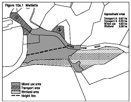
10a.18.6.2 Open
space
- A minimum of 35 per cent of the mixed
use area must be set aside and developed as open space (ie it must be
available for the public to access and use, and be free of buildings
except public amenities such as toilets, seating and playgrounds).
- At least 4000m2 of this
35 per cent must be located adjoining the esplanade reserve.
Explanation
This control is intended to ensure that there is sufficient
open space within and around the mixed use development for the public
to use and enjoy.
10a.18.6.3 Activities
abutting open space
Dwellings and visitor facilities must not comprise more
than 50 per cent (in aggregate) of the ground floor of buildings adjoining
areas identified as open space, as required by clause 10a.18.6.2 above.
Explanation
This control is intended to ensure that a significant
proportion of the activities fronting open space areas are active and
interesting and, consequently, add to the enjoyment of the open space
by the public.
10a.18.6.4 Threshold
controls
- The aggregate gross floor area (gfa)
of all threshold activities (ie those activities marked with an * in
the activity table at clause 10a.18.5.3) must not exceed 10,000m2
as a permitted activity and 12,000m2 as a discretionary activity.
- The aggregate gross floor area (gfa)
of all threshold activities (ie those activities marked with an * in
the activity table at clause 10a.18.5.3) must comply with the following:
- In addition to the above, dwellings,
visitor accommodation and tourist complexes must achieve a ratio of
4m2 gross floor area to 1m2 gross floor area of
retail premises and/or restaurants, cafés and other eating places
and/or all other activities.
Except that the control set out in (3) above does not
apply to the first 3000m2 of development or after 2000m2
of other activities has been established.
Notes:
- An activity not provided for in the activity
table (ie it is non-complying) must be considered to be a threshold
activity if it operates as a commercial activity (except for carparking).
- No portion of gross floor area can be
counted in two category limits.
- Where retail premises and restaurants,
cafes and other eating places are included within a tourist complex
they are subject to the sub-limit for retail premises, restaurants,
cafes and eating places (ie 1500m2) rather than the category
limit for tourist complexes (ie 7000m2).
Explanation
The threshold controls have two functions:
- To ensure that the overall amount of
threshold activities that can establish in the mixed use area will not
generate adverse effects in terms of the Matiatia landscape and transport
environment or with respect to water supply and wastewater disposal.
- To establish a 'gateway' to Waiheke
that includes a mix of uses rather than just one or two activities.
A mix of activities is considered beneficial because it will provide
activities for island residents (eg retail, offices and restaurant and
bar activities) and activities for visitors (eg visitor accommodation
and conference and events facilities). A mixed use development will
create a vibrant, safe and interesting built environment that is appropriate
at the 'gateway' to the Waiheke.
10a.18.6.5 Activity
size
Individual premises containing retail activity, a tavern
or restaurant, café or other eating place must not have a gross
floor area greater than 500m2.
Explanation
The 500m2 limit is intended to ensure a 'human
scale' of activities within the built environment at Matiatia.
10a.18.6.6 Minimum
dwelling size
The minimum gross floor area of dwellings is:
45m2 for one bedroom dwellings
70m2 for two bedroom dwellings
90m2 for three bedroom dwellings
Explanation
This control is to ensure that all dwellings at Matiatia
are of a size that will ensure that occupants enjoy a reasonable degree
of amenity and comfort.
10a.18.6.7 Internal
noise control for dwellings
- All dwellings must be designed and constructed
to provide an indoor design level of balanced noise criterion (NCB)
30 in any habitable room assuming the building is exposed to a noise
level of 55dBA Leq at the boundary of the site.
- The NCB level of 30 must be achieved
with windows and doors open unless adequate alternative ventilation
is provided to the requirements of clause G4 of the New Zealand Building
Code.
- Building elements (ie walls, floors)
which are common between different activities must be constructed to
prevent noise transmission to the requirements of clause G6 of the New
Zealand Building Code.
- After completion of the construction
of the dwelling(s), and before the issue of the code compliance certificate,
the consent holder must submit a report to the satisfaction of the council,
which is signed by a suitably qualified acoustic engineer, which certifies
that the dwelling(s) have been built in compliance with the noise and
ventilation requirements above.
Explanation
Residential development at Matiatia is to be designed
to ensure that an appropriate level of acoustic amenity is provided
within the bedrooms and other habitable rooms of residential activities,
taking into account other activities within the same development and
activity in the surrounding area.
10a.18.6.8 Noise
control between activities
The Leq noise levels and maximum level (Lmax),
arising from any activity, measured at or within the boundary of any
adjacent site (not held in common ownership) also within the Matiatia
land unit must not exceed:
Explanation
Excessive noise occurring for a continuous period or
duration can be damaging to public health and can have an adverse effect
on the amenity of the receiving environment.
10a.18.6.9 Parking
spaces required
Every owner or occupier who constructs, substantially
reconstructs or adds to any building or changes the use of any site
must provide on-site parking in accordance with following table:
Explanation
The above parking rules ensure that people can efficiently
access the activities located in the mixed use area and that there will
not be overspill of parking onto Ocean View Road. The above standards
take account of the public transport services available at Matiatia
and the fact that people using the mixed use development may also be
using the ferry services and consequently parked in parking areas for
ferry users.
Note: Rules for the provision of loading spaces and
the formation of parking and loading spaces are contained in Part 13
- Connectivity and linkages.
10a.18.6.10
Setback from mean high water springs
Carparking areas and carparking buildings (except those
for disabled users and short term and drop off spaces) must not be located
within 100m of MHWS.
Explanation
This control protects the landscape character and general
amenity of Matiatia Bay from the adverse effects of medium to large
at grade carparking areas and carparking buildings.
This control also avoids the adverse traffic congestion
and safety effects that would result from medium to large carparking
areas and buildings located in close proximity to the wharf area.
10a.18.6.11
Infrastructure servicing
- No activity that requires a wastewater
connection to the Owhanake wastewater treatment plant may be established
unless the wastewater generated by the activity, in combination with
the other activities in the mixed use area, will not exceed 80m3
per day or conditions 4 and 5 of the discharge permit have been satisfied.
- In addition to (1) above, no activity
may be established unless it is provided for in the water and wastewater
management plan. The water and wastewater management plan must be approved
by the council and the Auckland Regional Council and must contain all
of the following:
- An up to date record of all buildings
and the mix of activities within the mixed use area and the corresponding
peak design wastewater flow allocation, along with a total of the actual
flow generated from that mix of activities.
- Details of the current allocation
for the mixed use development from the Owhanake wastewater treatment
plant.
- Details of the contractual arrangements
for individual tenants and property developers/owners in respect of
water and wastewater management.
- Up to date monitoring of the water
use and wastewater discharge including (but not limited to: rainfall,
daily water storage, daily water use, daily treated effluent re-use
and an estimate of the occupancy and or patronage.
- Details of the water reduction fittings
and other water conservation measures that will be put in place.
- Details and procedures for the handling
of risks such as water shortages and contamination.
- Details of how water usage will
be monitored so that trends by activity can be established.
- In addition to (1) and (2) above,
no activity that is reliant on the re-use of treated wastewater from
the Owhanake wastewater treatment plant may be established unless approval
has been obtained from the medical officer of health and the operator
of the Owhanake wastewater treatment plant.
Explanation
Rule (1) above ensures that activities do not establish
in the mixed use area until there is capacity at the Owhanake wastewater
treatment plant to accommodate the wastewater generated by the activity
(in combination with all the other activities in the mixed use area).
The water and wastewater management plan is intended
to be a tool for the comprehensive management of the wastewater discharges
and water usage of activities in the mixed use area.
Rule (3) above ensures that activities reliant on the
re-use of treated wastewater do not establish unless confirmation has
been obtained that using such wastewater is acceptable from a heath
perspective and that re-use is acceptable with respect to the operation
and effectiveness of the Owhanake wastewater treatment plant.
10a.18.6.12
Water storage
Any new buildings must have access to bulk water supply
tanks in accordance with the following table:
Explanation
The water supply tanks are intended to ensure that the
activities within the mixed use area have an adequate and safe water
supply at all times of the year.
10a.18.7 Rules
- financial contributions
For all subdivision and development up to an aggregate
of 12,000m2 in the mixed use area, the following financial
contributions apply:
- The wetland area must be held in council
ownership and be available for passive recreation use by the public;
and
- The area marked on figure 10a.1a: Matiatia - financial contribution must be subject to a covenant which
ensures that no structure is placed or constructed in this area.
Development over 12,000m2 is subject to part
6 - Financial contributions.
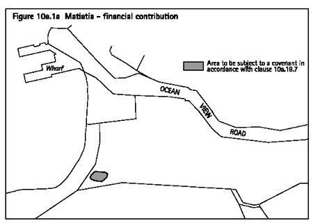
10a.18.8 Assessment
matters - for restricted discretionary activities
10a.18.8.1 Notification
requirements
Except as provided for by section 94C(2) of the RMA,
applications for a resource consent for the restricted discretionary
activities identified in the activity tables in clause 10a.18.5 will
be considered without public notification or the need to obtain written
approval of or serve notice on affected persons (in accordance with
section 94D(2) and (3) of the RMA).
10a.18.8.2 Buildings
in the mixed use area
- Matters of discretion
When considering an application to construct,
relocate, or carry out additions or alterations to a building in the
mixed use area, the council has restricted its discretion to considering
the following matters:
- scale
- form (including design and sustainable
design matters)
- materials
- location
- landscaping, open space and pedestrian
walkways
- residential amenity
- vehicle access and carparking.
- Assessment criteria
Discretion over the matters identified in clause
(1) above will be applied by considering the following:
- Building form and materials
The extent to which:
- The building(s) is designed to maintain
the landscape character and amenity of Matiatia.
- The building(s) is designed to
address and enhance the street, open spaces and other public areas,
particularly the waterfront.
- The building(s) is designed to
bear a strong relationship to the human scale.
- The scale, massing and height of
buildings is appropriate to the existing and nearby buildings, the topography
of the site and important views and vistas.
- Articulation and architectural detail
is used to keep areas of blank wall to a minimum and break up any excessive
bulk of the building(s).
- The rear of the building(s) and
service areas are orientated to the rear of other buildings.
- The public and private spaces
associated with each building are clearly distinguishable .
- Windows look directly onto the
street, open spaces and other public areas wherever possible.
- Entrances to upper floors are clearly
distinguished from entrances to lower floors.
- The building(s) is designed to accommodate
a wide range of uses, in particular the ceiling height on the ground
floor should be in the order of 3.5-4.0m to accommodate changes in activity
over time.
- The building(s) is constructed
of materials that are not highly reflective.
- External lighting has been used
to enhance public safety within the development without creating adverse
effects on surrounding sites.
- The building(s) incorporate verandahs
or other features which provide shelter for pedestrians.
- Building location
The extent to which:
- The building(s) achieves an integrated
and cohesive form of development, particularly when viewed by those
arriving on the ferry.
- The building(s) integrates the
mixed use development with public carparking and other transport infrastructure
in the area.
- The building(s) screen carparking
and other transport infrastructure so that it is not highly visible
to those arriving at Matiatia by boat.
- The building(s) create a sense
of definition and enclosure by fronting the edge of the street and open
spaces.
- Buildings containing 'active uses'
such as retail, restaurants, cafes and other eating places are located
in close proximity to the ferry terminal and carparking activities;
and buildings containing 'non-active uses' such as residential dwellings
are located further away from the ferry terminal and carparking activities.
- Landscaping, open space and pedestrian
walkways
- The extent to which landscaping will:
- Be put in place concurrently with the
proposed building(s).
- Be planted with ecosourced plants.
- Integrate the buildings with adjoining
open spaces and pedestrian walkways.
- Mitigate the adverse effects of the development
on the landscape character of Matiatia, particularly the coastal landscape.
- The extent to which open spaces:
- Will be put in place concurrently with
the proposed building(s).
- Will be planted with ecosourced plants.
- Will be located adjoining the esplanade
reserve and throughout the mixed use development so that variety of
open spaces are created, such as a large space for events and more intimate
spaces such as courtyards.
- Are designed to be safe, inviting and
attractive for the public and open at all times.
- Include public amenities such as shelter,
seating and lighting.
- The extent to which public walkways
will:
- Be put in place concurrently with the
proposed building(s).
- Create a clear and legible network throughout
the mixed use development and between the mixed use development and
the wharf and car parking areas.
- Be of a width and design that will facilitate
use by a variety of people, including commuters and visitors.
- Be lit and designed so as to be safe
for users during the day and night.
- Vehicle access and carparking required
for the mixed use development
- The extent to which vehicle access within
the mixed use area will:
- Create a clear and easy-to-follow network
of accessways for vehicles through the mixed use development.
- Be designed to be safely used by vehicles,
cyclists and pedestrians and includes traffic calming and paving differentiation
where appropriate.
- Be landscaped in a manner which integrates
the accessways with the mixed use development and the surrounding coastal
environment
- Minimise conflict with pedestrian flows.
- Include on-road and short term parking
where appropriate.
- The extent to which carparking
required for the mixed use development is:
- Designed and located in a manner which
maintains the visual amenity of the mixed use development and the Matiatia
landscape as a whole, particularly for those arriving at Matiatia.
- Integrated with the surrounding development
and other traffic infrastructure in terms of access points and traffic
flows, congestion and safety.
- Designed and located to facilitate sharing
of carparking spaces by activities eg night-time activities can use
the spaces unused by daytime activities.
- Designed and landscaped to provide a
safe environment for users during the day and the night.
- Residential dwellings
The extent to which a building(s) that is intended
to accommodate residential dwellings are:
- Designed to ensure that residents have
a high level of amenity, particularly in terms of private open space
and outlook.
- Located, designed and constructed
to ensure that residents have a high level of aural privacy and are
not unduly affected by noise from surrounding activities or by other
activities and services such as entrances and lift wells within the
building.
- Designed to ensure that there
is adequate admission of daylight.
- Sustainable design
The extent to which the building(s):
- Are designed to minimise energy consumption.
As a guide, buildings with a depth of 10-14m have good natural light
and can be naturally ventilated, thereby decreasing energy consumption.
- Are located, designed and orientated
to take account of solar access and other elements such as shelter from
the prevailing winds.
- Are designed to be 'water-autonomous',
particularly with respect to how the roof size and form maximises the
collection of rainwater and how water conservation devices and fittings
will be used.
- Are constructed of materials and
finishes that have been chosen because they are more sustainable than
others that might have been used, including consideration of embodied
energy, location of supply, life cycle assessment, toxicity and effects
on indoor air quality.
- Additional stormwater flows generated
by the building(s) will be managed within the development, by techniques
such as rain gardens, roof gardens and filtration strips.
Appendix 11 - Sustainable design guidelines for
the islands will assist applicants with these sustainable design criteria.
10a.18.8.3 Buildings
in transport area B
- Matters of discretion
When considering an application to construct,
relocate, or carry out additions or alterations to a building in transport
area B, the council has restricted its discretion to considering the
following matters:
- scale
- form (design)
- colour
- location
- vehicle access.
- Assessment criteria
Discretion over the matters identified in clause
(1) above will be applied by considering the extent to which the building:
- Is of a scale, form, colour and location
that is not visually prominent and will maintain the landscape character
of Matiatia, particularly when viewed by those arriving at Matiatia
by boat.
- Integrates with the mixed use development
on the adjoining site.
- Uses colour which integrates the
building with the surrounding landscape and buildings.
- Is constructed of materials which
are not highly reflective.
- Has vehicle access which has clear
site lines and avoids conflict with vehicles, cyclists and pedestrians.
10a.18.9 Assessment
matters - for discretionary activities
10a.18.9.1 Public
carparking and other transport infrastructure in the mixed use area
The council's assessment of an application for public
carparking and other transport infrastructure as a discretionary activity
in the mixed use area will include consideration of the relevant assessment
criteria for restricted discretionary activities and the extent to which
public carparking and other transport infrastructure:
- Has been located and designed to give
priority to passenger transport and other multiple occupancy vehicles.
- Has been designed and located so
that it is integrated with the mixed use development.
- Will have adverse effects on the
landscape character and visual amenity of Matiatia, particularly when
viewed by those arriving at Matiatia by boat.
- Will generate adverse effects in
terms of traffic safety and congestion on Ocean View Road.
- Will generate adverse effects on
the efficient operation of public transport and other multiple occupancy
vehicles.
- Will compromise the ability for
a mixed use development of 10,000m2 gross floor area to establish
in the mixed use area.
10a.18.9.2 Threshold
controls
The council's assessment of an application for a discretionary
activity to modify the threshold controls in clause 10a.18.6.4 will
include consideration of the extent to which the proposed gross floor
area and associated activities and / or buildings:
- Will contribute to providing a mix of
activities that will meet the needs of both residents and visitors using
Matiatia.
- Will compromise the ability for
a mixed use development that contains at least three types of threshold
activities to establish.
- Will create a vibrant, safe and
interesting gateway to Waiheke.
- Is able to be serviced in terms
of water supply and wastewater disposal (this should be assessed with
reference to the water and wastewater management plan).
- Will have adverse effects on the
parking and traffic environment at Matiatia, particularly in terms of
the safety and efficient functioning of the Matiatia transport system.
- Will result in a scale and intensity
of activity and built development that will have adverse effects on
the landscape character and visual amenity of Matiatia.
- Will result in adverse effects on
the overall functioning and viability of other commercial centres on
Waiheke such as Oneroa and Ostend. Consideration should be given to
the range of commercial services and facilities available in those centres
and any new activities that may occupy and sustain those centres in
the future.
- Is consistent with the council's
adopted growth strategies for Waiheke (if the proposal is for residential
activities).
10a.18.9.3 Other
listed discretionary activities
For other applications for resource consent refer to
part 11 - Assessment matters for assessment criteria for discretionary
activities.
10a.18.10 Relationship
with rules in other parts of the Plan
Part 14 - Definitions must be referred to as it is likely
to contain definitions of terms used in this part of the Plan.
The following parts of the Plan should also be referred
to as they may contain rules which apply to a particular site or proposal:
- Part 4 - General rules
- Part 5 - Network utility services
- Part 6 - Financial contributions
- Part 7 - Heritage
- Part 8 - Natural hazards
- Part 9 - Hazardous facilities and contaminated land
- Part 10c - Development controls for land units and settlement
areas
- Part 12 - Subdivision
- Part 13 - Connectivity and linkages
10a.19 Land unit
- Rural 1 (rural amenity)
10a.19.1 Introduction
This land unit is applied to pockets of small scale,
rural land located between the village areas of western Waiheke.
Rural amenity is characterised by:
- Small scale farming and horticulture activities.
- Flat to rolling land.
- A rural landscape with built elements
but also the openness, features and patterns created by productive activities.
- The contrast of its rural landscape with
the intensity and nature of the surrounding village development.
The area of the land unit adjoining Onetangi Road differs
from the other areas of rural amenity land in that it contains activities
that may be considered 'non-rural' in their character, such as wineries
and tourist complexes. The scale of this area of the land unit is sufficiently
large to accept these activities, while still maintaining a rural landscape
with an open pattern.
Overall, the land unit has high visual amenity value,
largely due to the contrast of its rural landscape with the village
style development that occurs throughout western Waiheke.
10a.19.2 Resource
management issues
The significant resource management issues that need
to be addressed in the Plan are:
- How to recognise the differences in scale
between the 'Onetangi Road' area of the land unit and the 'other areas'
of the land unit such as the Kennedy's Point, Palm Beach and Oneroa.
- How to protect the rural landscape
and visual amenity of the land unit from the adverse effects of buildings
and activities.
- How to protect the general amenity
of the land unit, particularly in the 'other areas'.
- How to provide for small scale rural
activities, such as farming and horticulture, to establish and operate
within the land unit.
- How to acknowledge that non-rural
activities such as restaurants, wineries and tourist complexes may be
appropriate and in fact beneficial in the right locations.
- How to control the size and nature
of non-rural activities so that the rural character and visual amenity
of the land unit is maintained.
Note: Refer to clause 10a.19.4 below for an explanation
of the 'Onetangi Road' and 'other areas' of the land unit.
10a.19.3 Objective
To provide for rural activities and a limited range
of non-rural activities while protecting the rural character and visual
amenity of the land unit.
Policies
- By providing for productive activities,
such as pastoral farming and horticulture to establish and operate within
the land unit.
- By limiting the non-productive activities
that can occur in the 'other areas' of the land unit to those which
avoid adverse effects on the rural character and on the general and
visual amenity of the locality.
- By ensuring that the non-productive
activities in the 'Onetangi Road' area will not have adverse effects
on the rural character and the general and visual amenity of the land
unit when viewed from Onetangi Road and surrounding locations.
- By ensuring that the scale, form,
colour and location of new buildings will not have adverse effects on
the visual amenity and rural character of the land unit.
- By requiring new sites to be of
a size and nature that ensures small scale rural activities can occur
and which maintains the rural character and visual amenity of the landscape.
10a.19.4 Resource
management strategy
As the Onetangi Road area of the land unit is different
in scale to the other areas of the land unit, the resource management
strategy is to divide the land unit into two parts; 'Onetangi Road'
and 'other areas'. The location of the Onetangi Road area is identified
on figure 10a.2.
In the 'other areas' the rural character and the general
amenity of the land unit is protected by limiting the range of non-productive
activities that can occur.
In the 'Onetangi Road' area of the land unit a wider
range of non-productive activities are provided for in recognition of
the fact that this area of the land unit is of a significantly larger
scale than the other areas and can therefore potentially accommodate
activities of a more intensive nature and larger scale. Notwithstanding,
an assessment of such activities is required to ensure that there are
no adverse effects on the rural character, visual amenity and general
amenity of the land unit.
An assessment of buildings is required in both the 'Onetangi
Road' and 'other areas' of the land unit to ensure that there are no
adverse effects on the rural character and the visual amenity of the
landscape.
10a.19.5 Rules
- activity table
Legend
P = Permitted
RD = Restricted discretionary
D = Discretionary
Notes:
- In this land unit, the activities of
constructing or relocating buildings, or undertaking exterior alterations
and additions to existing buildings, are to be treated as separate from
the activity of using buildings for any of the permitted activities
listed in the table. Therefore, even when an activity is permitted in
this table, a resource consent may still be required for any construction
or relocation of, or any exterior alteration or addition to, the building
used for the activity. The relationship between buildings and other
activities listed in activity tables is explained further in
clause
4.3.
- The activities of earthworks and
vegetation clearance are treated as development controls and are therefore
not listed in this table.
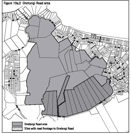
10a.19.6 Rules
- standards and terms for multiple dwellings
An application for multiple dwellings will only be considered
as a discretionary activity where one or more of the following criteria
are met:
- The resulting number of dwellings on
the site will be no more than that which would occur if the site were
subdivided in accordance with the rules in part 12 - Subdivision applying
to this land unit (with one dwelling per site).
- An application is made at the same
time for subdivision resulting in the amalgamation of sites such that
the number of dwellings on the new site created would be no greater
than that which could be achieved through locating a dwelling on each
of the original sites.
- The dwellings are for papakainga
housing.
- The land has been owned co-operatively
by a number of individuals since prior to 29 September 1992.
Proposals which do not meet these standards are a non-complying
activity.
10a.19.7 Rules
- development controls
The development controls listed below apply to all activities
whether or not those activities are otherwise permitted, restricted
discretionary, discretionary or non-complying. Infringements to these
development controls will be considered as development control modifications
as set out in clause 10c.3.
As well as the specific control set out below, there
are additional controls set out in part 10c - Development controls for
land units and settlement areas which also apply to this land unit.
10a.19.7.1 Onetangi
Road
On all sites with road frontage to Onetangi Road (as
identified on figure 10a.2), all new buildings or exterior additions
or alterations to an existing buildings must be located at least 100m
from the road boundary.
Explanation
The purpose of this particular rule is ensure that the
openness and rural character of the 'Onetangi Road' area of the land
unit is maintained.
10a.19.8 Assessment
matters
For applications for resource consent refer to part 11 - Assessment matters for:
- Matters of discretion and notification
requirements applying to the construction and relocation of buildings
and to exterior alterations and additions to existing buildings.
- Assessment criteria for discretionary
activities.
10a.19.9 Relationship
with rules in other parts of the Plan
Part 14 - Definitions must be referred to as it is likely
to contain definitions of terms used in this part of the Plan.
The following parts of the Plan should also be referred
to as they may contain rules which apply to a particular site or proposal:
- Part 4 - General rules
- Part 5 - Network utility services
- Part 6 - Financial contributions
- Part 7 - Heritage
- Part 8 - Natural hazards
- Part 9 - Hazardous facilities and contaminated land
- Part 10c - Development controls for land units and settlement
areas
- Part 12 - Subdivision
- Part 13 - Connectivity and linkages
10a.20 Land unit
- Rural 2 (western landscape)
10a.20.1 Introduction
This land unit applies to three distinct areas on Waiheke:
land at Owhanake, Church Bay and Park Point; land at Te Whau peninsula;
and land at Thompsons Point.
Western landscape is characterised by:
- Its coastal location in that all land
within the land unit either adjoins the coastline or is part of the
wider coastal environment.
- Large areas of environmental significance,
in particular wetland areas and areas of native vegetation.
- High natural character and visual amenity
due to the large areas of regenerating native bush, and the coastal
cliffs and slopes.
- A rural-residential style of living at
Owhanake, Church Bay, Park Point and Te Whau. Thompsons Point is currently
farmed.
- Small scale rural activities, primarily
with a horticulture focus.
- The landscape values of the land unit
are those of a cultural landscape containing four key elements:
- The openness and productivity of a rural
landscape.
- The natural character of a regenerating
landscape.
- The amenity of a low density residential
landscape.
- The visual prominence of a coastal
landscape.
Overall, western landscape provides for a rural-residential
style of living with high natural character and landscape values.
10a.20.2 Resource
management issues
The significant resource management issues which need
to be addressed in the Plan are:
- How to provide for small scale rural
activities to establish and operate within the land unit.
- How to protect the amenity of the
existing rural-residential activity located in the land unit.
- How to protect the natural character
and landscape values of the land unit, including the features and patterns
established by the small scale rural activities.
- How to provide for rural-residential
development to occur on Thompsons Point.
10a.20.3 Objective
To provide for and protect the rural-residential style
of living while avoiding the adverse effects of activities and buildings
on the natural character and landscape values of the land unit.
Policies
- By providing for rural and residential
activities to establish and operate in the land unit.
- By limiting the range of non-rural
and non-residential activities that can establish within the land unit
to avoid adverse effects on the landscape values and the general amenity
of the locality.
- By requiring new sites to be of
a size and nature that ensures that small scale rural activities can
occur and which protects the natural character and landscape values
of the land unit.
- By ensuring that the scale, form,
colour and location of new buildings will not have adverse effects on
the natural character and landscape values of the land unit.
- By providing for comprehensive development
to occur at Thompsons Point.
10a.20.4 Resource management strategy
As the land at Owhanake, Church Bay, Park Point and
Te Whau is largely developed to capacity, the focus of the resource
management strategy for these areas is to provide for the continued
operation of rural-residential activities and maintain the natural character
and landscape values of the land unit.
As Thompsons Point has not yet been developed to capacity,
comprehensive development is provided for in this area. Comprehensive
development will provide for a rural-residential style of living in
the context of a landscape enhanced by regenerating vegetation. Refer
to part 12 - Subdivision for the provisions relating to comprehensive
development at Thompsons Point. The location of Thompsons Point is identified
on figure 12.1 Thompsons Point.
The general amenity of the land unit is protected by
limiting the activities provided for to those of a residential or rural
nature and thereby avoiding activities that might generate significant
amounts of noise or traffic.
10a.20.5 Rules
- activity table
Legend
P = Permitted
RD = Restricted discretionary
D = Discretionary
Notes:
- In this land unit, the activities of
constructing or relocating buildings, or undertaking exterior alterations
and additions to existing buildings, are to be treated as separate from
the activity of using buildings for any of the permitted activities
listed in the table. Therefore, even when an activity is permitted in
this table, a resource consent may still be required for any construction
or relocation of, or any exterior alteration or addition to, the building
used for the activity. The relationship between buildings and other
activities listed in activity tables is explained further in
clause
4.3.
- The activities of earthworks and
vegetation clearance are treated as development controls and are therefore
not listed in this table.
10a.20.6 Rules
- development controls
Refer to part 10c - Development controls for land units
and settlement areas for the controls applying in this land unit. The
development controls listed in that part apply to all activities, whether
or not those activities are otherwise permitted, restricted discretionary,
discretionary or non-complying. Infringements to these development controls
will be considered as development control modifications as set out in
clause 10c.3.
10a.20.7 Assessment
matters
For applications for resource consent refer to part 11 - Assessment matters for:
- Matters of discretion and notification
requirements applying to the construction and relocation of buildings
and to exterior alterations and additions to existing buildings.
- Assessment criteria for discretionary
activities.
10a.20.8 Relationship
with rules in other parts of the Plan
Part 14 - Definitions must be referred to as it is likely
to contain definitions of terms used in this part of the Plan.
The following parts of the Plan should also be referred
to as they may contain rules which apply to a particular site or proposal:
- Part 4 - General rules
- Part 5 - Network utility services
- Part 6 - Financial contributions
- Part 7 - Heritage
- Part 8 - Natural hazards
- Part 9 - Hazardous facilities and contaminated land
- Part 10c - Development controls for land units and settlement
areas
- Part 12 - Subdivision
- Part 13 - Connectivity and linkages
10a.21 Land unit
- Rural 3 (Rakino amenity)
10a.21.1 Introduction
Rakino is a small island of approximately 146ha located
northeast of Motutapu. The island is 2.4km long and approximately 1.2km
wide.
Rakino is characterised by:
- Its location, small size and undulating
topography.
- The small permanent population (approximately
16) and high proportion of holiday homes, (there are approximately 76
dwellings in total on Rakino).
- Its two distinctive forms of residential
subdivision pattern are recognised by applying this rural 3 (Rakino
amenity area) land unit and the island residential 1 (traditional residential)
land unit.
- Its popular beaches and bays for recreational
boaties, residents and holiday homeowners.
- The location of the wharf and mooring
areas at Sandy Bay.
- A general private ownership pattern with
limited Department of Conservation and council ownership.
This land unit is characterised by:
- Sites of generally 4-5ha in size.
- Most of the sites have coastal frontage.
- Most of the coastline of Rakino being
within this land unit.
- Limited existing indigenous vegetation
with large portions of sites being grass covered, although coastal frontages
of sites generally contain remnants of indigenous vegetation, including
regenerating and mature pohutakawa.
- The high amenity, character and ecological
value of the coastline.
- Sites which generally contain dwellings
and operate as 'lifestyle blocks' with holidays homes or permanent dwellings,
although some are vacant.
- Undulating topography with a general downwards
slope towards the coastline.
Overall, the land unit has a unique coastal character
which has high amenity values.
10a.21.2 Resource
management issues
The significant resource management issues which need
to be addressed in the Plan are:
- How to provide for residential 'lifestyle'
activity on larger blocks of land on Rakino in a manner which protects
the character and coastal amenity of the island.
- How to ensure the protection of
existing indigenous vegetation and encourage the replanting of indigenous
vegetation on sites in order to enhance the ecological and visual amenity
values of the island and allow for effective stormwater and wastewater
disposal.
- How to acknowledge that certain
non-residential activities like small scale visitor accommodation may
be appropriate.
10a.21.3 Objectives
and policies
10a.21.3.1 Objective
To provide for residential buildings and small scale
visitor accommodation in a manner which protects the unique coastal
character and amenity of the land unit.
Policies
- By controlling the scale, form, colour
and location of new buildings to ensure that they are visually compatible
with, and do not dominate, the coastal environment.
- By restricting the type and size
of visitor accommodation within the land unit.
10a.21.3.2 Objective
To encourage the replanting of indigenous vegetation
on sites in order to enhance the ecological and visual amenity values
of the island and allow for effective wastewater disposal.
Policy
- By requiring the planting of sites for
amenity and wastewater disposal and ecological enhancement purposes.
10a.21.4 Resource
management strategy
The resource management strategy for the land unit is
to provide for predominantly residential uses and to manage the environmental
and visual impacts of such activities.
The coastal environment within Rakino is particularly
sensitive to the impact of development and this is recognised within
the land unit. The objectives and policies also recognise that revegetation
would improve the amenity and ecological value of the island.
10a.21.5 Rules
- activity table
Legend
P = Permitted
RD = Restricted discretionary
D = Discretionary
Notes:
- In this land unit, the activities of
constructing or relocating buildings, or undertaking exterior alterations
and additions to existing buildings, are to be treated as separate from
the activity of using buildings for any of the permitted activities
listed in the table. Therefore, even when an activity is permitted in
this table, a resource consent may still be required for any construction
or relocation of, or any exterior alteration or addition to, the building
used for the activity. The relationship between buildings and other
activities listed in activity tables is explained further in
clause
4.3.
- The activities of earthworks and
vegetation clearance are treated as development controls and are therefore
not listed in this table.
10a.21.6 Rules
- development controls
The development controls listed below apply to all activities
whether or not those activities are otherwise permitted, restricted
discretionary, discretionary or non-complying. Infringements to these
development controls will be considered as development control modifications
as set out in clause 10c.3.
As well as the specific controls set out below, there
are additional controls set out in part 10c - Development controls for
land units and settlement areas which also apply to this land unit.
10a.21.6.1 Planting
of front yards
On sites other than rear sites, not less than 60 per
cent of the 6m front yard must be planted with indigenous species (ecosourced
where practicable).
10a.21.6.2 Planting
of wastewater disposal areas
On all sites, planting of the wastewater disposal area
must be undertaken. Appendix 13 - Planting guide, identifies vegetation
that is appropriate for planting of effluent disposal fields.
10a.21.7 Assessment
matters
For applications for resource consent refer to part 11 - Assessment matters for:
- Matters of discretion and notification
requirements applying to the construction and relocation of buildings
and to exterior alterations and additions to existing buildings.
- Assessment criteria for discretionary
activities.
10a.21.8 Relationship
with rules in other parts of the Plan
Part 14 - Definitions must be referred to as it is likely
to contain definitions of terms used in this part of the Plan.
The following parts of the Plan should also be referred
to as they may contain rules which apply to a particular site or proposal:
- Part 4 - General rules
- Part 5 - Network utility services
- Part 6 - Financial contributions
- Part 7 - Heritage
- Part 8 - Natural hazards
- Part 9 - Hazardous facilities and contaminated land
- Part 10c - Development controls for land units and settlement
areas
- Part 12 - Subdivision
- Part 13 - Connectivity and linkages
10a.22 Land unit
- Recreation 1 (local parks and esplanade reserves)
10a.22.1 Introduction
This land unit is applied to the extensive network of
esplanade reserves, local parks and conservation reserves on Waiheke
and Great Barrier.
Local parks and esplanade reserves is characterised
by:
- Passive recreation activities such as
walking, cycling and picnic areas.
- A general absence of built development
aside from public amenity facilities such as signage, seating, playgrounds,
walkways, artworks and sculptures.
- High visual amenity value due to the open
space character and in the case of esplanade reserves the prominent
coastal location.
- High ecological values in parks and conservation
reserves that contain native bush, wetlands and other natural features.
Overall, the parks and reserves within the land unit
are a significant community asset with high visual amenity, passive
recreational and ecological values.
10a.22.2 Resource
management issues
The significant resource management issues which need
to be addressed in the Plan are:
- How to facilitate the use and enjoyment
of the land unit for passive recreation activities by the public.
- How to maintain and enhance the
ecological value of land unit, particularly in conservation reserves
and esplanade reserves.
- How to protect the visual amenity
and ecological value of the land unit from the adverse effects of new
buildings.
10a.22.3 Objective
To facilitate the use and enjoyment of local parks and
esplanade reserves for passive recreation while protecting the visual
amenity and ecological value of the land unit.
Policies
- By providing for passive recreation activities
to establish and operate within the land unit.
- By limiting the scale and intensity
of the activities that can occur within the land unit to avoid adverse
effects on the visual amenity and ecological value of the land unit.
- By ensuring that the scale, form,
colour and location of new buildings will not have adverse effects on
the visual amenity and ecological values of the land unit.
- By requiring that new planting on
conservation and esplanade reserves to consist of ecosourced species.
10a.22.4 Resource
management strategy
The resource management strategy is to meet the recreational
needs of the Waiheke and Great Barrier communities by providing for
passive recreation activities. The more intensive recreational activities,
such as sports fields, are not provided for in order to avoid adverse
effects on the ecological and visual amenity value of the land unit.
An assessment of new buildings is required to ensure
that there will not be adverse effects on the ecological and visual
amenity value of the land unit.
10a.22.5 Rules
- activity table
Legend
P = Permitted
RD = Restricted discretionary
D = Discretionary
Notes:
- In this land unit, the activities of
constructing or relocating buildings, or undertaking exterior alterations
and additions to existing buildings, are to be treated as separate from
the activity of using buildings for any of the permitted activities
listed in the table. Therefore, even when an activity is permitted in
this table, a resource consent may still be required for any construction
or relocation of, or any exterior alteration or addition to, the building
used for the activity. The relationship between buildings and other
activities listed in activity tables is explained further in
clause
4.3.
- The activities of earthworks and
vegetation clearance are treated as development controls and are therefore
not listed in this table.
10a.22.6 Rules
- development controls
The development controls listed below apply to all activities
whether or not those activities are otherwise permitted, restricted
discretionary, discretionary or non-complying. Infringements to these
development controls will be considered as development control modifications
as set out in clause 10c.3.
As well as the specific controls set out below, there
are additional controls set out in part 10c - Development controls for
land units and settlement areas which also apply to this land unit.
10a.22.6.1 Ecosourced
planting
In conservation reserves and esplanade reserves only,
all planting must consist of ecosourced species.
Explanation
The purpose of this particular rule is to protect and
enhance the ecological value of the conservation and esplanade reserves
within the land unit.
10a.22.7 Assessment
matters
For applications for resource consent refer to part 11 - Assessment matters for:
- Matters of discretion and notification
requirements applying to the construction and relocation of buildings
and to exterior alterations and additions to existing buildings.
- Assessment criteria for discretionary
activities.
10a.22.8 Relationship
with rules in other parts of the Plan
Part 14 - Definitions must be referred to as it is likely
to contain definitions of terms used in this part of the Plan.
The following parts of the Plan should also be referred
to as they may contain rules which apply to a particular site or proposal:
- Part 4 - General rules
- Part 5 - Network utility services
- Part 6 - Financial contributions
- Part 7 - Heritage
- Part 8 - Natural hazards
- Part 9 - Hazardous facilities and contaminated land
- Part 10c - Development controls for land units and settlement
areas
- Part 12 - Subdivision
- Part 13 - Connectivity and linkages
10a.23 Land unit
- Recreation 2 (community facilities and sports parks)
10a.23.1 Introduction
This land unit is applied to sports parks and community
facilities such as halls, Marae and clubrooms on Rakino, Waiheke and
Great Barrier.
Community facilities and sports parks is characterised
by:
- A range of active recreation (eg sports
fields, skateboard parks) and community activities (eg community meetings).
- A variety of buildings such as halls,
changing rooms, clubrooms and sports equipment.
Overall, the community facilities and sports parks within
the land unit play an important role in providing for the recreational
and social needs of the Rakino, Waiheke and Great Barrier communities.
10a.23.2 Resource
management issues
The significant resource management issues which need
to be addressed in the Plan are:
- How to facilitate the use and enjoyment
of community facilities and sports parks for active recreation and community
activities.
- How to protect the visual amenity
of the land unit from the adverse effects of new buildings.
10a.23.3 Objective
To facilitate the use and enjoyment of community facilities
and sports parks for active recreation and community activities while
protecting the visual amenity of the land unit.
Policies
- By providing for active recreation and
community activities to establish and operate in the land unit.
- By ensuring that the scale, form,
colour and location of new buildings will not have adverse effects on
the visual amenity of the land unit.
10a.23.4 Resource
management strategy
The resource management strategy is to provide for active
recreation and community purposes so that these activities can continue
to contribute to the recreational and social needs of the Rakino, Waiheke
and Great Barrier communities.
An assessment of new buildings is required to ensure
that they will not have adverse effects on the visual amenity of the
land unit.
10a.23.5 Rules
- activity table
Legend
P = Permitted
RD = Restricted discretionary
D = Discretionary
Notes:
- In this land unit, the activities of
constructing or relocating buildings, or undertaking exterior alterations
and additions to existing buildings, are to be treated as separate from
the activity of using buildings for any of the permitted activities
listed in the table. Therefore, even when an activity is permitted in
this table, a resource consent may still be required for any construction
or relocation of, or any exterior alteration or addition to, the building
used for the activity. The relationship between buildings and other
activities listed in activity tables is explained further in
clause
4.3.
- The activities of earthworks and
vegetation clearance are treated as development controls and are therefore
not listed in this table.
10a.23.6 Rules
- development controls
Refer to part 10c - Development controls for land units
and settlement areas for the controls applying in this land unit. The
development controls listed in that part apply to all activities, whether
or not those activities are otherwise permitted, restricted discretionary,
discretionary or non-complying. Infringements to these development controls
will be considered as development control modifications as set out in
clause 10c.3.
10a.23.7 Assessment
matters
For applications for resource consent refer to part 11 - Assessment matters for:
- Matters of discretion and notification
requirements applying to the construction and relocation of buildings
and to exterior alterations and additions to existing buildings.
- Assessment criteria for discretionary
activities.
10a.23.8 Relationship
with rules in other parts of the Plan
Part 14 - Definitions must be referred to as it is likely
to contain definitions of terms used in this part of the Plan.
The following parts of the Plan should also be referred
to as they may contain rules which apply to a particular site or proposal:
- Part 4 - General rules
- Part 5 - Network utility services
- Part 6 - Financial contributions
- Part 7 - Heritage
- Part 8 - Natural hazards
- Part 9 - Hazardous facilities and contaminated land
- Part 10c - Development controls for land units and settlement
areas
- Part 12 - Subdivision
- Part 13 - Connectivity and linkages
10a.24 Land unit
- Recreation 3 (Rangihoua Park)
10a.24.1 Introduction
Rangihoua Park is a 110ha reserve which is owned by
council. It is a significant part of council's open space strategy for
Waiheke. Rangihoua Park currently contains the following activities:
- a golf course
- playing fields and associated buildings
- tennis courts
- picnic and BBQ area
- walking tracks and bridle trails
- a historic village and museum
- a lawn cemetery
- an equestrian area
- parking and vehicle access areas.
Included within the park are three streams, some wetland
areas, two ponds and areas of planting. The main landscape feature is
Rangihoua Maunga which is a single cone volcano. The park is located
adjacent to the Rangihoua Creek and Putiki Bay estuary which is of ecological
significance.
The land occupied by the park is of significance to
iwi. The area was occupied by the ancestors of Ngati Paoa and the Putiki-O-Kahu
Pa was located on the Rangihoua Maunga. The slopes of Rangihoua were
cultivated for many generations and the terraces can still be seen.
The Rangihoua area is waahi tapu, of spiritual significance to the tangata
whenua.
The park contains the following heritage items which
are scheduled elsewhere in the Plan:
- an archaeological site on Rangihoua Maunga
- a building in the historic village.
10a.24.2 Resource
management issues
The significant resource management issues which need
to be addressed in the Plan are:
- How to manage the use of the park in
an integrated manner which recognises the differing characteristics
and differing scales and types of land use appropriate to various parts
of the park.
- How to manage the relationship between
the park and surrounding land uses and water bodies (Rangihoua Creek
and Putiki Bay) in order to avoid adverse effects and achieve positive
benefits throughout Rangihoua Park.
- How to recognise and protect the
significant iwi values associated with the Rangihoua Maunga.
- How to maintain and enhance the
landscape and ecological values associated with the Rangihoua Maunga,
the open space character of the park, the streams and pond, and the
vegetated areas.
- How to manage the range of community
aspirations to use the park in a variety of ways including for active
and passive recreation and for cultural activities.
10a.24.3 Objectives
and policies
10a.24.3.1 Objective
To recognise and protect the significant iwi values
associated with the Rangihoua Maunga.
Policies
- By involving iwi in the management of
the Rangihoua Maunga.
- By not providing for any activities,
other than planting and maintenance of ecosourced species on the Rangihoua
Maunga.
Explanation
The council has set up a Kaitiaki Management Committee
to manage the Rangihoua Maunga. The committee includes iwi and council
representatives.
Note: The council has agreed to an approach with tangata
whenua that limits access to Rangihoua Maunga to iwi approved people.
10a.24.3.2 Objective
To maintain and enhance the landscape values and open
space character of the park associated with the Rangihoua Maunga, the
bush, and the streams and wetland areas.
Policies
- By controlling the scale, form, colour
and location of buildings within the park to ensure that the dominance
of the natural environment is retained.
- By recognising and protecting Rangihoua
Maunga as the dominant landscape feature of the park.
- By protecting the stream and bush
areas from development.
Explanation
Rangihoua Park has considerable landscape values. It
is important that any buildings that may be located within the recreation,
cultural and heritage facilities and landscape amenity areas need to
be sympathetic to the surrounding landscape.
10a.24.3.3 Objective
To maintain and enhance the ecological values associated
with the vegetation, streams, wetland areas, and the adjacent Rangihoua
Creek and Putiki Bay.
Policies
- By requiring any planting to consist
of ecosourced species.
- By requiring planting along the
stream banks within the park.
- By controlling earthworks and vegetation
clearance in order to limit sediment runoff into on-site streams and
into Rangihoua Creek and Putiki Bay.
Explanation
Rangihoua Park has considerable ecological values. It
is important that these are recognised and provided for by any future
development of the park.
10a.24.3.4 Objective
To provide for a range of types of community use as
appropriate throughout the different parts of the park.
Policies
- By providing for and directing recreation
and associated facilities in those parts of the park identified as most
suitable for this purpose.
- By providing for buildings and structures
which will contribute to the community use of the park, at an appropriate
scale and in appropriate locations.
- By providing for the ongoing use
and limited expansion of the lawn cemetery, and the historic village
and museum.
10a.24.3.5 Objective
To provide for appropriate levels of public access to
the park.
Policies
- By providing for public access at appropriate
locations.
- By recognising the importance of
linking walkways and bridle trails in the park with the wider network
of walkways and trails.
10a.24.3.6 Objective
To ensure that buildings and activities on the park
do not adversely affect adjacent sites.
Policies
- By setting appropriate noise standards
for activities on the park.
- By controlling the location of buildings
with respect to adjacent sites.
- By requiring parking areas to be
set back from the park's external boundaries.
10a.24.4 Resource
management strategy
The resource management strategy is to divide the park
into the following five areas:
- recreation
- conservation
- Rangihoua Maunga
- cultural and heritage facilities
- landscape amenity.
These areas are identified on figure 10a.3 Rangihoua
Park.
These areas recognise that different planning approaches
are required for the various areas of the park. The characteristics
of these areas are further described below.
- Area A - recreation
This area includes the following:
- sports fields
- tennis courts
- golf course
- equestrian area
- associated buildings.
The planning approach for this area focuses on
providing for recreation.
- Area B - conservation
This area includes the three tributaries of Rangihoua
Creek which flow through the park. The planning approach for this area
focuses on protecting and enhancing the streams, including their banks.
- Area C - Rangihoua Maunga
The planning approach for this area focuses on
protecting the upper slopes of the Rangihoua Maunga to recognise and
provide for its iwi values and also its dominance as a landscape feature
within the park.
- Area D - cultural and heritage facilities
This area includes the lawn cemetery, and the
historic village and museum. The planning approach for this area focuses
on providing for the continued operation and limited expansion of these
facilities.
- Area E - landscape amenity
This area is characterised by large areas of open
space, bush and revegetated areas. It includes the lower slopes of the
Rangihoua Maunga. The planning approach for this area focuses on maintaining
the landscape amenity and providing for specific recreation opportunities,
such as walking tracks and bridle trails.
10a.24.5 Rules
- activity table
Legend
Areas:
A - Recreation
B - Conservation
C - Rangihoua Maunga
D - Cultural and heritage facilities
E - Landscape amenity
P = Permitted
RD = Restricted discretionary
D = Discretionary
NC = Non-complying
n/a applies where it is not possible to undertake
the activity within the defined area.
Notes:
- In this land unit the activities of constructing
or relocating buildings, or undertaking exterior alterations and additions
to existing buildings, are to be treated as separate from the activity
of using buildings for any of the permitted activities listed in the
table. Therefore, even when an activity is permitted in this table,
a resource consent may still be required for any construction or relocation
of, or any exterior alteration or addition to, the building used for
the activity. The relationship between buildings and other activities
listed in activity tables is explained further in clause
4.3.
- The Kaitiaki Management Committee,
which includes tangata whenua representatives, has been set up to manage
the Rangihoua Maunga. All activities within area C - Rangihoua Maunga
require the approval of the tangata whenua through the Kaitiaki Management
Committee. This includes earthworks, vegetation removal and planting.
- The activities of earthworks and
vegetation clearance are treated as development controls and are therefore
not listed in this table.
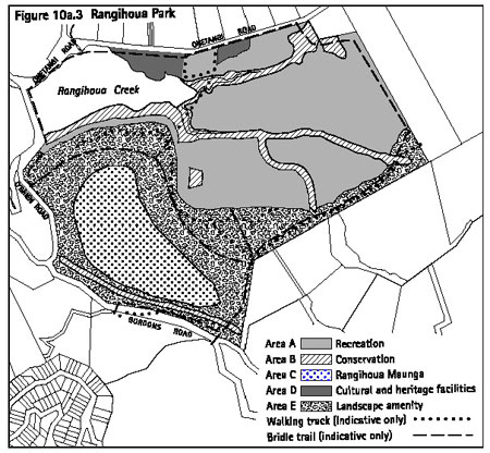
10a.24.6 Rules
- development controls
Refer to part 10c - Development controls for land units
and settlement areas for the controls applying in this land unit. The
development controls listed in that part apply to all activities whether
or not those activities are otherwise permitted, restricted discretionary,
discretionary or non-complying. Infringements to these development controls
will be considered as development control modifications as set out in
clause 10c.3.
10a.24.7 Assessment
matters - restricted discretionary activities
10a.24.7.1 Buildings
in areas A, D and E
Refer to part 11 - Assessment matters for matters of
discretion and notification requirements relating to applications for
the construction and relocation of buildings and for exterior alteration
and additions to existing buildings.
10a.24.7.2 Planting
and maintenance of ecosourced species in area C
Matters of discretion
When considering an application for planting and maintenance
of ecosourced species in area C (Rangihoua Maunga) the council has restricted
its discretion to considering the following matters:
- The extent to which the planting adversely
affects the visual, cultural and spiritual values of significance to
tangata whenua.
- Any consultation undertaken with tangata
whenua.
Notification requirements
Except as provided for by section 94C(2) of the RMA,
such applications for a resource consent will be considered without
public notification or the need to obtain written approval of or serve
notice on affected persons, other than tangata whenua (in accordance
with section 94D(2) and (3) of the RMA).
10a.24.8 Assessment
matters - discretionary activities
10a.24.8.1 Artificial
lighting and community facilities
For applications for artificial lighting or community
facilities as a discretionary activity, refer to part 11 - Assessment
matters for assessment criteria.
10a.24.8.2 Other
discretionary activities
The council's assessment of any other discretionary
activity listed in clause 10a.24.5 will include consideration of the
following matters:
- Noise
Whether the activity gives rise to adverse noise
effects experienced beyond the boundaries of the park.
- Intensity
Whether the intensity and scale of the activity,
in particular, the number of people involved, traffic generation, size
and location of buildings and associated parking will be compatible
with the character and amenity values of park.
- Activities
- The extent to which any activity is consistent
with any relevant open space strategy or reserve management plan.
- Whether the activity is consistent
with the intent of the relevant objectives, policies and planning approach
for the area.
- Tangata whenua
The extent to which the activity adversely affects
the visual, cultural and spiritual values of significance to tangata
whenua. This will include consideration of any consultation undertaken
with tangata whenua.
- Crime prevention through environmental
design
- The extent to which the activity provides
or continues to provide for informal surveillance of public areas.
- The extent to which informal surveillance
and clear visibility and clear lines of sight has been achieved through
the location and design of any building, landscaping, fencing and other
structures.
- Whether the proposed activity provides
appropriate lighting of public and semi-public areas, including paths,
parking areas, building entrances and exits.
- Landscaping
Whether any proposed landscaping uses ecosourced
species.
- Natural environment
- The extent to which the activity gives
rise to adverse effects on the natural environment, eg from vegetation
removal, earthworks and the generation of wastewater (including stormwater).
- The effects of the proposed activity
on the ecological values for the area.
10a.24.9 Relationship
with rules in other parts of the Plan
Part 14 - Definitions must be referred to as it is likely
to contain definitions of terms used in this part of the Plan.
The following parts of the Plan should also be referred
to as they may contain rules which apply to a particular site or proposal:
- Part 4 - General rules
- Part 5 - Network utility services
- Part 6 - Financial contributions
- Part 7 - Heritage
- Part 8 - Natural hazards
- Part 9 - Hazardous facilities and contaminated land
- Part 10c - Development controls for land units and settlement
areas
- Part 12 - Subdivision
- Part 13 - Connectivity and linkages
10a.25 Land unit
- Conservation
10a.25.1 Introduction
This land unit covers a number of smaller islands, both
publicly and privately owned, and land owned by the Department of Conservation
(DOC) on Great Barrier, Waiheke and Rakino. Some of the larger islands
and island groups include Rangitoto, Motutapu, Motuihe, Browns Island,
Kaikoura, Little Barrier, the Noises, the Mokohinau Islands and the
Three Sisters group.
The characteristics of the land unit are:
- High scenic and ecological conservation
values.
- The land is mostly managed by DOC under
the Conservation Act 1987 and the Auckland Conservation Management Strategy.
- Small islands, regenerating or natural
forest areas, with small parts of the land unit used for farming activities.
Conservation management is a key function of the land
unit, and it also has an education and recreational role on a regional
and national level. Because a large portion of the land is DOC owned,
and because of the special value of the land in a regional and national
sense, it has been identified as needing specific rules in the Plan
to enable appropriate conservation, education and recreation activities
to occur.
The council acknowledges that section 4(3) of the RMA
exempts the crown from complying with a rules in the Plan in certain
instances by stating that:
'Section 9(1) does not apply to any work or activity
of the Crown within the boundaries of any area of land held or managed
under the Conservation Act 1987 or any other Act specified in Schedule
1 to that Act (other than land held for administrative purposes) that
-
- Is consistent with a conservation management
strategy, conservation management plan, or management plan established
under the Conservation Act 1987 or any other Act specified in Schedule
1 to that Act; and
- Does not have a significant adverse
effect beyond the boundary of the area of land.'
10a.25.2 Resource
management issues
The significant resource management issues which need
to be addressed in the Plan are:
- How to conserve, protect and enhance
the natural environment of islands with high conservation values.
- How to manage potential tourism
and recreation impacts on this land unit.
- How to have special regard to the
environmental values of these islands, and particularly those related
to flora and fauna and to manage land use activities and development
accordingly.
- How to provide for limited facilities
and infrastructure in order to minimise or avoid any detrimental impacts
arising from education, visitor and recreational activities.
10a.25.3 Objective
To ensure that the land unit is appropriately managed
to enable conservation, preservation and enhancement of the natural
environment along with appropriate educational, visitor and recreational
activities
Policies
- By enabling conservation activities and
the establishment of walking tracks by DOC to be undertaken as permitted
activities.
- By limiting adverse visual effects
of buildings by controlling the scale, form, colour and location of
new buildings to ensure that the natural landscape remains the dominant
element.
- By ensuring that any potential impacts
arising from educational, visitor and recreational activities around
the islands do not detrimentally impact upon or affect the natural and
environmental values of the islands.
- By protecting flora and fauna indigenous
to the islands through strict controls on vegetation removal.
- By recognising the need to protect
the conservation values of privately owned islands in the land unit
and limiting the range of activities that can occur on these.
10a.25.4 Resource
management strategy
The resource management strategy for the land unit is
to focus on the value of conservation and protection of valuable publicly
owned land, and some privately owned islands, to enable conservation
and recreation activities. DOC activities need to be able to be undertaken
with minimal council involvement, except where these may have significant
adverse effects on the environment.
10a.25.5 Rules
- activity table
Legend
P = Permitted
RD = Restricted discretionary
D = Discretionary
Notes:
- In this land unit, the activities of
constructing or relocating buildings, or undertaking exterior alterations
and additions to existing buildings, are to be treated as separate from
the activity of using buildings for any of the permitted activities
listed in the table. Therefore, even when an activity is permitted in
this table, a resource consent may still be required for any construction
or relocation of, or any exterior alteration or addition to, the building
used for the activity. The relationship between buildings and other
activities listed in activity tables is explained further in
clause
4.3.
- The activities of earthworks and
vegetation clearance are treated as development controls and are therefore
not listed in this table.
10a.25.6 Rules
- development controls
The development controls listed below apply to all activities
whether or not those activities are otherwise permitted, restricted
discretionary, discretionary or non-complying. Infringements to these
development controls will be considered as development control modifications
as set out in clause 10c.3.
As well as the specific controls set out below, there
are additional controls set out in part 10c - Development controls for
land units and settlement areas which also apply to this land unit.
10a.25.6.1 Earthworks
and vegetation clearance associated with track and hut construction
on land owned or managed by DOC
The following permitted activities are not required
to comply with the standards in part 10c - Development controls for
land units and settlement areas, relating to earthworks and indigenous
vegetation clearance:
- Any earthworks or removal of indigenous
vegetation associated with construction of walking tracks and undertaken
by DOC or DOC approved contractors.
- Any earthworks or removal of indigenous
vegetation required for DOC hut construction and undertaken by DOC or
DOC approved contractors.
All earthworks described above must be undertaken using
erosion and sediment control measures to ensure that, in so far as practicable,
soil erosion is minimised and sediment does not enter into wetlands
or water bodies. For information on how to achieve this refer to
appendix
16 - Erosion and sediment control guidelines for earthworks.
10a.25.7 Assessment
matters
For applications for resource consent refer to part 11 - Assessment matters for:
- Matters of discretion and notification
requirements applying to the construction and relocation of buildings
and to exterior alterations and additions to existing buildings.
- Assessment criteria for discretionary
activities.
10a.25.8 Relationship
with rules in other parts of the Plan
Part 14 - Definitions must be referred to as it is likely
to contain definitions of terms used in this part of the Plan.
The following parts of the Plan should also be referred
to as they may contain rules which apply to a particular site or proposal:
- Part 4 - General rules
- Part 5 - Network utility services
- Part 6 - Financial contributions
- Part 7 - Heritage
- Part 8 - Natural hazards
- Part 9 - Hazardous facilities and contaminated land
- Part 10c - Development controls for land units and settlement
areas
- Part 12 - Subdivision
- Part 13 - Connectivity and linkages
10a.26 Land unit
- Pakatoa
10a.26.1 Introduction
This land unit is specific to Pakatoa Island, a small
24ha island which lies off the eastern end of Waiheke. It is the northern
most of a chain of islands that extends from Man O' War Bay down to
the Clevedon Coast.
The island is characterised by:
- Relatively intense land use confined to
the northern half of the island.
- An historical use as a tourist complex.
- Development consisting of small scale
distinct visitor units, with a main hotel area.
- Sandy white beaches with a low coastal
escarpment.
- Open space, pohutukawa forest, and remnant
bush in the south of the island.
- The only population of weka in the inner
islands.
Overall, the island provides for a mix of uses that
support the potential for a small residential community combined with
a tourist complex activity, while recognising limits to the physical
and visual carrying capacity for a small island and the sensitive nature
of the coastal environment.
The Pakatoa land unit has been divided into three sub-areas
as follows:
- tourist complex area
- residential area
- landscape protection area.
The location of each area is identified on figure 10a.4:
Pakatoa.
10a.26.2 Resource
management issues
The significant resource management issues which need
to be addressed in the Plan are:
- How to conserve and where appropriate
restore the natural character of the island and, in particular, its
coastline.
- How to achieve a balance between
open space and buildings to preserve the visual character of the land
unit as seen from the sea and eastern Waiheke when identifying appropriate
future uses.
- How to enable continued use of the
island for visitor and residential purposes, while limiting the visual
impact of buildings and other structures when seen from the sea and
other islands in proximity to Pakatoa and maintaining landscape values.
- How to enable opportunities for
public access to the island and recreational opportunities on the island.
- How to protect wildlife habitats
and indigenous flora and fauna.
10a.26.3 Objectives
and policies
10a.26.3.1 Objective
- tourist complex area
To provide for a high quality environment accommodating
a mix of visitor related activities (including public open space) that
is consistent with existing development in this area.
Policies
- By controlling the scale, form, colour
and location of new buildings or modification of existing buildings
in order to maintain or enhance visual amenity and character.
- By providing for a range of activities
that support the visitor and residential activities located on the island.
- By requiring landscape planting,
including revegetation as part of any development proposal where this
will enhance landscape and environmental qualities and is necessary
to reduce the visual impact of buildings and land use activities.
10a.26.3.2 Objective
- residential area
To provide for limited residential and visitor activities
that integrate with the island’s landscape setting.
Policies
- By controlling the scale, form, colour
and location of new buildings or modification or additions to existing
buildings in order to maintain or enhance visual amenity and character.
- By enabling the clustering of buildings
at specified densities at the northern end of the island, or the dispersal
of buildings at lower densities across the island, as a means of reducing
impact on the small island character.
10a.26.3.3 Objective
- landscape protection area
To preserve the coastal margins and open rural landscape
character of the island.
Policies
- By protecting open space and natural
areas on the island by restricting buildings, indigenous vegetation
removal and earthworks in these areas.
- By requiring pest and weed management
in the landscape protection area as part of any subdivision application
for the island.
10a.26.4 Resource
management strategy
The resource management strategy for Pakatoa is to provide
for the continued use and development of the island for visitor and
residential activities within a management framework which recognises
the need to protect the visual character and amenity of the island.
The strategy is to use specific rules that manage the density, location,
design and appearance of buildings. Land use activities relate to those
needed to support residential or visitor activities.
The strategy recognises that the existing scale and
intensity of development is quite high. The strategy recognises this
existing use by continuing to provide for a similar scale and intensity
of activity. Pakatoa is managed through the use of an area plan which
set out areas where different development or protection controls apply.
As noted above, these areas are:
- tourist complex area
- residential area
- landscape protection area.
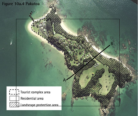
10a.26.5 Rules
- activity table
Legend
P = Permitted
RD = Restricted discretionary
D = Discretionary
NC = Non-complying
Notes:
- In this land unit, the activities of
constructing or relocating buildings, or undertaking exterior alterations
and additions to existing buildings, are to be treated as separate from
the activity of using buildings for any of the permitted activities
listed in the table. Therefore, even when an activity is permitted in
this table, a resource consent may still be required for any construction
or relocation of, or any exterior alteration or addition to, the building
used for the activity. The relationship between buildings and other
activities listed in activity tables is explained further in
clause
4.3.
- The activities of earthworks and
vegetation clearance are treated as development controls and are therefore
not listed in this table.
10a.26.6 Rules
- development controls
The development controls listed below apply to all activities
whether or not those activities are otherwise permitted, restricted
discretionary, discretionary or non-complying. Infringements to these
development controls will be considered as development control modifications
as set out in clause 10c.3.
As well as the specific controls set out below, there
are additional controls set out in part 10c - Development controls for
land units and settlement areas which also apply to this land unit.
10a.26.6.1 Maximum
number of dwellings or visitor accommodation units
- The maximum number of dwellings and/or
visitor accommodation units permitted on Pakatoa is 50 in total.
- Of the 50 dwellings and/or visitor
accommodation units provided for in (1) above, the maximum number that
can be located in the residential area of the land unit is either:
- 30 - where the dwellings and/or visitor
accommodation units are clustered to the northwest of line AB (refer
figure 10a.4: Pakatoa); or
- 15 - where the dwellings and/or
visitor accommodation units are located in a dispersed pattern across
the entire residential area.
10a.26.7 Assessment
matters
For applications for resource consent refer to part 11 - Assessment matters for:
- Matters of discretion and notification
requirements applying to the construction and relocation of buildings
and to exterior alterations and additions to existing buildings.
- Assessment criteria for discretionary
activities.
10a.26.8 Relationship
with rules in other parts of the Plan
Part 14 - Definitions must be referred to as it is likely
to contain definitions of terms used in this part of the Plan.
The following parts of the Plan should also be referred
to as they may contain rules which apply to a particular site or proposal:
- Part 4 - General rules
- Part 5 - Network utility services
- Part 6 - Financial contributions
- Part 7 - Heritage
- Part 8 - Natural hazards
- Part 9 - Hazardous facilities and contaminated land
- Part 10c - Development controls for land units and settlement areas
- Part 12 - Subdivision
- Part 13 - Connectivity and linkages
10a.27 Land unit
- Rotoroa
10a.27.1 Introduction
Rotoroa is a relatively small (82.5ha) island located
to the east of Waiheke between Pakatoa and Ponui. At its narrowest point,
the island is 170m in width but it is over 2km long, dimensioned north
to south.
Rotoroa is characterised by:
- A landscape with high visual amenity value
because of the series of small bays, headlands, ridgelines, knolls and
hill-slopes and pockets of pohutukawa on the coastal fringe.
- A variety of buildings congregated behind
the main beach at Home Bay.
- Scattered dwellings around the northern
portion of the island.
- Pockets of exotic forestry woodlots, which
serve to screen the majority of built development when viewed from the
sea.
- Heritage items including the Tea House,
detention cells, the hulk of the SS Rimu, stands of phoenix palms and
Norfolk Island pine.
- Archaeological and geological sites including
middens, pa and coastal stacks.
Rotoroa was used as a rehabilitation centre for people
suffering from addiction problems until 2005. Now that the rehabilitation
centre has closed, it is intended that the majority of existing buildings
will be removed and the island redeveloped, primarily for conservation
purposes but also for residential and visitor activities.
10a.27.2 Resource
management issues
The significant resource management issues which need
to be addressed in the Plan are:
- How to provide for conservation activities
so that the natural character value of the island is enhanced.
- How to provide for visitor and residential
activities while protecting the landscape character and natural features
of the island from the adverse effects of activities and buildings.
- How to provide for public access
around the island, particularly adjoining the coast.
10a.27.3 Objective
To provide for residential, conservation and visitor
activities to occur while ensuring that the landscape character and
natural features of the island are protected and enhanced.
Policies
- By providing areas throughout the island
for public access and recreation activities.
- By ensuring that the scale, form,
colour and location of residential buildings will not have an adverse
effect on the natural character and heritage features or landscape character
of the island.
- By requiring revegetation to be
undertaken concurrently with the construction of residential buildings
so that the adverse effects of those buildings are mitigated and the
natural character of the island enhanced.
- By requiring buildings and activities
for visitors to be planned and developed in a comprehensive and integrated
manner so that the landscape character of the island is protected.
- By ensuring that the nature and
intensity of visitor activities will not detract from the amenity or
character or natural features of the island.
10a.27.4 Resource
management strategy
The resource management strategy for Rotoroa is to divide
the land unit into two different areas. This approach recognises that
each of these areas will be used and developed in different ways.
The areas are as follows:
- Conservation / residential area
This area covers the majority of the island, including
all of the coastal margins. The primary role of the area is to provide
for conservation and public recreation activities.
As an adjunct to the conservation role, there
is provision for up to ten dwellings to be located on the northern portion
of the island. In order to mitigate any adverse effects of these dwellings
on the landscape character of the island, the existing buildings will
be removed, revegetative planting will be undertaken, and buildings
will be assessed to ensure that they are of an appropriate scale, form,
colour and location.
- Visitor area
This area is located behind the main beach and
wharf at Home Bay on the western side of the island. The role of the
area is to provide for visitor associated activities and the service
infrastructure for the island.
Within this area, all buildings and activities
will be assessed as part of one comprehsive application for integrated
visitor development rather than as individual applications for various
activities and buildings. This is to ensure that overall intensity of
development and the scale, form and location of individual activities
and buildings can assessed in a comprehensive and integrated manner.
The location of each area is identified on figure 10a.5: Rotoroa.
10a.27.5 Rules
- activity tables
There is a separate activity table for each of the following
areas:
- conservation / residential area
- visitor area.
10a.27.5.1 Conservation
/ residential area
Legend
P = Permitted
RD = Restricted discretionary
Notes:
- The relationship between buildings and
other activities listed in activity tables is explained further in
clause
4.3.
- The activities of earthworks and
vegetation clearance are treated as development controls and are therefore
not listed in this table.
10a.27.5.2 Visitor
areas A and B
Legend
P = Permitted
D = Discretionary
Notes:
- The relationship between buildings and
other activities listed in activity tables is explained further in
clause
4.3.
- The activities of earthworks and
vegetation clearance are treated as development controls and are therefore
not listed in this table.
10a.27.6 Rules
- development controls
Refer to part 10c - Development controls for land units
and settlement areas for the development controls applying to this land
unit. The development controls listed in that part apply to all activities
whether or not those activities are otherwise permitted, restricted
discretionary, discretionary or non-complying. Infringements to these
development controls will be considered as development control modifications
as set out in clause 10c.3.
10a.27.7 Assessment
matters
10a.27.7.1 Matters
of discretion
When considering an application for multiple dwellings
and associated residential accessory buildings, or for a visitor information
centre, the council has restricted its discretion to considering the
following matters:
- scale
- form (design)
- colour
- location
- accessways and tracks
- landscaping and revegetation
- removal of existing buildings
- public access.
The council's assessment will consider the matters in
clause 10a.27.7.2 below.
10a.27.7.2 Assessment
criteria for restricted discretionary activities
- The extent to which the proposed building(s)
is integrated with the natural landscape by:
- Being of a scale, form and location that
are not visually prominent.
- Having an external colour that is integrated
with the surrounding natural landscape
- Being of a scale, form and location so
that it maintains the visual coherence of the landscape character by
not breaking the expanses of indigenous vegetation, or the pattern of
any natural features such as coastal escarpments, ridges or prominent
slopes.
- Being located so that it does not dominate
or detract from public or private views which are characterised by natual
landscapes.
- Being of a scale, form, colour and location
that does not give rise to cumulative effects within the natural landscape.
- The extent to which landscaping
including revegetation will be undertaken to integrate built development
and to enhance the natural landscape character of the island.
- The extent to which any accessway
or track to the proposed building(s) will have adverse effects on the
landscape character or natural features of the island.
- The extent to which existing buildings
will be removed before or concurrently with the construction of the
new building(s).
- The extent to which public access
will be provided for throughout the island.
10a.27.7.3 Assessment
matters for integrated visitor development
Information requirements
An application for integrated visitor development must
include (but is not limited to) the following:
- Plans showing the location and scale (footprint
and height) of all buildings and vehicle access (including tracks).
- A detailed description of all activities
and buildings to be undertaken.
- A detailed description of all ancillary
activities and buildings to be undertaken.
- A detailed description of the regenerative
planting to be undertaken.
- A detailed description of the staging
of development eg existing buildings which will be removed either before
the new buildings are constructed or at the time of construction
Assessment criteria
The council's assessment of an application for an integrated
visitor development will include consideration of the following matters:
- The assessment criteria set out in clause
10a.27.7.2 above.
- The extent to which the scale and
intensity of the proposed activities will detract from the amenity and
the landscape and coastal character of the island.
- The extent to which the scale and
intensity of the proposed activities can be serviced in terms of water
supply and wastewater disposal without adverse effects on the natural
features and resources on the island.
10a.27.8 Relationship
with rules in other parts of the Plan
Part 14 - Definitions must be referred to as it is likely
to contain definitions of terms used in this part of the Plan.
The following parts of the Plan should also be referred
to as they may contain rules which apply to a particular site or proposal:
- Part 4 - General rules
- Part 5 - Network utility services
- Part 6 - Financial contributions
- Part 7 - Heritage
- Part 8 - Natural hazards
- Part 9 - Hazardous facilities and contaminated land
- Part 10c - Development controls for land units and settlement
areas
- Part 12 - Subdivision
- Part 13 - Connectivity and linkages