Plans, policies and reports
District Plan Hauraki Gulf Islands Section - Proposed 2006
(Notified version 2006)
Street index |
Planning maps |
Text |
Appendices |
Annexures |
Section 32 material |
Plan modifications |
Help |
Notified - Home |
Decision - Home
Appendix 1b - Schedule of buildings, objects, properties and places of
special value - inner islands
1.0 Introduction
2.0 Key to reasons for scheduling buildings, objects, properties and places of special value
3.0 Notes and disclaimers
4.0 Diagrams of scheduled buildings, objects, properties or places of special value
1.0 Introduction
This appendix contains key information about scheduled
buildings, objects, properties and places of special value - inner islands.
In particular, this appendix identifies:
- The location of scheduled buildings, properties
and places of special value; including the site surrounds.
- The category (A or B) applying to each
item.
- The reasons for scheduling each item.
Scheduled buildings, objects, properties and places
of special value are shown on the planning maps. Part 7 - Heritage contains
the objectives, policies and rules applying to such items.
Section 4.0 of this appendix contains diagrams of the
scheduled buildings, objects, properties and places of special value.
The diagrams are ordered according to their planning map reference number.
2.0 Key to reasons
for scheduling buildings, objects, properties and places of special
value
Each diagram includes a record of the reasons for scheduling
the particular item. The reasons relate to the criteria identified in
appendix 4 - Criteria for scheduling heritage items. The list of reasons
for scheduling buildings, objects, properties and places of special
value are as follows:
| Letter |
Reason |
| A/a |
Style |
| B/b |
Construction |
| C/c |
Age |
| D/d |
Architect / designer / builder |
| E/e |
Design |
| F/f |
Interior |
| G/g |
Personnel |
| H/h |
Events |
| I/i |
Social context |
| J/j |
Continuity |
| K/k |
Setting |
| L/l |
Landmark quality |
| M/m |
Group significance |
| N/n |
Location |
| O/o |
Intactness |
The reasons are identified on each diagram in the following
manner:
- A capital letter (eg A, D, O) means that
the scheduled item scored significantly (ie above the median) for this
criteria.
- A lower case letter (eg a, d, o)
means that the scheduled item has scored moderately (ie below the median)
for this criteria.
- Where a letter is omitted, the scheduled
item has not scored against this criteria.
Further information about the criteria for scheduling
buildings, objects, properties and places of special value is contained
in
appendix 4.
3.0 Notes and
disclaimers
The New Zealand Historic Places Trust
This appendix of buildings, objects, properties and
places of special value scheduled by the council is not the same as
those of the New Zealand Historic Places Trust listed in The Register
of Historic Places, Historic Areas, Wahi Tapu and Wahi Tapu Areas. It
is a separate but parallel protection process. The scheduled sites in
this appendix are in response to the requirements of the RMA. The Register
of Historic Places, Historic Areas, Wahi Tapu and Wahi Tapu Areas is
in response to the Historic Places Act 1993. Since a heritage place
may appear in either or both lists, care should be taken to find out
and fulfil any obligations arising from the place being included in
either or both lists.
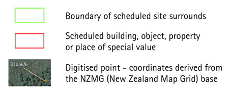
Disclaimer for all diagrams in appendix 1b
The diagrams show a red polygon (or several polygons)
around the scheduled item. These polygons are indicative and shown for
information purposes only.
The diagrams show a green polygon at the extent of the
protected surrounds of the scheduled item. Where this polygon is defined
by latitude and longitude coordinates, these coordinates form the definitive
extent of the item's protected surrounds, with all other identifying
information (as described in the surrounds definition text) being supplementary.
Where this polygon is not defined by coordinates, the
identifying information as described in the surrounds definition text
forms the definitive extent of the item's protected surrounds, with
the green polygon being indicative only.
Some diagrams may include parts of an item extending
below mean high water springs (MHWS). Areas below MHWS fall within the
jurisdiction of the Auckland Regional Council, and are therefore outside
the jurisdiction of this Plan. Any areas below MHWS are indicative and
shown for information purposes only.
4.0 Diagrams of
scheduled buildings, objects, properties or places of special
value
Diagrams legend