District Plan Hauraki Gulf Islands Section - Proposed 2006
(Notified version 2006)
Street index |
Planning maps |
Text |
Appendices |
Annexures |
Section 32 material |
Plan modifications |
Help |
Notified - Home |
Decision - Home
Part Introduction
1.1 Introduction
1.2 Overview of Plan layout and contents
1.3 The development of the Plan
1.4 The structure of the Plan
1.5 Monitoring
1.6 Procedural information
1.1 Introduction
The district plan is a legal document prepared under
the Resource Management Act 1991 ('RMA'). It controls land use activities
and subdivision.
The Auckland City District Plan consists of three sections:
- the Hauraki Gulf Islands Section
- the Isthmus Section
- the Central Area Section.
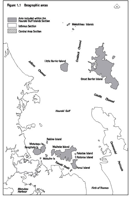
The geographic areas covered by each section are shown
on figure 1.1: Geographic areas. This document is the Hauraki Gulf Islands
Section of the District Plan ('the Plan').
The Hauraki Gulf islands ('the islands') includes more
than 65 islands with the largest being Waiheke and Great Barrier.
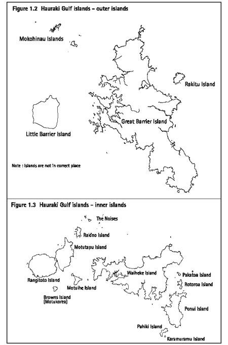
Inner and outer islands
For the purposes of the Plan, the islands are divided
into two groups as follows:
- The inner islands - includes Waiheke,
Pakatoa, Tarahiki, Rotoroa, Ponui, Pakihi, Rangitoto, Motutapu, Browns
(Motukorea), Motuihe, Rakino, The Noises, Karamuramu.
- The outer islands - includes Great
Barrier, Little Barrier, Mokohinau, Rakitu, Kaikoura.
These islands are shown on figure 1.2: Hauraki Gulf
islands - outer islands and figure 1.3: Hauraki Gulf islands - inner
islands
1.2 Overview of
Plan layout and contents
The Plan is prepared as a single document which addresses
the resource management issues affecting this part of the city. The
document should be read as a whole so that the common themes and the
relationships between the various provisions can be understood.
The Plan consists of the following:
- the text - one volume
- the appendices and annexures - two volumes
- the maps - two volumes (one for inner
islands, and one for outer islands).
1.2.1 The Plan text and appendices
The text and appendices of the Plan are organised as follows:
Part no
|
Title
|
Description
of contents
|
1
|
Introduction
|
Provides an outline of the Plan
structure and general introductory material.
|
2
|
Resource management overview
|
Identifies issues at a strategic
level for the islands.
|
3
|
Strategic management areas
|
Identifies issues and sets a strategic
direction by means of strategic management areas for Great Barrier,
Waiheke and the other islands.
|
4
|
General rules
|
Contains some general rules which
apply throughout the islands. It includes rules relating to temporary
activities, construction noise, signs and lighting.
|
5
|
Network utility services
|
Contains objectives, policies
and rules relating to network utility services such as roading, electricity
and telecommunications.
|
6
|
Financial contributions
|
Contains objectives, policies
and rules relating to financial contributions which may be taken by
the council in conjunction with subdivision and development.
|
7
|
Heritage
|
Contains objectives and policies
relating to heritage. Contains rules applying to scheduled heritage
items which are identified on the planning maps and further detailed
in appendices 1-3.
|
8
|
Natural hazards
|
Contains objectives, policies
and rules relating to natural hazards. Some natural hazards are identified
on the planning maps.
|
9
|
Hazardous facilities
and contaminated land
|
Contains objectives,
policies and rules relating to:
facilities involving hazardous substances
land which has been or may have been contaminated
by past activities involving hazardous substances.
|
10a
|
Land units: objectives, policies
and activity tables
|
Contains objectives, policies,
activity tables and some specific rules applying to land which has been
identified on the planning maps as being within a land unit.
|
10b
|
Settlement areas: objectives,
policies and activity tables
|
Contains objectives, policies,
activity tables and some specific rules applying to land on Great Barrier
which has been identified on the planning maps as being within a settlement
area.
|
10c
|
Development controls for land
units and settlement areas
|
Contains rules controlling development
within land units and settlement areas.
|
11
|
Assessment matters
|
Identifies matters of discretion
and assessment criteria applying to activities listed as discretionary
or restricted discretionary activities in the activity tables for land
units and settlement areas.
|
12
|
Subdivision
|
Contains objectives, policies
and rules applying to subdivision throughout the islands.
|
13
|
Connectivity and linkages
|
Contains objectives, policies
and rules applying to transport throughout the islands. It includes
requirements relating to vehicle access, parking and manoeuvring.
|
14
|
Definitions
|
Contains the meanings of terms
used in the Plan.
|
|
|
Appendices
|
Appendices 1-6 are the heritage
appendices and contain detailed information about scheduled items shown
on the planning maps. Also contains other supporting information for
part 7 - Heritage.
Appendices 7-13 contain information to be used
in conjunction with other parts of the Plan and the planning maps. Includes
guidance material.
|
|
|
Annexures
|
Non-statutory annexures containing
extra background information related to the Plan.
|
1.2.2 The planning maps
The planning maps display spatial information including:
- land units and settlement areas
- designations
- items which are scheduled for their heritage values
- natural hazards
- roading information
- other additional limitations.
Some items such as designations and heritage items are
identified on the planning maps by a map reference as well as a distinctive
notation. Those map references link to additional information contained
in the appendices to the Plan. An index of map references, which also
identifies the particular appendix that applies, is contained after
the planning maps.
Planning maps 1 to 33 cover the inner islands. Planning
maps 34 to 63 cover the outer islands.
1.3 The development of the Plan
1.3.1 Background
This Plan is the first review of the Hauraki Gulf Islands
Section of the District Plan which became operative in 1996. That Plan
was the first district plan produced by the council for the islands
following local government amalgamation in 1989 and the enactment of
the RMA in 1991.
1.3.2 Resource Management Act context
The purpose of the preparation, implementation and administration
of the Plan is to assist the council to carry out its functions in order
to achieve the purpose of the RMA. The statutory context set by the
RMA is further described in part 2 - Resource management overview.
1.3.3 Relationship with the council's strategic and annual plans
The council's strategic planning is done via the long-term
council community plan which is prepared under the Local Government
Act 2002. That document sets out the council's plans, policies and aims
for the next 10 years. The current document is called Focus on the Future
2004-2014.
The council is also required to prepare an annual plan
for each financial year setting out what it wants to achieve during
that period. Both the long-term council community plan and the annual
plan are prepared using a consultative process under the Local Government
Act 2002.
The district plan is most effective when it works together
with the long-term community plan, the annual plan, and other council
initiatives to promote good resource management outcomes.
1.3.4 Other agencies
The Plan is influenced by the planning documents of
other agencies. Those documents include national policy statements,
regional policy statements and plans, as well as management plans and
strategies prepared under other legislation.
1.3.5 Tangata whenua
In accordance with the RMA, the council must consider
the impacts of proposed activities and development on the relationship
between Maori and their ancestral lands, water, sites, waahi tapu and
other taonga.
Particular recognition is provided for iwi who have
traditional and unbroken occupation of an area. The council recognises
and develops formal relationships with iwi groups that have retained
their ahi kaa status.
Consultation with iwi is an important element to ensure
the fulfilment of the obligations towards Maori and the Treaty of Waitangi
required by the RMA.
1.3.5.1 Ngati Rehua
The council acknowledges Ngati Rehua as maintaining
their ahi kaa status of the islands and in particular Aotea (Great Barrier).
Ngati Rehua te moutere rongonui
|
Aotea is the renowned island
|
Ko Hirakimata te Maunga tapu
|
Hirakimata is the sacred mountain
|
Ko Te Moananui o Toi te huatahi te Moana
|
The great sea of Toi is the sea
|
Ko Rehua raua ko Te Rangiuangahuru
|
Rehua and Te Rangituangahuru
|
Nga tupuna
|
are the ancestors
|
Ko Ngati Rehua te Iwi
|
Ngati Rehua are the people
|
Ko Te Tuatara, Te Mauri me Tukaiaia
|
The Tuatara,Te Mauri and Tukaiaia
|
Nga Kaitiaki
|
are the guardians
|
Descendents of Ngati Rehua still live on Aotea today
and are able to trace their association back over many centuries. Ngati
Rehua history and traditional use of islands is evident in archaeological
sites, waahi tapu, and various sites of significance identified throughout
the islands. Many of these sites are situated around the coastal areas.
They include pa (earthwork fortifications) with extensive defensive
and habitation features; agricultural and settlement sites identifiable
by their still visible terracing, storage pit depressions and deposits
of food waste ('midden'); and stone-working sites. Some of the midden
have been dated to the earliest period of occupation, and provide information
on the past environment and food sources.
1.3.5.2 Ngati Paoa
The history of Maori settlement on Waiheke is one of
waves of settlement by different iwi (tribes). The island was coveted
for many reasons. Its natural environment was ideally suited for permanent
settlement; rich fishing grounds, freshwater streams and forests provided
ample food, water and building materials while the island's hilly landscape
and sheltered bays provided ideal locations for settlements. Waiheke
was also strategically located in an important waterway (the Hauraki
Gulf) and was at a crossroads for Maori seafarers journeying from the
north, east and west.
The council acknowledges that Waiheke is the ancestral
home of Ngati Paoa. It is recorded that Ngati Paoa occupied Waiheke
from as early as the 18th century and continue to do so and therefore
are recognized as ahi kaa of the islands and in particular, Waiheke.
It is important that proposed developments on Waiheke
have regard to waahi tapu, wai tapu and culturally significant sites.
These include pa (earthwork fortifications) with extensive defensive
and habitation features; agricultural and settlement sites, terracing,
storage pit depressions and deposits of food waste ('midden'); and stone-working
sites.
1.3.6 The Hauraki Gulf Marine Park Act 2000
The Plan covers considerable areas which are subject
to the provisions of the Hauraki Gulf Marine Park Act 2000 (the 'HGMPA').
The role of the HGMPA is further described in part 2 - Resource management overview.
1.3.7 Consultation during the preparation of the Plan
The council undertook consultation in 2005 in preparation for drafting the proposed Plan.
Initial consultation
The main consultation period was from April to July
2005. Consultation during that period consisted of:
- Public meetings, workshops, nga hui, and one on one meetings.
- A photographic exercise on Waiheke.
- Inviting written feedback on a consultation
document which contained issues and options papers on a wide range of
topics.
Focus groups
At the close of consultation, the council analysed the
feedback forms received. From these, key issues were identified that
subsequently became topics for focus groups on Waiheke. The four topics
for the focus groups were:
- landscape
- transport
- sustainability
- future planning (including subdivision, growth, and providing for business activity).
An additional workshop was also held on Great Barrier
to give a further opportunity to discuss issues raised through the feedback
forms.
Telephone survey
The council commissioned an independent research company
to undertake a phone survey in late 2005. The survey was of a randomly
selected sample of 1002 on-island residents and off-island ratepayers
of Waiheke, Great Barrier and Rakino. The questionnaire used for the
survey was designed to get responses on the key issues that had emerged
from the consultation process and stakeholder feedback.
The survey provided a means of canvassing the views
of a wide range of people who may not have been previously involved
in the consultation process.
Consultation with other stakeholders
During the preparation of the Plan, the council has
also consulted with the following parties:
- the Auckland Regional Council ('ARC')
- the Department of Conservation ('DOC')
- the Ministry for the Environment (‘MFE’)
- tangata whenua
- network utility authorities.
Public notification
All the consultation identified above has been taken
into account in developing the Plan. Notification of the Plan provided
an opportunity for further public participation through the formal submission
and appeal process.
1.4 The structure of the Plan
1.4.1 Introduction
The Plan uses three techniques to group land into areas which need a specific planning approach. Those areas are:
- strategic management areas
- land units
- settlement areas.
These techniques are more particularly described in
part 3 - Strategic management areas and
parts 10a to 10c which deal
with land units and settlement areas. Part 3 sets out the issues, objectives
and strategy for each of the three strategic management areas. Parts
10a to 10c sets out the issues, objectives, policies and rules for the
land units and settlement areas.
1.4.1.1 Strategic management areas
The islands have been divided into three separate strategic management areas. The three areas are:
- Great Barrier
- Waiheke
- other islands.
An objective, policies and a strategy have been developed at a broad level for each strategic management area.
1.4.1.2 Land units
All land, other than formed roads, is allocated to either
a land unit classification or a settlement area.
The division into land units has been done by grouping
land according to common physical, locational, and development characteristics.
Each land unit classification carries with it a set
of issues, objectives, policies and rules.
The land units have been grouped as follows:
- landform 1-7
- island residential 1-2
- commercial 1-7
- Matiatia
- recreation 1-3
- rural 1-3
- conservation
- other islands - Rotoroa, Pakatoa.
1.4.1.3 Settlement
areas
Some specific locations on Great Barrier, which require
a more integrated management approach, are allocated to settlement areas
rather than land units. Each settlement area carries with it a set of
issues, objective, policies and rules. There are nine settlement areas
as follows:
- Tryphena
- Medlands
- Claris
- Okupu
- Whangaparapara
- Awana
- Okiwi
- Port Fitzroy
- Aotea (encompassing Motairehe and Kaoa).
1.4.2 Issues, objectives, policies and rules
The Plan states the following:
- the significant resource management issues for the islands
- the objectives for the islands
- the policies to implement the objectives
- the rules (if any) to implement the policies.
1.4.2.1 Issues
The issues are statements about existing or potential
problems in the islands that must be resolved to achieve sustainable
management. The issues statements in the Plan apply the RMA to the specific
circumstances of the islands.
1.4.2.2 Objectives
The objectives state the environmental outcome that
the council wants to see from resolution of the issue. Objectives identify
what the council wants to achieve in the environment by resolving the
problem.
Objectives may state an environmental outcome for a
strategic management area, land unit or settlement area. Alternatively
they may relate to issues which are not particular to one of these groupings.
Those issues include:
- network utility services
- heritage matters
- natural hazards
- hazardous facilities and contaminated sites.
1.4.2.3 Policies
Policies relate directly to objectives. They are broad
action steps that address aspects of an objective. Policies state what
the council is going to achieve, or what position it takes on the objective.
1.4.2.4 Rules
The Plan includes rules for the purpose of carrying
out the council's functions under the RMA and achieving the objectives
and policies of the Plan. The rules derive from the objectives and policies
and link directly to them.
The type, form and scale of different activities are
controlled by rules. All rules in the Plan have the force of statutory
regulation.
1.4.3 Other methods
1.4.3.1 Regulatory
As well as the rules contained in this Plan, the council
will use other regulatory methods such as bylaws, the Building Act 2004
and engineering standards to achieve the objectives and policies. In
some instances these other regulatory mechanisms will adequately control
the effects of some activities which might otherwise be addressed through
the Plan. The council will also consider using development contributions
under the Local Government Act 2002.
1.4.3.2 Non-regulatory
Where appropriate, the council will also use non-regulatory
methods such as:
- education and training
- research and investigation
- monitoring
- providing council works and services - capital works, advocacy, and co-ordination
- reaching private agreements
- conservation covenants
- economic instruments - incentives, bonds, and charges for the use of services and resources
- land purchase.
1.5 Monitoring
The council is required to gather such information and
undertake or commission such research as is necessary to carry out effectively
its functions under the RMA. This includes monitoring the efficiency
and effectiveness of policies, rules, or other methods in the Plan.
The following types of monitoring will be undertaken
by the council:
- Collecting and analysing information about
resource consents.
- Monitoring complaints and enforcement
actions.
- Undertaking surveys, eg user satisfaction
surveys, land use surveys, ecological surveys.
- Monitoring trends through analysing statistics
eg census, accident statistics, building consents, traffic data.
- Scientific measurement, eg of land or
water quality.
- Maintaining records of natural hazards.
1.6 Procedural
information
1.6.1 General duty to comply
Compliance with the Plan and the RMA does not remove
the need to comply with all other applicable acts, regulations, bylaws
and rules of law.
Activities which do not require a building consent under
the Building Act 2004 may still require a resource consent under this
Plan.
1.6.2 Types of activities
The RMA classifies activities into the following types:
- permitted activities
- controlled activities
- discretionary activities
- restricted discretionary activities
- non-complying activities
- prohibited activities.
The Plan includes all of these activity types, except
for controlled activities. The activity types used in the Plan are described
further below.
1.6.2.1 Permitted
activities
A permitted activity does not require a resource consent
if it complies with all the relevant rules in the Plan. This includes
compliance with the development controls referred to in clause 1.6.2.2
below. The Plan uses this approach to provide for activities which can
be accommodated without adverse effects provided certain pre-set standards
are met.
1.6.2.2 Discretionary
activities
A resource consent is required for a discretionary activity.
The council may grant or refuse the application and can impose a wide
range of conditions.
The Plan provides for two types of discretionary activities:
- listed discretionary activities
- development control modifications.
- Listed discretionary activities
Some activities, because of their scale, location,
intensity or method of operation need to be individually assessed to
determine whether they are suitable on a particular site. It may also
be necessary to tailor conditions to the particular circumstances of
the site or activity. The Plan lists such activities as discretionary.
- Development control modifications
The Plan sets development controls to control
the effects of activities on the environment. Development controls are
a type of rule and set standards for such matters as:
- the bulk and location of buildings (including
height, distance from the boundary, building coverage)
- conservation and amenity matters such
as noise, earthworks, vegetation clearance and setbacks from the coast,
wetlands or water bodies.
The controls are generally appropriate for most
developments. However not every development control will be appropriate
for every site and every proposal. In some circumstances the characteristics
of a site may make strict compliance with the development controls inappropriate
or unnecessary. Also, a degree of non-compliance may be able to be mitigated.
The Plan therefore provides for modifications
to the development controls to be considered as a discretionary or,
in some instances, a restricted discretionary application. This approach
means that the particular circumstances of the site and the proposal
can be assessed on its merits.
1.6.2.3 Restricted
discretionary activities
A resource consent is required for a restricted discretionary
activity. The Plan must specify the matters over which the council has
restricted its discretion. The council's ability to refuse the application
and impose conditions is restricted to these matters.
A restricted discretionary activity is a more limited
type of discretionary activity. The Plan uses this approach in circumstances
where it is possible to identify a limited range of effects which need
to be assessed.
In some circumstances the Plan specifically provides
that restricted discretionary activities do not require public notification
or service of notice.
1.6.2.4 Non-complying
activities
A resource consent is required for a non-complying activity.
The council may grant or refuse the application and can impose a wide
range of conditions. There are extra tests under the RMA which the council
must consider when assessing a non-complying activity.
There are two types of non-complying activities in the
Plan:
- Listed activities which are specifically
identified as non-complying.
- Activities which default to a non-complying
status because they are not specifically provided for as permitted,
discretionary or restricted discretionary.
1.6.2.5 Prohibited
activities
No application can be made for a prohibited activity.
Neither can the council grant resource consent for such an activity.
It can only be provided for in the Plan by means of a plan change.
1.6.3 Resource consents
1.6.3.1 Types of
resource consent
The council can grant two types of resource consent:
- land use consent
- subdivision consent.
Other resource consents such as water permits, discharge
permits, or coastal permits are issued by the Auckland Regional Council
('ARC').
1.6.3.2 Requirement
for a resource consent
A resource consent is required for any use of land which
contravenes a rule in the Plan unless:
- A resource consent has already been granted.
- The use has existing use rights
under section 10 of the RMA.
- The use is provided for by section
4(3) of the RMA. This subsection applies to the work and activity of
the crown within areas of land held or managed under the Conservation
Act.
- The use is a public work or project
or work undertaken by a requiring authority under a designation.
Part 12 - Subdivision sets out the rules applying to
the subdivision of land. Except as provided for in section 11 of the RMA, subdivision requires a resource consent.
1.6.3.3 Resource
consent processes
Additional information can be obtained from the council
about resource consent processes. This includes information about:
- applying for a consent (including information requirements and council fees)
- notification procedures
- lodging submissions
- hearing and decision processes
- conditions of consent
- appeal rights
- changing or cancelling conditions.
1.6.4 Changes to the Plan
1.6.4.1 Public plan changes and variations
The RMA sets out a formal process whereby the council
can propose changes or variations to the Plan. Plan changes apply to
an operative plan. Variations apply to a proposed plan or plan change.
Any plan changes or variations will need to be publicly notified and
there are submission, hearing and appeal rights.
The council has a responsibility to maintain a district
plan which is current and relevant and which addresses contemporary
issues in the environment. The provisions of the Plan may therefore
be changed or varied as necessary.
1.6.4.2 Private
plan changes
The RMA sets out a formal process whereby any person
can lodge a request with the council seeking a change to the Plan. Further
information about this process, including the information requirements,
and likely costs, can be obtained from the council.
1.6.5 Designations and notices of requirement
A designation is a form of land use authorisation which
is available to a requiring authority. Requiring authorities include
ministers of the crown, local authorities (such as the council), or
network utility operators. A designation is for a public work such as
a school, police station, road, motorway, park, drainage or infrastructure
systems.
Sites which are subject to a designation are identified
on the planning maps by means of a distinctive notation and a map reference
number. The reference number links to further information in
appendix
7 - List of designations, which describes the designation and any associated
conditions.
The effect of a designation is to override the general
provisions of the Plan and any resource consent, for activities that
are consistent with the designated purpose. Once a designation is included
in the Plan, no one may without the prior written consent of the requiring
authority do anything to the affected land that would prevent or hinder
it being used for its designated purpose.
Designated land is also classified into a land unit
or settlement area to indicate the purposes for which the land could
be used if it was not designated. The provisions of the Plan apply to
the designated land only to the extent that the land is used for a purpose
other than its designated purpose.
New designations
From time to time during the life of the Plan, the council
may receive notices of requirement from requiring authorities seeking
to designate land. The RMA sets out a formal process applying to notices
of requirement. That process involves public notification and includes
submission, hearing and appeal rights.
Once the requiring authority has given the notice of
requirement to the council, no one may, without the prior written consent
of the authority, do anything that would prevent or hinder the public
work or project or work.
1.6.6 Heritage orders
A heritage protection authority may issue a heritage
protection order to protect places of special interest, character, intrinsic
or amenity value or visual appeal or of special significance to tangata
whenua. The RMA sets out a formal process applying to heritage protection
orders. That process involves public notification and includes submission,
hearing and appeal rights. Once a heritage order has been issued no
one may do anything which would nullify its effect.
1.6.7 Unreasonable noise and adverse effects
The RMA requires every occupier of land (including premises)
to adopt the best practicable option to ensure that the emission of
noise from that land does not exceed a reasonable level. This obligation
applies whether or not the noise is otherwise authorised under the RMA
by, for example, a rule in the Plan or a resource consent.
As set out in the RMA, every person has a duty to avoid,
remedy or mitigate any adverse effect on the environment arising from
an activity carried on by or on behalf of that person, whether or not
the activity is in accordance with a rule in the Plan, a resource consent
or a lawful existing use.